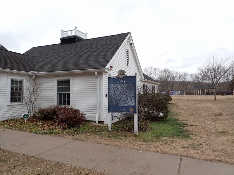
On Hamburg Road (Connecticut Route 156) north of Beaver Brook Road, on the right when traveling south.
These lands were first settled in 1664 after
the Connecticut General Assembly had approved
establishment of a plantation on the east
side of the Connecticut River in 1663. The
"Loving Parting" between Saybrook and East
Saybrook was signed on . . . — — Map (db m281302) HM
On Hamburg Road (Connecticut Route 156) at Sterling City Road, on the right when traveling north on Hamburg Road.
Baborsky, William •
Beebe, M. Arthur •
Blackwell, Elmer H. •
Butler, William •
Clark, Ansel Carl •
Clark, Harold F. M. •
Cone, Leslie B. •
Cunningham, Niles F. •
Czikowsky, William •
Damen, Peter •
Ely, Ernest S. •
Ely, Julian . . . — — Map (db m280815) WM
On Hamburg Road (Connecticut Route 156) north of Beaver Brook Road, on the right when traveling south.
Commemorating the
Tercentenary Celebration
August 5-7, 1965
of the
ancient town of Lyme,
now the towns of Old Lyme, Lyme,
parts of East Lyme and Salem.
Originally a part of Saybrook, Lyme
became a new town by the articles
of agreement . . . — — Map (db m281309) HM
On Hamburg Road (Connecticut Route 156) north of Beaver Brook Road, on the right when traveling north.
In honor of the men & women of Lyme who served their country in the armed forces in
World War II & Korea and in memory of those who gave their lives — — Map (db m281434) WM
On River Road (Connecticut Route 431) 0.1 miles west of Ferry Road ( Route 148), on the right when traveling west.
State Historic Landmark
For over two hundred years the Chester-Hadlyme Ferry has provided public transportation at this site. The first crossing was initiated by Johnathan Warner of Chester in 1769. Known as Warner's Ferry, it was privately . . . — — Map (db m83888) HM
On River Road (Connecticut Route 431) 0.1 miles west of Ferry Road ( Route 148), on the right when traveling west.
This Viewpoint extends the museum sites of the Connecticut Impressionist Art Trail – Connecticut’s Millennium Legacy Trail – to the outdoor settings that artists portrayed at the turn of the 20th century in a manner that came to be . . . — — Map (db m83999) HM
Near Ferry Road (Connecticut Route 148) west of Geer Hill Road ( Route 431), on the right when traveling west.
William Gillette's Secretary and Confidante
A Japanese expatriate who exemplified the Connecticut state motto, "He who transplants sustains," Yukitaka Osaki came to the United States with his elder brother, Yukio, in 1888. The Ozaki family . . . — — Map (db m266480) HM
Near Ferry Road south of Sandpiper Point Road when traveling south.
Anadromous fish live most of their adult lives in marine
waters and return to their freshwater streams to spawn.
Juvenile fish hatched on the spawning grounds remain
in these protected nursery areas. At a certain age these
fish begin migrating . . . — — Map (db m268188) HM
On Lyme Street, on the right when traveling north.
Boxwood
Built 1842
This property has been
placed on the
National Register
of Historic Places
by the United States
Department of the Interior — — Map (db m268060) HM
Near Ferry Road east of Shore Road ( Route 156), on the right when traveling south.
The British Raid on Essex
On April 7-8, 1814, a British raiding force of 136 sailors and marines rowed six miles up the Connecticut River from warships anchored in Long Island Sound to attack American shipping in Essex, then known as . . . — — Map (db m272239) HM
You are standing about three miles from the mouth of the Connecticut River, the longest river in New England. It measures over 400 miles from its source -- a series of linked, small lakes in northern New Hampshire, almost on the Canadian Border -- . . . — — Map (db m268368) HM
Near Ferry Road south of Sandpiper Point Road when traveling south.
Dr. Roger Tory Peterson - A True Conservationist
8/28/08 - 7/28/96
This Wildlife Area at Great Island has been dedicated to the memory of Dr. Roger Tory Peterson, an Old Lyme resident and renowned naturalist, educator, author and artist. . . . — — Map (db m268283) HM
On Lyme Street at Wyckford Lane, on the right when traveling south on Lyme Street.
Florence Griswold House
has been designated a
National Historic Landmark
This property possesses national significance
in commemorating the history of the
United States of America
1993
National Park Service
United . . . — — Map (db m308865) HM
On McCurdy Road, on the right when traveling south.
On August 22, 1824, General Lafayette had breakfast across the road at Richard McCurdy's home on his way from New York to Boston. — — Map (db m266054) HM
On Sill Lane at Boston Post Road (U.S. 1), on the right when traveling south on Sill Lane.
Sawmill worker
Enslaved nearby
by Edward Dewolf
Petition attested to his
good character 1704
"Industrious in his
master's business" — — Map (db m268107) HM
On Lyme Street at High School Road, on the left when traveling north on Lyme Street.
As early as the 1640’s settlers from Saybrook cleared and planted land on the east side of the Connecticut River in what is now Old Lyme. The first recorded grant of land, in 1649, was to Matthew Griswold in the Black Hall quarter. By 1665 the . . . — — Map (db m302005) HM
Near Ferry Road south of Sandpiper Point Road when traveling south.
The osprey is one of Connecticut's wildlife success stories.
The overuse of pesticides, primarily DDT, caused a
dramatic decline in osprey numbers and, by 1974, there
were only 9 active nests in Connecticut. The use of DDT
has been banned in . . . — — Map (db m268281) HM
On Old Shore Road at Buttonball Road, on the right when traveling west on Old Shore Road.
Soldier, mariner, fiddler
Enslaved
by Gov. Matthew Griswold
Baptized 1755, sold 1775
Served in
Revolutionary War
to gain his freedom — — Map (db m280542) HM
On Lyme Street at Academy Lane, on the left when traveling north on Lyme Street.
Born a short distance from this place, he later practiced law here
Responded to the Lexington Alarm as a colonel in April, 1775. Retired as a major general in July, 1782. Charter member, American Union Lodge, and master thereof, 1779. Elected . . . — — Map (db m268089) HM WM
On Lyme Street (U.S. 1) north of Interstate 95, on the right when traveling south.
Also called Tempy
Daughter of Jenny
Born here enslaved
by William Noyes
Passed to Rev. Matthew Noyes
Gravestone Old Durham Cemetery — — Map (db m280810) HM
On Lyme Street (Interstate 1) north of Interstate 95, on the right when traveling south.
As a buffer between the Griswold family's farm
fields and Lyme Street, this area of the property was
historically somewhat overgrown. Photos from the
Museum's archives show that artists set their easels
up in the woodland for a good view of . . . — — Map (db m280814) HM
On Lyme Street at McCurdy Road, on the right when traveling south on Lyme Street.
Home of suffrage leader Katharine Ludington, 1869-1953. President of Connecticut Woman Suffrage Assn. & leader of Natl. League of Women Voters. — — Map (db m266058) HM
On Lyme Street (U.S. 1), on the right when traveling south.
Across Lyme Street
Enslaved
by Dr. John Noyes
Willed 1733
to Mary Hudson Noyes
Freed by Mary Noyes Ely 1743
"to be his own man" — — Map (db m268184) HM
On Lyme Street at Library Lane, on the right when traveling north on Lyme Street.
Between 1670 and 1820 more than 200 enslaved African Americans and Native Americans labored
in the historic town of Lyme. Today, small bronze plaques mark sites of enslavement on Lyme Street
and serve as memorials to those once held here in . . . — — Map (db m280568) HM
On Headquarters Road at Trail 1 Road, on the left when traveling north on Headquarters Road.
This statue honors the young men of the Civilian Conservation Corps who from 1933 to 1942, through the construction of trails, roads, bridges and buildings helped create access to our state parks and forests. The legacy of their natural resource . . . — — Map (db m265487) HM
On Headquarters Road at Trail 1 Road, on the left when traveling north on Headquarters Road.
To Honor The Men Of
Camp Lonergan
Company 179
Established 1933
Civilian Conservation Corps
1933-1942
Created By
President Franklin D. Roosevelt
Renewing The Country's Natural Resources
And Challenging The Human Spirit
Of A Nation . . . — — Map (db m265482) HM
On Main Street (Connecticut Route 138) at Shetucket Turnpike ( Route 165), on the right when traveling east on Main Street.
Upon these lands settled volunteers who had fought in the Narragansett Indian Warre 1675-76. In October, 1696 Lieutenant Thomas Leffingwell of Norwich and Sergeant John Frink of Stonington petitioned the General Court "that they with the rest of . . . — — Map (db m140774) HM
On Fitchville Road (Connecticut Route 608) at River Road, on the right when traveling east on Fitchville Road.
Bozrah
This area was originally a part of the Town of Norwich "nine miles square” acquired from the sachems of the Mohegan Indians in June 1659, a portion of which later was known as the New Concord Society. In the early 1700’s this land, . . . — — Map (db m101711) HM
On Fitchville Road (Route 608) at River Road, on the right when traveling east on Fitchville Road.
This memorial will forever honor the men and women who bravely
served during the Civil War era
The actions of those who answered the call to duty will be remembered for their
sacrifice in defense of freedom and liberty
Jared A. Abell · . . . — — Map (db m101737) WM
On Fitchville Road (Route 608) at River Road, on the right when traveling east on Fitchville Road.
This memorial will forever honor the men and women who
bravely served during the Gulf War and War on Terror eras
The actions of those who answered the call to duty will be remembered for their
sacrifice in defense of freedom and liberty
Amy . . . — — Map (db m101742) WM
On Fitchville Road (Connecticut Route 608) at River Road, on the right when traveling east on Fitchville Road.
This memorial will forever honor the men and women who
bravely served during the Korean War era
The actions of those who answered the call to duty will be remembered for their
sacrifice in defense of freedom and liberty
Ralph E. Banning · . . . — — Map (db m101740) WM
On Fitchville Road (Connecticut Route 608) at River Road, on the right when traveling east on Fitchville Road.
This memorial will forever honor the men and women who
bravely served during the Revolutionary War and War of 1812 era
The actions of those who answered the call to duty will be remembered for their
sacrifice in defense of freedom and liberty . . . — — Map (db m101736) WM
On Fitchville Road (Route 608) at River Road, on the right when traveling east on Fitchville Road.
This memorial will forever honor the men and women who
bravely served and are still serving our great Nation
“Greater love hath no man than this that a man lay down his life for his friends.”
Thank you for your service
From . . . — — Map (db m101743) WM
On Fitchville Road (Route 608) at River Road, on the right when traveling east on Fitchville Road.
This memorial will forever honor the men and women who
bravely served during the Vietnam era
The actions of those who answered the call to duty will be remembered for their
sacrifice in defense of freedom and liberty
Andre J. Arpin, Jr. · . . . — — Map (db m101741) WM
On Norwich-Colchester Turnpike (Route 608) at Bozrah Street Ext, on the left when traveling west on Norwich-Colchester Turnpike.
In Honor of The Men of Bozrah Who
Responded To Their Country’s Call
In The Great World War 1917 — 1919
★Ambrose J. Rivers
Isadore Aronofsky · Charles N. Bentley · Harold W. Bentley · John T. Beswick · Charles N. Congdon · George . . . — — Map (db m101744) WM
On Fitchville Road (Connecticut Route 608) at River Road, on the right when traveling east on Fitchville Road.
This memorial will forever honor the men and women who
bravely served during the World War I era
The actions of those who answered the call to duty will be remembered for their
sacrifice in defense of freedom and liberty
Isadore Aronofsky · . . . — — Map (db m101738) WM
On Fitchville Road (Connecticut Route 608) at River Road, on the right when traveling east on Fitchville Road.
In Grateful Memory Of
Those Men And Women Of Bozrah Who Gave
Themselves Unreservedly In The Hour Of
Their Country’s Need In World War II
★Peter Janowicz · Lloyd T. Abel, Jr. · Fiore Antonaccio · Barbara K. Bathgate · Donald Beckwith · . . . — — Map (db m101709) WM
On Fitchville Road (Connecticut Route 608) at River Road, on the right when traveling east on Fitchville Road.
This memorial will forever honor the men and women who
bravely served during the World War II era
The actions of those who answered the call to duty will be remembered for their
sacrifice in defense of freedom and liberty
Lloyd T. Abel, Jr. . . . — — Map (db m101739) WM
On Main Street at Norwich Avenue, on the right when traveling north on Main Street.
Colchester
The eighth town in the Colony incorporated before 17OO, Colchester received its charter in 1698. Among the early settlers from Wethersfield was Nathaniel Foote, whose ancestors came from Colchester, England. He obtained a deed for the . . . — — Map (db m98960) HM
On Main Street near Norwich Avenue, on the right when traveling north.
Colchester
Honors Its Dead
Who Fell
In The War
For The Union
1861-5.
(north side )
Erected
Sept. 17.
1875.
( west side )
Roll of Honor
Capt. C.W. Cook · Lt. M.A. Taintor · A.M. Fox · John Morgan · Ja’s Elderman · . . . — — Map (db m98958) HM
On Broadway Street at Main Street, on the left when traveling south on Broadway Street.
Colchester Remembers
1917 World War 1918
Acranovitch, Saul · Backus, John E. · Bailey, Charles M. · Beebe, Leslie P. · Bicelow, Cecil T. · Bigelow, Dennis W. · ★Bigelow, Donald A · Bigelow, Henry F. · Blacker, James J. · Blatt, Isidor · . . . — — Map (db m98967) WM
On Broadway Street at Main Street, on the left when traveling north on Broadway Street.
This memorial was erected
in honor of those men and
women from Colchester who
served their country in
time of need.
They sought not personal
glory but the preservation
of liberty and freedom.
They fought against
aggression . . . — — Map (db m98968) WM
On Boardwalk 0.3 miles east of Baptist Lane, on the left when traveling east.
East Lyme was settled in the 1650s and became incorporated as a town in 1839. Records from 1840 indicated that 1,412 people lived in this 34.8 square mile town. An important settlement in the area was the Thomas Lee house that was built in 1660. . . . — — Map (db m227268) HM
On Boardwalk 0.2 miles east of Baptist Lane, on the right when traveling east.
The Niantic Bay and River contribute to the area's rich history of leisure and sport. At a time when there was greater distinction between city and country life, any city dwellers traveled to Niantic on the train to enjoy the beaches and seaside . . . — — Map (db m227266) HM
On West Main Street (Connecticut Route 156) at Liberty Way, on the right when traveling west on West Main Street.
"It fell out the first winter of our settling there that Jonathan Rudd being to be maried at Saybrooke there falling out at yt tyme a great snow the magistrate intended to goe downe thither was hindered by the depth of yt snow where upon . . . — — Map (db m225334) HM
On Pennsylvania Avenue (Connecticut Route 161) at Smith Street, on the left when traveling north on Pennsylvania Avenue.
Settled in the 1640's in part of Lyme and New London. East Lyme was made a separate town in 1839 by the Connecticut General Assembly. In what was originally a farming area along the Old Post Road, a cottage textile indistry developed similar to . . . — — Map (db m32330) HM
On Main Street (Connecticut Route 156) at Pennsylvania Avenue ( Route 161), on the left when traveling east on Main Street.
Honor RollAntoniac, Peter • Atkinson, Arthur W. • Bacon, Howard N. • Bacon, Jerry B. • Banta, Richard • Beck, Andrew • Beck, John A. • Beckwith, George A. • Beckwith, Oliver J. • Beebe, Benjamin M. • Beebe, Henry A. • Beebe, Lewis • Bond, Henry W. • . . . — — Map (db m32328) HM
On Main Street (Connecticut Route 156) at Pennsylvania Avenue ( Route 161), on the left when traveling east on Main Street.
[ left panel ]
East Lyme
Vietnam
God Bless These Men
Who Could Give No More
* John M. Bath
* Donald K. Walsh
May We Always Remember
- Never Forget –
These Courageous Men From
Our Town Who Fought For
Right When So Much . . . — — Map (db m32329) WM
On Boardwalk east of Baptist Lane, on the right when traveling east.
The McCooks of Hartford were a distinguished family. During the 1800s the men of the family were known as the "Fighting McCooks."
In 1869, the McCook family purchased 16 acres with 1750 feet of shoreline known as Champlin Point. On this land . . . — — Map (db m227265) HM
Near Boardwalk just east of Baptist Lane, on the left when traveling east.
The railroad between New Haven and New London was originally a single track. To allow for higher speed and more frequent trains the railroad was double-tracked and completed in 1894. At that time the "Hole in the Wall" was constructed. Underpasses . . . — — Map (db m227249) HM
On Boardwalk 0.3 miles east of Baptist Lane, on the left when traveling east.
Prior to the 1800s, travelers came to East Lyme by boat or horse and wagon. With the advent of the steam train, countless horses were replaced by the "Iron Horse." The railroad connected people and towns like never before.
Built between 1850 . . . — — Map (db m227267) HM
On Meeting House Hill Road at Bullard Road, on the right when traveling north on Meeting House Hill Road.
Franklin
In 1663 the uplands and meadows of this area, part of the Norwich “nine miles square" acquired from the Mohegan Indian chief Uncas and known as West Farms, were divided among certain occupants of the town plot of Norwich, and . . . — — Map (db m141214) HM
On Meeting House Hill Road at Pound Hill Road, on the right when traveling north on Meeting House Hill Road.
Honor Roll
Dedicated by the Citizens of
Franklin
To Those Who Served in
World War II
1941 - 1946
Richard E. Armstrong · Robert E. Armstrong · Walter V. Armstrong · John B. Ayer · Frank Babie · John Babie · Eugene J. Borque · Charles . . . — — Map (db m141212) WM
On Voluntown Road (Connecticut Route 138) at Bethel Road, on the right when traveling west on Voluntown Road.
Griswold
Settlers were attracted to this area, then part of Preston, by the rich land of the Pachaug River Valley. The first permanent settlement was founded near Pachaug about 1690 on land purchased from Owaneco, sorn of Uncas, the Mohegan . . . — — Map (db m140777) HM
On Voluntown Road (Route 138) at Old Bethel Road, on the right when traveling west on Voluntown Road.
To the Memory of
The Revolutionary Soldiers
Of Ancient Pachaug
Who Gave Their Lives to Establish a
Free and Independent Country
Dulce et decorum est pro patris mori
(It is sweet and fitting to die for your country)
Solomon Coit · . . . — — Map (db m221579) WM
On E Main Street (Connecticut Route 201) at N Main Street ( Route 12), on the left when traveling north on E Main Street.
Erected In Honor Of Those From
The Town Of Griswold Who
Served In The Korean Conflict
Richard A. Albro · Robert Allanach · Ernest L. Arremony · Edmund J. Arremony · John Arremony · Phillip F. Arremony · Lawrence J. Arthur · Chester J. . . . — — Map (db m140814) WM
534 entries matched your criteria. The first 100 are listed above. Next 100 ⊳