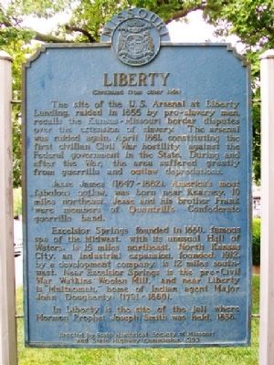
On Water Street north of Kansas Street, on the left when traveling north.
Early border town, prominent trading and outfitting center, and one of the farthest northwest of U. S. towns to be based on southern culture and economy. Settled about 1820, mainly by southern pioneers, the town became the seat of justice for . . . — — Map (db m81749) HM
Near West Shrader Street west of Gallatin Street, on the right when traveling east.
Private David Drake Blue
(1818-1896)
Born in Kentucky, David Drake (Blue) moved to Liberty in the 1850’s, along with Miles C. Drake’s other enslaved estate. He is recorded on census records through his live as “mulatto,” meaning he was . . . — — Map (db m274063) HM
On Kansas Street at Main Street, on the left when traveling east on Kansas Street.
This property built in 1935-36
has been placed on the
National Register
of Historic Places
by the United States
Department of Interior
1993 — — Map (db m68186) HM
On Water Street north of Mill Street, on the left when traveling north.
Originally John Owens' log tavern near Liberty Spring. Used for court sessions until 1831, when the permanent court house was built on the square.
Bicentennial 1976 — — Map (db m68310) HM
Col. John Thornton, Elisha Cameron and James Gilmore served as the county's first administrative judges. They met at Owen's Tavern until a brick courthouse was built and later burns. In 1869, a second courthouse was constructed. A wooden statue . . . — — Map (db m68275) HM
This farm established by Walthus L. Watkins, centered around his woolen factory built 1860-1861. It operated for 40 years with mass production machines. This farm (Bethany) also boasted a grist mill, flour mill and saw mill, church and octagonal . . . — — Map (db m46134) HM
On North Water Street 0.1 miles north of East Mississippi Street, on the right when traveling north.
Built in 1852 by Major Alvan Lightburne as his private residence. This 24 room Greek Revival plantation home is one of Northwest Missouri’s largest surviving antebellum mansions. Union soldiers camped on the grounds during the Civil War. Restored in . . . — — Map (db m46678) HM
On Crawford Lane at North Grover Street on Crawford Lane.
Believed built by Graham Hughes 1849. Brick kitchen added 1860, interior woodwork 1880. Owned by Wynoop Kiersted, Civil Engineer 1903-1934 and by descendants until 1959. Present owners are Mr. and Mrs. Howard Pavelchek. — — Map (db m46577) HM
On North Water Street 0.2 miles north of East/West Mississippi Street when traveling north.
Following statehood in 1821, the education of enslaved and free African Americans was discouraged in Missouri. Abolitionist literature and the fear of possible revolts by the enslaved led the Missouri General Assembly to pass a literacy law in . . . — — Map (db m252168) HM
On Campbell Drive south of South Liberty Parkway, on the right when traveling south.
The Testimony of Eight Witnesses
Be it known unto all nations, kindreds, tongues, and people, unto whom this work shall come that Joseph Smith Jun. the translator of this work has shown unto us the plates of which hath been spoken. Which have . . . — — Map (db m311688) HM
In 1803, President Thomas Jefferson buys the Louisiana Purchase from France for $15 million. It remains one of the greatest acquisitions in American history. In 1804, Jefferson sent Meriwether Lewis and William Clark to explore and map the . . . — — Map (db m68373) HM
Near Northeast Pleasant Valley Road east of Northeast Antioch Road, on the right when traveling east.
In 1824, William Allen, of Howard County, Missouri, applied for and received a land patent for the original 80 acres of land and later purchased additional land where the Atkins-Johnson Farm is today. Soon after, 130 acres of the land was sold to . . . — — Map (db m252138) HM
Near Old Missouri 210 0.5 miles east of Missouri Hiway 291.
The Liberty Landing, also known as Baxter’s Landing, located at the base of the bluffs one half mile west of Missouri 291 Highway, played a significant role in the history and development of Liberty, Missouri as well as Clay County. In use from 1829 . . . — — Map (db m46604) HM
On Grover Street south of Corbin Street, on the right when traveling south.
Samuel C. Houston, the first African American City Councilman in Liberty, Missouri organized a committee of community volunteers to host Juneteenth in Clay County on June 17, 1989 in Bennett Park. It was the first Juneteenth celebration held in a . . . — — Map (db m273128) HM
On NW River Park Drive (Missouri Route 9) 0.1 miles east of East Street, on the right when traveling east. Reported permanently removed.
Northwest Missouri Tinderbox
Conflict and uncertainty were widespread in northwest Missouri in the summer of 1864. Federal forces struggled in a heavy-handed manner to control areas much too large for their capabilities. Raiders from . . . — — Map (db m65997) HM
On West Shrader Street west of Gallatin Street, on the right when traveling east.
James A. Gay
(1882-1985)
Professor (Prof.) James A. Gay, centenarian and principal of Garrison School for 22 years, was born in Fayette, Georgia, the son of Felix and China Gay. His grandfather was the son of a white plantation owner who . . . — — Map (db m274675) HM
Near West Shrader Street west of Gallatin Street, on the right when traveling east.
Jesse Dodd, Sr.
(1906-1992)
A Liberty entrepreneur, Jesse Dodd, Sr. was the son of Robert and Anna Belle Dodd, who settled in Clay County during the Great Migration from Bowling Green, Kentucky. Jesse completed his education at Garrison . . . — — Map (db m274075) HM
On West Shrader Street west of Gallatin Street, on the right when traveling east.
Prince Hall Masons Lodge
No. 37 F. & A.M.
The origin of the Liberty African American Lodge #37 F. & A.M. began in 1877 with the issue of its charger by the Most Worshipful Prince Hall Grand Lodge of Missouri, Free & Accepted Masons. The . . . — — Map (db m274544) HM
On Miller Avenue at William Jewell College Drive, on the right when traveling west on Miller Avenue.
On July 5th, 1836, Andrew Hixon and wife, Ann, conveyed by Warranty Deed to the "Town of Liberty" Trustees for $30, one acre, "for the purpose of a public burying ground". Used as such before the 1825 settlement of Liberty. "The Old Graveyard", . . . — — Map (db m68263) HM
On East Red Bridge Road, on the right when traveling west.
Alexander Doniphan (1808-1887) negotiated the 1837 Platte Purchase, which increased the size of Missouri. It included the acquisition of St. Joseph, an important waterfront town and a point of departure for the Oregon and California Trails.
As . . . — — Map (db m199440) HM
On East Main Street just east of North Washington Street ( Highway 13).
The fertile Shoal Creek Valley, Kingston was laid out in 1843 to replace Far West as seat of Caldwell County. Organized in 1836, the county was to be for Latter Day Saints (Mormons), ejected from Jackson County in 1833 and asked to leave Clay . . . — — Map (db m144715) HM
On Main Street 0.1 miles south of East Mississippi Street, on the right when traveling south.
From circa 1830 until 1925 a house stood on this site once occupied by Alexander W. Doniphan. A native Kentuckian, Doniphan practiced law in Clay County for 30 years, defended the Mormons, and founded William Jewell College. During the Mexican War . . . — — Map (db m81735) HM
On Southview Drive at Ruth Ewing Road, on the left when traveling south on Southview Drive.
In September of 1861, Liberty and Clay County briefly became a focal point during the American Civil War in Missouri. Near this site, the Battle of Liberty was a decisive victory achieved by the pro-Southern Missouri State Guard against Union . . . — — Map (db m245595) HM
On Southview Drive south of Seven Hills Road, on the left when traveling south.
The Missouri Depot, a Federal post more commonly known as Liberty Arsenal, sat on the bluffs a quarter-mile southwest of this marker and above the nearby Liberty Landing to the southeast. The arsenal, built in 1838, received munitions and supplies . . . — — Map (db m252181) HM
On West Shrader Street west of Gallatin Street, on the left when traveling west.
John Jack Houston
(1858-1934)
John Jack Houston, pioneer patriarch of the Houston family, was born in North Carolina and migrated to Liberty during the 1870s. In 1878, he traveled to Sandusky, Ohio to marry Elvira “Ella” Savage, whose . . . — — Map (db m274433) HM
On Old Missouri 210 0.5 miles east of Missouri Highway 291.
“The Deer in the Morning & evening are feeding in great numbers on the banks of the River, they feed on young willow, and amuse themselves running on the open beeches or points.” William Clark, June 25, 1804.
The Lewis and . . . — — Map (db m46694) HM
On S. Harrison St. 0.2 miles west of W. Jefferson, in the median.
Lewis & Clark Campsite
The Missouri River has carved many channels in its history. One such channel curved through the western edge of Elk Point creating the area now known as Heritage Park.
On August 22, 1804, Captain William Clark . . . — — Map (db m100821) HM
On Court Street (Business U.S. 27) at Pine Street, on the left when traveling north on Court Street.
Randolph County was created by Act of Dec. 20, 1828 from Lee County. Originally Randolph County included all of what is now Stewart and Quitman and part of Terrell and Clay Counties. It was named for “John Randolph of Roanoke” (1773-1833), Virginia . . . — — Map (db m238725) HM
On NE Antioch Road (Missouri Route 1) at NE 48th Street, on the right when traveling north on NE Antioch Road.
"The Antioch Congregation was organized as a Christain Church (Disciples of Christ) in September 1853 by Moses Easterly Lard (1818-1880), Pastor of the Liberty Christain [sic] Church in Missouri. Its first 'Meeting House', a one room building, and . . . — — Map (db m86636) HM
On West Shrader St west of Gallatin Street, on the right when traveling east.
From Chattel to Citizens 1822-1865
Liberty’s white settlers came primarily from the southern states of Kentucky, Virginia and Tennessee, and the use of enslaved workers was common in Clay County from the time of its organization in 1822. . . . — — Map (db m273914) HM
Near Northwest 87th Terrace east of Northwest 88th Street/Northwest Old Stagecoach Rd, on the left when traveling east. Reported missing.
Founded in 1829 during Andrew Jackson's presidency, this frontier town was named for Postmaster General William Taylor Barry. Marking the midpoint of the new Military Road between Liberty and Fort Leavenworth, the town played an important role in . . . — — Map (db m252141) HM
Near Interstate 29 at milepost 26 at State Route 50.
The rich farm country of southeast South Dakota lies in the triangle formed as the Missouri River, to the west, and the Big Sioux River, east of here, flow toward their confluence about 37 miles southeast of this point. This was the land that drew . . . — — Map (db m179908) HM
On West Ikard Street east of North Graham Street, on the right when traveling east.
Constructed in 1890 by the Pauly Jail Building and Manufacturing Company of St. Louis, Missouri, this is Clay County’s third jail building. Construction of the jail included adjacent living quarters for law officers and their families. Stuccoed in . . . — — Map (db m128677) HM
On County Road 430 0.1 miles east of County Road 418, on the right when traveling east.
This early settlement, located on
the military road which connected
Chalk Bluff and Gainesville, is said
to have acquired its name because
stores and houses, were “scattered
about” over the area. Civil War skirmishes were fought here August . . . — — Map (db m255364) HM
Near West Shrader Street west of Gallatin Strret, on the left when traveling west.
Kate “Katie” Atchison Gordon Nelson (1877 – 1953)
Kate “Katie” Atchison Gordon Nelson was born in Liberty, Missouri in 1877. Descendants claimed that she told her family that her biological father was David Rice Atchison, the proslavery . . . — — Map (db m274429) HM
Near Highway West (State Highway W), on the right.
As far back as anyone can recall, the cave on the right bank of Meramec River, one hundred miles upstream from its confluence with the Mississippi River, was called Saltpeter Cave. Anyone venturing into Saltpeter, or any of the other large . . . — — Map (db m173410) HM
Near East 4100 North just east of North 3500 East, on the right when traveling east.
Liberty was called Little Valley by the Ute Indian Chief, Little Soldier. The first white men to visit this locality were trappers for Hudson Bay Fur Company, 1825. Here the Moroni Campbell family spent the winter of 1859, followed by other . . . — — Map (db m276660) HM
On Plaza Avenue 0.1 miles east of U.S. 49, on the left when traveling east.
In the 1850s Helena businessmen dreamed of a railroad connecting the city with Little Rock. They drew up plans, but powerbrokers diverted money from the Helena project to a line connecting Memphis and Little Rock. Arkansas's First Railroad . . . — — Map (db m262841) HM
On Blanding Boulevard (Florida Route 21) west of Parsonage Street, on the right when traveling east.
Roy Stanley Geiger, the “Father of Marine Corps Aviation,” was born on January 25, 1885, in his family home on what is now the campus of Middleburg First Baptist Church. He served as a school teacher, principal, and lawyer. Geiger joined the Marine . . . — — Map (db m102461) HM
On Water Street at Mill Street, on the left when traveling north on Water Street.
The Clay County Fine Arts Council commissioned this mural in commemoration of the 200th anniversary of the Lewis and Clark Corps of Discovery expedition.
The artist's version shows the expedition stopping at sundown to set camp along a bend in . . . — — Map (db m68309) HM
On Swift Avenue at 18th Avenue, on the right when traveling south on Swift Avenue.
February 3, 1903, Chicago meat packers Armour & Company and Swift & Company founded the North Kansas City Development Company. It purchased from Willard E. Winner several thousand acres of Clay County property immediately north of the Missouri . . . — — Map (db m73534) HM
On East Red Bridge Road, on the right when traveling west.
(This marker has two panels. From the left panel:)
Key Map
Traveling across this bridge, the fourth Red Bridge near this location since 1859, you may notice art panels attached to each of the large pillars that rise at both . . . — — Map (db m210568) HM
On East Walnut Street 0.1 miles west of Airport Road, on the right when traveling west.
Tracks of the Burlington and Missouri River Railroad reached Harvard on December 20, 1871. The town was surveyed in March 1872 and platted on a section of land pre-empted by Newman W. Brass, George Van Gilder, Elijah J. Stone, and Levi W. Mosher. . . . — — Map (db m251240) HM
On North Campbell Street at Northeast 69th Street, on the right when traveling south on North Campbell Street.
The initial inhabitants of Gladstone were Native Americans of the Missouri Osage, Blackhawk, Fox and Sac tribes. The first settlers came from Kentucky, Tennessee, Virginia and South Carolina. In the 1880's, W. E. Winner bought three 80-acre farms, . . . — — Map (db m252139) HM
On Northwest Old Pike Road at Northwest 51st Street, on the right when traveling south on Northwest Old Pike Road.
Old Pike Road is the oldest, most westerly, north-south road in Clay County. Starting at Kawsmouth on the north bank of the Missouri River in Harlem it ran north, skirting on the east an old river scar the settlers called “the slough bank,” until it . . . — — Map (db m252107) HM
On West Shrader Street west of Gallatin Street, on the right when traveling east.
Fairview Cemetery/New Hope Cemetery
Fairview Cemetery was established in 1858 and so named because it overlooked what once were the community’s fairgrounds (to the south). Those fairgrounds were acquired by the City of Liberty in 1901 and . . . — — Map (db m273777) HM
Near North La Frenz Road north of Mary Lane, on the right when traveling north.
From 1913 to 1933, the Kansas City, Clay County & St. Joseph (KCCC&SJ) Railway provided high-speed electric rail service, linking Kansas City with North Kansas City, Liberty, and Excelsior Springs. This commuter and freight railroad was commonly . . . — — Map (db m284431) HM