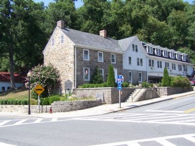
On Main Street (Maryland Route 222) at Center Street ( Route 276), on the right when traveling north on Main Street.
Born at this house at Creswell’s Ferry, now Port Deposit, in 1828, John Creswell graduated from Dickinson College and became a lawyer. He was elected to the General Assembly in 1861, became Adjutant General in 1862, was elected to Congress that . . . — — Map (db m145442) HM
On North East Road (Route 272) 0.3 miles north of Old Bayview Road, on the right when traveling north.
Built circa 1860, the bridge is one of the few covered ones left in Maryland and the only one on public ground in Cecil County. The area to the East has been the site of several mills, the earliest Samuel Gilpin’s flour mill circa 1735. . . . — — Map (db m1692) HM
On Bridge Street (Maryland Route 213) 0.1 miles north of Pulaski Highway (U.S. 40), on the right when traveling north.
Built c. 1810–1820 by James Sewall. He was Clerk of Cecil County Court 1805–1841; Brigade Major of Maryland Militia and a Commander at nearby Fort Defiance in War of 1812; one of founders of Trinity Episcopal Church, Elkton in 1832. — — Map (db m145435) HM
On East Main Street at Grooms Lane, on the left when traveling east on East Main Street.
Built in 1769 as the home of Dr. Abraham Mitchell, noted physician. During the Revolutionary War he converted the house into a hospital for the use of wounded soldiers of the Continental Army. General Lafayette was a friend of the Mitchell family . . . — — Map (db m154175) HM
On Brick Meeting House Road 0.2 miles west of Route 272, on the right when traveling west.
William Penn set aside lot no. 30 (500 acres) of the “Nottingham Lots” in 1702 for a “common” and site of a “meeting house” as a bold move in the boundary line dispute with Lord Baltimore. It has been continuously used since the first log meeting . . . — — Map (db m189238) HM
On Broad Street 0.1 miles west of River Road, on the right when traveling west.
Old Post Road
Established 1666
Lower Susquehanna Ferry
established 1695
Rodgers’ Tavern
where
George Washington
frequently stopped
between
1781–1798 — — Map (db m145429) HM
Near Richardson Avenue, on the left when traveling east.
Erected by the survivors of Company A & I to the memory of our fallen comrads who fell on this spot September 17, 1862. ———— This stone marks the extreme advance of Weber's Brigade French's Div. 2nd Army Corps . . . — — Map (db m17622) HM
Near Mid Atlantic Blvd.. Reported permanently removed.
Dinosaurs lived during most of the Mesozoic Era (235 to 65 million years ago), on every continent on Earth. In Maryland, each of three Mesozoic time periods in which dinosaurs live is represented in its geology -- Triassic, Jurassic, and . . . — — Map (db m67139) HM
On DE 896, DE 71 (Summit Bridge Road) 0.1 miles south of Victoria Drive, on the right when traveling south.
Approximate southern boundary of tract of thirty thousand acres granted by William Penn to the Welsh in 1701. It included what is now Pencader Hundred, Delaware, and a part of Cecil County, Maryland. — — Map (db m157102) HM
On Cayots Corner Road at St. Augustine Road, South, on the right when traveling east on Cayots Corner Road.
Still visible close by is the 20-foot square pre-1850 stone foundation for an historic school house. Rebuilt in 1880 at a cost of $488, this one room school was typical of those found in rural 19th century Cecil County. The Maryland State Teachers . . . — — Map (db m9663) HM
On Telegraph Road (Route 273) at Rock Church Road, on the left when traveling east on Telegraph Road.
Founded 1720 in North Milford Hundred, Cecil County, Maryland. First called New Erection on the Branches of Elk River, then Elk River Church, Great Elk, upper Elk and, since 1793, Rock. Present church erected 1761 remodeled in 1844 and 1900. — — Map (db m1764) HM
During the early 20th century, forest fires ravaged Maryland, impacting both people and wildlife, and costing uncalculated dollars worth of damage annually. Not only was marketable timber lost, but so were emerging sprouts and seedlings. Moreover, . . . — — Map (db m98506) HM
Near North Talbot Street at Dodson Avenue, on the right when traveling north.
Farm laborer's log house
Henrietta and Albert T. Wilson raised eight children in this log house located one mile south of Trappe, Maryland in the late 1800s. Albert was a farm overseer and laborer at the nearby Welsh farm. Later census . . . — — Map (db m285672) HM
This historic walk takes you to the Turkey Point Light Station in Maryland's Cecil County. You will find, atop a 100-foot-high bluff, an 1833 tapering conical stucco-covered brick tower and a 1913 cement oil house. This Lighthouse is 31_1/2 feet . . . — — Map (db m147628) HM
What is a Hundred?
A hundred is an old English subdivision of a county. Although the origin is somewhat shrouded in mystery, basically it was a tract of land large enough to provide a hundred men to serve the king’s wars. In American . . . — — Map (db m156915) HM
Welcome to Mount Harmon Plantation, one of Maryland’s premier historic sites. Comprising 200-acres of pristine open space, Mount Harmon features a restored 18th century manor house and plantation kitchen, a formal boxwood garden, a rare tobacco . . . — — Map (db m156564) HM
On North Center Street, on the right when traveling south.
Born 27 October 1804 in Cecil County, Maryland, the oldest son of Israel Evans and Abigail Alexander. Reared in Maryland and Pennsylvania, settling in Ohio to start a family. Baptized into the Church of Jesus Christ of Latter-day Saints, 1833; . . . — — Map (db m150060) HM
Near North Church Street (U.S. 13) at East 7th Street, on the right when traveling north.
1638: Peter Minuit with a crew of Dutch sailors and Swedish soldiers, landed the Kalmar Nyckel and the Fogel Grip at a natural outcropping of rocks on the Minquas Kill. They named the river and the fort they built for Sweden's Queen . . . — — Map (db m174888) HM
Mount Harmon offered a vantage point for events unfolding along the Sassafras May 6, 1813. Barges of British marines passed by en route to Georgetown and Fredericktown. As they returned, smoke rose in the skies behind them from the burning of . . . — — Map (db m156570) HM
On Broad Street (Maryland Route 7) at Roundhouse Drive, on the right when traveling west on Broad Street. Reported permanently removed.
On April 18-19, 1861, a week after the bombardment of Fort Sumter, South Carolina, Confederate sympathizers attacked U.S. Army forces en route to Washington in Baltimore, 35 miles southwest of here. On the second day shots were fired and soldiers . . . — — Map (db m145865) HM
On River Highway (North Carolina Route 150) at Mariner Pointe Lane, on the right when traveling west on River Highway.
Among the original pioneers from Pennsylvania, New Jersey, and Maryland who settled on the east side of the Catawba River were George Davidson (1-home destroyed), Reverend John Thomson, Moses White, Hugh Lawson, John Oliphant, John Brevard, . . . — — Map (db m283194) HM
On New Castle Avenue (Delaware Route 9), on the right when traveling north.
Built in 1667, Crane Hook Church was located one mile east of here on what is now Pigeon Point Road. The Church took its name from the land located between here and the Delaware River. Under Dutch leadership, this area was colonized by the Swedes . . . — — Map (db m67354) HM
On Bohemia Avenue, on the left when traveling north.
This tablet is dedicated by the people of Chesapeake City and the Second Election District of Cecil County, Maryland, to those of their number who offered their lives in defense of humanity in the Great War of Nations 1914 - 1918 Roll of Honor . . . — — Map (db m144823) HM
On Philadelphia Road (Maryland Route 7) 0.2 miles east of Jackson Station Road, on the right when traveling east.
After burning much of Havre de Grace May 3, 1813, British raiders crossed the Susquehanna to Cecil County. At Principio Iron Works they captured a five-gun battery and destroyed the foundry complex and the bridge across Principio Creek. More than 40 . . . — — Map (db m145868) HM
On Tidal Court at Coastal Way, on the left when traveling west on Tidal Court.
The remains before you and the surrounding property originally belonged to Richard Barry (1726-1815). The Barry family probably settled here in the 1750's after spending a generation in Cecil County, Maryland. Richard was the first tanner in the . . . — — Map (db m239584) HM
On East Main Street 0.1 miles east of Western Avenue, on the right when traveling east.
Born in Cecil County, Maryland, William Alexander entered the Revolutionary War from Rowan County, North Carolina in 1775. Wounded in 1776, he later joined a South Carolina unit and fought at Cowpens, Fort Motte, Granby, Biggers Church, and . . . — — Map (db m248916) HM
On Dayett Mills Road south of Old Baltimore Pike, on the right when traveling south.
What is a Hundred?
A hundred is an old English subdivision of a county. Although the origin is somewhat shrouded in mystery [,] basically it was a tract of land large enough to provide a hundred men to serve in the king’s wars. In American . . . — — Map (db m156916) HM
Valentine Hollingsworth and 2nd wife, Anne Calvert, came to this country in 1682 about the same time as William Penn. He was the father of 11 children and lived in northern Delaware in the area now called Brandywine Hundred.
Son Henry . . . — — Map (db m96587) HM
On Pennington Avenue west of North Lodge, on the right when traveling east. Reported permanently removed.
Cannon and rocket fire shook residents of Havre de Grace from their sleep as the British attacked at dawn May 3, 1813. An eyewitness reported: "Distressed people, women and children half naked" ran from their homes. The local militia fled, . . . — — Map (db m311985) HM
On Courthouse Road (County Route 630), on the left.
The Principio Company constructed the Accokeek Iron Furnace nearby about 1726 on land leased from Augustine Washington (father of George Washington), who became a partner. After Washington’s death in 1743, his son Lawrence inherited his interest in . . . — — Map (db m2261) HM
On W. Main Street (Maryland Route 282) west of Bohemia Avenue ( Route 213), on the right when traveling west. Reported permanently removed.
The town of Cecilton owes its existence to Augustine Herman, a 1633 immigrant to America. A wealthy merchant, diplomat, cartographer, and explorer, he also proposed the creation of the Chesapeake and Delaware Canal a century before it was . . . — — Map (db m155453) HM
Colonial Tobacco Trade Before you stands a crop of tobacco planted to reflect the historic tobacco trade that flourished at Mount Harmon in the colonial era. Tobacco was an important cash crop that helped build early American settlements, and . . . — — Map (db m156568) HM
What is iron ore?
Iron is a silvery-white, solid metal, though when found in Pencader Hundred, it commonly appears as a brown and sometimes nearly black oxide of iron. Its chemical symbol Fe, is derived from ferrum, the Latin word for iron. . . . — — Map (db m140211) HM
Historic Roads of Newark, Delaware
1. Old Baltimore Pike
The Old Baltimore Pike was built before 1720 and connected Elkton, Maryland to Christiana. It followed the path of an east-west Indian trail over the south side of Iron Hill. . . . — — Map (db m214020) HM
On Crownsville Road, on the right when traveling north.
Civil Rights, the evolution of mental health care and the push for racial equality transformed Crownsville Hospital in the 1960s and 70s. Community activism improved conditions throughout the hospital, and civil rights rulings led to the integration . . . — — Map (db m279576) HM
Near Key Highway east of Boyle Street, on the right when traveling west.
Steam Tug Baltimore was built at the foot of Federal Hill, at a cost of approximately $30,000. S.T. Baltimore served the city from 1906 to 1962. In 1963, Maryland Shipbuilding and Dry Dock sold the Baltimore to family in . . . — — Map (db m131180) HM
On School House Lane, on the right when traveling west.
Erected to honor the heroism of the men who so bravely defended Fort Duffy and Fredericktown against the British Fleet May 5, 1813 Colonel Thomas Ward Veazey, commanding
Samuel Wroth; D.F. Heath; Moses Cannon; Nicholas Franks; John W. . . . — — Map (db m155571) WM
On Broad Street at Roundhouse Drive, on the right when traveling west on Broad Street.
On April 18-19, 1861, a week after the bombardment of Fort Sumter in Charleston, S.C., Confederate sympathizers attacked U.S. Army forces en route to Washington in Baltimore, 35 miles southwest of here.
On the second day, shots were fired . . . — — Map (db m304314) HM
On Pulaski Highway (U.S. 40) east of South College Avenue (Delaware Route 896) when traveling west.
Welsh Tract Church
William Penn granted a 30,000 acre tract of land to three Welshmen, (David Evans, William Davis, and William Willis) in 1701. They and their followers had left southern Wales in search of religious freedom. In encouraging . . . — — Map (db m238425) HM
Welsh Tract Church
William Penn granted a 30,000 acre tract of land to three Welshmen, (David Evans, William Davis, and William Willis) in 1701. They and their followers had left southern Wales in search of religious freedom. In encouraging . . . — — Map (db m140189) HM
Near South Old Baltimore Pike west of Iron Hill Road, on the right when traveling west.
Welsh Tract Church
William Penn granted a 30,000 acre tract of land to three Welshmen, (David Evans, William Davis, and William Willis) in 1701. They and their followers had left southern Wales in search of religious freedom. In encouraging . . . — — Map (db m238421) HM
On Dayett Mills Road south of Old Baltimore Pike, on the right when traveling south. Reported permanently removed.
What is iron ore?
Iron is a silvery-white, solid metal, though when found in Pencader Hundred, it commonly appears as a brown, and sometimes nearly black oxide of iron. Its chemical symbol Fe, is derived from ferrum, the Latin word . . . — — Map (db m157343) HM
On Robert L. Melson Lane near Whitaker Road, on the left when traveling north.
[caption:] Iron ore like this was mined from Iron Hill and Chestnut Hill
What is iron ore?
Iron is a silvery-white, solid metal, though when found in Pencader Hundred, it commonly appears as a brown, and sometimes nearly black . . . — — Map (db m158219) HM
On Dayett Mills Road near Old Baltimore Pike, on the right when traveling south.
Welsh Tract Church
William Penn granted a 30,000 acre tract of land to three Welshmen, (David Evans, William Davis, and William Willis) in 1701. They and their followers had left southern Wales in search of religious . . . — — Map (db m156971) HM
Thin black lines indicate changes in relevance. Between each pair of lines entries are ordered geographically but all have the same relevance.
* Inflectional forms of words are their plurals, singulars, and possessives as well as gramatical tenses and similar variations.