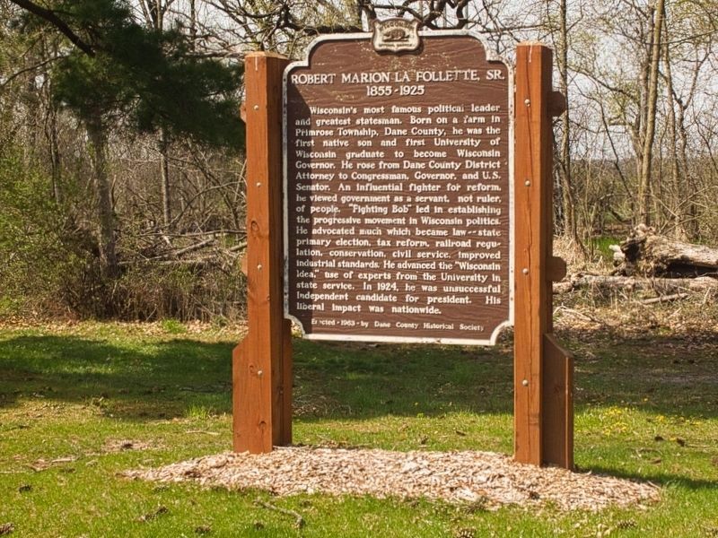
On Williams Drive 0.3 miles north of River Drive, on the left when traveling north.
Wisconsin's most famous political leader and greatest statesman. Born on a farm in Primrose Township, Dane County, he was the first native son and first University of Wisconsin graduate to become Wisconsin Governor. He rose from Dane County . . . — — Map (db m207173) HM
Near Observatory Drive, on the right when traveling west.
Born of Norwegian parents in town of Albion, January 12, 1846 Member of the University faculty 1869-1883 United States Minister to Denmark 1885-1889 Died in Madison, Wisconsin, March 2, 1936 First Wisconsin-born professor on the University faculty . . . — — Map (db m32739) HM
On Moorland Road, on the right when traveling east.
Across Moorland Road is a 140-acre wetland. Once a storage lagoon for treated wastewater solids produced at the Nine Springs Wastewater Treatment Plant, the area is now one of the most important shorebird viewing sites in Dane County. We invite . . . — — Map (db m292890) HM
Near Moorland Road, on the right when traveling east.
Metro Madison E-Way Features and Icons
· Lake Monona
· Chazen art museum
· Camp Randall memorial arch
· Wisconsin state capitol
· Lakeshore Nature Preserve
· Curtis prairie, UW Arboretum
· Monona Terrace
· Capital City . . . — — Map (db m293985) HM
On Martin Luther King, Jr. Boulevard at East Wilson Street, on the right when traveling south on Martin Luther King, Jr. Boulevard. Reported missing.
At least 887 earthen Indian mounds once dotted the land around lakes Mendota, Monona, Wingra, Waubesa, and Kegonsa—so many that archaeologist Charles E. Brown once suggested Madison be renamed Mound City. Most southern Wisconsin mounds were . . . — — Map (db m35551) HM
On East Main Street (State Highway 113) 0.1 miles west of 2nd Street, on the right when traveling west.
Dane County was created by the Wisconsin Territorial Legislature in 1836. Judge James Doty had convinced the Legislature to select Madison as the Capital and name the surrounding county in honor of Nathan Dane, a compiler of the Ordinance of 1787, . . . — — Map (db m37643) HM
On King Street 0.1 miles east of South Webster Street, on the left when traveling east.
Once located here, Peck Cabin -- Madison's first residence, business and post office -- was built by entrepreneurs Ebenezer and Roseline Peck in 1837. Constructing their cabin with adjoining additions near the new territorial capitol site, the Pecks . . . — — Map (db m31701) HM
Near State Highway 19 at Matz Road, on the left when traveling west.
On the brow of a hill, one-half mile east overlooking Indian Lake, rests a tiny stone chapel. The structure was built in 1857 by John Endres in fulfillment of a religious vow he made in return for protecting the lives of his family during a . . . — — Map (db m31809) HM
Born in Dane County, Wisconsin, October 20th, 1857, he graduated from Galesville College and in 1882 from the Law School of the University of Wisconsin and came to Leola, McPherson County, Dakota. He was elected Register of Deeds and County Clerk at . . . — — Map (db m182238) HM
On West Washington Avenue at South Carroll Street, on the right when traveling east on West Washington Avenue.
Sometime between 14,000 and 20,000 years ago, during the Ice Age, an enormous northern glacier invaded Wisconsin. Standing here then, you would have been encased in a solid ocean of ice 160 stories tall. The glacier bulldozed this area’s jagged . . . — — Map (db m32914) HM
Near Fish Camp Road 0.3 miles east of County Highway AB, on the right when traveling east.
Large carp populations provided constant work for Fish Camp crews. While the camp supervisor arranged carp sales to local businesses and commercial markets, the foreman and crewmembers seined fish in Dane County lakes. Lakes Kegonsa and Waubesa were . . . — — Map (db m48400) HM
On County Route Y 3 miles County Route M, on the left when traveling north. Reported missing.
Blackhawk Memorial Park is on the site of the Battle of Pecatonica, the first of three military engagements fought in present-day Wisconsin during the American-Indian conflict of 1832, known as the Black Hawk War. On June 16, 1832, following . . . — — Map (db m262388) HM
Near Lorillard Court at Findorff Court, on the right when traveling east.
These two buildings are the most substantial warehouses built in Madison to house the processing of leaf tobacco. From the Civil War until the 1940s, leaf tobacco was among Dane County's most lucrative crops. The tobacco grown in Wisconsin was . . . — — Map (db m53072) HM
On County Highway G at Oak Grove Road, on the left when traveling south on County Highway G.
Side 1
Among early Primrose settlers were six La Follette brothers from Indiana. One of them, Josiah, and his wife Mary, arrived in 1850 and acquired acreage in section 18, three miles south of this site. Josiah held town offices, including town . . . — — Map (db m116818) HM
On Campus Lane north of Edgerton Road, on the left when traveling north.
The Sheepskin School was build on Wisconsin Highway 59 just west of Edgerton in District 6, Fulton Township, Rock County. One theory for its name is from sheep "skins" drying on a nearby fence. The 1894-95 Attendance Book lists 31 students, but . . . — — Map (db m167644) HM
Near County Route F 0.8 miles north of Cave of the Mounds Road, on the right when traveling north.
Ebenezer Brigham (1789-1861), first permanent white settler of Dane County, came here as a prospector in 1828. The inn he built for his miners became popular with travelers on the old Military Road, and Blue Mounds became a well-known landmark. . . . — — Map (db m224706) HM
On Dunroven Road at County Road DM, on the right when traveling south on Dunroven Road.
In July, 1833, Lt. Alexander Center blazed a nearby oak, marking the 100-mile point of a military road he and James Doty were surveying. The Old Military Road, built from 1835 to 1837, connected Ft. Crawford at Prairie du Chien, Ft. Winnebago at . . . — — Map (db m36907) HM
On the Capitol City Trail 0.5 miles west of Lake Farm Road, on the left when traveling west.
Gilman Mounds
Image credits Top Wisconsin Historical Society WHS-95142. Center WHS-58453. Bottom left Jim Welsh. Bottom center WHS-51985. Bottom right WHS-26882.
A damaged mound . . . — — Map (db m304707) HM
On the Capitol City Trail 0.5 miles west of Lake Farm Road, on the left when traveling west.
Madison's Ancient Moundscape
Mound builders began constructing mounds 2,700 years ago in Wisconsin and built about 20,000. 4,000 remain. The Madison area–rich in lakes, wetlands, and savanna-covered ridges—was dense with mounds. Out of . . . — — Map (db m307448) HM
Near Parkside Drive north of East Washington Avenue (U.S. 151), on the left when traveling north.
The land for this park, with the triangular retreat across Highway 151 and Sunnyside School nearby, was given by Amund K. Reindahl (1869-1946) farmer-owner. A University of Wisconsin graduate and Dane County Register of Deeds, Reindahl bought the . . . — — Map (db m274094) HM
Near Fish Camp Road 0.4 miles east of County Highway AB, on the right when traveling east.
From 1881 to 1896, the state Fish Commission stocked about 100,000 common carp in 67 Wisconsin counties. Other states also introduced carp, but the fish thrived in the slow, shallow, weedy lakes of Dane County. Carp quickly became so abundant that . . . — — Map (db m48401) HM
Near North Mechanic Street just north of West Day Spring Lane, on the left when traveling north.
Overview The Homestead Act of 1862 made government land taken from Native Americans available for free if it was used for five years. This law allowed millions of European immigrants to settle in the prairies and woodlands of the central . . . — — Map (db m236673) HM
Near Scherbel Road, on the right when traveling north.
You are looking across a deep preglacial valley. Once glacial meltwaters drained west to the Wisconsin River, depositing sand and gravel brought south to Middleton by the giant ice sheets. Today, winding through this unglaciated outwash plain is . . . — — Map (db m36988) HM
On West Wilson Street at South Hamilton Street, on the right when traveling west on West Wilson Street.
Dane County was created by the Wisconsin Territorial Legislature in 1836. Judge James Doty had convinced the Legislature to select Madison as the Capital and name the surrounding county in honor of Nathan Dane, a compiler of the Ordinance of 1787, . . . — — Map (db m37611) HM
On Mineral Point Road at Junction Road, on the right when traveling west on Mineral Point Road.
This immediate area was the site of the first Middleton, settled shortly after Dane County was formed. Early settlers Harry Barnes and his father, Joe, were captains in the Civil War. Harry suggested that the area be called Middletown, after his . . . — — Map (db m66113) HM
Near Mounds Road/ Park Entrance Road 1.5 miles north of County Road Id (County Route Id).
In the late hours of November 25, 1944, a C-47 Army cargo plane en route from Chicago to Minneapolis crashed into Blue Mound 400-500 feet north of this monument. The plane had encountered a winter storm, and burdened by built up ice, was attempting . . . — — Map (db m73004) HM WM
On Moorland Road 0.3 miles east of Raywood Road, on the right when traveling east.
The Lewis Nine Springs E-Way
The original vision for the Nine Springs E-Way began in 1970 as a demonstration project funded by the National Endowment of the Arts. In 1971, Dane County adopted the "Environmental Loop Plan". After a series of . . . — — Map (db m276714) HM
Near Burrows Road 0.1 miles west of Sherman Avenue, on the left when traveling west.
This mound was constructed by people of a hunting and gathering culture who met periodically at ceremonial grounds like this one to bury their dead. — — Map (db m33532) HM
Near Femrite Drive at Edna Taylor Parkway, on the left when traveling east.
Edna E.E. Taylor was a teacher, writer and, in her later years, a dairy farmer. A believer in "Sensible Ecology" she proposed to sell 37 of her 98 acres of land to the city of Madison. Added to 10 adjacent acres already held by the city and 11 acres . . . — — Map (db m33322) HM
On Edgewood Drive 0.1 miles west of Edgewood Avenue, on the right when traveling west.
To the native peoples who lived here, this water spirit represented the god of the underworld and has both spiritual and environmental significance. — — Map (db m33514) HM
Near Lakeland Avenue at Maple Avenue, on the right when traveling east.
These mounds were constructed by a people of a hunting and gathering culture who met periodically at ceremonial grounds like this one to bury their dead. — — Map (db m33501) HM
Near Lakeland Avenue at Hudson Avenue, on the right when traveling east.
These mounds were constructed by a people of a hunting and gathering culture who met periodically at ceremonial grounds like this one to bury their dead. — — Map (db m33503) HM
Near North Henry Street at West Gilman Street, on the left when traveling north.
The house of Judge Arthur B. Braley was a social and cultural center of the Mansion Hill area in the Nineteenth Century. The house was built of cream brick with incised stone lintels in the Late Gothic Revival style. Braley, a patron of the literary . . . — — Map (db m33723) HM
On Erin Street at Wingra Street, on the left when traveling west on Erin Street.
One of the several groups of prehistoric burial, linear and effigy mounds formerly located on the crest of the Monona-Wingra ridge. Several of these were surveyed by Increase A. Lapham, in 1850. Village site was in the park below. Marked for the . . . — — Map (db m36955) HM
On East Main Street (U.S. 51) east of Forrest Street, on the right when traveling west.
The greater Stoughton area was hunted and trapped by the Ho-Chunk Nation and other Native American tribes through the 1700's. Surveyed in 1833, the Stoughton area was described as being populated with timber and carpeted with prairie along the . . . — — Map (db m274503) HM