49 entries match your criteria.
Entries Containing All of the Phrases «clay county» AND «missouri»
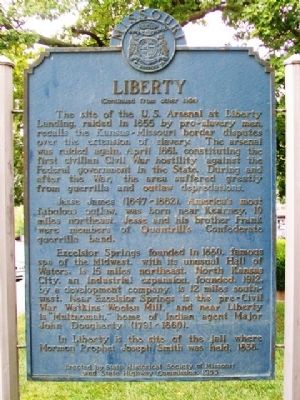
By William Fischer, Jr., July 30, 2013
Liberty Marker (back)
RANKED BY RELEVANCE
1 ► Missouri, Clay County, Liberty — Liberty —  |
| On Water Street north of Kansas Street, on the left when traveling north. | |||
| 2 ► Missouri, Clay County, Liberty — Faces of the Commonwealth — |
| On Water Street north of Mill Street, on the left when traveling north. | |||
| 3 ► Missouri, Clay County, Liberty — 3 — Veterans — Liberty African American Legacy Memorial — |
| Near West Shrader Street west of Gallatin Street, on the right when traveling east. | |||
| 4 ► Missouri, Clay County, Liberty — Clay County Courthouse — |
| On Kansas Street at Main Street, on the left when traveling east on Kansas Street. | |||
| 5 ► Missouri, Clay County, Liberty — First Court House Site — Clay County Historical Society Historic Landmark — |
| On Water Street north of Mill Street, on the left when traveling north. | |||
| 6 ► Missouri, Clay County, Liberty — Jurisprudence — |
| Near South Water Street. | |||
| 7 ► Missouri, Clay County, Kearney — Watkins Mill — Clay County Historical Society Historic Landmark — |
| Near Watkins Road 1 mile south of County Road MM. | |||
| 8 ► Missouri, Clay County, Liberty — Lightburne Hall — Clay County Historical Society Historic Landmark — |
| On North Water Street 0.1 miles north of East Mississippi Street, on the right when traveling north. | |||
| 9 ► Missouri, Clay County, Liberty — Riverview — Clay County Historical Society — Historic Landmark — |
| On Crawford Lane at North Grover Street on Crawford Lane. | |||
| 10 ► Missouri, Clay County, Liberty — 54 — Garrison School — |
| On North Water Street 0.2 miles north of East/West Mississippi Street when traveling north. | |||
| 11 ► Missouri, Clay County, Liberty — Monument to the Eight Witnesses — |
| On Campbell Drive south of South Liberty Parkway, on the right when traveling south. | |||
| 12 ► Missouri, Clay County, Liberty — Founding Fathers — |
| Near South Water Street. | |||
| 13 ► Missouri, Clay County, Gladstone — 36 — Atkins-Johnson Farm — |
| Near Northeast Pleasant Valley Road east of Northeast Antioch Road, on the right when traveling east. | |||
| 14 ► Missouri, Clay County, Liberty — The Liberty Landing — |
| Near Old Missouri 210 0.5 miles east of Missouri Hiway 291. | |||
| 15 ► Missouri, Clay County, Liberty — The Liberty, Missouri Juneteenth Legacy — |
| On Grover Street south of Corbin Street, on the right when traveling south. | |||
| 16 ► Missouri, Platte County, Parkville — Attack on the Paw Paw Fort — Missouri's Civil War 1861 - 1865 — The Struggle for Platte County |
| On NW River Park Drive (Missouri Route 9) 0.1 miles east of East Street, on the right when traveling east. Reported permanently removed. | |||
| 17 ► Missouri, Clay County, Liberty — 8 — Teachers and Educators — Liberty African American Legacy Memorial — |
| On West Shrader Street west of Gallatin Street, on the right when traveling east. | |||
| 18 ► Missouri, Clay County, Liberty — 4 — Business Owners — Liberty African American Legacy Memorial — |
| Near West Shrader Street west of Gallatin Street, on the right when traveling east. | |||
| 19 ► Missouri, Clay County, Liberty — 7 — Reconstruction, Great Migration and Civil Rights Eras — Liberty African American Legacy Memorial — |
| On West Shrader Street west of Gallatin Street, on the right when traveling east. | |||
| 20 ► Missouri, Clay County, Liberty — "The Old Graveyard" — "Mt. Memorial Cemetery" — |
| On Miller Avenue at William Jewell College Drive, on the right when traveling west on Miller Avenue. | |||
| 21 ► Missouri, Jackson County, Kansas City, South Kansas City — Alexander Doniphan — General and Politician — |
| On East Red Bridge Road, on the right when traveling west. | |||
| 22 ► Missouri, Caldwell County, Kingston — Kingston — |
| On East Main Street just east of North Washington Street ( Highway 13). | |||
| 23 ► Missouri, Clay County, Liberty — Doniphan – Hubbell House — |
| On Main Street 0.1 miles south of East Mississippi Street, on the right when traveling south. | |||
| 24 ► Missouri, Clay County, Liberty — Battle of Liberty / Blue Mills Landing — |
| On Southview Drive at Ruth Ewing Road, on the left when traveling south on Southview Drive. | |||
| 25 ► Missouri, Clay County, Liberty — 38 — Liberty Arsenal — |
| On Southview Drive south of Seven Hills Road, on the left when traveling south. | |||
| 26 ► Missouri, Clay County, Liberty — 6 — Pioneer Families — Liberty African American Legacy Memorial — |
| On West Shrader Street west of Gallatin Street, on the left when traveling west. | |||
| 27 ► Missouri, Clay County, Liberty — The Lewis and Clark Expedition Across Missouri — |
| On Old Missouri 210 0.5 miles east of Missouri Highway 291. | |||
| 28 ► South Dakota, Union County, Elk Point — Lewis & Clark Campsite / Eli Wixson Farm Site — |
| On S. Harrison St. 0.2 miles west of W. Jefferson, in the median. | |||
| 29 ► Georgia, Randolph County, Cuthbert — 120-9 — Randolph County — |
| On Court Street (Business U.S. 27) at Pine Street, on the left when traveling north on Court Street. | |||
| 30 ► Missouri, Clay County, Kansas City, Antioch Acres — Antioch Church — |
| On NE Antioch Road (Missouri Route 1) at NE 48th Street, on the right when traveling north on NE Antioch Road. | |||
| 31 ► Missouri, Clay County, Liberty — 2 — Forging a Community — Liberty African American Legacy Memorial — |
| On West Shrader St west of Gallatin Street, on the right when traveling east. | |||
| 32 ► Missouri, Platte County, Kansas City, Barry — 47 — The Town of Barry |
| Near Northwest 87th Terrace east of Northwest 88th Street/Northwest Old Stagecoach Rd, on the left when traveling east. Reported missing. | |||
| 33 ► South Dakota, Union County, Vermillion — 483 — Homestead Rest Area — |
| Near Interstate 29 at milepost 26 at State Route 50. | |||
| 34 ► Texas, Clay County, Henrietta — 25 — 1890 Clay County Jail — |
| On West Ikard Street east of North Graham Street, on the right when traveling east. | |||
| 35 ► Arkansas, Clay County, Rector — Scatterville — |
| On County Road 430 0.1 miles east of County Road 418, on the right when traveling east. | |||
| 36 ► Missouri, Clay County, Liberty — 5 — Antebellum Era — Liberty African American Legacy Memorial — |
| Near West Shrader Street west of Gallatin Strret, on the left when traveling west. | |||
| 37 ► Missouri, Franklin County, Stanton — Saltpeter Cave — Missouri's Civil War — |
| Near Highway West (State Highway W), on the right. | |||
| 38 ► Utah, Weber County, Liberty — 328 — Liberty — |
| Near East 4100 North just east of North 3500 East, on the right when traveling east. | |||
| 39 ► Arkansas, Phillips County, West Helena — Early Railroads — |
| On Plaza Avenue 0.1 miles east of U.S. 49, on the left when traveling east. | |||
| 40 ► Florida, Clay County, Middleburg — F-840 — General Roy Stanley Geiger, United States Marine Corps — |
| On Blanding Boulevard (Florida Route 21) west of Parsonage Street, on the right when traveling east. | |||
| 41 ► Missouri, Clay County, Liberty — Lewis and Clark Mural — Dedicated June 24, 2005 — Artist: David McClain — |
| On Water Street at Mill Street, on the left when traveling north on Water Street. | |||
| 42 ► Missouri, Clay County, North Kansas City — Curran Park — |
| On Swift Avenue at 18th Avenue, on the right when traveling south on Swift Avenue. | |||
| 43 ► Missouri, Jackson County, Kansas City, South Kansas City — People and the Trails — Santa Fe, Oregon and California National Historic Trails — |
| On East Red Bridge Road, on the right when traveling west. | |||
| 44 ► Nebraska, Clay County, Harvard — 191 — Harvard — |
| On East Walnut Street 0.1 miles west of Airport Road, on the right when traveling west. | |||
| 45 ► Missouri, Clay County, Gladstone — 24 — Historic Linden, Missouri — |
| On North Campbell Street at Northeast 69th Street, on the right when traveling south on North Campbell Street. | |||
| 46 ► Missouri, Clay County, Gladstone — 25 — Old Pike Road / Ferry Boat Operators at Kawsmouth — |
| On Northwest Old Pike Road at Northwest 51st Street, on the right when traveling south on Northwest Old Pike Road. | |||
| 47 ► Missouri, Clay County, Liberty — 1 — Cemeteries, Burials and Fairview — Liberty African American Legacy Memorial — |
| On West Shrader Street west of Gallatin Street, on the right when traveling east. | |||
| 48 ► Missouri, Clay County, Liberty — Martha Lafite Thompson Nature Sanctuary — McGowan Interurban Railway Bridge and Passenger Station — Interurban RR Trail — |
| Near North La Frenz Road north of Mary Lane, on the right when traveling north. | |||
| 49 ► Missouri, Clay County, Smithville — Flood of 1965 High Water Mark — |
| On Bridge Street north of Main Street, on the left when traveling north. | |||
Thin black lines indicate changes in relevance. Between each pair of lines entries are ordered geographically but all have the same relevance.
* Inflectional forms of words are their plurals, singulars, and possessives as well as gramatical tenses and similar variations.
Nov. 12, 2026