By Ginger Drenning, August 26, 2009
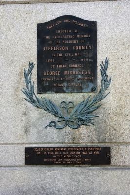
Full View - - Civil War Memorial Marker & Rededication Plaque
RANKED BY RELEVANCE
On East Main Street west of Walnut Street, on the right when traveling east.
On East Main Street (U.S. 421) at Jefferson Street, on the right when traveling east on East Main Street.
Near Michigan Road just south of East State Street, on the left when traveling south.
Near Jefferson Street south of East Main Street (Ohio Scenic River Byway) (U.S. 421), on the left when traveling south.
On Cragmont Street north of Presbyterian Avenue, on the right when traveling north.
On Ohio River Scenic Byway (State Road 56) at South Eagle Hollow Road, on the right when traveling west on Ohio River Scenic Byway.
On West Vaughn Drive just east of Central Avenue, on the right when traveling east.
On West 1st Street just west of Vine Street, on the left when traveling west.
On West Main Street at McIntire Street, on the right when traveling west on West Main Street.
On Jackson Street (State Road 7) east of North Pike Street, on the left when traveling east.
On North Pike Street north of Jackson Street, on the left when traveling north.
On Harlan Street south of East Fairground Avenue, on the right when traveling south.
On Jefferson Street (U.S. 421) at 5th Street, on the right when traveling north on Jefferson Street.
On South Buckeye Street (U.S. 421) at Washington Street, on the right when traveling south on South Buckeye Street.
On West Main Street (State Road 256) at South Rogers Road, on the right when traveling east on West Main Street.
Paid Advertisement
On Ohio Route 164 south of Local Road 263, on the left when traveling north.
Near County Route 49 0.1 miles west of Route 164, on the left when traveling west.
On Ohio Route 150 0.1 miles west of Main Street, on the right when traveling east.
On Dry Fork Road (County Highway 8) at State Route 150, on the right when traveling north on Dry Fork Road.
On Ohio Route 43 at Mill Street, on the left when traveling east on Ohio Route 43.
On Green Street at East Main Street (U.S. 250), on the right when traveling east on Green Street.
On Ohio Route 164 at County Road 55, on the left when traveling east on Ohio Route 164.
On County Highway 74 at Local Highway 166, on the left when traveling east on County Highway 74. Reported missing.
On New Alexandria Road (Ohio Route 151) at Chappel Hill Road (Local Highway 184), on the right when traveling west on New Alexandria Road.
On Local Highway 166 0.5 miles north of County Highway 74, on the left when traveling north.
On East Main Street (Ohio Route 43) at Route 152, on the left when traveling east on East Main Street.
On Main Street (Ohio Route 152) 0.2 miles south of Route 151, on the left when traveling north.
On Canton Road (Ohio Route 43) 0.2 miles north of U.S. 22, on the right when traveling south.
On Main Street (Ohio Route 43) at Fernwood Road, on the right when traveling east on Main Street.
On Westport Road (Kentucky Route 524) at 4th Street, on the right when traveling west on Westport Road.
On Trail #7 east of State Park Drive, on the right when traveling east.
Paid Advertisement
On West 3rd Street at Mill Street, on the right when traveling west on West 3rd Street.
On Mansfield Drive (U.S. 250) at North Main Street (U.S. 250), on the right when traveling east on Mansfield Drive. Reported permanently removed.
On Canyon Road at Clifty Hollow Road, on the right when traveling north on Canyon Road.
On West Main Street (Ohio River Scenic Byway) (Indiana Route 56) at Broadway Street, on the right when traveling west on West Main Street (Ohio River Scenic Byway).
Near E. Market Street 0.2 miles S. Allen Street.
Near Beechland Road (Kentucky Route 438) at Lincoln Park Road ( Route 528), on the left when traveling east.
On Ayres Avenue at Wheatfield Road, on the left when traveling south on Ayres Avenue.
On Ayres Avenue, on the right when traveling south.
On 4th Street north of Olive Avenue, on the left when traveling north.
On West Main Street west of South 1st Avenue, on the right when traveling east.
On Grandview Avenue, on the left when traveling east.
On W Main Street 0.2 miles north of Place Montpellier, on the right when traveling west.
Near Beechland Road (Kentucky Route 438) at Lincoln Park Road ( Route 528), on the left when traveling east.
Paid Advertisement
On East Union Street at Merchants Alley, on the right when traveling west on East Union Street.
︽
Thin black lines indicate changes in relevance. Between each pair of lines entries are ordered geographically but all have the same relevance. * Inflectional forms of words are their plurals, singulars, and possessives as well as gramatical tenses and similar variations.
Nov. 12, 2026