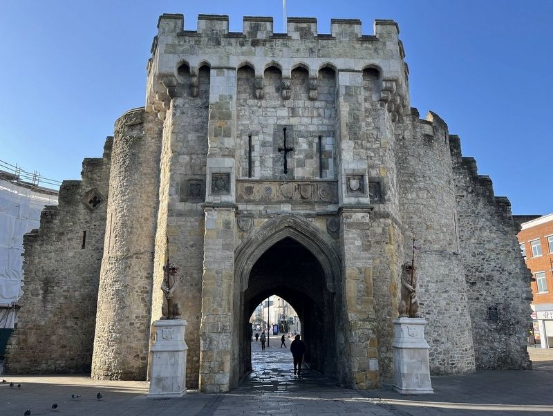
During the 12th Century this northern gateway to the medieval town was a single round archway. In the 13th Century two round towers were added and early in the 15th Century the north front was extended.
The guildhall now a museum was formerly . . . — — Map (db m279263) HM
Blue Anchor Lane was used to take imported goods from the quayside into the medieval town and the market at St. Michael's Square. The stone arch forms part of the town walls. The portcullis slot is still visible.
In the 1330s, Blue Anchor Lane . . . — — Map (db m272764) HM
The remains of the drum towers flanking the principal gateway to Southampton's medieval castle were discovered through archaeological excavations in 1961. The castle itself formerly stood on the site now occupied by a 20th century block of twelve . . . — — Map (db m279210) HM
Wealthy merchants lived in Cuckoo Lane during the 1200s. After the French Raid of 1338 their waterfront properties. were demolished to make way for the town walls. The area became gardens with a narrow lane running through it. Shakespeare's patron, . . . — — Map (db m279207) HM
The Bargate, built about 1180, kept out intruders and impressed visitors. Any strangers left beyond the barred gates at night could find food and shelter in the inns along Above Bar Street.
Southampton had a team of gunners to defend the town . . . — — Map (db m272760) HM
In the spring of 1783, at the age of seven, Jane, her sister Cassandra and their cousin Jane Cooper, attended a school nearby run by Mrs Ann Cawley. The exact location of this school is unknown. An outbreak of typhus closed the school after only a . . . — — Map (db m272666) HM
Jane's niece, fourteen-year old Fanny Knight, records in her diary of Tuesday, 15 September 1807, that Jane and the rest of the family embarked from here to visit friends in Hythe for afternoon tea. Fanny writes, 'Mama to everybody's astonishment . . . — — Map (db m272667) HM
The Mayflower Memorial is also known as the Pilgrim Fathers' Memorial. It was built in 1913 to commemorate the departure of 'the little company of Pilgrim Fathers who were destined to be the founders of the New England States of America' . . . — — Map (db m272709) HM
On the 15th of August, 1620, from the west quay near this spot, the famous Mayflower began her voyage, carrying the little company of pilgrim fathers, who were destined to be the founders of the New England States of America.
On the 15th of . . . — — Map (db m272739) HM
Southampton is a gateway city. People from all over the world have shaped its economy, culture and politics.
Roman, Saxon and Norman invaders and settlers all made their mark on the town in its first 1,300 years. Italian merchants and seafarers . . . — — Map (db m272710) HM
Southampton City Council has produced a development brief for this site to guide future residential development. As part of the site evaluation they funded an archaeological excavation during 1992 which revealed evidence of three medieval houses. . . . — — Map (db m279224) HM
This boat is a replica of a type of medieval trading ship known as a KEEL (1200 to 1400), a clinker-built boat, based on Viking shipbuilding techniques and thought to be the type used to take wool to Calais, then bring wine back from Bordeaux. . . . — — Map (db m272765) HM
During the 1939-45 war, Southampton suffered great damage from repeated air attacks. The worst raids were on the nights of 30th November & 1st December 1940. The Town Centre was virtually destroyed.
630 Citizens died, nearly 1900 were injured, . . . — — Map (db m279213) HM
Medieval boats were built with overlapping split boards, known as clinker construction. Towards the end of the medieval period European boat builders changed to sawn planks laid edge to edge; known as carvel-construction, a method that had been used . . . — — Map (db m279222) HM
In medieval times, St. Michael's Square was a busy fish market selling freshly caught eels, mackerel, whiting and oysters. The Cloth Hall was built about 1400. Wool was sold on the top floor and fish mongers traded beneath. In 1634, the hall was . . . — — Map (db m272628) HM
This is the oldest building in Southampton and dates from 1070 when the Norman town was being built. It was the civic church until 1835 where the mayors of the town were sworn in at Michaelmas.
Of the parish churches in the centre of the town . . . — — Map (db m279267) HM
Under this shelter roof lie the remains of the cellars in which some of Southampton's wealthy medieval mayors once stored their wine. The favourite drink of the English people in the medieval period was claret, a strong red wine made in the Bordeaux . . . — — Map (db m272780) HM
After the French attacked Southampton in 1338, King Edward Ill commanded a huge wall be built around the town, overlooking the sea. He was furious that the town's people had allowed the raiders to so easily attack and steal his wine and goods. . . . — — Map (db m272768) HM
In a cellar near this place, Walter Taylor (died-1758) and his son Walter (1734-1803) developed inventions of great importance to the Royal Navy between the years 1750 and 1758.
They were probably the first manufacturers to guarantee . . . — — Map (db m279208) HM
In 1476, Italian ships tied up at Town Quay to unload wines, fruits, spices and silks from the Mediterranean. The Watergate thronged with the voices of foreign sailors passing through the main entrance into the town.
William Soper worked as the . . . — — Map (db m279177) HM
Built after the French raid of 1338, the Westgate defended the entrance to the west quay which had been established in the Norman period. The portcullis grooves and murder holes above may still be seen. The tower above was designed to take guns. . . . — — Map (db m279176) HM
The Westgate was built after the French Raid of 1338, and was an important entrance into the medieval town. It was thought that in 1415 Henry V and his army departed through Westgate on their way to victory at Agincourt.
The sailors and . . . — — Map (db m279179) HM
Before 1847 and the coming of the railway, Blechynden Terrace was a secluded suburban terrace with ornamental gardens and a marine parade. The promenade along West Bay was so popular at weekends that there was no room to sit down at high tide. . . . — — Map (db m279169) HM
123 entries matched your criteria. Entries 101 through 123 are listed above. ⊲ Previous 100