THE HISTORICAL
MARKER DATABASE
“Bite-Size Bits of Local, National, and Global History”


17812 entries match your criteria. Entries 301 through 400 are listed. ⊲ Previous 100 — Next 100 ⊳


Historical Markers and War Memorials in New York

 
By Trudi Jacobson, September 12, 2026
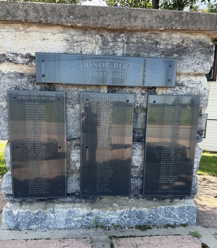
Honor Roll Marker: World War I AND World War II, part 2
301 ► New York, Albany County, Cohoes — Honor Roll — First Ward — 1914-1975 —
1914 Honor Roll 1975 First Ward World War | 1914-1918 World War II 1941-1945 Ashworth John B. · Ashworth, Leslie B. · ★ Baillargeon, Vela P. · Barna, George · Barna John · Bellrose, Bernard · Bellrose, Louis G. · Bernard, . . . — — Map (db m282819) WM
302 ► New York, Albany County, Cohoes — Horace B. Silliman — His Life and Legacy —
Horace Brinsmade Silliman was born in 1825. He was educated in Albany Academy, graduated from Union College in 1846 (a member of Phi Beta Kappa) and later received honorary degrees from Union and Hamilton Colleges. Silliman first became a . . . — — Map (db m41361) HM
303 ► New York, Albany County, Cohoes — How a Lock Works —
Cohoes had the greatest concentration of locks along the Erie Canal. Canal locks are like elevators that move barges from one level of water to another. Water flows into and out of the lock chamber by gravity. The high level of water flows into . . . — — Map (db m280771) HM
304 ► New York, Albany County, Cohoes — In All Seasons / Ebbs and Flows For Shipyard Workers — Peebles Island State Park —
In All Seasons Shipbuilding and repair is mostly outdoor work— hot in the summer and cold in the winter. The office building at the north end of the site had heated space for draftsmen, bookkeepers, and managers but most of the other buildings . . . — — Map (db m275042) HM
305 ► New York, Albany County, Cohoes — James “Buttermilk” Lansing —
Home of James "Buttermilk” Lansing Built by Douw Fonda before 1767. One of founders of Boght Settlement, Cohoes, N.Y. — — Map (db m147936) HM
306 ► New York, Albany County, Cohoes — Juncta —
Junction of the Original Erie and Champlain Canals First Settlement and Name of Cohoes. Site of the First Post Office. — — Map (db m6161) HM
307 ► New York, Albany County, Cohoes — Knickerbacker Toll Bridge —
This Toll Bridge Opened to the Public. May 18th 1880. Originated and Owned by Thomas A. Knickerbacker. Was Destroyed By Fire March 7, 1920. — — Map (db m115502) HM
308 ► New York, Albany County, Cohoes — Misty 17 —
"Misty" was the call sign used by the F-110F Fast Forward Air Controllers (Fast Fac's) during the Vietnam War. There were 155 pilots officially assigned to fly missions over North Vietnam from June 15, 1967 to May 19, 1970. 21 other attached pilots . . . — — Map (db m40826) HM
Paid Advertisement
309 ► New York, Albany County, Cohoes — Navigating Around Cohoes Falls —
To many early travelers, Cohoes Falls was as much an obstacle as a scenic wonder. Over the span of a hundred years, three different channels and sets of locks were constructed to lift and lower boats 163 feet past the falls and rapids at Cohoes. . . . — — Map (db m280880) HM
310 ► New York, Albany County, Cohoes — New York Power Authority —
The present day hydroelectric power plant located at this site is owned and operated by the New York Power Authority. It was constructed in 1908 when the Mohawk River was dammed, the Waterford Flight of Locks was constructed, and the Erie Canal . . . — — Map (db m138991) HM
311 ► New York, Albany County, Cohoes — Old Military Crossing — Loudon’s Ford —
British and Continental Army ford. Protected August September 1777 by Generals Enoch Poor and Benedict Arnold. — — Map (db m138976) HM
312 ► New York, Albany County, Cohoes — Old Military Crossing —
Prior to the construction of the New York State Barge Canal and dam at Crescent, the Mohawk River was shallow and fordable most of the year. For centuries, Native Americans had crossed at this place. In 1755, during the French and Indian War, a . . . — — Map (db m268021) HM
313 ► New York, Albany County, Cohoes — Power Canal Park —
In 1834, the Cohoes Hydraulic Company built a dam above the Cohoes Falls, harnessing the abundant flow of the Mohawk River for industrial use. The Cohoes Company gradually developed a series of canals that provided low-cost waterpower to local . . . — — Map (db m280620) HM
314 ► New York, Albany County, Cohoes — Reformed Church of the Boght —
Site of Reformed Church of the Boght, one of first churches north of Albany, built about 1783. — — Map (db m255761) HM
315 ► New York, Albany County, Cohoes — Rise of the Harmony Company — Cohoes Heritage Trail —
The Harmony Mills Company was a leader in America's industrial revolution. It was incorporated in 1836 by Peter Harmony and 21 others. In 1837, the Harmony Manufacturing Company began to construct a large cotton factory, a four-story brick . . . — — Map (db m280649) HM
316 ► New York, Albany County, Cohoes — Sightseeing / Cataract House, Cohoes Falls, N.Y. —
Sightseeing Dutch visitors left the first written accounts of the Great Falls of the Mohawk River at Cohoes during the 1640s. Generations of sightseers, poets, and artists followed to look at the falls, hear their roar, and feel the spray. . . . — — Map (db m11612) HM
317 ► New York, Albany County, Cohoes — The Cohoes Mastodont —
The Cohoes Mastodont was discovered during the excavation for Harmony Mill #3 in 1866. The mill is sometimes referred to as the "Mastodon Mill" for this reason. When all the bones were recovered, they were kept at the Harmony Mills Office on . . . — — Map (db m41622) HM
Paid Advertisement
318 ► New York, Albany County, Cohoes — The Erie Canal — Power Canal Park | Cohoes NY —
The Erie Canal flowed through Cohoes along two distinct paths during the 19th century. The first phase, 1825-1841, is commonly referred to as "Clinton's Ditch" after New York Governor DeWitt Clinton, who was the foremost advocate for construction . . . — — Map (db m42224) HM
319 ► New York, Albany County, Cohoes — The Harmony Mills —
The Harmony Mills were the primary catalyst for transforming Cohoes into a prominent 19th century manufacturing center. With extremely successful local management by Robert and David John Johnston, Thomas Garner and Company expanded a single cotton . . . — — Map (db m280631) HM
320 ► New York, Albany County, Cohoes — The Harmony Mills Historic District —
By the 1870s, the Harmony Mills had national significance as one of the largest and most technologically advanced cotton factories in the United States. Prior to 1870, no single mill operation in America equaled the Harmony Mills in scale or . . . — — Map (db m280611) HM
321 ► New York, Albany County, Cohoes — The Matton Shipyard —
The Matton Shipyard John E. Matton built his shipyard here on Van Schaick Island in 1916, shortly after the new Barge Canal opened. Besides building barges and tugboats, the shipyard serviced and repaired the boats that travelled both the . . . — — Map (db m48282) HM
322 ► New York, Albany County, Cohoes — Van Schaick Burial Plot —
First Settlers of Cohoes And Owners of Half Moon Patent Buried Here — — Map (db m7249) HM
323 ► New York, Albany County, Cohoes — Van Schaick Island —
Military encampment   1777 Here, in the days leading up to the Battles of Saratoga, 5,000 – 8,000 Continental soldiers were garrisoned. — — Map (db m37454) HM
324 ► New York, Albany County, Cohoes — Van Schaick Mansion —
1735 - 1927 Van Schaick Mansion Home Of John G. Van Schaick and his Wife Anna Patriot Americans Built by Anthony Van Schaick Son of Goosen Gerritsen original patentee Headquarters August 18-September 8-1777 Northern . . . — — Map (db m7250) HM
325 ► New York, Albany County, Cohoes — Van Schaick Mansion —
In 1777, this mansion was the headquarters for the Northern Department of the Continental Army, and the site where the victorious Saratoga Campaign was planned. Revolutionary War Heritage Trail — — Map (db m37455) HM
326 ► New York, Albany County, Cohoes — Van Schaick Mansion — Revolutionary War Heritage Trail —
The plans for the Battle of Saratoga were drawn up in this house in the summer of 1777, when the American Army was headquartered here. That April General Philip Schuyler and 5,000 troops retreated from Fort Edward in advance of Burgoyne’s superior . . . — — Map (db m37457) HM
Paid Advertisement
327 ► New York, Albany County, Cohoes — Water for Power —
The power of falling water built Cohoes, where mills and factories on power canals used waterpower to manufacture textiles and metal goods. Today the energy of Cohoes Falls is carried through wires to homes and businesses throughout eastern New . . . — — Map (db m280758) HM
328 ► New York, Albany County, Colonie — Boght Church —
Site of the Reformed Dutch Church of the Boght 1st Church North of Albany Organized by the Classis Of Albany, Feb. 22, 1784 — — Map (db m24730) HM
329 ► New York, Albany County, Colonie — Dalessondro Boulevard —
In December of 1944, near Kalterherberg, Germany Technical Sergeant Peter J. Dalessondro of the 9th Infantry Division, at great personal risk, intrepidly fought against overwhelming enemy attack to save his company from defeat. His singlehanded . . . — — Map (db m21881) HM
330 ► New York, Albany County, Colonie — Fox Preserve —
This 70-acre property was donated to the Mohawk Hudson Land Conservancy by Dr. Patricia Fox in 2015. Dr. Fox owned the property for over 30 years, and it is one of the last remaining areas of open space in this area of the Town of Colonie. Through . . . — — Map (db m147937) HM
331 ► New York, Albany County, Colonie — NY-19 — Gen. Henry Knox Trail —
Through this Place Passed Gen. Henry Knox In the Winter of 1775 - 1776 To Deliver To Gen. George Washington At Cambridge The Train of Artillery From Fort Ticonderoga Used to Force the British Army to Evacuate Boston . . . — — Map (db m23749) HM
332 ► New York, Albany County, Colonie — Loudoun Ferry Road —
1755 Constructed as Military Road from Albany to Lake George by Provincial Troops from New York, New England and New Jersey under command of Major General William Johnson ——— Named in honor of Major General . . . — — Map (db m24514) HM
333 ► New York, Albany County, Colonie — Maplewood Historic Park —
Site of Erie Canal lock & former Weighlock Bldg.1850-1915 located near "The Juncta" of old Erie and Champlain Canals — — Map (db m40996) HM
334 ► New York, Albany County, Colonie — Schuyler Flatts —
Farm of Arendt Van Curler 1643-1667. Pieter Schuyler & Margarita Schuyler after 1672. Fortified 1747, and Military Encampment 1750's — — Map (db m184813) HM
335 ► New York, Albany County, Colonie — Shaker Cemetery —
First burials occurred on this historic site in 1787- Mother Ann Lee and early leaders reburied here later — — Map (db m41150) HM
Paid Advertisement
336 ► New York, Albany County, Colonie — Shaker Church Family Barn —
Built in 1916 on the site of the original barn which had been destroyed by fire — — Map (db m40593) HM
337 ► New York, Albany County, Colonie — The Boght —
The Boght Settled On and After 1704 By The Vischer Weaver Witbeck Lansing Powell Runkle Dunsbach Lieverse Staats Roff Godfrey Van O Linde Groesbeck Van Vranken Fero Van De Mark Van Denburgh Johnson Pollock Storms Fonda and . . . — — Map (db m24731) HM
338 ► New York, Albany County, Colonie — The Erie Canal —
For nearly a century, canal boats were pulled by mules and horse over this portion of New York State's famed Erie Canal. One of the slowest and most crowded parts of the waterway started to the north of the Flatts at Maplewood. Here Began the . . . — — Map (db m14742) HM
339 ► New York, Albany County, Colonie — The Weighlock Building — 1850-1915 —
This Greek-revival building was one of several weigh stations along the Canal used to levy the tolls for barges carrying merchandise and farm goods. Until 1850 freight cargoes were measured by the displacement theory, but this hydraulic type . . . — — Map (db m40999) HM
340 ► New York, Albany County, Colonie, Newtonville — Newtonville —
Site of the First Baptist Church 1852 Rev. Wm. Arthur, Preacher Father of 21st President Chester Alan Arthur — — Map (db m261896) HM
341 ► New York, Albany County, Cooksberg, Preston Hollow — Potter Palmer — 1826 —
Birthplace of Potter Palmer; merchant, entrepreneur, and builder of the Palmer House Hotel in Chicago. — — Map (db m249469) HM
342 ► New York, Albany County, Delmar — Delmar —
Earlier Adamsville And Adams Station Nathaniel Adams Located Here In 1836 and Built A Hotel in 1838 — — Map (db m97281) HM
343 ► New York, Albany County, Delmar — Delmar Post Office —
Delmar Post Office has been placed on the National Register of Historic Places by the United States Department of the Interior 1939 — — Map (db m305132) HM
344 ► New York, Albany County, Delmar — Five Rivers Historic Site —
2500 BC   Late Archaic Period Indian Encampment 1791   The Patroon granted 230 acres to the Radley family 1933   New York State purchased the Radley and Ackerman farms 1933-36   Base camp for Civilian Conservation Corp. S72 - Co. 270 that . . . — — Map (db m263982) HM
Paid Advertisement
345 ► New York, Albany County, Delmar — In This Hamagrael Area —
Is buried a soldier of the American Revolution Lt. John Leonard, 5th Regiment Albany County Militia — — Map (db m308202) HM
346 ► New York, Albany County, Delmar — Leonard Farm Site —
Established ca. 1786 by Lt. John Leonard 3rd and 5th Regiments Albany County Militia American Revolutionary War — — Map (db m244765) HM
347 ► New York, Albany County, Delmar — The Van Deusen House — An 18th Century Bethlehem Farmstead —
This vernacular stone house was constructed c. 1793 by family members of Johannes “John” Van Deusen, the proprietor of these former farmlands. The Town of Bethlehem was established that very same year, during the first decade of America’s . . . — — Map (db m308055) HM
348 ► New York, Albany County, Delmar — Town of Bethlehem Veterans Memorial —
Erected In Honor Of The Men And Women Of The Town Of Bethlehem Who Served In The Armed Forces And In Memory Of Those Who Made The Supreme Sacrifice — — Map (db m142348) WM
349 ► New York, Albany County, Delmar — Union Dutch Reformed Church —
Founded and Erected 1825. "For The Glory of God" quoted from 1824 land deed. Horse sheds built 1840. Fellowship hall added 1906. — — Map (db m97276) HM
350 ► New York, Albany County, Delmar — Van Deusen House —
Built by John Van Deusen Albany carpenter & firemaster ca. 1793 on 200-acre farmstead Later farmed by Bradt, Ostrander, Leonard families until 1980s — — Map (db m308046) HM
351 ► New York, Albany County, Delmar — Smoke House Hill Farm —
. . . — — Map (db m263981) HM
352 ► New York, Albany County, Delmar — The Five Rivers Mini Forest —
Welcome to The Five Rivers Mini Forest "Let us plant trees together-from under our feet, and into the world." —Dr. Akira Miyawaki This 2,000-square-foot forest was planted in June 2025 by the Department of Environmental . . . — — Map (db m309027) HM
353 ► New York, Albany County, Dormansville — Andrew Hannay —
Near here Andrew Hannay raised a company of volunteers October 1777 to oppose invasion of Burgoyne who surrendered before their arrival — — Map (db m135130) HM
Paid Advertisement
354 ► New York, Albany County, Dormansville — Dormansville —
Named in honor of Daniel Dorman, an inn and store keeper, and first postmaster in 1832 — — Map (db m135109) HM
355 ► New York, Albany County, Dormansville — Dormansville War Memorial —
Dedicated to the men and women of Dormansville NY who served in the wars of our country — — Map (db m135134) WM
356 ► New York, Albany County, Dormansville — Reformed Church —
Original site of the Dutch Reformed Church organized 1793. Present location Village of Westerlo. — — Map (db m136003) HM
357 ► New York, Albany County, East Berne — Anti-Rent Riots —
More Leased Land in Berne than any other Town in Albany County Led to Serious Outbreaks After 1840 — — Map (db m50489) HM
358 ► New York, Albany County, East Berne — Lutheran Church —
Organized 1790. First pastor Rev. August Friederich Meier. Frame building used until brick church constructed 1835 — — Map (db m132604) HM
359 ► New York, Albany County, East Berne — Mill Site —
Mill built here about 1765 by John and Christopher Warner — — Map (db m132602) HM
360 ► New York, Albany County, Elsmere — Connecting People With Communities — The Elsmere Train Station —
The Elsmere Train Station The hamlet of Elsmere represents the influence which railroads had on the growth of suburban communities. In 1863, when the first A&S Railroad train left Adams Station for Albany, the area now known as Elsmere . . . — — Map (db m185915) HM
361 ► New York, Albany County, Elsmere — Helderberg-Hudson Rail Trail — A History of the Albany County Helderberg-Hudson Rail Trail —
This trail is a 9-mile pathway which follows the old Albany and Susquehanna Railroad between Albany and Voorheesville. This pathway connects visitors with landscapes and communities, including the dramatic Normanskill Gorge in the City of . . . — — Map (db m185901) HM
362 ► New York, Albany County, Feura Bush — Bennett Hill House —
House built 1821 by Wm. C. Hewitt for Wm. Chapman. 1834 Rushmore Bennett started an apple and sheep farm. Summer boarding house 1890's-1920's. — — Map (db m276308) HM
Paid Advertisement
363 ► New York, Albany County, Feura Bush — Early Business District —
Railroad depot c. 1870 Hallenbeck's Store c. 1910 Hathaway's Tavern c. 1919 Rothaupt's Blacksmith Shop — — Map (db m144754) HM
364 ► New York, Albany County, Feura Bush — Jerusalem Reformed Church —
Established 1791. First located on Route 308. Rev. Harmanus Van Huysen was pastor 1793-1825. Current edifice built 1826. — — Map (db m130527) HM
365 ► New York, Albany County, Feura Bush — Memorial —
This memorial is dedicated in honor to all those who served our great country. — — Map (db m130529) WM
366 ► New York, Albany County, Feura Bush — 500 — Onesquethaw Valley Historic District —
Onesquethaw Valley Historic District has been placed on the National Register of Historic Places in 1974 by the United States Department of the Interior — — Map (db m263980) HM
367 ► New York, Albany County, Feura Bush — Oriskatach —
Gerrit van Zandt house built circa 1755. Quartered as many as one hundred soldiers during French and Indian Wars — — Map (db m263963) HM
368 ► New York, Albany County, Feura Bush — 146 — Patriot Burials — Jerusalem Cemetery —
At least ten Albany County & New York militia Revolutionary War veterans interred here circa 1787-1847. — — Map (db m284697) HM
369 ► New York, Albany County, Feura Bush — 274 — Patriot Burials — Onesquethaw Union Cemetary —
Revolutionary War Veterans D. Mead, J. Mead, W. Rowe and D. Van Dyke buried here ca. 1831-1859. — — Map (db m314833) HM
370 ► New York, Albany County, Feura Bush — Slingerland House 1762 —
Built by Tunis Cornelise Slingerland, Dutch emigrant 1650, on land purchased from Indians — — Map (db m130530) HM
371 ► New York, Albany County, Feura Bush — Slingerland-Lagrange Farm —
Family owned 12 Generations. Stone house built c.1750's. Home of Revolutionary War soldier Albert Slingerland. — — Map (db m306928) HM
Paid Advertisement
372 ► New York, Albany County, Feura Bush — The Wemp Barn —
Mohawk Valley Dutch barn built in the early 1700's by Jan Wemp, Indian trader yeoman and master builder — — Map (db m263962) HM
373 ► New York, Albany County, Feura Bush, New Scotland — Moakville —
Named after early settlers, renamed Jerusalem after the Jerusalem reformed church, later became Feura Bush when post office was added. — — Map (db m303907) HM
374 ► New York, Albany County, Feura Bush, Tarrytown — DeLong-Vanderbilt Home - June 5,1807 —
Lake Creek Farm, later Niskithaw Acres, built by David DeLong, father of Abiah Vanderbilt. farmed since it was settled. — — Map (db m276298) HM
375 ► New York, Albany County, Feura Bush, Tarrytown — Onesquethaw Reformed Church —
The stone, builders rejected, has become the chief cornerstone. Psalm 118:22 Church built 1825 of stone rejected for the Erie Canal. — — Map (db m276304) HM
376 ► New York, Albany County, Feura Bush, Tarrytown — Van Dyke House —
Built in 1788, by David Van Dyke a Revolutionary War veteran. The property was once part of the Rensselaerswyck Manor. — — Map (db m276296) HM
377 ► New York, Albany County, Fullers — Abraham Wemple —
Col. Schenectady militia during American Revolution owned farm here 1765 to death in 1799. Buried on high knoll above reservoir. — — Map (db m144957) HM
378 ► New York, Albany County, Glenmont — This is the Capital District — Historic New York —
          The Capital District has long been important as a trading post, military objective and governmental center. Located near the juncture of the Hudson and Mohawk rivers, Albany has been the “crossroads” of the northeast since . . . — — Map (db m56854) HM
379 ► New York, Albany County, Glenmont — Van Wie Point —
Hendrick Gerritse van Wie Dutch colonist in Fort Orange 1664, built house here in 1679 — — Map (db m246508) HM
380 ► New York, Albany County, Glenmont — Van Wie’s Dock —
Site of the dock owned by Peter G. & Henry van Wie and leased Feb. 23, 1835 to Hudson River Steamboat Co. for Albany terminal — — Map (db m246507) HM
Paid Advertisement
381 ► New York, Albany County, Glenmont — 163 — Votes for Women — Road to the 19th Amendment — National Votes for Women Trail —
Former estate of Judge Elisha Powell Hurlbut. Wrote "Rights of Woman" essay in 1841. Served on state suffrage committee 1880-1882. — — Map (db m223915) HM
382 ► New York, Albany County, Green Island — Unique Urban Village/ Resilient Factory Town/ Ford —
A Unique Urban Village We're not a big city, but we're not a small town either. And while the northern half of our island is home to Honeywell, Lydall, Sealy Mattress, Silhouette Eyewear and numerous other industries, factories no longer . . . — — Map (db m256010) HM
383 ► New York, Albany County, Green Island — Water Fire Iron / .7 Sq. Mi. / Age of Rail —
.7 Sq. Mi. You are here. (actually, just a tiny bit north of here). Welcome to Green Island! This map shows the State Dam, which was destroyed by the 1913 flood. The Federal Dam, pictured above, was built in 1916. The entire . . . — — Map (db m256004) HM
384 ► New York, Albany County, Green Island — Welcome to Green Island — A Unique Urban Village —
The Entire History of Industrial America comes to a concentrated point here in the 0.7-square mile town and village of Green Island. The age of iron was literally forged here. Starbuck Brothers, Morris and Manning, Green Island Malleable . . . — — Map (db m255785) HM
385 ► New York, Albany County, Guilderland — Battle of Normanskill —
Fought north of the creek Schenectady Militia with 40 Rhode Island troops dispersed large group of Tories on August 11, 1777 — — Map (db m49379) HM
386 ► New York, Albany County, Guilderland — Captain Jacob Van Aernam — 1732 - 1813 —
Revolutionary hero buried here. Courageous always he fought for his beloved Country's independence. — — Map (db m44031) HM
387 ► New York, Albany County, Guilderland — Case Homestead —
Built as tavern by Russell Case at the opening of Great Western Turnpike, 1799 — — Map (db m220600) HM
388 ► New York, Albany County, Guilderland — Dr F. Crounse —
Built this house, 1833 First physician at West Guilderland (Altamont) Practiced here sixty years — — Map (db m49844) HM
389 ► New York, Albany County, Guilderland — Farm of Evert Bancker —
Third Mayor of Albany, 1695 Indian Commissioner, 1696 Master Chancery, 1705 Died Here, 1734 — — Map (db m50126) HM
390 ► New York, Albany County, Guilderland — First Lutheran Church —
On this spot stood the First Lutheran Church in Town of Guilderland 1787. Rev. Heinrich Moeller first regular pastor — — Map (db m48961) HM
391 ► New York, Albany County, Guilderland — First Meeting —
of Town of Guilderland held April 5, 1803 in this house at that time a tavern conducted by Hendrick Apple — — Map (db m49845) HM
392 ► New York, Albany County, Guilderland — First Reformed Dutch Church —
100 ft. W Site of the First Reformed Dutch Church in Guilderland. Built before 1767. First pastor Rev. Harmanus Van Huysen — — Map (db m136065) HM
393 ► New York, Albany County, Guilderland — Frederick Crounse —
Farm of Frederick Crounse Officer 3D Albany Co. Militia in Revolution. Carried food to Army Battle of Saratoga. Buried Here — — Map (db m48377) HM
394 ► New York, Albany County, Guilderland — French's Hollow —
Site of a Sawmill; Clothe Wks of Peter K. Broeck 1795; Factory of Abel French and Tavern of Jacob Aker 1800 — — Map (db m65413) HM
395 ► New York, Albany County, Guilderland — 1011 — Fullers —
Hamlet est. here by ca. 1875 along Great Western Turnpike. included toll gate, school, stores, post office, railroad station, hay presses & homes. — — Map (db m254502) HM
396 ► New York, Albany County, Guilderland — George Wagner —
Home of George Wagner Lieutenant in the American Revolution — — Map (db m63346) HM
397 ► New York, Albany County, Guilderland — Glass Works —
Begun 1785 by Leonard De Neuville. Known as Albany Glass House, later Hamilton Glass Wks. Made bottles & window glass. Closed 1815 — — Map (db m50620) HM
398 ► New York, Albany County, Guilderland — Guilderland Town Hall —
Town Hall Town of Guilderland Est. April 4, 1803 First Officers; Supervisor Nicholas V. Mynderse, Clerk Peter G. Veeder Town of Guilderland 1985 — — Map (db m103165) HM
399 ► New York, Albany County, Guilderland — Hamilton Glass House —
. . . — — Map (db m45518) HM
400 ► New York, Albany County, Guilderland — Henry Rowe Schoolcraft —
Home of Henry Rowe Schoolcraft b.1793 - d. 1864. Glass maker, explorer, author, poet, authority on American Indians. — — Map (db m77593) HM

17812 entries matched your criteria. Entries 301 through 400 are listed above. ⊲ Previous 100 — Next 100 ⊳
 
 
CeraNet Cloud Computing sponsors the Historical Marker Database.
This website earns income from purchases you make after using our links to Amazon.com. We appreciate your support.
Paid Advertisement
Nov. 11, 2026
