44 entries match your criteria.
Historical Markers and War Memorials in Belize
By J. Makali Bruton, February 26, 2015
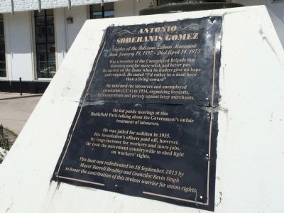
The previous Antonio Soberanis Gomez Marker
| 1 ► Belize, , Belize City — Antonio Soberanis Gomez — Father of the Belizean Labour Movement — |
| 2 ► Belize, , Belize City — Belize National World War I Cenotaph — |
| Near Marine Parade Boulevard just north of South Park Street, on the left when traveling north. | |||
| 3 ► Belize, , Belize City — British Honduras Territorial Force Memorial — |
| Near South Park Street just west of Marine Parade Boulevard, on the right when traveling west. | |||
| 4 ► Belize, , Belize City — Death of William Hart Bennett — |
| On Regent Street, on the right when traveling north. | |||
| 5 ► Belize, , Belize City — Mule Park — |
| On Albert Street at Regent Street, on the left when traveling south on Albert Street. | |||
| 6 ► Belize, , Belize City — Saint John's Anglican Cathedral — |
| On Albert Street just south of Berkley Street, on the left when traveling south. | |||
| 7 ► Belize, , Burrell Boom — Burrell Boom — |
| 8 ► Belize, , La Democracia — Ceiba Tree — |
| Near Western Highway, 0.4 kilometers north of Coastal Highway. | |||
| 9 ► Belize, , Ladyville — The Belize Defence Force Fallen — |
| On Old Airport Road, on the right when traveling west. | |||
| 10 ► Belize, , Rock Stone Pond — The Tomb of the Jade Head at Altun Ha — |
| Near Old Northern Highway. | |||
| 11 ► Belize, Cayo, Belmopan — Agripino Cawich Bridge — |
| 12 ► Belize, Cayo, Belmopan — Belize's 10th Anniversary of Independence — |
| Near Bliss Parade just east of Constitution Drive, on the left when traveling east. | |||
| 13 ► Belize, Cayo, Belmopan — Founding of Belmopan — |
| On Western Highway (at milepost 49),, on the left when traveling east. | |||
| 14 ► Belize, Cayo, Belmopan — Harriot W. Topsey — |
| On Constitution Drive at North Ring Road on Constitution Drive. | |||
| 15 ► Belize, Cayo, Belmopan — Olmec Colossal Head — |
| On Constitution Drive at North Ring Road, in the median on Constitution Drive. | |||
| 16 ► Belize, Cayo, Belmopan — Rt. Hon. George C. Price — |
| On Price Center Road, on the right when traveling east. | |||
| 17 ► Belize, Cayo, Belmopan — The Flag of Belize — |
| Near Bliss Parade just east of Constitution Drive, on the left when traveling east. | |||
| 18 ► Belize, Cayo, Red Creek, Esperanza — Esperanza — |
| On Western Highway just east of Eve Street, on the left when traveling east. | |||
| 19 ► Belize, Cayo, San Ignacio — Altar 21 at Caracol — (A Group Ballcourt; Structures A11 & A12) — |
| 20 ► Belize, Cayo, San Ignacio — The Centennial of El Cayo — The Naming of San Ignacio — |
| On Joseph Andrews Drive just north of Savannah Street, on the left when traveling north. | |||
| 21 ► Belize, Corozal, Corozal Town — 6 of 7 — Corozal Town Central Park — Corozal Town Historical Walk — |
| On 1st Street South just south of 5th Avenue, on the left when traveling south. | |||
| 22 ► Belize, Corozal, Corozal Town — 5 of 7 — Corozal Town Hall — Corozal Town Historical Walk — |
| On 1st Street South just south of 5th Avenue, on the right when traveling south. | |||
| 23 ► Belize, Corozal, Corozal Town — Felipe Santiago Ricalde — |
| On 1st Street North just west of 4th Avenue, on the left when traveling west. | |||
| 24 ► Belize, Corozal, Corozal Town — 7 of 7 — Fort Barlee — Corozal Town Historical Walk — |
| On 5th Avenue at 1st Street North, on the left when traveling east on 5th Avenue. | |||
| 25 ► Belize, Corozal, Corozal Town — 2 of 7 — Her Majesty's Prison — |
| On 2nd Street South just south of 4th Avenue, on the right when traveling south. | |||
| 26 ► Belize, Corozal, Corozal Town — 1 of 7 — House of Culture/Public Market — Corozal Town Historical Walk — |
| On 1st Avenue at 2nd Street South, on the left when traveling west on 1st Avenue. | |||
| 27 ► Belize, Corozal, Corozal Town — 4 of 7 — Parish Office/Priest’s Residence/Xavier College — Corozal Town Historical Walk — |
| On 1st Street South just south of 4th Avenue, on the left when traveling south. | |||
| 28 ► Belize, Corozal, Corozal Town — 3 of 7 — Schofield Residence — Corozal Town Historical Walk — |
| On 1st Avenue at 1st Street South, on the right when traveling east on 1st Avenue. | |||
| 29 ► Belize, Orange Walk, Indian Church — Royal Complex at Lamanai — |
| 30 ► Belize, Orange Walk, Indian Church — Stela 9 at Lamanai — |
| 31 ► Belize, Orange Walk, Indian Church — The High Temple at Lamanai — |
| 32 ► Belize, Stann Creek, Dangriga — Thomas Vincent Ramos — |
| On Front Street just north of Myers Street, on the left when traveling north. | |||
| 33 ► Belize, Stann Creek, Hopkins — The Serpon Sugar Mill — |
| Near South Hopkins Road just east of Southern Highway, on the right when traveling east. | |||
| 34 ► Belize, Toledo, Harvest Caye — Antillean Manatee — |
| 35 ► Belize, Toledo, Harvest Caye — Black Howler Monkey — Alouatta Pigra — |
| 36 ► Belize, Toledo, Harvest Caye — Dugout Canoe — |
| 37 ► Belize, Toledo, Harvest Caye — Hawksbill Turtle — Eretmochelys imbricateta — |
| 38 ► Belize, Toledo, Indian Creek — Ball Court — Structures 18 & 19 — |
| On Nim Li Punit Mayan Ruins Road, 0.4 kilometers north of Southern Highway. | |||
| 39 ► Belize, Toledo, Indian Creek — E-Group — |
| On Nim Li Punit Mayan Ruins Road, 0.4 kilometers north of Southern Highway. | |||
| 40 ► Belize, Toledo, Indian Creek — The Royal Residence — Structure 7 — |
| On Nim Li Punit Mayan Ruins Road, 0.4 kilometers north of Southern Highway. | |||
| 41 ► Belize, Toledo, Indian Creek — Tomb #1 — Structure 5 — |
| On Nim Li Punit Mayan Ruins Road, 0.4 kilometers north of Southern Highway. | |||
| 42 ► Belize, Toledo, Punta Gorda — Lila ‘Leela' Genus Vernon — |
| On Main Middle Street at Queen Street, on the right when traveling west on Main Middle Street. | |||
| 43 ► Belize, Toledo, Punta Gorda — The Rt. Hon. George Cadle Price — |
| On George Price Street at Main Middle Street, on the left when traveling west on George Price Street. | |||
| 44 ► Belize, Toledo, San Pedro Columbia — Ball Court — |
| Near Southern Highway. | |||