On Briggs Street at Mill Creek Street, on the right when traveling south on Briggs Street.
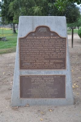
Danish sea captain Cornelius Jensen sailed to San Francisco during the Gold Rush to sell his cargo. In 1854 he settled in Agua Mansa, established a store, and married Mercedes Alvarado, a descendant of a pioneer Californio family. The Jensens . . . — — Map (db m50685) HM
On South San Jacinto Avenue (California Route 79) at East 6th Street, on the right when traveling south on South San Jacinto Avenue.
Three miles west of this site, on July 14, 1937, three Soviet aviators completed a transpolar flight from Moscow in 62 hours, 17 minutes, establishing a new world's nonstop distance record of 6,305 miles. The huge single-engine aircraft, an ANT-25 . . . — — Map (db m50706) HM
On Cottonwood Avenue at South Sanderson Avenue, on the right when traveling east on Cottonwood Avenue.
Near this site on July 14, 1937, three Russian aviators completed a transpolar flight from Moscow in 62 hrs, 17 min establishing a new world's nonstop distance record of 6,305 miles. The huge single-engine aircraft, an ANT-25 military reconnaissance . . . — — Map (db m50681) HM
On Vía Tornado at Via Novillo, on the right when traveling north on Vía Tornado.
[Upper Marker]
Here, before his death
in 1927, Murray Schloss
collected 2500 acres
for a utopian community
E Clampus Vitus
Billy Holcomb Chapter
1973
[Lower Marker]
Re-Dedicated by
The Billy Holcomb . . . — — Map (db m78530) HM
On Crater Road, 0.5 miles west of National Trails Highway, on the right when traveling west.
Amboy Crater, formed of ash and cinders, is 250 feet high and 1500 feet in diameter. The crater is in one of the youngest volcanic fields in the United States. Six distinct periods of eruptions created the resulting nested group of volcanic cinder . . . — — Map (db m78561) HM
In 1860 the U.S. Army established an outpost at Soda Springs to protect government supplies from Indians. Later, miners processed the adjacent lake minerals. In 1906 the Tonopah & Tidewater railroad arrived. From 1944 to 1974 Dr. Curtis H. Springer . . . — — Map (db m78587) HM
Harvey Houses were legendary in the history of Western rail travel. Operated by Fred Harvey in conjunction with this Santa Fe Railway, the network of restaurant-hotels set a new standard in quality meal service. Barstow's Spanish-Moorish "Casa Del . . . — — Map (db m50666) HM
On North 1st Avenue, on the left when traveling west.
Around the time of the Civil War, railroads were being built at a frantic pace. By the early 1870s there were 60,000 miles of track in the U.S., increasing to 250,000 by the 1930s. The war had produced a generation of young men used to living under . . . — — Map (db m114804) HM
Near Greenway Drive, 0.3 miles north of Big Bear Boulevard, on the right when traveling north.
Southern California's largest gold rush followed the discovery of rich placer deposits by William F. Holcomb and Ben Choteau on May 4, 1860. Miners rushed to the valley and established boom towns. Belleville, the largest, rivaled San Bernardino in . . . — — Map (db m50702) HM
On Eucalyptus Avenue near Pipeline Avenue, on the right when traveling west.
Near this site, Isaac Williams in 1841 built a large adobe home, located on the 22,000-acre Rancho Chino which he acquired from his father-in-law Antonio Lugo. The "Battle of Chino" occurred at the adobe on September 26-27, 1846, during which 24 . . . — — Map (db m50665) HM
On Cypress Avenue at Sierra Avenue, on the right when traveling south on Cypress Avenue.
In March 1928, the Federal Government established the first and only experimental station in the United States devoted solely to research on the breeding and raising of rabbits on a five-acre property donated by A. B. Miller of Fontana. The station . . . — — Map (db m50670) HM
On Lanfair Road at Goffs Road, on the right when traveling south on Lanfair Road.
Pah-Ute Creek, which runs year around, attracted many Indian tribes, who used several Indian trails through this area. The first white man to visit Pah-Ute Creek was Fr. Francisco Garces in May of 1776. It was given it's name by Lt. A.W. Whipple . . . — — Map (db m78577) HM
On Old Government Road at Lanfair Road, on the right when traveling east on Old Government Road. Reported missing.
In January of 1893 construction of Isaac C. Blake's Nevada Southern Railway commenced northward from Goffs toward Manvel (later known as Barnwell) for the purpose of hauling ore from the mining districts of southeastern California and southern . . . — — Map (db m78524) HM
On Old Woman Springs Road (California Route 18) at Rabbit Springs Road, on the right when traveling west on Old Woman Springs Road.
Conflicts between Indians and white settlers over the rich lands of the San Bernardino Mountains culminated in The Battle at Chimney Rock on February 16, 1867. Although the Indians defended themselves fiercely, they were forced to retreat into the . . . — — Map (db m63982) HM
On Old Woman Springs Road (California Route 247) west of Stoney Ridge Road, on the right when traveling east.
This area of Lucern Valley became known as Old Woman Springs when a government survey party discovered a number of Indian women camping here in 1856. The original water source, now called Cottonwood Springs, is directly in front of you. In 1907 . . . — — Map (db m78538) HM
On National Trails Highway at Crucero Road, on the right when traveling east on National Trails Highway.
...and they shall beat their swords into plowshares, and their spears into pruning hooks: nation shall not lift up sword against nation, neither shall they learn war any more. Micah 4:3
With the end of World War II and the onset of the Cold . . . — — Map (db m78521) HM
On National Trails Highway at Crucero Road, on the right when traveling east on National Trails Highway.
Seeking a more efficient way to get borax from his mines on the east side of Death Valley to processing facilities near Los Angeles, and hoping to tap the booms at Rhyolite, Tonopah, and Goldfield, Nevada, Francis Marion Smith built the Tonopah and . . . — — Map (db m78526) HM
On Interstate 15, 34 miles north of Barstow, on the right when traveling north.
Long ago, Mohave Indians used a network of pathways to cross the Mojave Desert. In 1826, American trapper Jedediah Smith used their paths and became the first non-Indian to reach the California coast overland from mid-America. The paths were worked . . . — — Map (db m96576) HM
On U.S. 95 at milepost 66,, 10 miles north of Interstate 40, on the right when traveling north.
Camp Ibis was established at this site in the spring of 1942 – one of eleven such camps built in the California – Arizona Desert to harden and train United States Troops for service on the battlefields of World War II.
The 440th AAA . . . — — Map (db m78585) HM
Camp Cady was located on the Mojave Road which connected Los Angeles to Albuquerque. Non-Indian travel on this and the nearby Salt Lake Road was beset by Paiutes, Mohaves, and Chemehuevis defending their homeland. To protect both roads, Camp Cady . . . — — Map (db m50718) HM
On Hart Mine Road, 0.4 miles east of Walking Box Ranch Road.
Gold was discovered in the nearby Castle Mountains in December 1907 by Jim Hart and the Hitt brothers, Bert and Clark. The town of Hart quickly sprang up. Its five hotels and eight saloons served a population of about 400. The relatively quiet town . . . — — Map (db m150924) HM
On Desert Center - Rice Road (California Route 62 at milepost 90.7), on the left when traveling east.
Iron Mountain divisional camp was established at this site in the spring of 1942. One of eleven such camps built in the California-Arizona desert to harden and train United States troops for service on the battlefields of World War II. The first . . . — — Map (db m77424) HM
On Aqueduct Road (Route 62 at milepost 112.4), on the right when traveling east.
Camp Rice was established at this site in the spring of 1942. It was one of twelve such camps built in the southwestern deserts to harden and train United States troops for service on the battlefields of World War II. The Desert Training Center was . . . — — Map (db m209934) HM
On Kentucky Street at Dunlap Boulevard, on the right when traveling east on Kentucky Street.
Yucaipa Valley suported a large population of Serrano Indians. The fertile valley was watered by springs and creeks. The Indians called this area "Yucaipat" which meant "wet lands." These Native Americans lived at this village site most of the year, . . . — — Map (db m50684) HM
Jack Longstreet's life before 1880 is unknown. In 1880 Longstreet staked mining claims in Northern Arizona, claimed a Native American Wife, and two years later opened a saloon and drug store in Moapa, Nevada. By 1888, Longstreet was in Oasis Valley, . . . — — Map (db m107098) HM
On Cahuilla Road (State Road 371) at Contreras Road on Cahuilla Road.
Until the 1880s, James Hamilton was among the very first homesteaders in the Cahuilla Plains or Hamilton Plains, now Anza, and was a highly respected pioneer who overcame many obstacles in his life, including prejudice. The Hamilton School District . . . — — Map (db m50709) HM
On California Route 177 at milepost 17 at Coxcomb Monument Road, on the left when traveling north on State Route 177. Reported missing.
Camp Coxcomb was established at this site in the Spring of 1942. It was one of fifteen such camps built in the southwestern deserts to harden and train United States troops for service on the battlefields of World War II. The Desert Training Center . . . — — Map (db m78513) HM
On Cottonwood Springs Road at unknown dirt road, on the right when traveling north on Cottonwood Springs Road.
Camp Young, named after Lt. Gen. S.B.M. Young, the 1st Army Chief of Staff, was established at this site in the Spring of 1942. It was one of twelve such camps built in the southwestern deserts to harden and train United States Troops for service to . . . — — Map (db m78581) HM
On Interstate 40, 6 miles east of the Essex Road Interchange, on the right when traveling east.
Camp Clipper was established at a site that reached
From Essex Road to this location in the spring of
1942. It was one of twelve such camps built in the
Southwestern Desert to harden and train United
States troops for service on the . . . — — Map (db m72258) HM
On California Route 62 at milepost 90.5, on the right when traveling east.
Camp Granite was established at this site in the spring of 1942. It was one of fifteen such camps built in the southwestern deserts to harden and train United States troops for service on the battlefields of World War II. The Desert Training Center . . . — — Map (db m83038) HM
On Ghost Town Road, 4 miles north of Interstate 15.
Calico’s most distinguished and long time resident was Lucy Bell Lane (1874-1967). Known at one time as the “Queen of Calico”, Lucy lived at Calico for nearly 67 years. Of her many gifts, she is most remembered for her warm hospitality . . . — — Map (db m78579) HM
Near Veterans Memorial Highway (U.S. 95 at milepost 9) near Piute Valley Drive, on the right when traveling south.
Originally known as Stage Field, this was an outlying airfield of Camp Ibis, one of the eleven camps established within the Desert Training Center, California-Arizonan Maneuver Area during World War II. Developed by General George S. Patton, Jr., . . . — — Map (db m78522) HM
On Death Valley Road (California Route 127 at milepost 29.8) at Saratoga Springs Road, on the left when traveling north on Death Valley Road.
Some 100 wagons found themselves in Salt Lake City too late to cross the Sierra Nevada. They banded together under the name of Sand Walking Co. and started for the gold fields in California over the old Spanish Trail. After being in Death Valley . . . — — Map (db m159400) HM
On North K Street, on the left when traveling north.
This bridge marks the site where the National Old Trails Highway later Highway 66 crossed the Colorado River. It links the Mojave Indian lands visited by Father Garces in 1776. Near this location the American Explorer, Jedediah Smith and his band of . . . — — Map (db m50647) HM
On Vineyard Avenue at Foothill Boulevard, on the right when traveling north on Vineyard Avenue.
In 1839 Governor Juan Alvarado granted the 13,000-acre tract called Cucamonga to Tiburcio Tapia, an ex-soldier who was a prominent merchant and alcalde in Los Angeles. A half-mile west of this marker Tapia, employing Indian laborers, immediately . . . — — Map (db m149478) HM
On Pine Cove Road at Chickadee Lane, on the right when traveling north on Pine Cove Road.
From this location instruments reflected light in 1926 to Mount Wilson, 82 miles northwest. The work was one of a series of experiments conducted by Nobel Prize-winning scientist Dr. Albert A. Michelson to refine the value of the speed of light. . . . — — Map (db m129941) HM
On County Highway 91 at Old Pioneer Road on County Highway 91.
The Old Spanish Trail, the main trade route between Santa Fe and Los Angeles, passed this way beginning in 1829. At the end of the Mexican-American War this portion of the route evolved into what was variously known as the Salt Lake Road, the . . . — — Map (db m78535) HM
Near Chiriaco Road (Business Interstate 10) just north of Summit Road, on the left when traveling east.
The D.T.C was established by Major General George S. Patton Jr. in response to a need to train American combat troops for battle in North Africa during World War II. The camp, which began operation in 1942 covered 18,000 square miles. It was the . . . — — Map (db m50700) HM
On Main Street at Sheep Ranch Road on Main Street.
During the Gold Rush Days of California the organization known as E Clampus Vitas flourished throughout the gold diggings. It was sort of a parody of the solemn and mysterious fraternal orders then so popular in the states. Every member held an . . . — — Map (db m115597) HM
139 entries matched your criteria. Entries 101 through 139 are listed above. ⊲ Previous 100
* Inflectional forms of words are their plurals, singulars, and possessives as well as gramatical tenses and similar variations.