In the Civil War days, the county jail stood here. It was a two story log cabin and was entered on the second floor, by an exterior stairway. Two banks occupied the first floor of the current building; Citizens National Bank, and later First . . . — — Map (db m72467) HM
Grocery stores operated here in the late 1800's. By 1907, a bakery with an oven in the basement had been added, as well as a jewelry store. It later became a hardware store with a tin shop in the rear. A pool hall, a farm and auto parts store, . . . — — Map (db m72470) HM
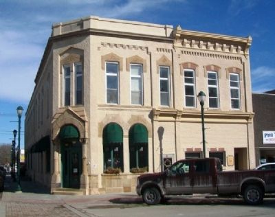
This lot, including the land west to the corner, was purchased for $22 dollars in 1849. From the mid-1880's until the early 1900's, O.D. Ames, then Joeckel Bros. Clothing stores were located in this building. Later, the John Catterlin Harness & . . . — — Map (db m72471) HM
In its early days, this building housed businesses selling jewelry, stationery and then drugs. A Gambels Store conducted business here from the 1930's until 1971 when Alexander Fabrics acquired the building and operated until 1996. It has also . . . — — Map (db m72472) HM
Drugs and Jewelry were sold from the wood frame building that originally stood here. The current building housed a succession of shoe stores for more than 100 years. Proprietors were Aikens, Allen, Stevens, and Hendricks.
In the early 1900's, . . . — — Map (db m72473) HM
Eli Cox, builder of several local covered bridges, had the contract to build this structure. During the construction, gas pipes were incorporated in anticipation of soon having a source for lighting. The Opera House was originally on the second . . . — — Map (db m72475) HM
Local covered bridge builder Eli Cox was the contractor for this building. Businesses have included dry goods, a harness shop, a bootery, a millinery, and an electric shop. The North Side Barber Shop has served Winterset's men since the 1930's. . . . — — Map (db m72509) HM
In the 1800's, agricultural implements were sold here. The Marsh Harvester advertised that "it saves the house-wife the unpleasant drudgery of providing for extra help, during the hottest season of the year" implying that extra farm hands would . . . — — Map (db m72510) HM
In 1874, in a wood frame building on this lot, Ho Cheung, a Chinese immigrant, ran A.R. Shong & Co., importers and dealers of tea and coffee. They also manufactured cigars and sold tobacco. The City Bakery was here in 1875. From 1885 through the . . . — — Map (db m72511) HM
This middle section of the building has been occupied by a bakery, drug stores, a pool hall, a dry cleaner, an engineering firm, and restaurants, including the Black and White Restaurant and the China Cafe.
In earlier years, the second floor . . . — — Map (db m72516) HM
In 1864 this was the site of Irish immigrant Andrew Crawford's wood-frame grocery store.
This building was erected with one main facade for three stores. Notice the matching second-story windows.
Some of the businesses housed in the east . . . — — Map (db m72517) HM
[Top photo caption reads]
This building was owned by Dr. O.L. Garlinghouse who had a medical practice on the second floor. Notice the awnings are on the side of the building facing the afternoon sun. Air conditioning was non-existent at this . . . — — Map (db m83548) HM
[Top photo caption reads]
These buildings were developed after 1910. During this period, there were a number of meat markets throughout Iola. With the lack of refrigeration, people had to buy fresh meat daily.
[Bottom photo caption reads] . . . — — Map (db m83551) HM
[Top photo caption reads]
East Side Cafe became Harts Lunch by the 1940s and was a local teenage hangout. Both restaurants were a favorite for homemade hamburgers and pies.
[Bottom photo caption reads]
Originally, this building had a carriage . . . — — Map (db m83545) HM
[Top photo caption reads]
This photo was taken looking north on Jefferson Avenue. The building on the corner was the 2nd building for the Allen County Courthouse in Iola. Notice the brick streets. Iola housed numerous brick plants during this . . . — — Map (db m83715) HM
The original Jefferson County Court House grounds Bandstand was constructed in 1906 and existed on the southwest corner of the court house grounds until it was destroyed in the 1960 tornado that also severely damaged the court house building. This . . . — — Map (db m63731) HM
The Blacksmith Shop building is new (1983), but houses tools that were used in late 1800's and early 1900's. Many of the tools are from Archie Brown's shop in McLouth. — — Map (db m63732) HM
Built in Cleveland, Ohio in 1875. Originally it crossed Rock Creek north of Meriden. It was relocated in the 1950's to southeast of Valley Falls. It was moved in 1975 to Old Jefferson Town. — — Map (db m63734) HM
The church building was completed in 1891 and was located 4 miles north of McLouth at the intersection of Union (Hwy 92) and 118th. It was a United Brethren Church and became Evangelical United Brethren (E.U.B.) in 1946 with the unification of the . . . — — Map (db m63747) HM
Dedicated to the citizens of Jefferson County to honor those who served in the Armed Forces and those who died for their country. — — Map (db m63730) WM
Native Kansas artist John Steuart Curry (1897 - 1946), best known for the murals he painted in the Kansas State Capital building, was born and raised in Jefferson County. John lived in the home until 1914. It was located 6 miles north of Oskaloosa . . . — — Map (db m63746) HM
The Kilgour School was formed in 1869. The building was located about 4 miles southwest of Oskaloosa and the the corner of 78th and Lincoln. It was moved to Oskaloosa in 1950 and became part of the elementary grade school complex (Grades 1-4), along . . . — — Map (db m63765) HM
The Plum Grove School District was formed in 1863. It was located about 5 miles northeast of Oskaloosa near 122nd & Saline. It was moved to Oskaloosa in 1950 and became part of the elementary grade school complex (Grades 1-4), along with Kilgour, . . . — — Map (db m63764) HM
Robert Wesley Reynolds (1847 - 1935) built his two story building on McLouth's Main Street in 1887 where it was used as a merchandise store. The porch was added when the building was moved to Old Jefferson Town in 1970. — — Map (db m63754) HM
Originally a one-room school building, 7 miles southeast of Oskaloosa )1/2 mile south of intersection of Republic and 54th). It was built in 1903 (28' X 44'), was moved to Oskaloosa in 1950 and used as part of Oskaloosa's elementary grade school . . . — — Map (db m63767) HM
The jail building was relocated from Winchester to Old JeffersonTown in 1977. The Winchester town police were more likely to use the jail as a sleep-over from drunks [than] to contain a criminal. It also served as a meeting place for city . . . — — Map (db m63748) HM
Fort Jefferson (also known as Camp Crittenden) was the second of two Union Army posts established in Ballard County in September 1861, following the Confederate occupation of Columbus. Fort Jefferson was first established during the American . . . — — Map (db m18493) HM
The story of the cross at Wickliffe began in 1937 when a few members of a community choir, spearheaded by Mrs. Noah Geveden, erected a small wooden cross on a hill at the Ancient Buried City (now known as Wickliffe Mounds Research Center) in . . . — — Map (db m113749) HM
Fort Jefferson Site Built in 1780 by George Rogers Clark as part of impressive plan of settlement, conceived by Gov. Patrick Henry of Virginia, later pursued by and named for Gov. Thomas Jefferson. The fort was to protect US claim to its . . . — — Map (db m18639) HM
Long before Lewis and Clark stopped near Wickliffe in western Kentucky on their outbound trip to the west, Fort Jefferson had been built in 1780-81 by George Rogers Clark during the Revolutionary War as an outpost against British-led Indian attacks. . . . — — Map (db m18548) HM
(North Side):Lewis and Clark in Kentucky Fort Jefferson Lewis and Clark and a party of eight men visited the site of Fort Jefferson on Nov. 18, 1803, while on their epic 1803-1806 journey to the Pacific. Fort est. in 1780 by Clark's . . . — — Map (db m18545) HM
For three years (1821-1824) while a student at Transylvania University Jefferson Davis (afterwards President of Southern Confederacy) lived here with Joseph Ficklin then Postmaster of Lexington. — — Map (db m35839) HM
The 294-acre Samuels property had been in the Samuels family since the late 1800's.
It was purchased from the family of Walter and Helen Samuels by Louisville Metro government in December, 2005. Thank you to the Samuels family and to our . . . — — Map (db m204270) HM
City and County Named. Louisville, at the Falls of the Ohio, was founded in 1778 by George Rogers Clark. Site first served as a military outpost; the city which developed was named for Louis XVI. Kentucky Co., Virginia, was divided in 1780 . . . — — Map (db m104581) HM
One of three original counties formed when Kentucky Co., Virginia, was divided by Va. Act in 1780. Other 2 counties were Lincoln and Fayette. Jefferson included 19 present-day counties; parts of 11 others. By 1811 reduced to present boundaries. . . . — — Map (db m205257) HM
( inscribed around the base )
This monument to Thomas Jefferson was presented to the people of Kentucky July 4 1900 by Isaac W and Bernard Bernheim to perpetuate the teachings and examples of the Founders of the Republic
( . . . — — Map (db m104579) HM
KOREAN WAR MEMORIAL
JUNE 25, 1950 - North Korean Communist troops crossed the 38th Parallel, invading South Korea. Within days, the South Korean capital of Seoul fell into Communist hands.
SEPTEMBER 15, 1950 - Allied troops make very . . . — — Map (db m35357) WM
April 3, 1798, is the university's symbolic founding date. On this date, eight Louisvillians pledged financial support for a new school. The 1798 benefactors were: William Croghan, Alexander S. Bullitt, James Meriwether, John Thruston, Henry . . . — — Map (db m161352) HM
To commemorate the merger
September 1, 1950
The Jefferson School of Law
and
The University of Louisville
The Jefferson School of Law was organized in 1905 and during the forty-six years of its separate existence conferred the . . . — — Map (db m244646) HM
Built in 1797, this building was purchased by Jefferson Marders, one of Middletown's early merchants, in 1837. Two of the original, dry stack stone rooms and the arched fireplace remain as part of the foundation of the existing building. — — Map (db m203178) HM
Rocky Hill, one mile north, home
of Lucy Jefferson Lewis, youngest
sister, Thomas Jefferson author
of Declaration of Independence
and third president of U. S. She
was born in 1752, Albemarle Co.,
Va. Came to Ky., 1808, with her
husband Dr. . . . — — Map (db m170133) HM
July 9, 1862, Morgan's Raiders, coming from Tenn. on first raid into Ky., attacked force of 9th Pa. Cav. at USA garrison. Raiders captured 30 of retreating enemy and destroyed tents and stores. They took 20 wagons, 50 mules, 40 horses, sugar and . . . — — Map (db m39573) HM
Here the only President of the Confederate States of America was born June 3, 1808, the son of Samuel and Jane Cook Davis. The family moved to Mississippi during his infancy. — — Map (db m3032) HM
"Kentucky, my own, my native land. God grant that peace and plenty may ever run throughout your borders. God grant that your sons and daughters may ever rise to illustrate the fame of their dead fathers and that wherever the name of Kentucky is . . . — — Map (db m3035) HM
Zero Milestone
Jefferson Davis Highway
Fairview, Ky. - Biloxi, Miss.
Erected 1930 by
United Daughters of the Confederacy
Jefferson Davis
Born June 3, 1808
in Christian, now Todd Co. KY.
Died December 6, 1889
in New Orleans, . . . — — Map (db m3034) HM
The Texas and Pacific Railway established a
station on the main line at Bunkie in 1882. The
current depot, built in 1911 and listed on the
National Register of Historic Places, is the only
existing reminder of the importance of the
railway to . . . — — Map (db m208821) HM
Built 1922 as a railroad hotel-- Union Depot stood across the street for many years. Extensively restored and remodelled in 1980s. Listed in National Register of Historic Places, 1989. — — Map (db m139874) HM
Actor, Author and Artist
Designed and built this home in 1870
Rip Van Winkle Gardens
Named for the character which he
immortalized and which in his day
made him America's most celebrate actor — — Map (db m198865) HM
Once known as Orange Island purchased after the Civil War by Joseph Jefferson (1829 to 1905), world famous actor and artist. Home designed and built about 1870. — — Map (db m105148) HM
Named for George Augustus Waggaman, prominent politician, planter and War of 1812 veteran. His plantation, Avondale, was built north of here in 1839. Home consumed by Miss. River in early 1900s. — — Map (db m81061) HM
On Feb. 11, 1825, Governor Henry S. Johnson signed legislation creating the Parish of Jefferson out of the Third Senatorial District. It is named for President Thomas Jefferson, who died the following year, July 4. — — Map (db m148816) HM
During 1930-42 this airport operated passenger, charter, and mail service and a flying school. The company of James R. Wedell and Harry P. Williams designed, built and flew some of the fastest planes in the world. Wedell set a world speed record in . . . — — Map (db m93112) HM
Two miles N.E. on Grand Terre. Land occupied by Jean Lafitte until 1814, purchased by U.S. from Etienne DeGruy in 1834. Fort constructed 1841 to defend Barataria Pass. Site never saw combat. Abandoned after the War Between the States, guns were . . . — — Map (db m100013) HM
At Southernmost tip of Jefferson Parish, Louisiana's only inhabited barrier island appears in 18th century land-grants. At first part of Orleans Territory, but often administered by Lafourche Parish. Officially part of Jefferson Parish since 1825. . . . — — Map (db m100149) HM
On Feb. 11, 1825, Governor Henry S. Johnson signed legislation creating the Parish of Jefferson out of the Third Senatorial District. It is named for President Thomas Jefferson, who died the following year, July 4. — — Map (db m100007) HM
Home of Pierre A.C.B. Derbigny, 6th Governor of La., 1828~1829, member 1st La. Legislature, La. Secretary of State, La. Supreme Court Judge, Battle of N.O. veteran. 1820 operated 1st steam ferry on Miss. River at N.O. Died 1829 from a carriage . . . — — Map (db m80975) HM
Built in 1907 as the sixth
Jefferson Parish Courthouse
Annex added 1929
Dedicated Gretna City Hall 1964
National Register of Historic Places 1983 — — Map (db m81107) HM
Founded 1815 by education philanthropist John McDonogh. Also known as Freetown where his freed slaves settled and Gouldsboro for railroad magnate Jay Gould. Incorporated 1913 into City of Gretna. — — Map (db m80976) HM
Approx. 200 feet SW of this site, cast first gun for the Confederate Navy on 4 May 1861. The gun, a Dalhgren cannon, fired an 8~inch diameter explosive shell. Sylvester Bennett was proprietor. — — Map (db m81063) HM
Community est. 1914 by Illinois Central Railroad. Named for James Harahan, RR President, 1906-1911. Village incorporated 1920. City incorporated 1953. Francis William Mayo, First Mayor, 1920-1922. — — Map (db m93086) HM
Site of plantation acquired in 1808 by Joseph Soniat du Fossat. Visited by Governor William C.C. Claiborne and, legend says, privateer Jean Lafitte. "Chapitoulas" Indians, whose name means "river people," lived in this area. — — Map (db m93056) HM
Built in 1844, Harvey Castle was the Gothic Revival home of Marie Louise Destrehan and her husband Joseph Hale Harvey. It served as the third courthouse of Jefferson Parish, 1874-1884. Located east side of Destrehan Avenue 450 feet north of . . . — — Map (db m52725) HM
Originally Destrehan Canal, dug before 1845, connecting Mississippi River to Bayou Barataria. "Submarine Railway" lifted boats over the levee until successful completion of locks in 1907. Became part of Gulf Intracoastal Waterway in 1924. — — Map (db m80971) HM
Named for legendary privateer Jean Lafitte, who helped the United States win the Battle of New Orleans and used area bayous for his smuggling operations. Home to a thriving seafood industry. Incorporated in 1974 as a village. Became a town in 1977. . . . — — Map (db m109936) HM
Joseph Villars Dubreuil settled here in 1719. He became a pioneer in agriculture and wealthy entrepreneur. Nearby he built the first plantation levee. It led to the creation in 1724 of the Mississippi River's original levee system. — — Map (db m86102) HM
Named for U.S. President Thomas Jefferson. Completed 4 Feb. 1926. "Pine to Palm" route, one of first intercontinental highways. Extends 2,194 miles from Winnepeg, Canada, through Jefferson, ending in New Orleans at St. Charles Ave. and Common St. . . . — — Map (db m100376) HM
Opened at 110 Shrewsbury Road in 1944 to serve African Americans during segregation. Proprietor Ellis L. Marsalis, Sr., was Jazz musician family patriarch & Civil Rights pioneer. Closed in 1986. — — Map (db m104702) HM
Built in 1857 for François Pascalis de Labarre IV. Occupied by Union Troops during the Civil War. After 1892 was a gambling casino, Jesuit retreat house and St. Agnes Church. Magnolia School since 1935. — — Map (db m125236) HM
Zone between les Chapitoulas and the Demeuves Concession. 5 leagues above New Orleans along the Mississippi River. From 1708–1819, this name was in use under French, Spanish, and American rule. Site of present day Kenner. — — Map (db m86098) HM
Named for Kenner brothers George R., Minor, Duncan Farrar, & William Butler, who acquired Oakland, Pasture, & Belle Grove plantations, 1830s-40s. Area subdivided in 1855 as Kennerville with arrival of railroad. Replaced colonial name of Cannes . . . — — Map (db m94073) HM
On Feb. 11, 1825, Governor Henry S. Johnson signed legislation creating the Parish of Jefferson out of the Third Senatorial District. It is named for President Thomas Jefferson, who died the following year, July 4. — — Map (db m185107) HM
Part of the Jean Lafitte National Historic Park and Preserve with 23,000 acres of wetlands. Park was created in 1978 due to persistence of educator and environmentalist Frank John Ehret, Jr. — — Map (db m109427) HM
To guard New Orleans, Spain in 1779 settled 56 families from the Canary Islands on lands starting at Crown Point. Flooding by the Mississippi River forced most of the settlers to relocate in 1782. Efforts to resettle failed and finally ceased in . . . — — Map (db m81095) HM
A 12-square-mile area incorporated as a village in June 1927 and as a city one month later. Charles P. Aicklen, Sr., mayor, introduced natural gas service, July 1928. Gambling was flourishing, but was outlawed within the city limits. Incorporation . . . — — Map (db m93550) HM
Lafreniere orated before the Louisiana Superior Council "The Manifeste" a document expressing the political philosophy on the natural rights of man and freedom of determination by the people. A firing squad executed him with 4 compatriots in . . . — — Map (db m112793) HM
On Feb. 11, 1825, Governor Henry S. Johnson signed legislation creating the Parish of Jefferson out of the Third Senatorial District. It is named for President Thomas Jefferson, who died the following year, July 4. — — Map (db m193381) HM
Named for the de La Barre family. François Pascalis de La Barre I, a noted colonial official, owned a river-to-lake tract in 1750. Further family holdings, by 1800's, made Metairie called popularly "La Plaine Labarre." — — Map (db m93111) HM
Part of the concession in 1720 by Governor Bienville to father of Nicholas Chauvin LaFreniere, Attorney-General of Louisiana for the years 1763 until 1769. Leader of the revolt against Spanish rulers of Louisiana, and executed October 25, 1769. — — Map (db m93902) HM
On Feb. 11, 1825, Governor Henry S. Johnson signed legislation creating the Parish of Jefferson out of the Third Senatorial District. It is named for President Thomas Jefferson, who died the following year, July 4. — — Map (db m112786) HM
The site of this park once belonged to the River-to-Lake Sainte-Reyne Concession granted to Jean-Daniel Kolly, c. 1720. A series of purchases subdivided the original property except for this 155-acre park. Nicolas Chauvin de Lafreniere, the . . . — — Map (db m112787) HM
On Feb. 11, 1825, Governor Henry S. Johnson signed legislation creating the Parish of Jefferson out of the Third Senatorial District. It is named for President Thomas Jefferson, who died the following year, July 4. — — Map (db m170474) HM
Concession 1720's-1730's On the old Chemin de la Metairie Birthplace Jacques Phillipe Roi de Villeré 1761-1830 First native born Governor of Louisiana 1816-1820 — — Map (db m93237) HM
On Feb. 11, 1825, Governor Henry S. Johnson signed legislation creating the Parish of Jefferson out of the Third Senatorial District. It is named for President Thomas Jefferson, who died the following year, July 4. — — Map (db m81065) HM
1960 Paul Kapelow prefab diamond-shaped development with alphabetical street plan named for daughter Terry. Area's "first completely winter~summer air conditioned neighborhood." — — Map (db m80979) HM
Formerly Petit Desert, a 1719 concession. Among first parish settlements, it was a trading post and major entry port of the Louisiana colony. 1794 Michael Zeringue established Seven Oaks Plantation. His son, Camille, built Greek Revival style main . . . — — Map (db m81062) HM
Architectural Style: Eclectic Revival & Craftsman
Joseph S. Petro, Sr. and Florida Dominique Petro built this
house after many years of success with their Freetown grocery
store and rental properties. They owned and operated their
grocery . . . — — Map (db m236704) HM
Born at Fairview, KY. June 3, 1808
U.S. Army 1828-1835
Served in Black Hawk War
Congressman U.S. 1845-1846
Colonel Mississippi Volunteers in War with Mexico
Rendered Gallant Service in the taking of Monterey and Buena Vista where he was . . . — — Map (db m51521) HM
Pierre Chartier de Baulne, French Louisiana attorney general in 1719, held the earliest land grant at the former village of the Colapissas on Chapitoulas (Metairie) Road. His family first colonists to live nearby. — — Map (db m92953) HM
Originally a part of Jefferson Parish, this area was incorporated as Jefferson City in 1850. By 1860 its population was 5,107, including 131 free black citizens. It was annexed by the City of New Orleans in 1870. — — Map (db m13039) HM
Jefferson F. Davis was born in Kentucky June 3, 1801. In 1810 his family moved to St. Mary Parish settling on Bayou Teche. He graduated West Point, was a hero of The Mexican War, a US Representative, Senator, Secretary of War, and Regent of the . . . — — Map (db m86626) HM
Enter another world one that had existed in the Chesapeake Bay region long before Europeans came to settle here. Follow this trail to a re-created Native American Village, where you will learn about the Eastern Woodland people who lived . . . — — Map (db m80922) HM
Welcome to Jefferson Patterson Park and Museum (JPPM), State Museum of Archaeology, where we explore the changing cultures and environment of the Chesapeake Bay region over the past 12,000 years.
You can investigate the thousands of years of human . . . — — Map (db m80923) HM
Cobb’s Brigade McLaw’s Division C.S.A. ——•••—— At 1 P.M. on September 14, 1862, Cobb’s Brigade under Gen. Howell Cobb of Athens, GA. marched from Sandy Hook to Brownsville at the west foot of . . . — — Map (db m1964) HM
3479 entries matched your criteria. Entries 201 through 300 are listed above. ⊲ Previous 100 — Next 100 ⊳
* Inflectional forms of words are their plurals, singulars, and possessives as well as gramatical tenses and similar variations.