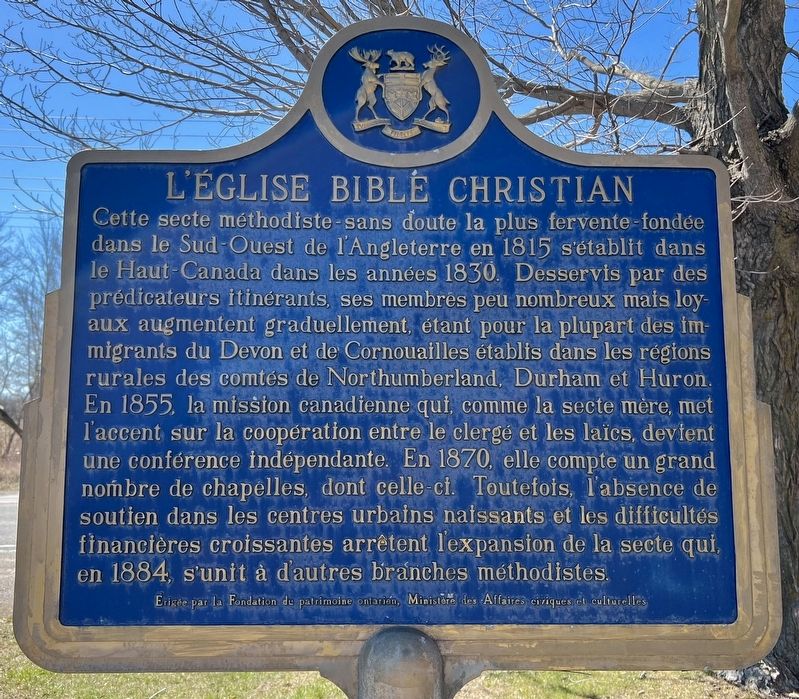
On Courtice Road at Bloor Street, on the right when traveling north on Courtice Road.
Perhaps the most fervent of the Methodist sects, the Bible Christian Church was formed in southwestern England in 1815 and established in Upper Canada during the 1830s.
Served by itinerant preachers, its small but loyal memberShip . . . — — Map (db m245216) HM
On Mill Street South at Edward Street West, on the right when traveling south on Mill Street South.
An outstanding humanitarian and churchman, Brent was born near Newcastle and ordained in Toronto in 1887. Following parochial service in Buffalo and Boston, he was elected first Episcopal Bishop of the Philippine Islands in 1901. Confronted by the . . . — — Map (db m284029) HM
On Temperance Street at Church Street, on the right when traveling south on Temperance Street.
When war was declared by Great Britain in 1914, recruitment of Canadian troops soon followed. This mural depicts the ceremony as the town's first volunteers marched off with great pride to board the trains for Halifax. The 136th Battalion spent the . . . — — Map (db m245080) HM WM
On Wellington Street at Silver Street, on the right when traveling west on Wellington Street.
Central Public School was not the initial building to occupy this site. The first building was a two story frame structure built about 1840 as Bowmanville's first court house and town hall.
In 1855, as an improvement to education, an assortment . . . — — Map (db m245076) HM
On Wellington Street at Silver Street, on the right when traveling west on Wellington Street.
Central Public School
Tower Bell
Established 1889 restored on this site
in recognition of the outstanding
educational contributions by
Tom Turner
Principal 1954-1983
June 28. 1983 — — Map (db m244817) HM
On Church Street at Temperance Street, on the right when traveling east on Church Street.
Prior to moving to Church Street, Bowmanville's first fire hall
stood in the location of our present Town Hall. With no horse team of their own, a $10.00 reward was offered to the owner of the first team of horses to arrive at the hall during a . . . — — Map (db m245133) HM
On Temperance Street at Church Street, on the right when traveling south on Temperance Street.
This structure is the third to be used as a town hall in Bowmanville's history. The
first was on the site of Central Public School (NW corner of Elgin and Wellington). It was a large wooden building that also served as a court house and school. . . . — — Map (db m245078) HM
On Mill Street South at Boulton Street, on the right when traveling south on Mill Street South.
The first European settlers in Clarke Township were the Lovekins and the Bates arriving within weeks, possibly days, of one another.
Richard Lovekin Sr. arrived from County Cork, Ireland, via the United States and Niagara-on-the-Lake early in . . . — — Map (db m244742) HM
On King Avenue East 0.1 kilometers Beaver Street North, on the left when traveling east.
One of Canada's leading publishers, Joseph Atkinson was born here in Clarke Township and, at eighteen, began his journalistic career with the Port Hope Times. He subsequently moved to Toronto where he was employed first with the World and later the . . . — — Map (db m244766) HM
On King Street East at Division Street, on the left when traveling west on King Street East.
Originally known as Darlington Mills, Bowmanville was founded in 1794 when an American family of Loyalists settled near the site of Vanstone's Mill. The first businesses were established in the river valley south of the mill but are now gone. . . . — — Map (db m245101) HM
On Temperance Street at King Street West, on the right when traveling south on Temperance Street.
An ardent Canadian and founder of the Canadian Club movement, McCullough was born in Bowmanville and moved to Hamilton in 1888. He and four companions in December, 1892, determined to found an organization which would encourage the study of Canada's . . . — — Map (db m245082) HM
On Temperance Street at King Street West, on the right when traveling north on Temperance Street.
With Mr. Levi Tole conducting auction sales & hawkers of patent medicines pitching their wares, the Church & Temperance St. or Market Square, was a busy centre of downtown activity. On the edge of the square was the town pump. This was a popular . . . — — Map (db m245097) HM
On King Avenue East at Beaver Street South on King Avenue East.
The Masseys at Newcastle
One of the world's largest manufacturers of heavy farm machinery, Massey-Ferguson has its foundations in a modest family business developed in Newcastle. Established in Bond Head by Daniel Massey, the . . . — — Map (db m244762) HM
On Durham Regional Highway 2 0.2 kilometers east of Cobbledick Road, on the right when traveling west.
On this site in 1866 Samuel Wilmot began to experiment with the artificial breeding of salmon. His success led the federal government in 1868 to enlarge Wilmot’s project into Ontario's first full scale fish hatchery, one of the earliest in North . . . — — Map (db m244767) HM
On Old Kingston Road 0.2 kilometers east of Durham Highway 2, on the right when traveling east.
This cairn marks the site of a late 19th century grist mill and miller’s house. The stones are from the foundation of the miller’s house.
In 1874 Jacob Stalter built a mill pond, just north of this site, close to the junction of the Black & . . . — — Map (db m245538) HM
On Church Street 0.1 kilometers west of Temperance Street, on the right when traveling west.
This once prestigious property, the 'Rathskamory Estate' was the residence of Dr. George Lowe. With its well groomed gardens surrounded by stately beech, maple & elm trees, this beautiful ten acre property lay between Lowe & Concession Streets. Also . . . — — Map (db m245208) HM
On Concession Road 7 0.5 kilometers west of Liberty Street North, on the right when traveling west.
Robert McLaughlin, a pioneer of the Canadian vehicle industry, was born in the family homestead on this property. In 1867, despite lack of technical training, he built two cutters in his driving-shed which stood near this site. His business . . . — — Map (db m244813) HM
On Temperance Street at Church Street, on the right when traveling north on Temperance Street.
Both St. Andrew & St. Paul's Churches derive their roots from the same early Presbyterian congregation which began holding formal services in 1843. The first St. Andrew's Church, a small frame building, was opened here in 1842 on a parcel of land . . . — — Map (db m245123) HM
On Old Kirby School Road at Ganaraska Road, on the left when traveling north on Old Kirby School Road.
A distinguished authority on tropical diseases, Stanton was born near here and educated at Trinity Medical College, Toronto. In 1907, after serving as house surgeon at the Hospital for Tropical Diseases in London, England, he accepted a . . . — — Map (db m244768) HM