37 entries match your criteria.
Related Historical Markers
By Ray King, June 7, 2011
William Bartram's Plantation Marker
SHOWN IN SOURCE-SPECIFIED ORDER
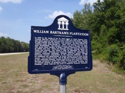
| 1 ► Florida, St. Johns County, Green Cove Springs — F-514 — William Bartram's Plantation — |
| On State Road 16, 0.8 miles west of State Road 13 (State Road 13), on the right when traveling east. | |||
| 2 ► Georgia, Richmond County, Augusta — 121-7 — William Bartram Visited Augusta, 1773. — |
| Near E. Ford Street near Telfair Street. | |||
| 3 ► Florida, St. Johns County, Switzerland — William Bartram Scenic Highway — |
| On State Road 13, on the left when traveling north. | |||
| 4 ► Alabama, Elmore County, Wetumpka — William Bartram Arboretum — 1739 - 1823 — |
| Near West Fort Toulouse Road, 0.2 miles south of Jackson Park Road. | |||
| 5 ► Florida, Alachua County, Micanopy — F-75 — William Bartram — (1739-1823) — |
| On NE Cholokka Blvd (County Road 234), on the left. | |||
| 6 ► Florida, Alachua County, Newberry — William Bartram Trail — Traced 1773 - 1777 — Deep South Region — |
| On US Hwy 27 & 41 (U.S. 27) at Northwest 16th Avenue, on the right when traveling north on US Hwy 27 & 41. | |||
| 7 ► Florida, Marion County, Salt Springs — William Bartram Trail — Traced 1773 - 1777 — Deep South Region — |
| On State Road 19, 0.2 miles south of County Road 316 (County Road 316), on the right when traveling south. | |||
| 8 ► Florida, Nassau County, Fernandina Beach — William Bartram Trail — Traced 1773-1777 — Deep South Region — |
| On S Front Street near Centre Street, on the right when traveling north. | |||
| 9 ► Florida, Putnam County, East Palatka — William Bartram Trail — Deep South Region — Traced 1773 - 1777 — |
| On U.S. 17, on the right when traveling south. | |||
| 10 ► Florida, Putnam County, Palatka — William Bartram Trail — Traced 1773-1777 — Deep South Region — |
| Near Twigg Street near Moseley Avenue. | |||
| 11 ► Florida, St. Johns County, Picolata — William Bartram Trail — Traced 1773-1777 — Deep South Region |
| On County Road 13, 0.5 miles north of County Road 208, on the right when traveling south. Reported missing. | |||
| 12 ► Florida, St. Johns County, Switzerland — William Bartram Trail — Traced 1773 - 1777 — Deep South Region — |
| On William Bartram Scenic Highway (State Road 13), on the left when traveling north. | |||
| 13 ► Florida, Seminole County, Longwood — William Bartram Trail — Traced 1773-1777 — Deep South Region — |
| Near Interstate 4 at milepost 96,, 2.5 miles east of State Road 434, on the right when traveling east. | |||
| 14 ► Florida, Volusia County, Volusia — William Bartram Trail — Traced 1773-1777 — Deep South Region — |
| On State Road 40 at Alice Drive, on the right when traveling west on State Road 40. | |||
| 15 ► Georgia, Bibb County, Macon — William Bartram Trail — Traced 1773–1777 — Deep South Region — |
| On the park road south of Emery Highway (U.S. 80). | |||
| 16 ► Georgia, Bibb County, Macon — William Bartram Trail — Traced 1773-1777 — |
| On Colonial Station Drive, 0 miles south of Columbus Road, on the right when traveling south. | |||
| 17 ► Georgia, Chatham County, Savannah, Historic District - North — William Bartram Trail — Traced 1773-1777 — Deep South Region — |
| On W. River Street near N. Barnard St., on the left. | |||
| 18 ► Georgia, Athens-Clarke County, Athens — William Bartram Trail — Traced 1773-1777 — Deep South Region — |
| On the State Botannical Garden entrance road, 0.2 miles west of S. Milledge Avenue, on the right when traveling west. | |||
| 19 ► Georgia, Crawford County, Knoxville — William Bartram Trail — Traced 1773-1777 — Deep South Region — |
| On East Agency Street (Georgia Route 42) at Hartman Mill Road, on the right when traveling west on East Agency Street. | |||
| 20 ► Georgia, Crawford County, Sandy Point — William Bartram Trail — Traced 1773-1777 — Deep South Region — |
| On Carl Sutton Road, 0.4 miles north of Sandy Point Road, on the right when traveling north. | |||
| 21 ► Georgia, Effingham County, Rincon — William Bartram Trail — Traced 1773-1777 — Deep South Region — |
| On Ebenezer Road (Route 275) near Old Augusta Road (County Route 284), on the left when traveling north. | |||
| 22 ► Georgia, Glynn County, St. Simons Island — William Bartram Trail — Traced 1773-1777 — Deep South Region — |
| On Mimosa Dr, on the left when traveling west. | |||
| 23 ► Georgia, Liberty County, Riceboro — William Bartram Trail — Traced 1773-1777 — Deep South Region — |
| On Barrington Ferry Road, 1 mile south of Sandy Run Road. | |||
| 24 ► Georgia, Lincoln County, Lincolnton — William Bartram Trail — Traced 1773-1777 — Deep South Region — |
| On Coach Jimmy Smith Highway (U.S. 378) at Old Petersburg Road (Georgia Route 43 Conn), on the right when traveling east on Coach Jimmy Smith Highway. | |||
| 25 ► Georgia, Madison County, Danielsville — William Bartram Trail — Traced 1773 – 1777 — Deep South Region — |
| On Old Wildcat Bridge Road (County Route 399) at John Conant Drive, on the left when traveling east on Old Wildcat Bridge Road. | |||
| 26 ► Georgia, Marion County, Buena Vista — William Bartram Trail — Traced 1773-1777 — Deep South Region — |
| On State Highway 41 at County Route 56, on the left when traveling north on State Highway 41. | |||
| 27 ► Georgia, McDuffie County, Thomson — William Bartram Trail — Traced 1773-1777 — Deep South Region — |
| On Wrightsboro/Stagecoach Road, 4 miles west of U.S. 78, on the left when traveling west. | |||
| 28 ► Georgia, McIntosh County, South Newport — William Bartram Trail — Traced 1773-1777 — Deep South Region — |
| On Coastal/Ocean Highway (U.S. 17), on the right when traveling south. | |||
| 29 ► Georgia, Muscogee County, Columbus — William Bartram Trail — Traced 1773-1777 — Deep South Region — |
| On Broadway at Fourth Street, in the median on Broadway. | |||
| 30 ► Georgia, Oglethorpe County, Arnoldsville — William Bartram Trail — Traced 1773-1777 — Deep South Region — |
| On Athens Road (U.S. 78) at Moss Creek Road, on the right when traveling west on Athens Road. | |||
| 31 ► Georgia, Rabun County, Clayton — William Bartram Trail — Traced 1773-1777 — Deep South Region — |
| On Warwoman Road (County Route 219) 2.7 miles east of U.S. 441, on the right when traveling east. | |||
| 32 ► Georgia, Richmond County, Augusta — William Bartram Trail — Traced 1773-1777 — Deep South Region — |
| Near 8th Street. | |||
| 33 ► Georgia, Talbot County, Talbotton — William Bartram Trail — Traced 1773-1777 — Deep South Region — |
| On Georgia Route 41 at Clark Street (Route 90), on the right when traveling north on State Route 41. | |||
| 34 ► Georgia, Taylor County, Butler — William Bartram Trail — Traced 1773-1777 — Deep South Region — |
| On Georgia Route 137 at Fickling Mill Road, on the right when traveling west on State Route 137. | |||
| 35 ► North Carolina, Macon County, Topton — Q-44 — William Bartram — |
| On U.S. 74, on the right when traveling east. | |||
| 36 ► South Carolina, Abbeville County, Abbeville — William Bartram Trail — Traced 1773-1777 — South Atlantic Region — |
| On State Highway 71, 0.5 miles east of County Road 1-63. | |||
| 37 ► South Carolina, Horry County, Myrtle Beach — William Bartram Trail — Traced 1773–1777 — South Atlantic Region — |
| On Ocean Boulevard (State Highway 73) at South 20th Avenue, on the right when traveling north on Ocean Boulevard. | |||