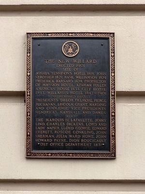
Site of
Joshua Tennison's Hotel 1818. John Strother 1821. Basil Williamson 1824. Frederick Barnard 1828. Proprietor of Mansion Hotel, Azariah Fuller American House 1833. City Hotel 1843. Willard's Hotel 1847-1901.
Distinguished Guests . . . — — Map (db m6618) HM
The United States Court of Claims held its first meeting in "Willard's Hotel" on this site on May 11, 1855. The court was established to allow citizens to sue the U.S. Government. In 1861, President Lincoln wrote of the court:
"It is as . . . — — Map (db m6587) HM
"This hotel, in fact, may be much more justly called the center of Washington and the Union than either the Capitol, the White House, or the State Department...."
Nathaniel Hawthorne, Civil War reporter for The Atlantic . . . — — Map (db m211824) HM
"This hotel, in fact, may be much more justly called the center of Washington and the Union than either the Capitol, the White House, or the State Department...."
Nathaniel Hawthorne, Civil War reporter for the Atlantic . . . — — Map (db m10905) HM
It’s the summer of 1862. Early morning, but already hot and dusty. You’re standing at this spot, when you see a tall man on horseback. It’s President Abraham Lincoln. You’re pleased to see him, but not surprised. After all, he rides by here . . . — — Map (db m130757) HM
"No nation perhaps had ever before the opportunity offer'd them of deliberately deciding on the spot where their Capital city should be fixed..." - Peter C. L'Enfant to George Washington, September 11, 1789
A new nation . . . — — Map (db m60127) HM
To the gallant sons of Onondaga County, N.Y. who fought on this field July 12, 1864 in defence of Washington and in the presence of Abraham Lincoln
122 N.Y.V. — — Map (db m76093) WM
To your right is "Point Reno," the highest point in Washington — 409 feet above sea level, to be exact.
This unsurpassed vantage brought the Civil War (1861-1865) to Tenleytown. After the Union defeat at Bull Run in July 1861, . . . — — Map (db m130923) HM
This imposing property once belonged to Anacostia’s most famous resident: Frederick Douglass. After escaping slavery as a young man, Douglass rose to become a distinguished abolitionist, writer, publisher, and orator. By the 1860s Douglass was . . . — — Map (db m88723) HM
Ann G. Sprigg ran a boarding house, where Abraham Lincoln lived during his time as a U.S. Representative from Illinois (March 4th 1847 to March 3rd, 1849), at the present-day site of the Library of Congress Jefferson Building. The Sprigg . . . — — Map (db m211910) HM
The Neighborhood
This site has been associated with Navy medicine since 1800 when an apothecary shop located here provided medical services to sailors and marines from the nearby Navy Yard and Marine Barracks.
Naval Hospital, . . . — — Map (db m127966) HM
The body of John Wilkes Booth, assassin of President Abraham Lincoln, was brought to the Navy Yard for examination and identification aboard the USS Montauk. With the exception of Mary Surratt, the Lincoln conspirators (including Lewis Payne, . . . — — Map (db m126460) HM
“Although a soldier by profession, I have never felt any sort of fondness for war, and I have never advocated it, except as a means of peace,” General Ulysses S. Grant.
Hiram Ulysses Grant, mistakenly listed as Ulysses Simpson . . . — — Map (db m29459) HM
In 1829, the Federal Penitentiary was built on this site. Designed by Charles Bulfinch, the Architect of the Capitol, the Penitentiary was influenced by the prison reform movement of the 1820s. In 1831, an eastern extension to the building added a . . . — — Map (db m64922) HM
On April 14, 1865 John Wilkes Booth (of Maryland) assassinated President Abraham Lincoln at Fords Theater in downtown Washington. Booth's conspirators were arrested and tried by a Military Court here in Building 20 from May 9 to June 30, 1865. One . . . — — Map (db m29740) HM
"…in view from the windows of the Capitol, a sort of negro-livery stable, where droves of negroes were collected, temporarily kept, and finally taken to Southern markets …had been openly maintained for fifty years." Abraham . . . — — Map (db m129921) HM
During the Civil War, President Lincoln greeted troops upon arriving at the Southwest Waterfront, including Union Soldiers on their way to Fort Stevens to defend Washington from a Confederate Attack. — — Map (db m183749) HM
Fort Leslie J. McNair, to your right, honors the commander, Army Ground Forces during World War II who died in battle. It is the U.S. Army’s third oldest installation (after West Point and Carlisle Barracks).
The fort dates back to 1791. . . . — — Map (db m130912) HM
To your left across Water Street is the Thomas Law House, now a community center for the Tiber Island cooperative. The Federal style house was designed by William Lovering in 1794 for businessman Thomas Law and his bride Eliza Parke Custis, . . . — — Map (db m130911) HM
Gen. Ulysses S. Grant used this side-wheel steamer as his private dispatch boat, and it hosted the Hampton Roads Conference, President Lincoln's unsuccessful attempt to negotiate an end to the Civil War. — — Map (db m112443) HM
On June 18, 1861, T.S.C. Lowe made a tethered observation flight with his gas-filled balloon Enterprise from a spot on the National Mall in front of where the National Air and Space Museum now stands. During this flight, he sent the first telegram . . . — — Map (db m140624) HM
Named in honor of USDA's founder, President Abraham Lincoln, who described USDA as "The People's Department," People's Gardens demonstrate how people can be empowered to change their communities by the simple act of gardening.
The . . . — — Map (db m211342) HM
Four score and seven years ago our fathers brought forth on this continent, a new nation, conceived in Liberty, and dedicated to the proposition that all men are created equal.
Now we are engaged in a great civil war, testing whether that . . . — — Map (db m142392) HM WM
The grateful citizens and community of Clay County remember those who served in the arm forces of the United States during times of war and peace. Whose courage and personal sacrifices defended and preserved our liberty.
Four score and seven years ago our fathers brought forth on this continent, a new nation, conceived in Liberty, and dedicated to the proposition that all men are created equal.
Now we are engaged in a great civil war, testing whether that . . . — — Map (db m143358) WM
Abraham Lincoln’s Gettysburg Address was given as part of the dedication ceremony for a soldier’s cemetery. The cemetery was carved from a field at Gettysburg, Pennsylvania, where armies clashed in 1863 during the Civil War. The dedication, held . . . — — Map (db m142617) HM
The Third Union invasion was significant because it was the first deployment of African American troops in Florida by the federal government. The 33rd USCT (United States Colored Troops), formerly known as the 1st South Carolina Colored Infantry . . . — — Map (db m143682) WM
The Afro-American Insurance Company, formerly the Afro-American Industrial and Benefits Association, was founded in 1901 to provide affordable health insurance and death benefits to the state's African-Americans. Founded by the Reverend E.J. Gregg, . . . — — Map (db m59633) HM
April 12, 1865
Fort Sumter Attacked
July 21, 1861
1st Battle Of Bull Run
April 6, 1862
Battle Of Shiloh
August 29, 1862
2nd Battle Of Bull Run
September 17, 1862 . . . — — Map (db m152441) WM
1 • Mount Vernon Red Maple Planted in honor of the Founders of the City of Sanford, Florida on February 10, 1992. This red maple has been grown from seeds collected at Mount Vernon, President George Washington's beloved home on the . . . — — Map (db m214875) HM
Four score and seven years ago our fathers brought forth on this continent, a new nation, conceived in Liberty, and dedicated to the proposition that all men are created equal.
Now we are engaged in a great civil war, testing whether that . . . — — Map (db m144126) HM WM
Four score and seven years ago our fathers brought forth on this continent, a new nation, conceived in Liberty, and dedicated to the proposition that all men are created equal.
Now we are engaged in a great civil war, testing whether that . . . — — Map (db m146016) WM
Near this site on November 7, 1864 General Sherman received orders from President Lincoln and General Grant to proceed with his plans to march his army from Atlanta to the sea. Thus, the infamous March to the Sea originated in Kingston. This action . . . — — Map (db m35011) HM
Soldiers battled fatigue, thirst, and cold On the night of September 19, 1863, when the first day of bloody fighting had ended, the two armies re-grouped and planned their strategy for the next day. The Federal left withdrew to a line which . . . — — Map (db m62930) HM
For, Savannah, Christmas 1864 was anything but a time
for merriment. Almost four years of war had taken the
lives of thousands of Georgians, destroyed millions of
dollars in property and left the state in chaos. As the
holiday approached, so . . . — — Map (db m19422) HM
On January 12, 1865, U.S. Secretary of War Edwin Stanton and General Wm. T. Sherman met here at the home of Charles Green with 20 leaders from Savannah’s African-American churches, including Garrison Frazier, Ulysses L. Houston, and William . . . — — Map (db m40696) HM
One of two native Georgians who served as generals in the U.S. Army during the Civil War, John C. Frémont was born nearby on January 21, 1813. As an army officer, his 1840s explorations of the American West gained him fame as the . . . — — Map (db m62765) HM
Four score and seven years ago our fathers brought forth on this continent, a new nation, conceived in liberty, and dedicated to the proposition that all men are created equal.
Now we are engaged in a great civil war, testing whether that . . . — — Map (db m114679) HM WM
The Battle of Brown's Mill killed or wounded about 100 of McCook's men. Wheeler's casualties probably numbered fewer than 50. "The dead lay around us on every side, singly and in groups and piles; men and horses, - in some cases, apparently . . . — — Map (db m94668) HM
One mile north, on December 9, 1864, during the American Civil War, U.S. Gen. Jeff. C. Davis crossed Ebenezer Creek with his 14th Army Corps as it advanced toward Savannah during Gen. William T. Sherman’s March to the Sea. Davis hastily removed the . . . — — Map (db m31226) HM
Mr. Lincoln says we are free. We can live our own lives. God bless Mr. Lincoln. In 1863, as a strategy to end the Civil War, President Abraham Lincoln signed the Emancipation Proclamation declaring that "all persons held as slaves, . . . — — Map (db m168805) HM
This marker and plaza proudly acknowledges the significant contributions of John William Morrow, Jr., and countless citizens for the betterment of this community.
Born in 1918 in Hall County, John W. Morrow, Jr., graduated Booker T. Washington . . . — — Map (db m25993) HM
Fourscore and seven years ago our fathers brought forth on this continent a new nation, conceived in liberty, and dedicated to the proposition that all men are created equal.
Now we are engaged in a great Civil War, testing whether that . . . — — Map (db m47798) HM
On the adjoining lot stood the large columned home of Martin Jenkins Crawford, Lawyer, Member of the General Assembly of Georgia, twice Judge of the Superior Court of the Chattahoochee Circuit, Member United States Congress, and of the provisional . . . — — Map (db m43079) HM
In 1839, Philadelphia Sunday School Society was organized and a house of worship was built on a tract of land on Lick Creek donated by the Turner family. Joel Chandler Harris, while he lived in Turnwold Plantation, attended this church with his . . . — — Map (db m186617) HM
Captain Horace Porter was Chief of
Ordnance for the , Army of the
Cumberland. During the Battle of
Chickamauga Porter served as a
volunteer aide to General
Rosecrans. During the Confederate
breakthrough on September
20 Rosecrans yelled, . . . — — Map (db m142987) HM
Gutzon Borglum, Sculptor of Mount Rushmore
Born: St. Charles, Idaho 1867
Died: Chicago, Illinois 1941
Copy executed by Irene Deely of Boise, Idaho 2009
"I have tried to give to posterity, in a true, unstudied picture, a glimpse of . . . — — Map (db m32232) HM
President Abraham Lincoln created Idaho Territory, appointed its first officers and judges and addressed Congress about Idaho in 1863 and 1864. He considered Idaho issues in the White House on the afternoon that he was shot and invited the former . . . — — Map (db m126722) HM
In an era of emigrants, Mormon settlers and the military, Pocatello emerged as a strong leader of the the Hukenduka Shoshone.
Born after 1810, Pocatello claimed this area and surrounding territories as his homeland. He soon watched his . . . — — Map (db m108286) HM
Chief Pocatello - Born in a Time of Change
It is hard to imagine the change Pocatello saw during his lifetime, and the challenges to his people's way of life to which he was forced to respond.
Early Life
Pocatello was . . . — — Map (db m108331) HM
In early September, 1854, Major Granville Hallar set out with a US military force from their post in Oregon to avenge the Ward-party deaths. Upon arrival at the rebuilt Hudson Bay's Fort Boise near the mouth of the Boise River, the Indians they . . . — — Map (db m22366) HM
Franklin is Idaho's oldest town. Settled in 1860 by Mormon pioneers who traveled to the vicinity of the confluence of Worm Creek and Muddy River, by year's end, 61 Latter-day Saints (LDS) families were there. The LDS laid out a fort-style . . . — — Map (db m105566) HM
The original territory encompassed an area of 324,000 square miles – an area larger than Texas – and included all of present day Montana, virtually all of Wyoming, including western strips of North Dakota, South Dakota, and Nebraska. . . . — — Map (db m96492) HM
Singleton had succumbed "Hook and Line" to the Democrats, stated Lincoln in 1854. He and Quincyan James W. Singleton had been fellow Whigs and disciples of Henry Clay. They had campaigned together in 1848 during Whig Zachary Taylor's . . . — — Map (db m150599) HM
Woodland Cemetery—The necropolis that in life (Cornelius Volk) did so much to beaut(ify) and make attractive" (Quincy Daily-Herald, 1898). Among significant historical Woodland memorials are the gravestones of Orville and . . . — — Map (db m150258) HM
Lincoln: ". . . I have no purpose directly or indirectly to interfere with the institution of slavery in the states where it exists. I believe I have no lawful right to do so. And I have no inclination to do so."
Douglas: ". . . Mr. . . . — — Map (db m156831) HM
"I regard (Richardson) as one of the truest men that ever lived; he 'sticks to judge Douglas through thick and thin" (A. Lincoln, 1860). Douglas composed the 1854 Kansas-Nebraska Act. William A. Richardson, another Quincyan and Douglas' . . . — — Map (db m58760) HM
Sixteen days of rain had laid a coat of mud over the macadam streets that wrapped the city's square. Called the "Model City" because of its beautiful setting on the bluffs, Quincy in 1858 occupied about five square miles within . . . — — Map (db m58759) HM
Lincoln: We oppose the Dred Scott Decision, . . . because we think that it lays the foundation not merely of enlarging and spreading that evil [slavery] but that it lays the foundation of spreading that evil into the states themselves . . . . . . — — Map (db m156830) HM
"Here, too, the father of the town, with other men of large renown, are gathered by that reaper stern, who cuts down each and all in turn" (Henry Asbury, Reminiscences of Quincy, Illinois". Referring to the leaders from an earlier . . . — — Map (db m150257) HM
"The points you propose to press upon Douglas, he will be very hard to get up to" ):Lincoln letter to Henry Asbury, 1858). Originally a Kentucky Whig, Henry Asbury was one of the founders of the Republican Party in Illinois along with . . . — — Map (db m58753) HM
"You are one of my most valued friends" (Lincoln letter to Abraham Jonas, 1860). Their friendship began in 1843 in Springfield when Lincoln and Jonas served together in the Illinois House of Representatives. Jonas became an early and . . . — — Map (db m58764) HM
Lincoln Was Exhausted
after the debate with Douglas.
"I tell you, I'm mighty nigh petered out; I reckon I'll have to quit and give up the race."
That was Lincoln's comment on October 13, 1858; he was in a "state of . . . — — Map (db m156849) HM
On October 13 1858, two candidates for U.S. Senate met in this public square for a sixth debate. Quincy, in the west-central portion of the state, was a true battleground area where both candidates saw reasonable prospects of victory. . . . — — Map (db m58781) HM
On November 1, 1854 an incensed Lincoln attacked the immorality of slavery in a speech at Kendall Hall. Lincoln was awakened from a five-bear political slumber by Douglas's Kansas-Nebraska Act, attacking it in a series of speeches in . . . — — Map (db m149831) HM
Quincy's Eliza Caldwell Browning and Abraham Lincoln first met in 1836. She was a new bride, and he had just received his law license. When Eliza discovered Lincoln's "great merits," the two established an easy rapport. Their . . . — — Map (db m58739) HM
Quincy lawyer and newspaper editor Andrew Johnston became acquainted with Abraham Lincoln in the Illinois Legislature when Lincoln served as representative and Johnson as assistant clerk. Like Lincoln, a Whig, Johnston was a law partner . . . — — Map (db m58795) HM
"Archie Williams was one of the strongest-minded and clearest-minded men in Illinois" (A. Lincoln). Lincoln and his friend Archibald Williams had much in common. Both were born in Kentucky and moved to Illinois. Williams coming to Quincy . . . — — Map (db m58790) HM
With a population of nearly 13,000 in 1858, Quincy was the Adams County seat and the third largest city in Illinois. Quincy boasted a strong, growing economy based on its transportation, milling, pork packing, and light industry. In 1853 . . . — — Map (db m58755) HM
Lincoln: ". . . reduced to its lowest element, slavery is no other than that between the man that thinks slavery is wrong and those who do not think it wrong. . . . We think it is a moral, a social, and a political wrong. . . . [Douglas] has, . . . — — Map (db m156822) HM
Douglas: "Let each state mind its own business, and let its neighbors alone - then there will be no trouble on this question. . . . If we will stand by that great principle, then Mr. Lincoln will find that this Republic can exist forever . . . — — Map (db m156824) HM
Abraham Lincoln and John Wood shared similar political views, Both were members of the Whig Party and were strongly allied against slavery. Lincoln and Wood worked to establish the Republican Party, and each campaigned for the other's . . . — — Map (db m58737) HM
Quincy was in a festive mood for the all-day event with bands, banners, and thousands of people in attendance. Historian E.B. Long said, "It was a carnival time in Illinois. Mobs of thousands journeyed by wagon, horseback, boat and . . . — — Map (db m150023) HM
Timbered hills, tall
prairie grasses, ravines, creeks,
and springs were prominent features of Quincy in Lincoln's
time. Originally called "Bluffs," the town grew along the Mississippi's east bank and on the heights . . . — — Map (db m156922) HM
"His name fills the nation; and is not unknown, even in foreign lands" (A. Lincoln, 1856). Stephen A. Douglas, a Jacksonian Democrat, arrived in Quincy in 1841, at twenty-seven the youngest Supreme Court Judge in Illinois history. In . . . — — Map (db m150024) HM
Lincoln: ". . . there is no reason in the world why the Negro is not entitled to all the natural rights enumerated in the Declaration of Independence . . . . I hold that . . . in the right to eat the bread . . . which his own hand earns he is . . . — — Map (db m156821) HM
"Who shall say, I am the superior, and you are the inferior?" asked Lincoln in July 1858. The Lincoln-Douglas Debates focused on slavery. During the October 13th Quincy debate Lincoln affirmed: "...in the right to eat the bread . . . — — Map (db m58798) HM
Lincoln: "We also oppose [slavery] as an evil so far as it seeks to spread itself. We insist upon a policy that shall restrict it to its present limits. We do not suppose on doing this that we infringe upon the Constitution. . . . . . — — Map (db m156828) HM
Lincoln traveled to Quincy by stagecoach in 1854 after crossing the Illinois River at Naples. Lincoln's first documented visit was to support the Congressional candidacy of Archibald Williams and to attack the Kansas- Nebraska Act and . . . — — Map (db m57881) HM
On this site stood the house of Orville Hickman Browning (1806-1881)
Illinois State Senator and Representative
Senator, Secretary of the Interior, and Attorney General of the United States
Friend and adviser of Presidents Abraham . . . — — Map (db m150022) HM
Quincy's brewers and brick makers, contractors and coopers, foundry and factory workers, and diverse other tradesmen made this Mississippi River community an important center of commerce in Lincoln's day. Quincy's businessmen, whose . . . — — Map (db m57883) HM
Quincy's Orville Hickman Browning was Lincoln's friend, advisor, and confidant. According to historian David Donald, Lincoln considered Browning an old friend "whom he could absolutely trust. He knew the Illinois senator would never . . . — — Map (db m58742) HM
In 1673 Louis Jolliet and Father Jacques Marquette explored the Illinois country for France. By the 1763 Treaty ending the French and Indian War, this area passed to England. During the American Revolution, George Rogers Clark's men captured it for . . . — — Map (db m161171) HM
Near this spot, then known as Curry's Grove, on October 19, 1858, Abraham Lincoln delivered an address in his campaign for the United States Senate. His words were little noted nor long remembered, but of such things too is history made. — — Map (db m149876) HM
Rejecting a treaty, Black Hawk, a leader of the Sauk and Fox, led his hungry people back into Illinois from Iowa in early 1832, intending to plant corn. Black Hawk also hoped to form an alliance with the Winnebago and Pottawatomie. . . . — — Map (db m57691) HM
In memory of
Abraham Lincoln
who, for the sake of a mother in distress, cleared her son Duff Armstrong of the charge of murder in this hall of justice.
May 7 1858 — — Map (db m57862) HM
Abraham Lincoln and his men were among the 1,500 or so volunteers who had poured into Beardstown for basic military drills. These men had answered Gen. John Reynolds' call to drive Black Hawk and his people out of Illinois. The military . . . — — Map (db m57689) HM
When Abraham Lincoln sought election to the Illinois legislature in 1832, his platform focused on his belief that improvements should be made to the Sangamon River, which he said would be "vastly important and highly desirable to the . . . — — Map (db m57856) HM
Abraham Lincoln first saw Beardstown in the Spring of 1831 as he, two friends, and Denton Offutt steered Offutt's flatboat laden with merchandise on their way to New Orleans. He returned in 1832, first in March to help get the steamer . . . — — Map (db m57693) HM
Abraham Lincoln had just won an acquittal for his client William Duff Armstrong in what is now known as the celebrated Almanac Trial of May 7, 1858. At the conclusion of the trial, held on the second floor of the Cass County Courthouse . . . — — Map (db m57858) HM
People in Cass County knew Abraham Lincoln not only as a lawyer but also as a candidate for the Illinois legislature and U.S. Congress. Those earlier campaigns allowed Lincoln to hone his political skills for the 1858 senatorial content . . . — — Map (db m57861) HM
It is the celebrated "Almanac Trial" of May 7, 1858 that has forever linked Abraham Lincoln with Beardstown. On that day, Lincoln defended William Duff Armstrong, the son of Lincoln's closest New Salem friends Jack and Hannah Armstrong. . . . — — Map (db m57859) HM
Travel in Abraham Lincoln's time was time-consuming, dirty, and usually downright uncomfortable. On many of his trips, Lincoln traveled by train to Meredosia. From there he had the choice of a steamboat or a bone-jarring ride in a . . . — — Map (db m57863) HM
Until the Illinois Central Railroad rolled into town, geese flocked to a pond in this vicinity. The IC cleared the pond and donated the land to the Congregationalist (today the Community United Church of Christ). Their sanctuary, completed near the . . . — — Map (db m31113) HM
A National Historic trail of the Boy Scouts of America established in 1963 as part of the circuit traveled between Urbana and Danville, Il. By Abraham Lincoln on the Eighth Judicial District in 1847 - 1859.
The trail traverses 16 miles . . . — — Map (db m23955) HM
On the Bloomington Road
The Fort Clark Road, later known as the Bloomington or State Road, was an important artery for commerce between Danville and Urbana. The road was first approved in 1826 by the Illinois Assembly. It was the first . . . — — Map (db m23850) HM
(Top Section)
Champaign County was always on Lincoln’s circuit. Abraham Lincoln spent nearly 20 years of his life practicing law on the 8th Judicial Circuit, traveling from one county seat to another. Even as the circuit shrank while . . . — — Map (db m24340) HM
Lincoln’s Mahomet
Upper Section
The village of Middletown-Mahomet was platted by Daniel Porter in 1832 on the west bank of the Sangamon River near its headwaters. The main street of the village was actually a new road, made necessary by . . . — — Map (db m24374) HM