Arthur I. Leet was a Methodist clergyman who also had widespread commercial interests. He established a mill and large tanyard near the spring before the war.
These facilities were widely used by local citizens, and the site became a landmark . . . — — Map (db m13215) HM
On September 18, 1863, Brigadier General Bushrod R. Johnson's division had arrived in Ringgold from Mississippi and Lt. Gen. Longstreet's men were beginning to arrive from Virginia. At 5 A.M. Gen. Johnson started toward Leet's with three of his . . . — — Map (db m62241) HM
On the east side of the West Chickamauga Creek, a short distance from Lee and Gordon's Mills, on the LaFayette Road, was the imposing "Snow Hill" plantation that had been established by James H. Hunt. He operated the area's post office, called Snow . . . — — Map (db m82789) HM
Glass's Mill was a multi-story frame structure that stood on the southeastern bank of West Chickamauga Creek about two miles from Crawfish Spring, providing the grain grinding needs for a number of families living in the surrounding area. Glass's . . . — — Map (db m82817) HM
After the war, whenever veterans got together, there was much talk of great artillery duels. many would speak of General Thomas' battle line of cannons at Chickamauga. But in fact, the only real artillery duel of the battle took place at Glass's . . . — — Map (db m82840) HM
John S. Henderson, the son of a Scottish immigrant, came to the local area from Tennessee with his brother William and an African slave woman named Millie. He bought land that included the old farm of Jesse Lane, where the stage stopped, another . . . — — Map (db m82792) HM
During the Battle of Chickamauga the cavalry forces under the command of General Nathan Bedford Forrest held the position on the extreme right of the Confederate Army. On the first day of the battle, using his men as dismounted cavalry, Forrest . . . — — Map (db m61205) HM
When it became obvious that the Federal Army of the Cumberland was about to cut the supply lines from Atlanta, the Confederate Army was forced to withdraw from Chattanooga without a fight. The primary line of retreat was south through Rossville Gap . . . — — Map (db m76091) HM
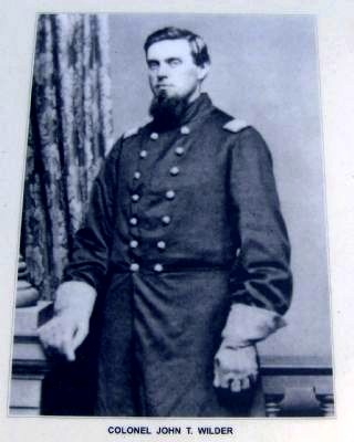
On September 11, 1863 Federal forces from Van Cleve’s Division of the 21st Army Corps of the Army of the Cumberland invaded Ringgold from the west. At the same time, Colonel John T. Wilder’s Mounted Infantry Brigade invaded from the north. A few . . . — — Map (db m12020) HM
Organized in 1837, the Chickamauga Presbyterian Church, commonly call "The Old Stone Church," was a landmark in the Ringgold area at the time of the war.
The coming of the Western and Atlantic Railroad and the construction of an impressive . . . — — Map (db m207194) HM
The Evans house was a double-pen log structure located on the corner of Guyler and Nashville Streets in Ringgold. Before the war the widow Evans took in boarders at the house to provide an income for her family. Two of these were nurses from the . . . — — Map (db m68972) HM
In late August 1863, the Federal Army of Cumberland began moving toward Georgia. On the extreme right of the Federal lines, the XX Corps, approximately 5,000 soldiers commanded by Major General Alexander M. McCook, began advancing across Lookout . . . — — Map (db m116241) HM
In late August 1863, the Federal Army of the Cumberland began moving toward Georgia. On the extreme right of the Federal lines, the XX Army Corps, commanded by Major General Alexander M. McCook began advancing across Lookout Mountain with Alpine, . . . — — Map (db m134924) HM
In late August 1863, the Federal Army of the Cumberland began moving toward Georgia. On the extreme right of the Federal lines, the XX Amy Corps, commanded by Major General Alexander M. McCook began advancing across Lookout Mountain with Alpine, . . . — — Map (db m168099) HM
In late August 1863, the Federal Army of the Cumberland began moving toward Georgia. On the extreme right of the Federal lines, the XX Army Corps, commanded by Major General Alexander M. McCook began advancing across Lookout Mountain with Alpine, . . . — — Map (db m168167) HM
Headquarters, First Division
Trion Factory, September 13, 1863 12 p.m.
Maj. W. H. Sinclair:
Wheeler's force, that left for Lafayette yesterday on my approach, returned at 2 o'clock this morning to the cross-roads, at junction of Ringgold . . . — — Map (db m168169) HM
James William Cureton was born on December 25, 1829 in North Carolina. As a young man he went to Tennessee where he married Nancy Boyd. In 1849, he moved to Dade County in Georgia with the intention of finding a good site for a water powered mill. . . . — — Map (db m167659) HM
"Cloverdale" was a successful plantation established by Colonel James Cooper Nisbet and his brother. At the start of the war, James Nisbet raised a company for the 21st Georgia Infantry Regiment and went to Virginia as a Captain. In the spring of . . . — — Map (db m167667) HM
William I. Cole was a prosperous 51 year old farmer at the time of the 1860 Federal census, living with his wife and three children. With a plantation on Squirrel Town Creek, he was one of the best known slave owners in Dade County. In addition to . . . — — Map (db m167716) HM
During the war, the Macon Iron Works were built near the Trenton spring. The company was chartered in Macon, Georgia in 1862. "Mr. J. Cowles and his associates, of Macon," James A. Nisbet wrote on October 3, 1862, "have secured a large iron estate, . . . — — Map (db m167689) HM
This mill was built in 1836 by Jake Sitton, who operated it for a number of years. The material for te building was cut on Sand Mountain by Edward Price. All the lumber was of pure pine and was transported to the site by wagon with the axles . . . — — Map (db m167679) HM
The Zachariah O'Neal House is a rectangular single-pen log structure having corner timbering, and constructed with hewn logs. At one end there is a brick chimney. There is some weathering on the north end of the structure, but there is a new roof . . . — — Map (db m167698) HM
General James Negley led his 14th Army Corps division of the Federal Army of the Cumberland into Dade County by way of White Oak Gap in early September, 1863. “My division has arrived,” he reported, “and is encamped at Brown's . . . — — Map (db m167647) HM
The Redding House is a large double-pen log structure with an open breezeway between the pens. There are stone chimneys on either end of the house. The structure is in excellent condition and has been fully restored by the owner. This was a working . . . — — Map (db m167717) HM
At the base of Lookout Mountain, in 1863, there was a crossroads community known as Bailey's Crossroads. All three of these areas had considerable action during the Chickamauga Campaign in September 1863. The first of these to be entered by the . . . — — Map (db m194484) HM
Bird's Mill was built on West Chickamauga Creek during the 1840's by Philemon Bird, a member of a prominent and wealthy Georgia family. The mill was constructed well away
from the creek on a long mill race that was dug by hand to bring the water to . . . — — Map (db m168205) HM
The first obstacle facing the Federal Army in the September 1863 invasion of Walker County was getting over Lookout Mountain. Cooper's Gap, Stevens' Gap, and Dougherty's Gap proved to be serviceable. "Ascertaining that the rebels were just . . . — — Map (db m168059) HM
Crawfish Spring was the first name given to the modern community Chickamauga, Georgia. Cherokees lived in this area before their forced removal in 1838, with their Chickamauga District courthouse located near the spring. In the 1840s an early white . . . — — Map (db m12314) HM
On September 11, the last Confederate forces withdrew around 4:30 p.m. across the creek to a stand of timber about a half mile east of the mills. Harker's federals moved into position near the mills at that time.
After placing a "strong cordon . . . — — Map (db m192509) HM
In the late morning of September 20, 1863, General Joseph Wheeler's cavalry rode north along the east side of West Chickamauga Creek to the area opposite Lee and Gordon's Mills. They arrived at that point around 3:00 p.m. Most of Wheeler's . . . — — Map (db m76189) HM
In 1863 there was a thriving farming
community along West Chickamauga
Creek in the vicinity of Birds Mill. One of the most important plantations was the
Childress Plantation. Significance of this
family was such that the road now known
as Old . . . — — Map (db m168204) HM
Following the Federal victories at Lookout Mountain and Missionary Ridge in November, 1863, the Confederate army withdrew to Dalton, Georgia. The Federal Army at Chattanooga conducted periodic patrols into Walker County to forage and for . . . — — Map (db m76188) HM
Jesse Stephens was a famer living at the base of the mountain. Although the Federal records usually misspelled his name as Stevens, the name of the gap and road are derived from him. The 1860 Federal Census shows him as a 54 year old Georgia native. . . . — — Map (db m168071) HM
On September 18, 1863, the Confederate forces began a preliminary push against Reed's Bridge and Alexander's Bridge on the extreme left of the Federal position. Colonels Minty and Wilder, stationed at these bridges, had given General William . . . — — Map (db m82787) HM
Pigeon Mountain is a rugged spur of Lookout Mountain, extending in a northeasterly direction into Walker County. The space between it and Lookout Mountain is McLemore’s Cove. During the war, wagon roads passed from east to west through the mountains . . . — — Map (db m200111) HM
Chattooga Academy served as Confederate Gen. Braxton Bragg's headquarters from September 10-17, 1863. Bragg reportedly prepared for the Battle of Chickamauga under a large oak tree in front of the building; the tree, later known as Bragg's Oak, was . . . — — Map (db m82762) HM
The Marsh House was built by Spencer Stewart Marsh about 1836. Mr. Marsh was born in Chatham County, North Carolina, on November 25, 1799, and was the son of William Marsh, a soldier in the American Revolution for whom the local William Marsh . . . — — Map (db m82761) HM
In mid-September 1863, General John M. Palmer’s division of the 21st Army Corps was assigned to the duty of guarding the fords on West Chickamauga Creek. A primary Federal objective was keeping the Confederates on the east side of the creek while . . . — — Map (db m11986) HM
The Dr. Anderson House Camp Site is located on the northwest corner of the intersection of Old Lafayette Road and Straight Gut Road, approximately one mile north of Rock Spring, Georgia.
A substantial community grew up around the Rock Spring . . . — — Map (db m168178) HM
The majority of the people who came into the area to establish Walker County were deeply religious. Soon after establishing their farms, the residents of most areas usually built a church that also served as a community and social center for the . . . — — Map (db m13238) HM
The majority of the people who established Walker County were deeply religious. Soon after establishing their farms, the residents of most areas usually built a church. In a typical example, the Rock Springs Methodist Church was established in a log . . . — — Map (db m82758) HM
Pigeon Mountain is a rugged spur of Lookout Mountain, extending in a northeasterly direction into Walker County. The space between it and Lookout Mountain is McLemore's Cove. During the war, wagon roads passed from east to west through the mountain . . . — — Map (db m82759) HM
A major objective of General Braxton Bragg's Confederate Army of Tennessee during the Chickamauga Campaign was to block the Federal Army from Chattanooga. Similarly, General William Rosecrans' Federal Army of the Cumberland made every effort to keep . . . — — Map (db m67740) HM
At the time of the Civil War the community of Rossville, Georgia consisted of no more than a half dozen buildings. The most conspicuous of these structures was a two-story log dwelling built in 1797 by John McDonald, maternal grandfather of John . . . — — Map (db m130173) HM
Mr. Xzanders Gordon McFarland of Walker County (Rossville Georgia) was a slave holder. So when the Civil War took his two oldest sons into the army, he gathered his slaves, his four teenage daughters and his stock and went to South Georgia for . . . — — Map (db m238820) HM
After the Shiloh Campaign in the spring of 1862, Confederate forces under General Braxton Bragg concentrated in the Chattanooga area. The Federal Army, under General Don Carlos Buell occupied north Alabama. Fearful of a Confederate attack, General . . . — — Map (db m82250) HM
The Nashville and Chattanooga Railroad Bridge over Running Water Creek was a vital link in the rail connection between Nashville and Chattanooga. The retreating Confederate Army destroyed it in the summer of 1863.
The pursuing Federal Army . . . — — Map (db m82253) HM