On Ring of Kerry (National Route N70), on the left when traveling east.
Chief Justice of Ireland 1961-1973
Judge of the European Court of Justice 1973-1974
President of Ireland 1974-1976
Unveiled June 5th, 1983
by
The President of Ireland
Dr. Patrick Hillery
Sculptor-Vivienne Roche
I don't . . . — — Map (db m139942) HM
On Ring of Kerry (National Route N70) at Sportsfield Road, on the left when traveling east on Ring of Kerry.
En ce moment grave de ma longue vie,
j'ai trouvé ici ce que je cherchais :
être en face de moi-même.
L'Irlande me l'a offert
de la façon la plus delicate,
la plus amicale.
(18.VI.1969) . . . — — Map (db m139881) HM
On Ring of Kerry (National Route N70) at Church Street, on the left when traveling east on Ring of Kerry.
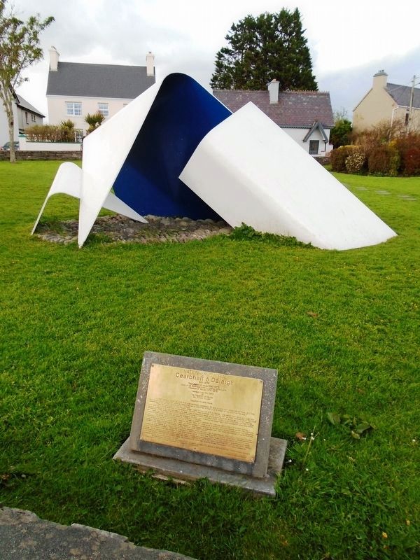
One of the 'All-Time Great' Gaelic football stars
and a member of Kerry's 'Golden Era Team'
of the 1970s and 80s. John played for Sneem Gaa club
and following retirement from Kerry,
for Bishopstown in Cork where he worked.
He . . . — — Map (db m139889) HM
On Ring of Kerry (National Route N70) at Quay Road, on the right when traveling east on Ring of Kerry.
[Chinese script not transcribed]
Go maire an Cairdeas idir Pobal na Síne agus na hÉireann go deo. Tiomnaithe d'Iar-Uachtarán na hÉireann, A Oirirceas an tUas. Cearbhall Ó Dálaigh, nach maireann, ag Comhlachas Phobal na Síne um . . . — — Map (db m139934) HM
On Ring of Kerry (National Route N70) at Sportsfield Road, on the left when traveling east on Ring of Kerry.
Gift to the people of Ireland
from the President of Israel,
Chaim Herzog,
in memory of Cearbhall Ó Dálaigh.
Wednesday 19th June, 1985
Sculptor Tamara Rikman
——————————
Ar na bhronnadh ar
mhuintir . . . — — Map (db m139887) HM
Tá sé seo ar cheann de na cathracha is mó agus is breátha in Éirinn agus is dóigh gur i gcéadta luatha d'aois Chríost, sular tháinig an Chríostaíocht go hÉirinn, a tógadh í. Ní foláir nó go raibh taoiseach nó feimeoir . . . — — Map (db m140605) HM
On Ring of Kerry (National Route N70) just north of Southview Terrace, on the left when traveling north.
Fear na scannan cara an choireáin
a chaith blianta shona inár measc.
For the man who made the movies
speak in the hearts of millions
Charlie spent many years in our
midst as a welcome and humble
guest and friend of . . . — — Map (db m140959) HM
On National Route N70 at Iveragh Terrace, on the right when traveling north on National Route N70.
This is the main entrance to the Cable
Station property. This station operated
6 cables to America, 4 cables to the U.K.
and 2 to France. Together with its sister
companies it relayed cablegrams worldwide.
The company broke the monopoly . . . — — Map (db m141068) HM
On Ring of Kerry (National Route N70) at Southview Terrace, on the left when traveling north on Ring of Kerry.
Dr. Millerick served this community with great diligence for
11 years from 1887 until his death in 1898 at the age of 33.
He is buried at Abbey Island, Derrynane in the O'Connell family plot.
Derrynane Dispensary Committee . . . — — Map (db m140949) HM
On Iveragh Terrace, on the left when traveling north.
Built in 1858, as a shooting lodge,
by J. Clemanti.
The Commercial Cable Company
purchased the lodge in 1884 for the
superintendent's residence and as
the company's first office.
The office was later enlarged by
an extension . . . — — Map (db m141081) HM
On Iveragh Terrace, on the left when traveling north. Reported missing.
Superintendent's Residence
Take a moment to read the adjacent
commemorative plaque for information
on the heritage of this house.
In addition to the Superintendent's residence the
grounds also included the Bachelor's quarters . . . — — Map (db m141086) HM
On Iveragh Terrace, on the right when traveling north.
Determined in 1892
by
Herbert Hall Turner
and
Henry Park Hollis
Royal Observatory, Greenwich
and
Prof. Clement H. McLeod
McGill . . . — — Map (db m141094) HM
On Iveragh Terrace, on the right when traveling north. Reported missing.
Erected by the Commercial Cable Company in
the 1890's to mark Waterville Cable Station's
participation in the 1892 international project with
Greenwich Observatory and McGill University,
to determine the longitude of . . . — — Map (db m141096) HM
On National Route N70, 0.1 kilometers north of Southview Terrace, on the left when traveling north.
Born
9th June 1936
Birthplace
Waterville, Co. Kerry
Parents
John O'Dwyer and Mary Galvin
Married
Mary Carmel O'Sullivan on 20th Feb 1962
Family
Four sons: John, Michael, Robert and Karl
----------------
Inter-County . . . — — Map (db m140960) HM
On Iveragh Terrace, 0.1 kilometers east of Ring of Kerry (National Route N70), on the right when traveling east. Reported missing.
This building, designed by renowned Irish architect
J.F. Fuller FSA, housed the offices of the
Commercial Cable Company from 1899 to 1964.
Worldwide telegraphs were received and transmitted
from here. Waterville was one of the . . . — — Map (db m141069) HM
On Main Street (National Road 21) at The Square, on the left when traveling north on Main Street.
His grateful fellow countrymen at home and beyond the seas have erected this monument to the memory of Rev. William Casey, for a quarter of a century prior to his death, the parish priest of this parish. He found his people struggling in the . . . — — Map (db m24739) HM
On Main Street (National Route N21) 0.1 kilometers south of the River Maigue, on the right when traveling south.
The Augustinian Friary, known as the Black Abbey, was founded in 1316 by the Earl of Kildare. It is now the Church of Ireland (Anglican) parish church and school.
The Augustinian friars first came to Dublin from England in about 1260. They were . . . — — Map (db m143072) HM
On Main Street (National Route N21) just east of Station Road (Local Route L1423), on the left when traveling east.
In grateful memory of the zeal shewn by the
people of this village in quenching a fire at the
offices of Adare Manor on the 18 April 1844
This supply of water was brought and fountain
erected by Caroline Countess of Dunraven
Lord prosper . . . — — Map (db m142967) HM
On Main Street (National Route N21) at Station Road (Local Route L1423), on the left when traveling west on Main Street.
The old town of Adare, which stood on the northern bank of the river Maigue near the castle, was destroyed during 16th century wars. Almost all of the present town was built in the 19th century.
In 1683 Thady Quin, a local landowner, leased the . . . — — Map (db m142919) HM
On Black Abbey Road (Local Route 1422) 0.1 kilometers west of Rathkeale Road (National Route N21), on the right when traveling west.
1756-1778
John Wesley, Founder of the Methodist Church visited this area on ten occasions during these years. A strong local tradition affirms that he preached under an ash tree near the ruin of the Franciscan Abbey on at least one of these . . . — — Map (db m142812) HM
On Main Street (National Route N21) just east of Station Road (Local Route L1423), on the left when traveling east.
Founded in 1230, this is the only monastery of the Trinitarian order known in Ireland. It is now Holy Trinity Abbey, Adare's Roman Catholic church.
The Trinitarian order - or the Order of the Redemption of Captives - was founded in France at the . . . — — Map (db m142969) HM
On Main Street (National Route N21) close to Station Road (Local Route L1423), on the left when traveling west.
This small pool, formed by a tributary of the river Maigue, was the traditional place for the women of Adare to wash their family clothes. It was also used as a watering place for animals.
[Illustration captions, counterclockwise from top left, . . . — — Map (db m142922) HM
On South Quay (National Route N21) just east of Lower Knockane Road, on the left when traveling east.
CAPT. DONAL SHEEHAN, Monagae, drowned at Ballykissane Pier, when going to meet the German gunship the "Aud" 20/4/1916
CAPT. CON COLBERT, Castlemahon, fought in the GPO during Easter week, executed by firing squad 7/5/1916
LT. DANIEL . . . — — Map (db m143114) HM
On Main Street (Munster Route R639) at Boherclogh Street (Munster Route R639), on the right when traveling west on Main Street.
An Scairdeán
Saoránaigh Chaisil a thóg an scairdeán seo mar aitheantas ar ról an Déin Tomás Ó Coinneáin, S.P. chun an bóther iarainn a thabhairt go Caiseal. Nochtaíodh é ar 19ú Nollaig 1904, an lá a thaistil an chéad traein ó . . . — — Map (db m137018) HM
Carraig Phádraig
Ba í Carraig Phádraig, ceann de na láithreacha is stairiúla in Éirinn, suí rithe na Mumhan ón 4ú haois go dtí 1101 an uair a bronnadh ar an Eaglais í. Is iad seo na séadchomharthaí is tábhachtaí anseo:
Séipéal . . . — — Map (db m78627) HM
On Ladyswell Street (Munster Route R639) at The Kiln/Moor Lane Roundabout (Munster Route R660), on the right when traveling north on Ladyswell Street.
Falla an Ghorta Mhóir/An tArdán
Thóg Coimisinéirí Chaisil Falla an Ghorta Mhóir mar chuid d'obair fheabhasacháin an bhaile tar éis dá n-oifigeach dlí, Micheál Ó Dubhchonna, cúiteamh airgid a fháil ó thiarna talún sna blianta i . . . — — Map (db m136977) HM
On The Kiln (Munster Route R660) at Ladysmith Street (Munster Route R639), on the right when traveling north on The Kiln.
Tobar Mhuire
Ainmníodh Tobar Mhuire in onóir na Maighdine Muire agus b'ionad oilithreachta é ag muintir na háite go dtí deireadh an 19ú haois. Ba í Sráid Thobar Mhuire ionad Aonaigh Chaisil ar feadh breis is 1500 bliain. Bhíodh dhá . . . — — Map (db m137015) HM
The ruined castle before you was first built by the Norman followers of Theobald Butler as a 2 storey hall-keep in the 13th/14th c. One Thomas de Cantwell paid tax for the land of the manor of Dromineer in 1299. In the late 14th c. the land . . . — — Map (db m143104) HM
On the lakefront access road, 0.1 kilometers west of Munster Route R495, on the right when traveling west.
Dromineer in the 19th century-especially before the coming of the railway to Nenagh in 1863-was in a real sense the port of northwest Tipperary. Dromineer was the transit point for much of the commercial traffic for the area, including the canal . . . — — Map (db m143098) HM
133 entries matched your criteria. Entries 101 through 133 are listed above. ⊲ Previous 100