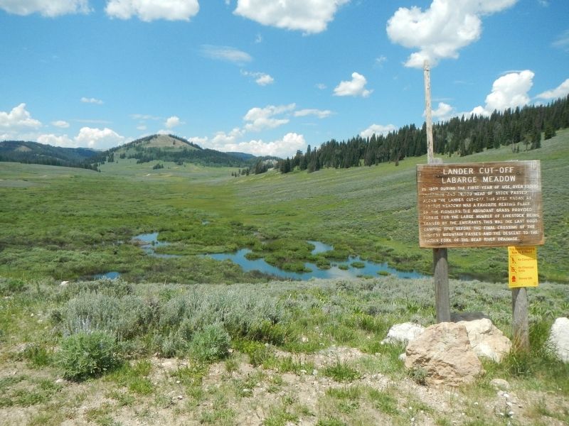
In 1859 during the first year of use, over 13,000 emigrants and 19,000 head of stock passed along the Lander Cut-Off. This area known as LaBarge Meadows was a favorite resting place of the pioneers. The abundant grass provided forage for the large . . . — — Map (db m179895) HM
At this point the pioneers began their ascent of the mountains, having traveled 106 miles since leaving the main road. The graves nearby are those of emigrants left behind as a result of hardships, accidents and disease. Death was a frequent visitor . . . — — Map (db m180088) HM
In about 1890 an immigrant wagon tipped over at this crossing, A small girl was drowned and was buried in this vicinity. The exact location of garage is unknown. — — Map (db m179902) HM
The Lander Road or "Trail" crosses the New Fork River just beyond this sign. Here, the river was shallow enough to allow emigrant wagons to ford the river without aid of a ferry. The good water, livestock feed, and firewood made this a popular . . . — — Map (db m180093) HM
The water runoff from nearby mountains changes seasonally and from year to year. Emigrants used a variety of methods for crossing, depending on how much water flowed in the New Fork River.
Fording the New Fork: Low Water Crossing . . . — — Map (db m96871) HM
The Lander Cut-Off of the Oregon Trail was constructed in 1858. It was the first federally funded road west of the Mississippi River. After leaving the original Oregon Trail near South Pass, the Lander Cut-Off crossed this mountainous region and . . . — — Map (db m180089) HM
Livestock outnumbered emigrants five to one on the Lander Trail. A typical emigrant wagon needed four mules or 4-6 oxen to pull a wagon with up to 2,000 pounds of supplies. Emigrants also brought riding horses, milk cows, beef cattle, and even . . . — — Map (db m100366) HM
This site is a crossing of the Lander Cut-off, the northern fork of the Oregon Trail. Originally called the Fort Kearney-South Pass-Honey Lake Wagon Road when it opened in 1858, it was the first federally-funded road project west of the Mississippi . . . — — Map (db m47092) HM
Route of Lander cut-off first government financed road in Wyoming. Officially called Ft. Kearney, South Pass and Honey Lake Road. Built in 1858 from Rocky Ridge to Ft. Hall to provide shorter route for emigrants. — — Map (db m47093) HM
To
Narcissa Prentiss Whitman
and
Eliza Hart Spalding
Missionaries
First white women in Wyoming
and
First women over Oregon Trail
1836
July 6 to July 18 was spent at
“Green River Rendezvous” . . . — — Map (db m80518) HM
This marks a fork in the trail, right to Oregon, left to Utah and California.
1812, Robert Stuart and eastbound Astorians used South Pass gateway.
1824, Eleven westbound Ashley-Henry men led by Jedediah Smith and Thomas Fitzpatrick.
. . . — — Map (db m67035) HM
This point on the trail is called the Parting-of-the-Ways. The trail to the right is the Sublette or Greenwood Cutoff and to the left is the main route of the Oregon, Mormon, and California Trails. The Sublette Cutoff was opened in 1844 because it . . . — — Map (db m96684) HM
Trail ruts at this site were mistakenly identified as the Parting-of-the-Ways where emigrant parties separated on their journeys to Oregon, California, or Utah.
The actual Parting-of-the-Ways is approximately 10 miles west of this spot. . . . — — Map (db m237433) HM
In July 1844 the California bound Stevens-Townsend-Murphy wagon train, guided by Isaac Hitchcock and 81-year old Caleb Greenwood, passed this point and continued nine and one half miles southwest from here, to a place destined to become prominent . . . — — Map (db m67036) HM
Mr. John F. Patterson, known as the Founder of Pinedale, proposed establishing a town at this location. He offered to build and stock a general store if local ranchers Charles A. Petersen and Mr. Robert O. Graham each donated five acres for the town . . . — — Map (db m90929) HM
Graves were an all-to-frequent reminder of the dangers of overland travel. Most emigrant journals record death, burial, or passing graves during the day's travel. Most burials along the trail were hasty affairs.
The official Company Journal of . . . — — Map (db m67045) HM
Death on the trail did not allow for the fineries of the funerals back home. Emigrants made do with materials available. Black would adorn the clothes of mourners, and care would be taken to provide the best funeral possible. The most travelers . . . — — Map (db m67044) HM
Just a few miles from where you're standing, the emigrants would come to the first of several trail "splits" that would take them to a crossing on the Green River where they would camp for the evening.
Even with South Pass behind them, Oregon . . . — — Map (db m67043) HM
Crossing rivers was the most dangerous activity emigrants faced on their journey west. By the time weary pioneers enroute (sic) to Oregon, California, or Utah reached the east bank of the Green River, they had been on the trail for several months. . . . — — Map (db m90015) HM
Death was a constant companion for emigrants headed west. It is estimated that 10,000 to 30,000 people died and were buried along the trails between 1843 and 1869.
Cholera and other diseases were the most common cause of death. People didn't . . . — — Map (db m67046) HM
Relations between emigrants using the trails and the Indians were inconsistent during the migration period. While hostile acts and violent confrontation did occur, they have been overemphasized in trail history. During the early migration period of . . . — — Map (db m67049) HM
If you look down the river about 250 yards on the right side - there's a wooden ferry. The ferry you see was built by Forrest Cramer of Pinedale, Wyoming in 1997 of the 150th anniversary celebrations of the Mormon Pioneer National Historic Trail. . . . — — Map (db m88481) HM
This spot where the old Oregon and Mormon Trails cross the Little Sandy River (or Creek) was a popular camping and resting place for travelers headed to Oregon, California and Utah. Indeed, this site is one of the most significant landmarks on the . . . — — Map (db m96697) HM
On Monday evening, June 28, 1847, Brigham Young and the Mormon pioneers met James Bridger and party near this place. Both companies encamped here over night and conferred at length regarding the route and the possibility of establishing and . . . — — Map (db m47138) HM
For the hundreds of people heading west, life was one day at a time. The travelers had settled into the monotonous routine of life on the trail - up before dawn, an early breakfast, hitch up the stock, and begin the day's journey.
Upon safely . . . — — Map (db m90035) HM
The emigration of Mormon (Church of Jesus Christ of Latter-dat Saints) converts to Utah is a fascinating chapter of the overall American westering experience of the 19th century. In search of religious freedom and an end to persecution, Mormon . . . — — Map (db m88477) HM
On the horizon about 25 miles to the south is Pilot Butte. An important landmark, Pilot Butte served as a guide post separating South Pass trails from the more southerly Overland Trail that crossed southern Wyoming. Oddly enough, Pilot Butte was . . . — — Map (db m67047) HM
Welcome to the Pilot Butte Emigrant Trails Interpretive Site. The purpose of the site is to help you gain a sense of what life was like for the 400,000 emigrants who left their homes to seek a new life in the West. They were seeking wealth, . . . — — Map (db m67042) HM
One of only three significant engagements of the Utah War, the incident at Simpson's Hollow played a key role in the conflict. The Utah War (1857-1858) was the result of a lack of communication between the U.S. Government and the Utah Territory . . . — — Map (db m67038) HM
Long before the Oregon/California westward migration, animals instinctively stopped at the Big Sandy River during their migration process. With South Pass just 35 miles east, the river was also a natural East-West pathway for man. The pathway, in . . . — — Map (db m47136) HM
This site of the Lombard Ferry was one of the most used crossings on the Green River, lasting from about 1843 into the early 1900s. First established by mountain men, it was operated by Mormons in the 1850s during the peak years of the westward . . . — — Map (db m88473) HM
In September 1868 the Union Pacific Railroad established the town of Bryan, named for Lt. Francis Theodore Bryan, a surveyor. The town was located eleven miles west of Green River and north of this location. Passing beyond the settlement at Green . . . — — Map (db m67759) HM
To All Pioneers
Who Passed
This Way
To Win And Hold
The West
Trail Crossed
30 Miles North
This Point
Erected By
People Of
Green River 1931 — — Map (db m67775) HM
For the first 100 years of its history, Green River's population fluctuated between 2,000 and 4,000 people. Townspeople lived north of the Green River, staggered on both the north and south sides of the railroad tracks. In the 1970s, an increase in . . . — — Map (db m90068) HM
Center panel:
From this point you can see Linwood Bay of the Flaming Gorge Reservoir. Beneath the surface of the reservoir at the far western end, lies the site of the town of Linwood. When Flaming Gorge Dam was built in the early . . . — — Map (db m90096) HM
After the Civil War, the Union Pacific laid track westward, bringing commerce to the wilderness. Establishment of the transcontinental railroad and the communities which sprung up around the railroads helped settle the Territory of Wyoming. . . . — — Map (db m73958) HM
Buried under the streets of Rock Springs are seams of coal. In 1850 Howard Stansbury noted that coal could be found near the present town. When, in 1868, the Union Pacific Railroad built through the area, the large commercial mines opened. Number 1 . . . — — Map (db m67812) HM
The people who moved into Superior were from diverse ethnic backgrounds. They came from Austria, Slovenia, England, Wales, Scotland, Germany, Italy, Japan and Greece. Other nationalities loved (sic) and worked in various Superior communities . . . — — Map (db m92210) HM
This monument is dedicated to the miners who worked here and especially to those who lost their lives. It is also a monument to the living -- those who ave remained and exemplify the men and women whose independent character created this community. . . . — — Map (db m92235) HM
This map shows the location of the Union Pacific coal mines and coal camps built in the years between 1906 and 1910. The town of South Superior is purposefully left off this map. It was not owned by Union Pacific Coal Company and in this time . . . — — Map (db m92212) HM
In 1889, five Mormon families pioneered Jackson Hole making the trip of 28 miles in 14 days over Teton Pass. Their leader was Elijah N. Wilson, known among the people as "Uncle Nick" - famous Indian scout and Pony Express rider. They found 18 single . . . — — Map (db m90977) HM
Store owner Bill Menor, prone to swearing and a surly attitude, ran this general store in the early 1900s. Menor and is brother, Holiday, painted this building with whitewash from Holiday’s lime-kiln. Referring to Bill, Holiday was known to say: . . . — — Map (db m88073) HM
Homesteaders, who settled here near the turn of the 19-century, clustered their farms to share labor and community. As you walk imagine 33 homesteads surrounding a church and school. Structures from six homesteads remain here. Settlement . . . — — Map (db m88280) HM
J. Pierce Cunningham settled here in Jackson Hole in the 1880s despite the hardships of winter. He initially opposed the expansion of Grand Teton National Park but later became an advocate. He teamed up with neighbor Josiah “Si” Ferrin . . . — — Map (db m88087) HM
Bill Menor cured game and livestock in this smokehouse to keep the meat from spoiling. Before smoking, he salted the meat to preserve it. — — Map (db m88079) HM
Bill Menor safeguarded food here from animals and the elements. Under this storehouse Menor preserved root crops cooled by ice he cut during the winter. — — Map (db m88078) HM
View Bill Menor’s original 1892 homestead along the Snake River. Follow the loop trail and learn about the early days of Jackson Hole. In 1969, the National Register of Historic Places designated this place an historic district. < Sidebar . . . — — Map (db m88071) HM
In Memory of
Dick Turpin
Soldier, Scout and Pioneer
Settled here 1887
Erected by the Trustees
Robert E. Miller
F. Buchernroth
C.R. Van Vleck
Wm. L. Simpson — — Map (db m97630) HM
In 1889, Uncle Nick joined his older brother Sylvester who brought the first Mormon settlers over Teton Pass into Jackson Hole. It took 14 days for the band to travel 90 miles from St. Anthony, Idaho to Wilson, Wyoming, the town which bears his . . . — — Map (db m62278) HM
Nineteenth Century railroads were dependent upon coal for fuel. The vast coal reserves of southern Wyoming helped determine the route of the transcontinental Union Pacific Railroad and were the basis for Wyoming's first energy boom. . . . — — Map (db m36537) HM
Nothing remains today as a reminder that Bear River City was one of the notorious "end-of-track" towns along the original Union Pacific transcontinental railroad line. Initially called Gilmer, the town was first settled by lumberjacks who arrived . . . — — Map (db m225755) HM
The Bear River Watershed spreads across 7,500 square miles of mountain and valley lands that encompass portions of Idaho, Utah, and Wyoming. Bear River is the main tributary to the Great Salt Lake and is the longest stream in the western hemisphere . . . — — Map (db m67972) HM
Evanston was established by the Union Pacific Railroad Company late in 1868. In the first county election, September 6, 1870, Evanston was chosen county seat. Union Pacific Railroad shops moved here in the fall of 1871. Timber and sawmill operations . . . — — Map (db m67738) HM
In February 1873 a branch of the Church of Jesus Christ of Latter-Day Saints was organized in Evanston by President William Budge, of Bear Lake Valley, Idaho. On May 23, 1873 William G. Burton was ordained bishop. On June 24, 1890 this ward was . . . — — Map (db m36400) HM
Several plaques are located at this kiosk
Hilliard City and Piedmont
Early settlers began to arrive on "Hilliard Flats" in 1860 to ranch and grow crops. Long, cold winters and short growing seasons made it difficult to . . . — — Map (db m90438) HM
The first settler in the Hilliard area was John Myers who arrived in the middle to late 1850s. He worked at Fort Bridger in 1857, and in 1860 made his home on the Bear River where the Salt Lake Trail (California/Mormon Trail) crossed the river, a . . . — — Map (db m90437) HM
The Oregon and California Trails came into Uinta County from South Pass, whereas the Overland Trail came through Bridger Pass. In 1845, more than 3,000 emigrant were on the Oregon Trail seeking adventure, fortune or religious freedom.
The . . . — — Map (db m90113) HM
Erected
by the members of
the Woodruff Stake
of the Church of
Jesus Christ of
Latter-Day Saints
in honor of the
Pioneers who
passed this spot
July 12, 1847
under the leadership
of Brigham Young . . . — — Map (db m90124) HM
"At three o'clock p.m. we crossed Muddy Creek, a beautiful clear stream of water with a pebbly bottom, and camped on the west side after traveling 3 miles during the day ... we had a pretty campground... The brethren sang hymns for the President; . . . — — Map (db m36566) HM
1804-1881
Famous mountain man, trader and scout Donated by the Fort Bridger Historical Association Dedicated 8-8-08
Artist David A. Clark — — Map (db m13650) HM
The Muddy Creek Camp, which was northwest of this marker and on the west side of the Muddy Creek was used by Brigham Young's first group of Mormon pioneers who arrived here on July 9, 1847. Thomas Bullock reported that the brethren sang . . . — — Map (db m36573) HM
The fort was established about 1842 by Jim Bridger discoverer of Great Salt Lake; notable pioneer, trapper, fur trader, scout and guide. Bridger was born at Richmond, Virginia, March 17, 1804 and died at Westport, Missouri, July 17, 1881. His . . . — — Map (db m36596) HM
From the late 1840s through the 1860s, an exodus of more than 70,000 Mormons passed by here on their way to their "New Zion" in Utah. Starting from Nauvoo, Illinois in February 1846, the first group of at least 13,000 Mormons crossed into Iowa to . . . — — Map (db m90583) HM
Four panels are located at the kiosk
Town of Piedmont
Located west of the kilns, the town of Piedmont started out as a logging camp supplying ties for the approaching Union Pacific Railroad in the 1860s. It also served as . . . — — Map (db m90444) HM
Erected by
The Members of
the
Woodruff Stake
in Honor of
The Mormon Pioneers
Who passed this point
Wednesday July 7, 1847
and in subsequent years — — Map (db m36620) HM
Established in November, 1853, by Captain John Nebeker and Captain Isaac Bullock who located here with a number of Latter Day Saints. This was the first place in Wyoming where land was irrigated. The site was given to Wyoming by Anton Hansen . . . — — Map (db m174178) HM
To all Pioneers
and in Memory of
C.H. "Dad" Worland
for whom the town was named. He erected the stage station on the old Bridger Trail about 100 yards north of here.
That spot was the original town site established in 1904. The town . . . — — Map (db m97830) HM
Dedicated to those who persevered and conquered
CITY of WORLAND
Charles H. “Dad” Worland in 1900 dug his underground stage stop here on the old Bridger Trail. From Dad’s dugout grew the City of Worland drawing pioneer men and . . . — — Map (db m97861) HM
The frontier settlement of Worland was originally located near the mouth of Fifteen Mile Creek on the west bank of the Big Horn River. It grew around a stage coach station established in 1900 by Charles H. “Dad” Worland on the old . . . — — Map (db m97829) HM
The Black Hills, named after the dark green carpets of pines that cover the hills, are a geological wonder. Covering some 125 miles north to south and 65 miles east to west, the Hills rise 3,000 to 4,000 feet above the red valley floor. Below you . . . — — Map (db m98171) HM
The deserted site of Field City or Tubb Town offers silent testimony to the boom and bust fate of many western towns.
In the spring of 1889 Deloss Tubbs, a businessman from Custer, Dakota Territory, laid out Field City around his store on the . . . — — Map (db m34872) HM
274 entries matched your criteria. Entries 201 through 274 are listed above. ⊲ Previous 100