S.W. corner of site chosen by General Grenville Dodge in 1867 for the division point of the U.P.R.R. and for the location of Cheyenne City. The original 4 sq miles were laid at an angle to give "all houses maximum sunshine throughout the year." This . . . — — Map (db m68053) HM
There are six plaques on this rather large monument. Prehistoric Cheyenne
Those First to Life Here
There is evidence of prehistoric man living in Wyoming more than 12,000 years ago before present (YBP). These early . . . — — Map (db m96408) HM
This stone marks that road of romance and adventure traveled by trappers, traders and troops to Fort Laramie, the most historic spot in the west.
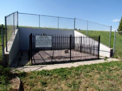
1867 - 1887 — — Map (db m95230) HM
Side A By 1868 the community boasted 3,000 to 4,000 residents, plus business, schools, churches and newspapers. The UP's stone roundhouse was the first permanent structure (non-wood) built in town. The City's phenomenal growth produced its . . . — — Map (db m47182) HM
The scene depicts a typical meeting of the Indian and the Mountain Man on the open plains of Wyoming during the time of western discovery and exploration in the early 1800’s.
At such meeting the offering of friendship would take place. The . . . — — Map (db m94225) HM
Long before the railroad, airplane, and automobile; the desire to develop the West brought explores, mountain men, fur trappers and a few brave settlers into Wyoming. Later this would be followed by miners, farmers and ranchers, and hundreds of . . . — — Map (db m95197) HM
First Mormons of record in the valley were 40 emigrants, miners from England, employed in 1858 by F.W. Lander to work on the Lander Cut-Off of the Pacific Wagon Road. By 1870 Church cattle were summer pastured in the valley. In 1879 the Church . . . — — Map (db m90526) HM
Dry Creek, later called Mt. Pleasant, was settled in 1886. The first public building erected in this area, 1891, was a log schoolhouse also used as a church. Students furnished their own desks and stools. George Hardman, teacher. Osmond Ward, . . . — — Map (db m90525) HM
Cokeville is situated at the confluence of the Bear River and Smiths Fork valleys. Between 1812 ad 1865, these valleys were the domain of American Indians, fur trappers and traders; during the 1830s and 1840s, they became a well traveled pathway of . . . — — Map (db m90480) HM
Many camping areas were used by the pioneers on their way west after making the Ham's Fork Crossing. This "Emigrant Springs" camping area became a favorite spot for the emigrants to spend the night. Abundant fire wood, livestock feed and good water . . . — — Map (db m179621) HM
Oldest surviving house in Star Valley is this two room dwelling built in 1889 by Anna Eliza Baker and her 12 year old daughter May. The logs are hand-hewn on four sides and dovetailed at the corners. It was the first home in this area to have a . . . — — Map (db m90565) HM
Within this fence lie the graves of five or six pioneers who lost their lives while traveling to the gold fields of California and the fertile Willamette Valley of Oregon.
Alfred Corum and his brothers John, Herod, and Simeon left Cooper County, . . . — — Map (db m179620) HM
In April, 1852, four brothers, Wesley, Samuel, James and Steven Hill, together with their families, 62 persons in all, left Paris, Monroe County, Missouri, for California.
Their were two deaths along the Platte River and here on the Hamsfork . . . — — Map (db m179619) HM
He little knew that when he cut his name, or had it cut, in this stone, that it would be engraved in the annals of the West deeper than that of any other man. As one of the world's outstanding explorers he guided emigrants, railroads and army in the . . . — — Map (db m36660) HM
To the Shoshone Indian, this river was the Seeds-Kee-Dee Agie (Prairie Chicken River). On Sept. 16 1811, the Astorians near its headwaters termed it the Spanish River. To the Spaniards, far to the south, it was the Rio Verde (Green River). Jedediah . . . — — Map (db m36659) HM
Thousands of pioneers journeyed over 1,000 miles to reach this point. Illness and death were common. Everywhere along the trail people died and were buried.
It is estimated that one out of ten emigrants who started on the trail died before . . . — — Map (db m95503) HM
The Legend of Devil’s Gate
American Indian legend says a powerful evil spirit in the form of a tremendous beast with enormous tusks ravaged the Sweetwater Valley, preventing the Indians from hunting and camping. A holy man told the . . . — — Map (db m95488) HM
This isolated mass of granite sprawls over 27 acres next to the meandering Sweetwater River. More than a mile in circumference, Independence Rock is 700 feet wide and 1,900 feet long. Its highest point, 136 feet above the rolling prairie, stands as . . . — — Map (db m153264) HM
Two miles to the northwest nestled at the foot of the Sweetwater Rocks, lies Martin's Cove. Here Captain Edward Martin's exhausted company of Mormon handcart emigrants sought shelter from a severe early winter storm in 1856. The Martin Company, low . . . — — Map (db m95501) HM
Survivors of Captain Edward Martin's Handcart Company of Mormon emigrants from England to Utah were rescued here in perishing condition about Nov. 12, 1856. Delayed in starting and hampered by inferior carts it was overtaken by an early winter. . . . — — Map (db m95487) HM
It is believed that William Sublette named this landmark Independence Rock during an Independence Day celebration here on July 4, 1830. Sublette, a fur trapper and mountain man, had stopped at the site while leading an expedition to the Wind River . . . — — Map (db m154136) HM
In front of you is the Sun Ranch, one of the first large open range ranches in Wyoming. The original ranch building, which today makes up part of the Mormon Handcart Visitor Center, was constructed in 1872.
Tom de Beau Soleil (a French Canadian . . . — — Map (db m95502) HM
The Oregon Trail passed over the ridge to the east of Devil's Gate. Good grass, water and the shelter of the hills made this a popular campsite.
Explorer Brevet-Captain John C. Fremont, 1842:
"In about three miles, we reached the . . . — — Map (db m95504) HM
In 1852 an estimated 50,000 pioneers passed Independence Rock on their way west. Among this number was the family of 21-year-old Ezra Meeker, recently of Eddyville, Iowa, but natives of Indiana. Meeker, his wife Eliza, and their infant son, arrived . . . — — Map (db m95546) HM
Large numbers of cattle populated this country prior to the devastating storms of the 1880’s. Sheep were far more profitable than cattle and sheep herds began to multiply. However, the terrible winter of 1919 and predators took their toll on . . . — — Map (db m86920) HM
Daunting to some, invigorating to others, the view from here gave emigrants a sense of the dramatic beauty and grand scale of the West. Many pioneers, tired after having climbed four hundred feet above Willow Springs, were humbled by this panorama. . . . — — Map (db m95598) HM
"Sunday Jun 15. Traveled 25 miles, about one mile from the springs is Prospect Hill. It is a delightful view, and here you can see the range of Sweet water mountains..." Excerpt from the 1851 journal of Amelia Hadley in Covered Wagon . . . — — Map (db m95597) HM
The eighteenth century brought competition among Spain, France, England and the fledgling Unites States for control of North America. Domain over the continent's rivers, seaports, forests, rich soils, and wildlife resources was key to the growth of . . . — — Map (db m95596) HM
Many travelers along the Oregon, California, and Mormon Pioneer trails relied on maps and reports made by explorers or guides who knew the way. William Clayton provided early emigrants with a detailed written record of his travels. As a member of . . . — — Map (db m91950) HM
Many travelers along the Oregon, California, and Mormon Pioneer trail relied on maps and reports made by explorers or guides who knew the way. William Clayton provided early emigrants with a detailed written record of his travels. As a member of . . . — — Map (db m95600) HM
Bessemer (1888-1892) was one of many small towns that grew quickly in late nineteenth century Wyoming. Early explorers and traders had discovered crude oil seeping to the surface of the ground in this area. One nearby oil spring drew the attention . . . — — Map (db m91990) HM
In this location wagons, carts, livestock, and emigrants forded the North Platte River during organized migrations through the Rocky Mountain West. Congressional prodding to occupy the Oregon Territory in the early 1840s, and the lure of fertile, . . . — — Map (db m91971) HM
Oregon Trail approximately four miles north, on bend of North Platte visible to the north. Robert Stuart in 1812 erected the first white man's cabin in Wyoming. — — Map (db m164363) HM
On April 9, 1889, application was made to have the town of Casper incorporated. John Merritt made the application in Rawlins, Wyoming since Casper was in Carbon County at that time. On July 8, 1889, Casper was incorporated and George Mitchell was . . . — — Map (db m164529) HM
middle panel:
Shaped by History
Salt Creek oil brought prosperity to Casper, in addition to people and industry. Despite the closure of Casper refineries as well as reduced output of Salt Creek oil in recent years, oil history . . . — — Map (db m92055) HM
The city of Casper, established near the site of old Fort Casper, formerly Plate Bridge Station, was named in honor of Lieut. Casper Collins, who lost his life in an Indian battle there on July 26, 1865. The fort was one of the small army posts . . . — — Map (db m86899) HM
Eadsville, a mining ghost town, is situated 12 miles due south of Casper on top of Casper Mountain. It was founded by Charles W. Eads in 1891 after he had staked a 600’ x 1,500’ mining claim around a large spring. Word had spread that large deposits . . . — — Map (db m164530) HM
This larger-than-life sculpture, “The Pony Express”, was conceived and created by the heart and hands of Avard Tennyson Fairbanks (1897 – 1987). Born into an artistic family in Provo, Utah, Avard Fairbanks showed childhood talent . . . — — Map (db m86900) HM
Originally located 3 blocks south of here, this monument was moved to this location in 1952. In an effort to rectify inaccurate information presented on the monument, the following corrections are provided. Oregon TrailThe 1849 date presented . . . — — Map (db m88148) HM
From 1840 to 1869, over 350,000 emigrants traveled past this area on the Oregon/California /Mormon Trails. The promise of free land, sudden riches, or religious freedom caused these pioneers to endure great hardships. Thousands of persons died in . . . — — Map (db m164516) HM
Pioneer Monument Erected on this site of the Old Oregon Trail in memory of the pioneers who blazed the way. Built by Natrona County Pioneer Association 1849 1911
Fort Casper ---------- U. S. Military Post Established about 1864 by . . . — — Map (db m86897) HM
Brigham Young led the first group of Mormons west from winter quarters in Nebraska in 1847, finally settling in the Salt Lake Valley. When these pioneers crossed the river here, they left nine men to operate a ferry. This ferry served fellow Mormons . . . — — Map (db m164517) HM
From the late 1840s through the 1860s, an exodus of more than 70,000 Mormons passed by here on their way to their “New Zion” in Utah. Starting from Nauvoo, Illinois in February 1846, the first group of at least 13,000 Mormons crossed . . . — — Map (db m91708) HM
center panel:
In the early 1900s, hopeful oil workers flooded Salt Creek - especially "boomers" from "gone bust" oilfields in other states. Many companies built camps next to wells to house employees. As companies changed hands and shifted . . . — — Map (db m91659) HM
Many emigrant pioneers passed through this gap, or opening, in Emigrant Ridge between the 1840’s and the 1880’s as they traveled the Oregon-Mormon Trail by oxen-drawn wagons, on horseback, or on foot. The trail generally followed the North Platte . . . — — Map (db m92013) HM
In 1919 the Mills Construction Company purchased a major portion of this area to mine sand and gravel from the floor plain of the North Platte River. This material was hauled by horse and wagon to the Midwest refinery (now Amoco) to build roads and . . . — — Map (db m92010) HM
This Redwood Water Tank was built by the Wyoming Central Railway in 1886. It was first filled by a windmill, then by other types of pumps. It stored water for the steam engines that pulled the trains. It is one of only six remaining in the nation. . . . — — Map (db m41961) HM
The Lusk House is one of the oldest buildings and was the first brick home built in Lusk. Founder of the town, Frank S. Lusk, built the home in 1886 for his mother, Cornelia Lusk, and her mother, Sarah Stillman. The Lusk family founded and helped . . . — — Map (db m242196) HM
In the early 1900s, when homesteaders flocked to eastern Wyoming where agriculture opportunities seemed very promising, the Christian Church of Dayton, Ohio organized a religious agricultural colony and college fourteen miles west of Lusk and named . . . — — Map (db m98302) HM
On September 10th 1880, Victor Arland and John F. Corbett set up the first mercantile establishment in the Big Horn Basin on the Indian Trace that follows Trail Creek. Looking to the cattlemen for business, they moved to Cottonwood Creek in 1883, . . . — — Map (db m91138) HM
Off in the distance in front of you, a large red butte lies against a much larger mountain, Rattlesnake Mountain. Flowing down the valley is Trail Creek, named for the ancient Indian trail that crosses the Shoshone River at the Indian ford in the . . . — — Map (db m87571) HM
Cedar Mountain, the mountain in front of you to the left of the canyon, was known to the Crow Indians as “the mountain of spirits.” Early settlers told of finding Indian tree burials on its northeast slope. Unfortunately, those sites . . . — — Map (db m87566) HM
John Colter, veteran of the Lewis and Clark Expedition, notably self-sufficient mountain man and indefatigable explorer, was the first white man known to have reconnoitered this locale. In 1807, possibly traveling alone but probably escorted . . . — — Map (db m86150) HM
Looking west is the Shoshone Canyon, named for the Shoshoni Indians, who hunted in the region. However, most of the Big Horn Basin had been Crow territory until the Fort Laramie Treaty of 1868. West of the canyon, the north and the south forks of . . . — — Map (db m87558) HM
The rocky ridge you are now crossing marks the southern edge of Lee Street, one of the original roads of Cody City. Wagon ruts, phone wires and rock cairn lot markers have been found along its path. In memory of Jerry Housel and Mary Elaine Housel . . . — — Map (db m87580) HM
Buffalo Bill Cody and some business partners established the Shoshone Irrigation Co. in 1894. Work began on the Cody Canal to bring water for crop irrigation from the South Fork of the Shoshone River, around the south side of Cedar Mountain. The . . . — — Map (db m87556) HM
The pioneer stagecoach drivers of the Old West were as fiercely independent as any men the country has ever seen. They were men of whang-leather toughness, who were accustomed to the harshness of frontier life. They never failed to laugh in . . . — — Map (db m87199) HM
Here on the prairie there are still visible remnants of several old wagon trails dating back to Cody City in the late 1800’s. The first buildings of Cody City were constructed on the nearby plain to the west, although the town was supposed to be . . . — — Map (db m87586) HM
A few miles up Meeteetse Creek from here, stood one of the toughest settlements of Wyoming’s frontier history. The town was founded in the spring of 1884 by Victor Arland, a French businessman, and John Corbett, a buffalo hunter. From 1880 . . . — — Map (db m87608) HM
This valley has sustained life for thousands of years. Early Native Americans were drawn here to hunt buffalo, elk, deer, moose, sheep and bear. It has always been considered a unique place. The establishment of the nation’s first park and . . . — — Map (db m89027) HM
The log cabin is Norris Soldier Station, a U.S. Army outpost when cavalry had the responsibility for patrolling the park. When the army first came to Yellowstone in 1886, the Norris basin was patrolled by on non-commissioned officer and two or . . . — — Map (db m188670) HM
Yellowstone National Park Chapel, erected 1913 at the suggestion of Honorable John W. Meldrum, first National Park U.S. Commissioner, and endorsed by Bishop William F. Nichols, Bishop Nathaniel S. Thomas, Bishop James J. Keane,
Brigadier General . . . — — Map (db m123362) HM
By wagon, encampments in the Guernsey area, are a day's trek from Fort Laramie. Emigrants had three choices of camp sites in the Guernsey area: Register Cliff, Warm Springs or Cold Springs, the farthest encampment.
Lieutenant John C. Fremont's . . . — — Map (db m85773) HM
Called Bitter Cottonwood Creek because of the groves of cottonwood trees growing there, this location was a welcome relief for emigrant pioneers as they traveled along the relatively treeless road to the west in the 1840s, 50s, & 60s. Many pioneer . . . — — Map (db m147855) HM
The sight centers on the headquarters buildings of the Guernsey-Frederick Ranch. That these building stand almost in the shadow of Register Cliff is symbolic of the valley’s heritage. Here, history emphasizes the Oregon Trail; such other epochs as . . . — — Map (db m86944) HM
Platted and established by the Lincoln Land Company of the Chicago, Burlington and Quincy Railroad, Guernsey garners its name from Charles A. Guernsey, noted legislator, rancher, and investor in early Wyoming.
The historic Guernsey area . . . — — Map (db m79807) HM
The historic Oregon Trail descends from the benchlands across the valley to the river bottom below. Brigham Young’s 1847 Company of Mormon Pioneers crossed the south side of the North Platte River near Fort Laramie to follow the Oregon Trail past . . . — — Map (db m164746) HM
Spotted through the right-hand sight is Mexican Hill. At Mexican Hill the covered wagon emigrants, having turned into the fort on the Laramie River for information, supplies or repairs, cut over the intervening ridge to regain the Platte River . . . — — Map (db m86931) HM
Wagon wheels cut solid rock, carving a memorial to Empire Builders. what manner of men and beasts impelled conveyances weighting on those griding wheels? Look! A line of shadows crossing boundless wilderness.
Foremost, nimble mules drawing . . . — — Map (db m5748) HM
Three panels are found at the Park Kiosk near the parking lot.
The Trail West
During the mid-1800s, more than 500,000 pioneers journeyed west. Never more than a rocky, rutted trail, the road west began in Missouri, crossing . . . — — Map (db m85924) HM
The wayfarer's penchant for inscribing names and dates on prominent landmarks excites the interest of his descendants. Regrettably, marks of historic value are often effaced by later opportunists.
Along the Oregon Trail, famed transcontinental . . . — — Map (db m5749) HM
Three panels are located at the Register Cliff State Historic Site kiosk.
Register Cliff State Historic Site
West of Register Cliff the landscape changes, presenting new challenges for the emigrants. Limited water and rugged . . . — — Map (db m79836) HM
Register Cliff stands in plain view after it is singled out by the sighting device. This natural landmark, enrolled in the National Register of Historic Places, is a developed area with parking and rest facilities, foot trails and informative . . . — — Map (db m86939) HM
Rock quarries, visible from several points near this location, were used beginning in 1849 to supply stone and lime for construction projects at Fort Laramie, about 15 miles east. Workers in the quarries were protected by soldiers stationed in . . . — — Map (db m85753) HM
A monument marking Sand Point appears as a white dot in the center of the sight. Sand deposits caused by currents at a bend in the river evidently gave the site its name. The surrounding meadows have been favorite campsites since prehistoric time. . . . — — Map (db m86941) HM
The Town of Hartville was named for Col. Verling Hart stationed at old Ft. Laramie in the late 1870's when Wyoming was still a territory. The town site of 200 acres was purchased from the Federal Government for $250.00. President Theodore . . . — — Map (db m98375) HM
In Honor of
Jacques La Ramie
Free trapper,
who came to this region around 1815
and met an unknown fate,
probably at the hands of Indians,
about 1820, on one of
the rivers bearing his name
between which this . . . — — Map (db m92131) HM
As shown above, so ran, through treaty guaranteed Indian Land, a white man’s route of commerce. Like any road it was an environment and ecology disturbing intrusion. Which, in this case, made it a challenge bound to produce a redman’s reaction . . . — — Map (db m87704) HM
You are Standing Near Acme
(the former Acme townsite was located southeast of the existing power plant structure.)
In 1907, A.K. "Archie" Craig and Ora Darnell created the Acme Coal Company. By 1911, the company had opened Acme 1 . . . — — Map (db m189698) HM
The holes in the ground pictured in this image are the result of underground mine subsidence. Subsidence occurs when a mine roof collapses, making a sinkhole on the land surface. These cave-ins endanger human and animal life through the potential . . . — — Map (db m189693) HM
Stretching north from Sheridan for about 15 miles, the Black Diamond Trail highlights Sheridan County mining districts that were integral to the settlement and development of the city and county of Sheridan. Although the peak of activity was the . . . — — Map (db m91450) HM
You are Standing Near Kooi
Peter Kooi (pronounced "Coy) established the Kooi Mine in 1906, making it the only area coal mine established by an individual and not a company. Soon after, he organized a modern mining camp, where he promoted . . . — — Map (db m189704) HM
Welcome to Monarch
Mr. Stotts and Mr. Edleman founded the Monarch Mine in 1903, and L.H. Brooks, William C. Ervine, and J.B. Kendrick, future Wyoming U.S. senator and governor, later consolidated it. Mining began to decline in the early . . . — — Map (db m189689) HM
If you were here in the late 1860's, this quiet setting would be alive with noises from livestock, people, wagons, and water. As you continue along the trail, imagine sights and sounds of busy emigrants crossing the river and camping here.
A . . . — — Map (db m96869) HM
With an abundant supply of water, grass, and wood, many emigrants camped at least one night at the New Fork River. Laying over allowed emigrants to catch up on chores, rest and even play.
We busy ourselves in various ways - some get a fine . . . — — Map (db m100363) HM
The Lander Trail, part of the Congressionally designated California National Historic Trail, was a shortcut of the main emigrant trails to California and Oregon, as well as to the new gold fields in Montana and Idaho. Emigrants started their . . . — — Map (db m96954) HM
Frederick Lander carefully chose this place for the trail to cross the New Fork River. An island once split the river in two channels, allowing emigrants to ford without a bridge or ferry.
There is a large island in the centre (sic), and the . . . — — Map (db m96872) HM
In April 1862 the Thomas Paul family left Fremont, Iowa, for Washington Territory. Mrs. Elizabeth Mortimore Paul, who was pregnant, had a difficult time on the journey west, and here on July 27, 1862, age 32, she died giving birth to a daughter. . . . — — Map (db m179898) HM