5370 entries match your criteria. The first 100 are listed. ⊳
World I War Topic
By Mark Hilton, August 22, 2018
Swift Coles Historic Home Marker
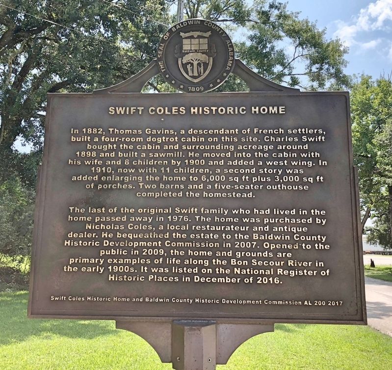
| 1 ► Alabama, Baldwin County, Bon Secour — The Charles Swift Family / Swift Coles Historic Home — |
| On County Road 49 at Swift Coles Lane, on the left when traveling south on County Road 49. | |||
| 2 ► Alabama, Baldwin County, Fort Morgan — The Pride of Seven Flags — |
| On Dixie Graves Parkway near Alabama Route 180 W. | |||
| 3 ► Alabama, Baldwin County, Gulf Shores — Battery Dearborn (1900-1924) — |
| Near Fort Morgan Road (State Road 180) 1 mile west of Dune Drive, on the left when traveling west. | |||
| 4 ► Alabama, Baldwin County, Gulf Shores — U.S. Model 1918M1 155mm Gun and Model 1918A1 Carriage — |
| On Fort Morgan Road (State Road 180) 1.7 miles west of Dune Drive, on the right when traveling west. | |||
| 5 ► Alabama, Baldwin County, Stockton — Baldwin County WWI Monument — |
| On Alabama Route 225, on the left when traveling north. | |||
| 6 ► Alabama, Barbour County, Clayton — In Loving Memory of the Clayton Soldiers of the World War — 1917 – 1918 — |
| On West Louisville Avenue at South Midway Street, in the median on West Louisville Avenue. | |||
| 7 ► Alabama, Barbour County, Eufaula — World War I Doughboy — |
| On East Broad Street at Orange Avenue, in the median on East Broad Street. | |||
| 8 ► Alabama, Blount County, Blountsville — None — Blountsville Court Square Timeline — |
| On Lee Street (County Road 26), on the right when traveling west. | |||
| 9 ► Alabama, Bullock County, Midway — Jefferson Davis Highway — |
| On Old Broadway Street (U.S. 82) at State Route 51, on the right when traveling south on Old Broadway Street. | |||
| 10 ► Alabama, Butler County, Greenville — Butler County World War I Memorial — |
| On East Commerce Street (Alabama Route 10) at South Conecuh Street (County Route 45), on the left when traveling east on East Commerce Street. | |||
| 11 ► Alabama, Butler County, Greenville — Butler County World War I Memorial — The United States World War One Centennial Commission — |
| Near Depot Square at Bolling Street. | |||
| 12 ► Alabama, Calhoun County, Anniston — “Spirit of the American Doughboy” — Anniston, Alabama — |
| On Quintard Avenue (U.S. 431), in the median. | |||
| 13 ► Alabama, Calhoun County, Anniston — Calhoun County World War I Memorial — 1917 - 1919 — |
| On Quintard Avenue at East 10th Street, in the median on Quintard Avenue. | |||
| 14 ► Alabama, Calhoun County, Anniston — The Legacy of the Military / Anniston's Military Heritage — |
| On Quintard Avenue at East 17th Street, on the right when traveling north on Quintard Avenue. | |||
| 15 ► Alabama, Calhoun County, Saks — 27th. Division Veterans Memorial — |
| Near Museum Drive north of Regar Circle, on the left when traveling north. | |||
| 16 ► Alabama, Chambers County, LaFayette — Chambers County War Memorial — |
| On Lafayette Street (U.S. 431), on the right when traveling north. | |||
| 17 ► Alabama, Chambers County, Valley — Armed Forces Tribute — |
| On Boulevard, 0.1 miles south of Lafayette Street, on the right when traveling south. | |||
| 18 ► Alabama, Chilton County, Clanton — Chilton County Veterans Memorial — |
| On 2nd Avenue North at 1st Street North, on the right when traveling west on 2nd Avenue North. | |||
| 19 ► Alabama, Clarke County, Grove Hill — Colored and White Soldiers of World War I — |
| Near West Cobb Street. | |||
| 20 ► Alabama, Clarke County, Jackson — The Clarke County War Memorial — |
| On Commerce Street (Alabama Route 177) near South Portis Avenue, on the right when traveling west. | |||
| 21 ► Alabama, Clay County, Ashland — Clay County Veterans Memorial — |
| On 1st Avenue (Alabama Route 9) at 2nd Street (Alabama Route 77), on the right when traveling west on 1st Avenue. | |||
| 22 ► Alabama, Colbert County, Muscle Shoals — Wilson Dam — |
| 23 ► Alabama, Colbert County, Muscle Shoals — Wilson Dam: Setting the Stage — |
| Near Reservation Road, 1 mile east of Alabama Route 133, on the left when traveling east. | |||
| 24 ► Alabama, Colbert County, Sheffield — 101 Memorial — World War I — |
| 25 ► Alabama, Colbert County, Sheffield — In Memory of Our Comrades of Sheffield — 1917 - 1919 — |
| On South Montgomery Avenue at East Blake Street, on the right when traveling north on South Montgomery Avenue. | |||
| 26 ► Alabama, Colbert County, Sheffield — Nitrate Plant No. 1 — |
| On West 20th Avenue west of Treatment Plant Road, on the right when traveling west. | |||
| 27 ► Alabama, Colbert County, Sheffield — Village One — |
| On Wilson Dam Avenue at Pickwick Street on Wilson Dam Avenue. | |||
| 28 ► Alabama, Colbert County, Tuscumbia — Colbert County World War I Memorial — April 6, 1917 — November 11, 1918 — |
| On North Main Street at West 3rd Street, on the right when traveling south on North Main Street. | |||
| 29 ► Alabama, Conecuh County, Evergreen — Conecuh County War Memorial — |
| On East Front Street at Cemetery Avenue, on the right when traveling east on East Front Street. | |||
| 30 ► Alabama, Covington County, Andalusia — Covington County Veterans Memorial Park — |
| Near E 3 Notch Street at 6th Avenue. | |||
| 31 ► Alabama, Covington County, Andalusia — Covington County War Memorial — |
| Near E 3 Notch Street at 6th Avenue. | |||
| 32 ► Alabama, Cullman County, Cullman — Cullman County World War I Memorial — |
| Near Sportsman Lake Road NW, 0.4 miles west of 2nd Avenue NW (Route 31). | |||
| 33 ► Alabama, Cullman County, Cullman — Marion Albert Hill — Nov. 13, 1895 — Feb. 3. 1979 — |
| Near Sportsman Lake Road NW, 0.4 miles west of 2nd Avenue NW (Route 31). | |||
| 34 ► Alabama, Dale County, Ariton — Veterans Memorial Bridge - 1921 / Grist Mill - Indian Battle - Recreation — |
| On U.S. 231 north of State Road 123, on the right when traveling north. | |||
| 35 ► Alabama, Dale County, Ozark — Dale Veterans Memorial — |
| On South Merrick Avenue south of West Broad Street (Alabama Route 27), on the left when traveling south. | |||
| 36 ► Alabama, Dallas County, Selma — Dallas County World Wars Memorial — Lest· We· Forget — World War I 1917-1918 — World War II 1941-1945 — |
| Near Dallas Avenue (Alabama Route 22) at Rowell Drive. | |||
| 37 ► Alabama, Dallas County, Selma — Lieutenant John Tillman Melvin — United States Navy R.F. — |
| On Lauderdale Street at Alabama Avenue, on the right when traveling south on Lauderdale Street. | |||
| 38 ► Alabama, Dallas County, Selma — Memorial Stadium — Selma Alabama — |
| Near Rowell Drive at Dallas Avenue (Alabama Route 22). | |||
| 39 ► Alabama, Elmore County, Wetumpka — Elmore County World War I Memorial — 1917 - 1918 — Elmore County, Alabama — |
| On South Main Street at Wharf Street, on the right when traveling north on South Main Street. | |||
| 40 ► Alabama, Escambia County, Brewton — Escambia County Veterans Memorial — |
| On Belleville Avenue at Henderson Street, on the right when traveling north on Belleville Avenue. | |||
| 41 ► Alabama, Etowah County, Gadsden — Etowah County War Memorial — |
| 42 ► Alabama, Fayette County, Berry — Alabama Christian College of Berry, Alabama — |
| On Main Street (Alabama Route 18) just north of Fenton Street, on the right when traveling north. | |||
| 43 ► Alabama, Greene County, Eutaw — Greene County Veterans Monument — |
| On Boligee Street (U.S. 11) at Springfield Avenue, on the right when traveling west on Boligee Street. | |||
| 44 ► Alabama, Henry County, Headland — Headland World War I Monument — |
| Near Main Street, 0.1 miles south of Alabama Route 173, on the right when traveling north. | |||
| 45 ► Alabama, Jefferson County, Bessemer — “Spirit of the American Doughboy” — Bessemer, Alabama — |
| On 3rd Avenue North south of 17th Street North, on the left when traveling south. | |||
| 46 ► Alabama, Jefferson County, Birmingham — Disabled American Veterans — |
| Near 2nd Avenue North near 3rd Street North. | |||
| 47 ► Alabama, Jefferson County, Birmingham — Osmond Kelly Ingram — 1887 - 1917 — |
| On 17th Street North at 6th Avenue North, on the right when traveling south on 17th Street North. | |||
| 48 ► Alabama, Jefferson County, Birmingham — The Rainbow Viaduct — Dedicated to the Brave Men of the 167th Infantry who fought to Preserve Our Freedom — |
| On Richard Arington Jr. Blvd North north of 1st Ave South, on the left when traveling north. | |||
| 49 ► Alabama, Jefferson County, Homewood — Union Hill Cemetery — |
| On Hollywood Boulevard east of Malaga Avenue, on the left when traveling east. | |||
| 50 ► Alabama, Jefferson County, Trussville — Trussville Furnace — 1889-1919 — |
| On Parkway Drive at North Mall, in the median on Parkway Drive. | |||
| 51 ► Alabama, Lamar County, Vernon — Lamar County WWI & WWII Memorial — |
| On Pond Street (Alabama Route 17) at 1st Avenue NE, on the right when traveling north on Pond Street. | |||
| 52 ► Alabama, Lauderdale County, Florence — 75mm Field Gun — |
| On Veterans Park Drive, 0.3 miles east of South Cox Creek Parkway (Alabama Route 133), on the left when traveling east. | |||
| 53 ► Alabama, Lauderdale County, Florence — Homer Givens — (1898 - 1971) — America's First World War I Hero — |
| On North Wood Avenue at Chisholm Road on North Wood Avenue. | |||
| 54 ► Alabama, Lauderdale County, Florence — Homer J. Givens — City of Florence Walk of Honor — |
| On South Cox Creek Parkway near River Heritage Park. | |||
| 55 ► Alabama, Lauderdale County, Florence — The American Legion — 1919 — |
| On S. Court Street at Dr Hicks Blvd. on S. Court Street. | |||
| 56 ► Alabama, Lauderdale County, Florence — World War I Memorial — |
| On Veterans Drive near Don Michael Drive. | |||
| 57 ► Alabama, Lauderdale County, Florence — World War I Memorial Amphitheater — |
| Near Shelby Way. | |||
| 58 ► Alabama, Lauderdale County, Florence — World War I Memorial Trees — |
| Near N. Woods Avenue. | |||
| 59 ► Alabama, Lauderdale County, Greenhill — World War I — |
| On 300 Rogers Lane. | |||
| 60 ► Alabama, Lawrence County, Hillsboro — Home of Annie Wheeler — |
| On Alternate U.S. 72 at County Road 377 on U.S. 72Alternate . | |||
| 61 ► Alabama, Lee County, Auburn — Auburn WWI Memorial — |
| On West Thach Avenue west of South College Street, on the right when traveling west. | |||
| 62 ► Alabama, Lee County, Opelika — Lieutenant Colonel Dallas B. Smith — March 9, 1883 - August 1, 1935 — |
| On 7th Avenue at North 6th Street, on the left when traveling east on 7th Avenue. | |||
| 63 ► Alabama, Limestone County, Salem — Cunningham Cemetery — Limestone County — |
| On Dupree Hollow Road (County Route 37) 0.5 miles south of Easter Ferry Road (County Route 104), on the left when traveling south. | |||
| 64 ► Alabama, Lowndes County, Lowndesboro — Our Confederate Soldiers — 1861 1865 — |
| Near North Broad Street, 1.5 miles north of U.S. 80, on the right when traveling north. | |||
| 65 ► Alabama, Madison County, Huntsville — Memorial Fountains — Huntsville Madison County Veterans Memorial — |
| On Monroe Street Northwest at Jefferson Street North, on the right when traveling west on Monroe Street Northwest. | |||
| 66 ► Alabama, Madison County, Huntsville — World War I — Huntsville Madison County Veterans Memorial — |
| On Monroe Street Northwest at Washington Street Northwest, on the left when traveling east on Monroe Street Northwest. | |||
| 67 ► Alabama, Madison County, Huntsville — World War I (Great War)/1914 – 1918 — |
| Near Monroe Street Northwest at Washington Street Northwest, on the left when traveling east. | |||
| 68 ► Alabama, Marshall County, Guntersville — Veterans of Foreign Wars Marshall County — |
| On Paddle Wheel Drive (U.S. 431) at Taylor Street, on the right when traveling north on Paddle Wheel Drive. | |||
| 69 ► Alabama, Mobile County, Mobile — Joseph (Joe) N. Langan — 1912 - 2004 — |
| Near Spring Hill Avenue at North Broad Street. | |||
| 70 ► Alabama, Mobile County, Mobile — Memorial Park — |
| On Government Street (U.S. 90) at Old Government Street on Government Street. | |||
| 71 ► Alabama, Monroe County, Uriah — Uriah Veterans Memorial — Honoring All Veterans — |
| On Alabama Route 21 at Alabama Route 59, on the right when traveling north on State Route 21. | |||
| 72 ► Alabama, Montgomery County, Maxwell Air Force Base — Air University / Maxwell Air Force Base — |
| On Ash Street west of Poplar Street, on the right when traveling west. | |||
| 73 ► Alabama, Montgomery County, Maxwell Air Force Base — Lt. William C. Maxwell / Air Force ROTC — |
| On Maxwell Boulevard at Magnolia Drive, on the right when traveling west on Maxwell Boulevard. | |||
| 74 ► Alabama, Montgomery County, Maxwell Air Force Base Gunter Annex — Army Air Corps Enlisted Pilots — 1912 — 1942 — |
| Near Avenue D at Libby Street. | |||
| 75 ► Alabama, Montgomery County, Montgomery — Alabama War Veterans Monument — |
| On North Jackson Street, 0.1 miles north of Pelham Street, on the right when traveling north. | |||
| 76 ► Alabama, Montgomery County, Montgomery — Flame of Freedom — |
| On South Union Street at Washington Avenue, on the left when traveling north on South Union Street. | |||
| 77 ► Alabama, Montgomery County, Montgomery — James Edwin Livingston — Twenty-Third Chief Justice — 1951-1971 — |
| Near Dexter Avenue at North Decatur Street, on the right when traveling east. | |||
| 78 ► Alabama, Montgomery County, Montgomery — Rainbow Soldier — Rainbow Division - Croix Rouge Farm - 167th Alabama Infantry Regiment - July 26, 1918 — |
| On Water Street west of Commerce Street, on the right when traveling west. | |||
| 79 ► Alabama, Montgomery County, Montgomery — Return from the Argonne — |
| On Water Street, 0.1 miles west of Commerce Street, on the right when traveling west. | |||
| 80 ► Alabama, Montgomery County, Montgomery — Royal Air Force Burial Ground — |
| Near Upper Wetumpka Road west of Vonora Avenue, on the right when traveling east. | |||
| 81 ► Alabama, Montgomery County, Montgomery — World War I Memorial — |
| Near Washington Avenue at South Union Street. | |||
| 82 ► Alabama, Montgomery County, Montgomery, Boylston — 167th Infantry / Alabama’s Own — (4th Alabama) — |
| On Johnson Avenue east of Lower Wetumpka Road, in the median. | |||
| 83 ► Alabama, Montgomery County, Montgomery, Boylston — 37th Division The Buckeye Division — World War I / World War II & Korea — |
| On Johnson Avenue east of Lower Wetumpka Road, in the median. | |||
| 84 ► Alabama, Montgomery County, Montgomery, Boylston — 9th Infantry Division / “The Old Reliables” — |
| On Johnson Avenue east of Lower Wetumpka Road, in the median. | |||
| 85 ► Alabama, Montgomery County, Montgomery, Forest Park — Remount Depot / Keyton Station — |
| On East Fifth Street at Jean Street, on the right when traveling east on East Fifth Street. | |||
| 86 ► Alabama, Montgomery County, Pike Road — Taylor Field — |
| On Ray Thorington Road (County Road 75) 0.8 miles west of Pike Road (County Road 85), on the left when traveling west. | |||
| 87 ► Alabama, Morgan County, Decatur — World War One — |
| On Line Street. | |||
| 88 ► Alabama, Pickens County, Carrollton — Pickens County War Memorial — |
| On Courthouse Square (Alabama Route 17) at Tuscaloosa Street (Alabama Route 86), on the left when traveling north on Courthouse Square. | |||
| 89 ► Alabama, Pike County, Troy — Pike County WWI Memorial — |
| On Elm Street at South Oak Street, on the left when traveling west on Elm Street. | |||
| 90 ► Alabama, Randolph County, Wedowee — World War I Memorial — |
| On N. Main St at West Broad Street, on the left when traveling north on N. Main St. | |||
| 91 ► Alabama, Russell County, Phenix City — Albert Love Patterson — January 27, 1891 - June 18, 1954 — |
| On 5th Avenue at 15th Street, on the left when traveling north on 5th Avenue. | |||
| 92 ► Alabama, Russell County, Phenix City — POW ✯ MIA Monument — |
| Near Dillingham Street north of Brickyard Road, on the left when traveling west. | |||
| 93 ► Alabama, Russell County, Seale — Holland McTyeire Smith — |
| On Oswichee Road (County Road 18) at McBride Street, on the left when traveling west on Oswichee Road. | |||
| 94 ► Alabama, Russell County, Seale — John Bacon McDonald — |
| On Longview Street, 0.4 miles north of Chapel Street, on the left when traveling north. | |||
| 95 ► Alabama, Russell County, Seale — William Augustus Mitchell |
| On Cutchin Drive (Alabama Route 26) just west of Old Seale Highway, on the right when traveling west. Reported missing. | |||
| 96 ► Alabama, Shelby County, Alabaster — Harless Cemetery — |
| On County Road 24, on the right when traveling south. | |||
| 97 ► Alabama, Shelby County, Columbiana — Shelby County War Memorial — |
| On North Main Street (County Route 47) north of West College Street, on the right when traveling south. | |||
| 98 ► Alabama, Tallapoosa County, Dadeville — Tallapoosa County World War I Memorial — |
| On North Broadnax Street (Alabama Route 49) at West Cusseta Street, on the right when traveling south on North Broadnax Street. | |||
| 99 ► Alabama, Tuscaloosa County, Tuscaloosa — French 75 Millimeter Feldhase — |
| On McFarland Boulevard East (U.S. 82), on the right when traveling north. | |||
| 100 ► Alabama, Walker County, Jasper — Walker County War Memorial — |
5370 entries matched your criteria. The first 100 are listed above. Next 100 ⊳