Near Puuhonua Road near Lower Nåpo'opo'o Road, on the right when traveling north.
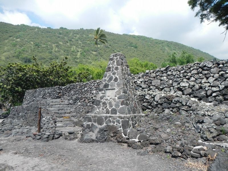
In this heiau
January-28-1779
Captain James Cook, R.N.
Read the English
Burial Service over
William Whitman, Seaman
the first recorded
Christian service
in the Hawaiian Islands — — Map (db m110794) HM
On Daniel K. Inouye Highway (Saddle Road) (Hawaii Route 200 at milepost 24) near Mauna Kea Access Road, on the right when traveling west.
Well before sheep and cattle ranching took hold in the second half of the nineteenth century, these rugged 'āina mauna, mountain lands, were traveled for collecting birds and rock or for religious purposes. Rock from Maunakea adze quarries at . . . — — Map (db m111118) HM
On Waianuenue Avenue (County Route 200) near Ululani Street, on the left when traveling east.
Traditions tell us that the larger Naha Stone was brought by canoe to Hilo from the chiefly valley of Wailua on Kaua'i by Chief Makali'inuikuakawaiea centuries ago. The stone had a place of honor at one of several heiau in Hilo and was said . . . — — Map (db m111114) HM
Near Kaahumanu Place near Palani Road, on the left when traveling north.
Upon this paepae (stone platform) is a representation of Ahu;ena Heiau. Restored by Kamehameha I upon the unification of the pae'aina (island chain), he rededicated Ahu'ena to Lono, the god of peace and prosperity. The Hale O Lono (House of Lono) . . . — — Map (db m110669) HM
On Alii Drive at Sarona Road, on the right when traveling north on Alii Drive.
Hulihe‘e Palace
Construction of Hulihe‘e Palace was completed in 1838. Hulihe‘e was the gracious residence of Governor John Adams Kuakini and a favorite retreat for Hawai‘i’s royal families. Kuakini oversaw the construction of both . . . — — Map (db m39424) HM
Near Palani Road near Kaahumanu Place, on the left when traveling north.
Home of Kamehameha I, founder of the Hawaiian Kingdom, from 1812 until his death. Here he built his residence, storehouses and fishponds and remodeled 'Ahu'ena Heiau, a temple of great antiquity. When he died here May 8 1819, his son Liholiho was . . . — — Map (db m110592) HM
On Kaahumanu Place near Palani Road, on the left when traveling north.
Kamakahonu
After uniting the Hawaiian kingdom, Kamehameha I returned to rule from his compound at Kamakahonu (lit. eye of the turtle) from 1812 until his death in 1819. 'Ahu'ena Heiau, the religious temple that served Kamehameha was rebuilt . . . — — Map (db m110665) HM
Near Alii Drive near Kahikina Lane, on the left when traveling north.
This sacred pond was built with lava rock and coral mortar in the mid 1800's. It once served as a bathhouse for the royal families. Fresh water empties into Ki’ ope pond through underground springs along the edges of the wall. Because of its rich . . . — — Map (db m123291) HM
On Ali'i Drive near Makolea Street, on the right when traveling south.
In the past, Hawaiian religious practices included the worship of many gods, both through individual and family rituals at small shrines and through larger community ceremonies at heiau (temples) such as this one. In 1819, King Kamehameha II . . . — — Map (db m110675) HM
On Alii Drive at Sarona Road, on the right when traveling north on Alii Drive.
The first Hawaiian Christian,
Henry Opukahaia,
died at Cornwall, Conn. 1818
The first Christian
missionaries to Hawaii,
Bingham, Thurston, Whitney,
landed at Kailua, April 12, 1820
with their Hawaiian comrades
Hopu, . . . — — Map (db m39440) HM
A heiau (temple) at Pu’ukohola was built long before Kamehameha started construction on the heiau that you see. This showed great vision and strategy on the part of the kahuna (priests). The heiau was physically very prominent and imposing on the . . . — — Map (db m71886) HM
Welcome to Pu’ukohola Heiau, one of the most famous heiau (temples) in the Hawaiian Islands. This heiau is an integral component of the traditional Hawaiian social, political, and religious systems, and a significant place in the history of King . . . — — Map (db m71874) HM
Near Kaleiopapa Street near Ehukai Street, on the right when traveling north.
Kauikeaouli and Nāhi'ena'ena
An inscribed stone tablet commemorates the nearby birth site of Kauikeaouli who went on to rule Hawai'i as King Kamehameha III. His sister, Princess Nāhi'ena'ena, was also born in Keauhou about . . . — — Map (db m110300) HM
First Church in the Islands
this building erected in 1836
model of brig "Thaddeus"
on exhibit. Open Daily from
dawn to dusk. Komo mai — — Map (db m190118) HM
Near Ninole Loop Road, 1 mile Mamalahoa Highway (Hawaii Route 11) when traveling east.
The mystical turtle, Kauila, makes her home in the Ka’u District at Punalu’u Bay. According to Hawaiian mythology, Kauila was empowered with the ability to turn herself from turtle into human form and would play with the children along the . . . — — Map (db m129454) HM
As these massive volcanoes move away from the hot spot, they cease to erupt, and slowly erode to become atolls, lagoons, and expansive sholes of coral reef. The island of Mokumanamana rises from the sea about halfway along the island chain and . . . — — Map (db m111014) HM
Near Chain of Craters Road (at milepost 16.3), on the left.
Honor the profound importance of Pu'uloa and its petroglyphs holds for many native Hawaiians - the past, present, and the future. Respect that importance by staying on the boardwalks so that their stories may live forever.
Ancient . . . — — Map (db m110976) HM
Near Chain of Craters Road (at milepost 16.3) near Hilina Pali Road, on the left when traveling south.
We come to Pu'uloa because we want what's best for our keiki (children). Pu'uloa holds two of my children's piko, There kūpuna (elders) brought them here and created the puka where there piko would rest, sealed under a stone These two . . . — — Map (db m110978) HM
Near Old Mamalahoa Highway near Old Onomea Road, on the right when traveling north.
In the beginning in Hawaiian mythology, Po was a vast and dark empty land. Only one life form dwelled there. It was the spirit of Keawe, his single light shining and holding the energy of creation. Keawe evolved order. He opened his great calabash . . . — — Map (db m110860) HM
Near Old Mamalahoa Highway near Old Onomea Road, on the right when traveling north.
In 1977 Dan and Paulin Lutkenhouse purchased this land to create a botanical garden for the education and enjoyment of the public. This bell was hanging in the steeple of an old church that was the Garden's first visitor center. In 1988 the church . . . — — Map (db m110859) HM
Near Old Mamalahoa Highway near Old Onomea Road, on the right when traveling north.
The village of Kahali'i was located on this large point of land which extends into Onomea Bay. Though the village is gone, the descendants of Kahali'i still remember some of the legends concerning the area's landmarks. One story tells of the . . . — — Map (db m110862) HM
Near Crater Rim Drive near Mauna Loa Road, on the left when traveling west.
Oli (chants) and mo'olelo (stories of this region recount the celebrated battle between Pelehonuamea (Pele, the volcano deity) and her sister, Hi'iakaikapoliopele (Hi'iaka), that erupted here at the summit of Kīlauea.
After a series of . . . — — Map (db m111041) HM
Near Waikoloa Beach Drive near Ku'uali'i Place, on the right when traveling north.
Liholiho ascended the throne at a time when foreign influences, and new standards and ideas were propelling the Hawaiians into the modern western world. During his reign, the kapu system was abolished and the missionaries arrived, brining . . . — — Map (db m108956) HM
Near Kawaihae Road near Kawaihae Harbor Road, on the left when traveling north.
The submerged remains of Hale o Kapuni Heiau, a temple dedicated to shark akua (deities), are believed to lie just offshore. The heiau was built by a chief whose family revered sharks, believing that the family's 'aumākua (deified ancestors) . . . — — Map (db m110377) HM
Near Kawaihae Road (Hawaii Route 270), on the left when traveling north.
The remains of Mailekini Heiau, a temple used before the time of Kamehameha, stand before you. Many mysteries surround Mailekini Heiau; its early history, kept orally and secretly within the priesthood, was never recorded. Historians agree that . . . — — Map (db m110367) HM
Near Kawaihae Road near Kawaihae Harbor (Hawaii Route 270), on the left when traveling north.
Build a heiau on Pu'ukoholā, the "hill of the whale," dedicate it to your war god, and you will achieve your dream - you will rule the islands. Responding to this prophecy told by Kapoykahi, a famous seer, Kamehameha built the . . . — — Map (db m110330) HM
Near Spencer Beach Park Road, 0.2 miles west of Kawaihae Road (Hawaii Route 270), on the right when traveling west.
Build a heiau on Pu'ukohola, the "hill of the whale," dedicate it to your war god, and you will achieve your dream — you will rule the islands. Responding to this prophecy told by Kapoukahi, a famous seer, Kamehameha built the heiau . . . — — Map (db m172849) HM
On South Beretania Street north of Punchbowl Street, on the left when traveling north.
Greater love has no man than this, that a man lay down his life for his friends. —John 15:13
Born a farmer’s son at Tremeloo, Belgium, January 3, 1840. Damien joined the Missionary Congregation of the Sacred Heart and was ordained a . . . — — Map (db m13485) HM
On Punchbowl Street at South King Street, on the left when traveling south on Punchbowl Street.
A Centennial Memorial of Hiram Bingham. Born in Bennington, Vt., Oct. 30, 1789. Died in New Haven, Ct., Nov. 11, 1869, Aged 80 Years.
This slab is placed here in grateful remembrance of a pioneer Missionary by descendants of Hawaiians . . . — — Map (db m13800) HM
On Punchbowl Street at South King Street, on the left when traveling south on Punchbowl Street.
William Charles Lunalilo was the kingdom’s sixth
monarch and proved to be very popular from the
beginning of his reign. King Kamehameha V had
preceded Lunalilo and had died without naming a successor. Therefore Lunalilo was appointed by the . . . — — Map (db m13809) HM
On Punchbowl Street, on the left when traveling east.
Built of gaint coral slabs, hewn from ocean reefs, this sanctuary became known as The Stone Church.
This structure was preceded by a succession of four thatched grass buildings which served as houses of worship until ground was broken in 1837. . . . — — Map (db m74145) HM
On Punchbowl Street, on the left when traveling east.
In the middle of an otherwise dry and barren plane, existed a sacred spring on these grounds, reserved for use by high chiefs and chiefesses only. Legend tells us that among the high ranking who enjoyed the privilege of bathing in the large circular . . . — — Map (db m74144) HM
On Punchbowl Street at South King Street, on the left when traveling south on Punchbowl Street.
King Kamehameha V died on December 11, 1872, without naming a successor to the throne. Prince William Charles Lunalilo was the highest ranking Chief at that time. Instead of claiming his birthright to the throne, he wanted the people to choose their . . . — — Map (db m13788) HM
On Punchbowl Street, on the left when traveling east.
Born in 1824 at Mokuleia Oahu
Educated by James Hunnewell at Lahainaluna
First Hawaiian Christian Minister
Ordained at Kahuku December 21 1849
In 1853 he went as a pioneer missionary to
the Marquesas . . . — — Map (db m74147) HM
From olden times Waikīkī was viewed not only as a place of peace and hospitality, but of healing.
There was great mana (spiritual power) in Waikīkī. Powerful kahuna la‘au lapa‘au (or physicians) lived here. Throughout the . . . — — Map (db m13225) HM
While travelling around the world on an assignment to visit the
foreign missions of The Church of Jesus Christ of the Latter-day Saints,
Elder David O. McKay, a member of the Quorum of the Twelve Apostles, and
Hugh J. Cannon visited Hawaii in . . . — — Map (db m111520) HM
This is the site of the LDS Hawaii Mission School
where President David O. McKay, then member of
the Church’s Quorum of the Twelve Apostles,
witnessed a flag raising ceremony on February 7, 1921.
Observing the multi-ethnic student body . . . — — Map (db m111519) HM
Near Damien Road, on the left when traveling south.
St. Philomena Church is the only remaining building from the early settlement at Kalawao. The original church on this site was built by Brother Victorin Bertrant in 1872, about a year before Father Damien arrived at the settlement. Assisted by . . . — — Map (db m184696) HM
On Damien Road, on the right when traveling south.
Father Damien recognized the special needs of children at the settlement. In 1886 he organized a home for boys. By 1894 the home included 29 separate structures on this site. The line of tall palms bordering the far side of this field marked the . . . — — Map (db m184697) HM
Near Kuhio Highway (State Highway 560) at Mahimahi Road.
The Waioli Mission Hall was established by American Christian missionaries in 1834. A pole and thatch meeting house was constructed by Hawaiians on this site, in anticipation of the arrivals of the missionaries. The first meeting house was destroyed . . . — — Map (db m9804) HM
On Waikomo Road south of Koloa Road, on the right when traveling south.
Buddhist temples provided Japanese immigrants a place to worship, study their language, learn martial arts and participate in social events. This Jodo Mission used a specialist in temple architecture from Japan to build the large temple’s interior. . . . — — Map (db m13007) HM
On Poipu Road (Hawaii Route 520) south of Koloa Road (Hawaii Route 530), on the left when traveling south.
Kōloa Missionary Church sanctuary is part of a homestead once owned by Dr. James W. Smith, a medical missionary. In 1842, he began a practice of over 40 years, later becoming an ordained minister at The Church at Kōloa. His grandson, Dr. . . . — — Map (db m13023) HM
Near Poipu Road east of the Poipu Road traffic circle, on the right when traveling east.
The walled heiau (temple) that once stood here was 130 feet by 90 feet; dedicated to Kāne, a major god of Hawai‘i, Hulokoki, a bird god, Kū-hai-moana and Ka-moho-ali‘i, two shark gods. Three hala-lihilihi-‘ula trees situated on the outside . . . — — Map (db m12803) HM
Kipahulu-Founded 1864-We welcome visitors to this historic, missionary church in Kipahulu. Out of respect for church members, relatives & descendants of those buried in the graveyard, we ask that you treat this religious site with reverence & care. — — Map (db m71842) HM
Holy Ghost Catholic Church has been placed on the National Register of Historic Places by the United States Department of the Interior — — Map (db m71770) HM
A heiau is a Hawaiian religious structure which centralized the ceremonies and rituals of old Hawaii. The construction of a heiau was directed by the highest chiefs or alii and required a great expenditure of organized labor. The ceremonies and . . . — — Map (db m71864) HM
In the distant future, when our descendants ask, tell them here lies the first altar made by Korean American Christians.
Today, when more than three thousand Korean churches in America, along with their members ask, tell them you all are . . . — — Map (db m73191) HM