On Chambersburg Road (U.S. 30), on the right when traveling east.
Surveyed in 1766. Named for an estate in England. The Manor was about 6 miles wide and 12 miles long with the southern boundary at present Mason-Dixon Line. It was the second largest reserved estate of the Penns in Pennsylvania. The western boundary . . . — — Map (db m11623) HM
On Steelman Marker Road at Topper Road (Local Route 312), on the right when traveling north on Steelman Marker Road.
Indian trader and interpreter of Maryland and Pennsylvania. First settler in this valley. Born of Swedish parents along the Delaware. This tablet erected by Liberty Twp. and Fairfield Area Bicentennial Cmte. First Marker Placed in 1924 by . . . — — Map (db m29543) HM
On Steinwehr Avenue (Business U.S. 15), on the right when traveling south.
Built in 1776 by the Rev. Alexander Dobbin. In use for some 25 years as one of the first classical schools west of the Susquehanna River. It is now a museum refurnished in keeping with the early period. — — Map (db m122380) HM
Here the Shippensburg-Baltimore and the Philadelphia-Pittsburgh Roads crossed. Near the crossroads, stood the tavern of Samuel Gettys. In 1775, troops gathered here for Continental service. — — Map (db m17045) HM
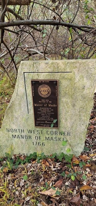
On Horner Road just south of Mason Dixon Road, on the right when traveling north.
This site was part of the Manor of Maske warranted by John, Richard, and Thomas Penn Proprietors of Pennsylvania June 18, 1741 Surveyed January 17-30, 1766 Containing 43,500 acres (Around the edges are the survey annotations): North 3842 . . . — — Map (db m192379) HM
On Emmitsburg Road (Business U.S. 15), on the right when traveling south.
This site was part of the Manor of Maske warranted by John, Richard, and Thomas Penn Proprietors of Pennsylvania June 18, 1741 Surveyed January 17-30, 1766 Containing 43,500 acres (Around the edges are the survey annotations): North 3842 . . . — — Map (db m203087) HM
On Baltimore Street (Business U.S. 15) just south of West Middle Street (Pennsylvania Route 116), on the right when traveling south.
This site
was part of the
Manor of Maske
Warranted by
Joh, Richard, and
Thomas Penn
Proprietors of Pennsylvania
June 18, 1741
Surveyed
January 17-30, 1766
containing 43,500 acres
North 3842 . . . — — Map (db m241691) HM
On York Street (U.S. 30), on the right when traveling west.
Surveyed in 1766. Named for an estate in England. The Manor was about 6 miles wide and 12 miles long with the southern boundary at present Mason-Dixon Line. It was the second largest reserved estate of the Penns in Pennsylvania. The eastern boundary . . . — — Map (db m13939) HM
On Basilica Drive just south of Chapel Drive, on the right when traveling north.
The Catholic Faith was brought from Maryland about 1730 to Conewago which became an important Jesuit mission foundation.
From here the faith spread over a great area of Pennsylvania and Western Maryland.
A log chapel was built . . . — — Map (db m180227) HM
On Basilica Drive just south of Chapel Road, on the right when traveling north.
The stone used in the construction of this building are from the Robert Owings "Mass House," which was erected approximately one-half mile directly north of this site on a 500 acre tract of land granted to him in 1732 by Lord Baltimore. . . . — — Map (db m159893) HM
On South Queen Street at East King Street, on the right when traveling north on South Queen Street.
Littlestown is situated at the intersection of the Old Monocacy Road (opened in 1736) and the Baltimore to Pittsburgh Road, (1770) later known as the Gettysburg and Petersburg Turnpike. The Old Monocacy Road was the road between Wrightsville, PA and . . . — — Map (db m231100) HM
On South Queen Street (Pennsylvania Route 97) at East King Street (Pennsylvania Route 194) on South Queen Street.
In honor of
Peter (Klein) Little
1724-1773
Founder of Littlestown
Founded in 1765
Originally named
"Kleina-Stedtle",
renamed in 1795 — — Map (db m147273) HM
On Christ Church Road, 0.2 miles north of Hanover Pike (Pennsylvania Route 194), on the right when traveling north.
The congregation was organized May 4, 1747 by the Rev. Michael Schlatter who was sent by the Synods of Holland to Pennsylvania.
On this site stood the first church, a log structure, which was replaced in 1798 by a brick church. This edifice . . . — — Map (db m14860) HM
On North Third Street north of Main Street (Route 116), on the right when traveling north.
A man of strong intellect and sturdy independence of character with a sincere interest in the welfare of the colonists he was chosen a colonial justice and also served as Chairman of the Committee on Safety for York County in 1774. Together with . . . — — Map (db m130318) HM
On Center Square north of Lincoln Way West (U.S. 30), on the right when traveling west.
This was a tavern site along the Marsh Creek Road as early as 1763. Operated by the Frederick Kuhn family from 1769 until 1791. In the next year son Henry Kuhn laid out, the town of Oxford here on part of his 256 acre property. Well located at . . . — — Map (db m130293) HM
On Main Street (Pennsylvania Route 94) at N D Alley, on the right when traveling north on Main Street.
This parish was founded in 1746, at Huntington, by the Rev. Richard Locke to whom the Episcopal churches in Carlisle and York also owe their founding.
Civil War Building
July 1863 — — Map (db m91233) HM
From whom McKeesport derives its name, first permanent white settler at the forks of the Monongahela and Youghiogheny Rivers in 1755. The Colonial Government granted to him exclusive right of ferrage over these rivers April 3, 1769, called . . . — — Map (db m29962) HM
On Oliver Avenue just east of Wood Street, on the right when traveling east.
In commemoration of the grant of this land for the Presbyterian Church and for Trinity Church by the heirs of William Penn in 1787, and in honor of the officers of the Colonial and Revolutionary Armies who after assisting in the achievement of . . . — — Map (db m156265) HM WM
In 1751, the legislators of the Province of Pennsylvania ordered from an English foundry "A Good Bell" for the new bell tower of the state house (now know as Independence Hall) in Philadelphia. It was to be the jubilee symbol of the Pennsylvania . . . — — Map (db m66452) HM
Near Commonwealth Place at Liberty Avenue, on the right when traveling south.
Point of Confluence
Nature itself has conspired to render the Ohio hereabouts a place of consequence and importance, and the rendezvous of all the people of North America that are within reach of it.
John Mitchell 1756 . . . — — Map (db m156277) HM
Near Commonwealth Place at Boulevard of the Allies, on the right when traveling south.
The flowers and berries from this widespread native plant feed pollinators, birds, and many mammals. People used the roots for medicine long before the French built Fort Duquesne here at the Point. — — Map (db m156274) HM
On Grant Street just north of Forbes Avenue, on the right when traveling north.
The day after the fall of Fort Duquesne, General Forbes wrote in a letter to William Pitt:–
"I have used the freedom of giving your name to Fort Duquesne, as I hope it was in some measure the being actuated by your spirits . . . — — Map (db m156215) HM
On East Circuit Road, 0.1 miles west of Serpentine Drive, on the right when traveling west.
Was present at the defeat of Braddock in 1755 and took part in all the subsequent wars until the Treaty of Greenville in 1795, after which he remained the friend and ally of the United States. — — Map (db m65044)
At the bottom of the cliff on which Kennywood sits, the largest British army assembled up until then in the American colonies... with flags flying and drums beating... forded the Monongahela on July 9, 1755. The battle that followed directly across . . . — — Map (db m76674) HM
On PA 51 Offramp at Station Street, on the right when traveling north on PA 51 Offramp.
The first colonial residents of Beaver County lived nearby. Alexander McKee operated a trading post 1769 or earlier. Colonel John Gibson farmed land near his trading post in 1771 then went on to a great military and legal career. McKee became a . . . — — Map (db m47789) HM
On East End Avenue, on the right when traveling north.
Despite the threat of Indian attack and the hardships of life on the frontier, early white settlers began trickling into the area south of the
Ohio River, attracted by fertile farmland, river transportation, and an abundance of natural resources. . . . — — Map (db m176916) HM
On East End Avenue, on the right when traveling north.
Prior to the 17th century, the area we know today as Beaver County was inhabited by the Monongahela People, of whom we
know little. These early natives disappeared from the area sometime in the early 1600s.
The earliest European visitors to the . . . — — Map (db m176915) HM
On Pitt Street (Business U.S. 30), on the left when traveling west.
A log structure, built prior to 1761, stood on this site. Known, also, as the Commandants House; later as “Rising Sun Inn.” Occupied by British officers until close of French and Indian War. Destroyed by fire, Dec. 14, 1885. — — Map (db m14004) HM
On Juliana Street at Penn Street, on the right when traveling south on Juliana Street.
Formed on March 9, 1771 from Cumberland County, it first embraced most of western Pennsylvania. Named for its county seat (formerly Raystown) incorporated 1795. In 1758, Fort Bedford was erected here, and Forbes Road - to become a major highway . . . — — Map (db m13990) HM
On Pitt Street (Business U.S. 30) 0 miles west of Richard Street (Pennsylvania Route 220), on the right when traveling west.
Built about 1771. It was the headquarters of George Washington in October, 1794, when he came to Bedford to review troops assembled here to quell Whiskey Rebellion in western part of the State. — — Map (db m14015) HM
On Juliana Street at Penn Street, on the right when traveling south on Juliana Street.
This tablet marks the site of the First Court House and Prison Built in 1774 in the prison yard around which was a high stone wall were The Pillory and Whipping Post used in those days for the punishment of criminals.
Prior to the . . . — — Map (db m14000) HM
On Pitt Street (Business U.S. 30) at Richard Street (Business U.S. 220), on the right when traveling west on Pitt Street.
Site of lots on which John Fraser and his wife established an inn and trading post in 1758. Fraser had been a guide and interpreter for Colonel Washington. The inn provided meals for army officers at Fort Raystown (Bedford). — — Map (db m166918) HM
This millstone, which dates prior to the American Revolution, came from Dutch Corner in Bedford County. Jim Karns found it in 1985 while doing construction work near Imlertown. The mill from which it came is unknown. This stone, which weighs about . . . — — Map (db m91117) HM
On East John Street at Huntingdon Avenue, on the right when traveling east on East John Street.
(Statement):
A full transcript of the original Presbyterian Burial Ground Patent is available to all those interested from the Memorial Park Conservancy
In June, 1766, in pursuance of an order from his Honour the Governor John Penn, . . . — — Map (db m176390) HM
On Pitt Street (Business U.S. 30) at Telegraph Road, on the left when traveling west on Pitt Street.
Settled about 1750, known then as Raystown. Site of an early trading post and Fort Bedford, 1758. Base for Forbes, Bouquet expeditions. In 1794 Washington here reviewed forces in Whiskey Rebellion. — — Map (db m13995) HM
Founded 1681 by William Penn as a Quaker Commonwealth. Birthplace of The Declaration of Independence and The Constitution of the United States — — Map (db m91128) HM
On Lincoln Highway (U.S. 30) 0.2 miles west of Market Street (Pennsylvania Route 96), on the right when traveling west.
Near here was located Shawnee Cabins camp. Used by Gen. Forbes army in the campaign of 1758 against the French at Fort Duquesne in present Pittsburgh. — — Map (db m8288) HM
On Lincoln Highway (U.S. 30) 0.2 miles west of Market Street (Pennsylvania Route 96), on the right when traveling west.
Shawnee Cabins Encampment
At this point
the Forbes Road
leads southwestward
to
the eastern slope
of
the Allegheny Mountains
8 1/3 miles from Fort Bedford — — Map (db m49562) HM
On Lincoln Highway (U.S. 30) 0.2 miles west of Market Street (Pennsylvania Route 96), on the left when traveling west.
A village site nearby on the Raystown Path. Named for a group of Shawnee Indians who halted here on their retreat from the Potomac to the lower Allegheny valley in the early 18th century. — — Map (db m8290) HM
On Main St. (PA 100) at 7th Street on Main St. (PA 100).
Re-named Bally for Father Augustin Bally. The third Roman Catholic mission and first Catholic school in the State were established here in 1743 by Father Theodore Schneider — — Map (db m84570) HM
On Christmas Village Road (Pennsylvania Route 4010) at Groff Road on Christmas Village Road.
Organized 1729, this is one of the early Lutheran churches founded by Rev. John Caspar Stoever, Jr., who started the parish records in 1730. A log church, erected before 1749, was replaced by the present stone building in 1809. Since 1853, Lutheran . . . — — Map (db m84515) HM
On Lancaster Avenue (Pennsylvania Route 501) at Fort Henry Road (Local Road 956), on the left when traveling north on Lancaster Avenue.
Built 1756; garrisoned during the French and Indian War by troops under Capt. Christian Busse. Pennsylvania's major frontier defense east of Ft. Augusta (Sunbury). The site is 3/4 mile to the northwest. — — Map (db m29547) HM
On East Main Street (Pennsylvania Route 345/724) just east of North Mill Street, on the left when traveling east.
William Bird c 1706-1761
In 1751, William Bird, pioneer ironmaster, built the stone mansion which now houses the Birdsboro Community Memorial Center. The home which faced the Schuylkill River, was conveniently situated across . . . — — Map (db m160550) HM
On East Main Street (Pennsylvania Route 345) just west of North Water Street, on the right when traveling west.
Birdsboro Trailhead
The trailhead here at Birdsboro was developed for use by trail users through the efforts of the Community of Birdsboro and Schuylkill River Heritage Area. The trailhead provides visitors with easy access and . . . — — Map (db m160540) HM
On Benjamin Franklin Highway (U.S. 422) 0.2 miles east of Hillview Road, on the right when traveling east.
Famous pioneer and wilderness scout, who lived in this area his first 16 years. Born 3 miles northwest on site of Daniel Boone Homestead, State historical shrine. — — Map (db m25167) HM
On Baumstown Road (U.S. 422), on the right when traveling east.
Greatest American pioneer and wilderness scout. Born Nov. 2, 1734. Spent the first 16 years of his life on the Boone Homestead a few miles north. Now a State historical shrine dedicated to American youth. — — Map (db m23776) HM
On East Baumstown Road (U.S. 422) at Center Road (Pennsylvania Route 82/345), on the right when traveling west on East Baumstown Road.
Hopewell Forge, 1744, and Furnace, 1770, were seven miles south. The furnace and the remains of an iron making community of the era are administered by the National Park Service, with recreation areas. — — Map (db m23784) HM
On Benjamin Franklin Highway (U.S. 422) 0.2 miles west of Limekiln Road, on the right when traveling east.
On his first visit to America
1682 - 1684
came farthest north
on Schuylkill River
fifty miles up
from the Falls of Schuylkill
to or near the mouth of Monocacy Creek
three fourth of a mile
south-[direction erased] of this marker . . . — — Map (db m25202) HM
On South Reading Avenue at Farmington Avenue on South Reading Avenue.
Established on Iron Stone Creek, one half mile to the east, by James Lewis, Anthony Morris, Thomas Potts, and Thomas Rutter. Called after Colebrookdale Furnace in England, it is considered the first blast furnace to be erected in Pennsylvania, c. . . . — — Map (db m84544) HM
Pioneer ironmaster and opponent of slavery who died 1730. Built Pennsylvania's first ironworks nearby, 1716. In ensuing decade he erected Pine Forge and built this mansion; in 19th century it was an Underground Railroad stop. Academy was founded . . . — — Map (db m84540) HM
On Benjamin Franklin Highway (U.S. 422) at Church Lane, on the right when traveling east on Benjamin Franklin Highway.
Polish pioneer, Indian trader, settled along Schuylkill River in this area, 1712. He served the Provincial government as a messenger-interpreter during negotiations with Indian tribes in 1728. He was buried, 1736, in graveyard of St. Gabriel's . . . — — Map (db m25273) HM
In memory of
Anthony Sadowski
Born c.1669 in Poland
Died April 22, 1736
Whether or not he opened an Indian trading post on the shores of Lake Erie, and gave his name to Sandusky, Ohio, here lies the greatest Polish frontiersman of . . . — — Map (db m25276) HM
On Old Philadelphia Pike, 0.1 miles north of Britton Street, on the right when traveling north.
A Country Manor
George Douglass (1726-1799) was from a prosperous Chester County farm family. After working as a saddler and innkeeper in Reading, he moved to Morlatton by 1762 with his wife, Mary Piersol Douglass (1731-1798). Douglas soon . . . — — Map (db m160505) HM
On Old Philadelphia Pike, 0.1 miles north of Britton Street, on the left when traveling north.
Located along a ford on the Schuylkill River, Morlatton Village was established in the 18th century with the arrival of Mouns Jones and his family from modern Philadelphia. Others soon followed, becoming a part of a diverse regional settlement . . . — — Map (db m160513) HM
On Old Philadelphia Pike, 0.1 miles north of Britton Street, on the left when traveling north.
Morlatton Village Trailhead
Morlatton Village Trailhead was developed for use by trail users though the efforts of the Schuylkill River Heritage Area and the Historic Preservation Trust of Berks County. The trailhead provides with . . . — — Map (db m160514) HM
Near Old Philadelphia Pike, 0.1 miles north of Britton Street, on the left when traveling north.
Oldest Documented House in Berks County
Mans Jonasson (1663-1727) was descended from Swedes who settled in present day Philadelphia, along with the lower Delaware and Schuylkill Rivers, in 1638. Later known as Mouns Jones he was the first . . . — — Map (db m160529) HM
Near Old Philadelphia Pike, 0.1 miles north of Britton Street, on the left when traveling north.
An Early Riverside Settlement
The Schuylkill River played an important role in the settlement and growth of Amity and Union Townships. A shallow crossing at this location allowed people and wagons to ford the river and may have been one . . . — — Map (db m160535) HM
Wealthy and influential colonial settlers.
George Douglass built his family mansion here
and also the White Horse Tavern in 1765.
This stage coach stop was of historical
importance during the Revolutionary War.
Douglassville was named . . . — — Map (db m25279) HM
On Old Philadelphia Pike just north of Britton Street, on the left when traveling north.
In 1701 William Penn granted 10,000 acres of land to seventeen colonists of Swedish descent who were living in present day Philadelphia. The village within the Swedes' Tract was called Morlatton and by 1719 the entire tract became Amity Township, . . . — — Map (db m160499) HM
On Old Philadelphia Pike at Britton Street on Old Philadelphia Pike.
A Wayside Inn
The first innkeepers on the White Horse tract were Swedish settler Marcus Huling and his wife, Margareta, a daughter of Mouns and Ingeborg Jones, the area's earliest European settlers. The Hulings' inn was established in the . . . — — Map (db m160503) HM
On Meetinghouse Road at Boone Road on Meetinghouse Road.
Established 1725 as Oley; name changed to Exeter, 1742. Present stone meeting house built 1759 near site of two previous log structures. Buried here are members of the Boone, Ellis, Hughes, Lee, and Lincoln families. Meetings discontinued 1899; . . . — — Map (db m84536) HM
First European settlers in present Berks County on land granted by William Penn, 1704-5. The home of Mounce and Ingeborg Jones, built 1716 and the oldest house in the county, stands at the opposite end of the river bridge. — — Map (db m84538) HM
On Church Street north of Pine Street, on the right when traveling north.
To the memory of
Martin Kaercher Jr.
Founder of Hamburg
Martin Kaercher Sr., born in Germany in 1718, emigrated to Berks County in 1738. On Dec. 23, 1772 he acquired 'a certain tract of land called Hamburg' embracing 250 acres of . . . — — Map (db m141067) HM
Established by Thomas Maybury in 1745 on the west bank of the Perkiomen Creek for the purpose of manufacturing iron. Maybury is credited with producing here in 1767 the first cast-iron cooking-stove in North America. — — Map (db m84571) HM
In Colonial America, the Dutchman of eastern Pa. grew the nation's wheat & the Scotch-Irishman of western Pa. made the nation's rye whiskey. Both the flour from the wheat & the whiskey were barreled for shipment to eastern seaboard markets. To . . . — — Map (db m105360) HM
The Mennonites were named for Menno Simmons, a 16th century Dutch leader. They are descendants of the 16th century religious radicals who were known as Anabaptists. They wanted to reserve the rite of baptism for those adults who had made a . . . — — Map (db m105513) HM
On Luckenbill Drive, 0.2 miles west of Kutztown Road, on the left when traveling west.
relocated from
Exeter Township, Berks County, PA
in honor of
Sterling G. & Florence M. Zimmerman
with generous support from the
Grundsau Lodges. — — Map (db m105345) HM
On Sally Ann Furnace Road at Mine Road, on the right when traveling south on Sally Ann Furnace Road.
Originally built as a charcoal furnace by
Valentine Eckert 1791
Nicholas Hunter owner 1803
Operated by
Nicholas Hunter and Son 1804-1825
Jacob Van Reed Hunter (son) 1825-1861
J.Nicholas Hunter and Henry A. Hunter 1861-1869
(Changed . . . — — Map (db m216394) HM
On Memorial Hwy. (PA 73/662), at DeTurk Road on Memorial Hwy. (PA 73/662),. Reported missing.
Built in 1767 by John de Turk, son of Isaac de Turk, a Huguenot who settled here in 1712 and was one of a number of French Protestants who were pioneers in this part of Berks County. — — Map (db m179602) HM
A building erected about 1748 by Moravians, for use as a church and school, stands on the side road, about 1.5 miles away. Here they conducted a boarding school, 1745-51; and built a later schoolhouse, since demolished, in 1776. — — Map (db m84525) HM
On 5th Street (Business U.S. 222) near Penn Street, on the left when traveling south.
In memory of
Col. Conrad Weiser,
Pioneer, soldier, diplomat, judge. As interpreter and Indian agent he negotiated every treaty from 1732 until near the close of the French and Indian War.
—————
The Weiser . . . — — Map (db m25272) HM
On Penn Street at 5th Street (Business U.S. 222), on the right when traveling west on Penn Street.
A hewn-log building, erected on this site about 1750; operated until 1760 by Conrad Weiser, distinguished pioneer settler, treaty maker, Indian agent and interpreter, and first Berks County lay judge. — — Map (db m25270) HM
On Penn Street at 5th Street (Business U.S. 222), on the right when traveling west on Penn Street.
Site of Federal Inn, erected about 1754. George Washington, with military escort, was a guest here, October, 1794, when on his way to muster an armed force to suppress the Whiskey Rebellion. — — Map (db m25206) HM
On Washington Street (Business U.S. 422) at Reed Street, on the right when traveling west on Washington Street.
The heirs of Wm. Penn
donated and deeded the lots to
Conrad Weiser and Isaac Levan,
————Trustees.————
The first church was built of logs.
Rev. Wm. Stoy, 1755, was the first . . . — — Map (db m111824) HM
On Penn Street at South 2nd Street, on the right when traveling east on Penn Street.
Laid out 1748 by direction of Thomas Penn. Seat of Berks County since 1752. Incorporated borough, 1783. Soon became, and has remained, center of the Pennsylvania-Dutch area. An old and progressive industrial community. — — Map (db m161067) HM
On Schuylkill River Trail, 0.2 miles east of Brentwood Drive, on the left when traveling east.
Birth of Berks County
Settlement began with the Lenni-Lenape of the Delaware Nation. In 1681 William Penn founded Pennsylvania and in 1748 his sons Thomas and Richard established Readingtown. It became the county seat when Berks County was . . . — — Map (db m160558) HM
Near Red Bridge Road, 0.1 miles north of Union Canal Trail.
The Reeser house and farm at the Berks County Heritage Center survives as a witness to the agricultural lifestyle of early Berks County. First settled in the 1730s by English
Quakers, it was purchased by Abraham Reeser in 1774 and remained in the . . . — — Map (db m208905) HM
On Washington Street (U.S. 422) west of 6th Street, on the right when traveling west.
Dedicated to all who rest
in unmarked graves
One generation shall laud
thy works to another...
Psalm 145:4
———————————
Under this chapel lie the remains of
[Roll of . . . — — Map (db m111832) HM
On Union Canal Trail at Columbia Street, on the right when traveling north on Union Canal Trail.
Connecting Progress and History
In 1690, there were few navigable inland waterways in the Quaker colony established by William Penn. Penn recognized the need for a route by which to access and settle the lush countryside and harvest its . . . — — Map (db m160655) HM
Near River Road at Ashbourne Drive, on the left when traveling west.
The First Settlers
The Lenni-Lenape, or "original people", were the first to inhabit the banks of Ganshowahanna, or "falling waters", their name for the Schuylkill River. The Lenni-Lenapes in this area were members of the peaceful tribes . . . — — Map (db m161131) HM
On Reading Road (Pennsylvania Route 272) at Furlow Road, on the right when traveling west on Reading Road.
Early Shekelamy/Schuykill Indian paths led to this spring. In 1762, two of these paths were followed to construct the first road between Lancaster and Reading. In 1823 John and Nicolas Coleman opened a stage line stopping here to allow passengers . . . — — Map (db m234875) HM
On East Lancaster Avenue (US 222) at Mifflin Blvd. on East Lancaster Avenue (US 222).
Member of the Continental Congress, a Revolutionary soldier, first Pennsylvania governor, 1790-99, lived at his estate Angelica from 1774 to 1794. The Berks County Farm and Home now occupies the site. — — Map (db m84488) HM
1096 entries matched your criteria. The first 100 are listed above. Next 100 ⊳