After filtering for Pennsylvania, 1102 entries match your criteria. The first 100 are listed. ⊳
Colonial Era Topic
By Martin Rakoci, October 20, 2020
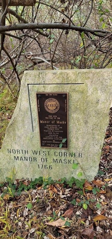
Manor of Maske Marker NW corner
| 1 ► Pennsylvania, Adams County, Biglerville, Franklin Township — Manor of Maske — |
| On Chambersburg Road (U.S. 30), on the right when traveling east. | |||
| 2 ► Pennsylvania, Adams County, East Berlin — East Berlin — |
| On West King Street (Pennsylvania Route 234) west of 6th Street, on the right when traveling east. | |||
| 3 ► Pennsylvania, Adams County, Fairfield, Liberty Township — John Hanson "Hance" Steelman — (1655-1749) — |
| On Steelman Marker Road at Topper Road (Local Route 312), on the right when traveling north on Steelman Marker Road. | |||
| 4 ► Pennsylvania, Adams County, Gettysburg — 226 — Dobbin House — |
| On Steinwehr Avenue (Business U.S. 15), on the right when traveling south. | |||
| 5 ► Pennsylvania, Adams County, Gettysburg — Gettys Crossroads and Tavern — |
| On York Street, on the right when traveling west. | |||
| 6 ► Pennsylvania, Adams County, Gettysburg, Cumberland Township — Manor of Maske — |
| On Horner Road just south of Mason Dixon Road, on the right when traveling north. | |||
| 7 ► Pennsylvania, Adams County, Gettysburg, Cumberland Township — Manor of Maske — |
| On Emmitsburg Road (Business U.S. 15), on the right when traveling south. | |||
| 8 ► Pennsylvania, Adams County, Gettysburg — Manor of Maske — |
| On Baltimore Street (Business U.S. 15) just south of West Middle Street (Pennsylvania Route 116), on the right when traveling south. | |||
| 9 ► Pennsylvania, Adams County, Gettysburg, Straban Township — Manor of Maske — [Eastern boundary] — |
| On York Street (U.S. 30), on the right when traveling west. | |||
| 10 ► Pennsylvania, Adams County, Hanover, Conewago Township — Conewago Chapel — |
| On Basilica Drive just south of Chapel Drive, on the right when traveling north. | |||
| 11 ► Pennsylvania, Adams County, Hanover, Conewago Township — Stones from the Mass House — |
| On Basilica Drive just south of Chapel Road, on the right when traveling north. | |||
| 12 ► Pennsylvania, Adams County, Littlestown — Littlestown — Early History — 1762-1815 — |
| On South Queen Street at East King Street, on the right when traveling north on South Queen Street. | |||
| 13 ► Pennsylvania, Adams County, Littlestown — Peter (Klein) Little — |
| On South Queen Street (Pennsylvania Route 97) at East King Street (Pennsylvania Route 194) on South Queen Street. | |||
| 14 ► Pennsylvania, Adams County, Littlestown, Union Township — Christ Reformed Church — |
| On Christ Church Road, 0.2 miles north of Hanover Pike (Pennsylvania Route 194), on the right when traveling north. | |||
| 15 ► Pennsylvania, Adams County, McSherrystown — McSherrystown — |
| On Main Street (Pennsylvania Route 116) 0.1 miles east of South 3rd Street, on the right when traveling east. | |||
| 16 ► Pennsylvania, Adams County, McSherrystown — Patrick McSherry — 1725 - 1795 — |
| On North Third Street north of Main Street (Route 116), on the right when traveling north. | |||
| 17 ► Pennsylvania, Adams County, New Oxford — Kuhn Tavern — 1763 — |
| On Center Square north of Lincoln Way West (U.S. 30), on the right when traveling west. | |||
| 18 ► Pennsylvania, Adams County, York Springs — Christ Church Episcopal — Colonial English Parish — Founded 1746 — |
| On Main Street (Pennsylvania Route 94) at N D Alley, on the right when traveling north on Main Street. | |||
| 19 ► Pennsylvania, Allegheny County, McKeesport — David McKee — 1710-1795 — |
| On Arboretum Drive east of Eden Park Boulevard. | |||
| 20 ► Pennsylvania, Allegheny County, Pittsburgh, Central Downtown Historic District — In Commemoration — |
| On Oliver Avenue just east of Wood Street, on the right when traveling east. | |||
| 21 ► Pennsylvania, Allegheny County, Pittsburgh, Central Downtown Historic District — Oliver Avenue — |
| On Oliver Avenue just east of Wood Street, on the right when traveling east. | |||
| 22 ► Pennsylvania, Allegheny County, Pittsburgh, Crawford-Roberts — "The Bell Speaks" — |
| 23 ► Pennsylvania, Allegheny County, Pittsburgh, Downtown — A Place of International Consequence — |
| Near Commonwealth Place at Liberty Avenue, on the right when traveling south. | |||
| 24 ► Pennsylvania, Allegheny County, Pittsburgh, Downtown — False Solomon's Seal — Maianthemum racemosum — |
| Near Commonwealth Place at Boulevard of the Allies, on the right when traveling south. | |||
| 25 ► Pennsylvania, Allegheny County, Pittsburgh, Downtown — The City of Pittsburgh was named by General John Forbes in Honor of William Pitt — On November 27, 1758 — |
| On Grant Street just north of Forbes Avenue, on the right when traveling north. | |||
| 26 ► Pennsylvania, Allegheny County, Pittsburgh, Downtown — The Venango Path — |
| 27 ► Pennsylvania, Allegheny County, Pittsburgh, Squirrel Hill South — Catahecassa, Blackhoof — War Chief of the Shawnees — |
| On East Circuit Road, 0.1 miles west of Serpentine Drive, on the right when traveling west. | |||
| 28 ► Pennsylvania, Allegheny County, West Mifflin — George Was Here — |
| Near Kennywood Boulevard. | |||
| 29 ► Pennsylvania, Beaver County, Aliquippa — First Colonial Residents — |
| On PA 51 Offramp at Station Street, on the right when traveling north on PA 51 Offramp. | |||
| 30 ► Pennsylvania, Beaver County, Beaver — Early Settlement 1772-1799 — |
| On East End Avenue, on the right when traveling north. | |||
| 31 ► Pennsylvania, Beaver County, Beaver — Native Americans-Early Contact 1600-1771 — |
| On East End Avenue, on the right when traveling north. | |||
| 32 ► Pennsylvania, Bedford County, Bedford — "King's House" — |
| On Pitt Street (Business U.S. 30), on the left when traveling west. | |||
| 33 ► Pennsylvania, Bedford County, Bedford — Bedford County — |
| On Juliana Street at Penn Street, on the right when traveling south on Juliana Street. | |||
| 34 ► Pennsylvania, Bedford County, Bedford — Espy House — |
| On Pitt Street (Business U.S. 30) 0 miles west of Richard Street (Pennsylvania Route 220), on the right when traveling west. | |||
| 35 ► Pennsylvania, Bedford County, Bedford — First Court House and Prison Built in 1774 — |
| On Juliana Street at Penn Street, on the right when traveling south on Juliana Street. | |||
| 36 ► Pennsylvania, Bedford County, Bedford — Fraser Tavern — |
| On Pitt Street (Business U.S. 30) at Richard Street (Business U.S. 220), on the right when traveling west on Pitt Street. | |||
| 37 ► Pennsylvania, Bedford County, Bedford — Grist Millstone — 1774 — |
| On North Juliana Street. | |||
| 38 ► Pennsylvania, Bedford County, Bedford — NE Boundary Original Survey of Bedford — |
| On Pitt Street at East Street, on the right when traveling west on Pitt Street. | |||
| 39 ► Pennsylvania, Bedford County, Bedford — NW Boundary Original Survey of Bedford — |
| On Pitt Street at West Street, on the right when traveling west on Pitt Street. | |||
| 40 ► Pennsylvania, Bedford County, Bedford — Presbyterian Burial Ground Patent — |
| On East John Street at Huntingdon Avenue, on the right when traveling east on East John Street. | |||
| 41 ► Pennsylvania, Bedford County, Bedford — SE Boundary Original Survey of Bedford — |
| On East John Street at East Street, on the left when traveling east on East John Street. | |||
| 42 ► Pennsylvania, Bedford County, Bedford — SW Boundary Original Survey of Bedford — |
| On West John Street at West Street, on the right when traveling west on West John Street. | |||
| 43 ► Pennsylvania, Bedford County, Bedford — The Squares — |
| On Juliana Street at Penn Street, on the right when traveling north on Juliana Street. | |||
| 44 ► Pennsylvania, Bedford County, Bedford, Bedford Township — Bedford Village — |
| On Pitt Street (Business U.S. 30) at Telegraph Road, on the left when traveling west on Pitt Street. | |||
| 45 ► Pennsylvania, Bedford County, Bedford, Cumberland Valley Township — Pennsylvania — |
| On Bedford Valley Road. | |||
| 46 ► Pennsylvania, Bedford County, Schellsburg — Forbes Camp — |
| On Lincoln Highway (U.S. 30) 0.2 miles west of Market Street (Pennsylvania Route 96), on the right when traveling west. | |||
| 47 ► Pennsylvania, Bedford County, Schellsburg — Forbes Road — 1758 — Fort Bedford to Fort Duquesne — |
| On Lincoln Highway (U.S. 30) 0.2 miles west of Market Street (Pennsylvania Route 96), on the right when traveling west. | |||
| 48 ► Pennsylvania, Bedford County, Schellsburg — Shawnee Cabins — |
| On Lincoln Highway (U.S. 30) 0.2 miles west of Market Street (Pennsylvania Route 96), on the left when traveling west. | |||
| 49 ► Pennsylvania, Berks County, Bally — Goshenhoppen — |
| On Main St. (PA 100) at 7th Street on Main St. (PA 100). | |||
| 50 ► Pennsylvania, Berks County, Bernville, Jefferson Township — Christ Little Tulpehocken Church — |
| On Christmas Village Road (Pennsylvania Route 4010) at Groff Road on Christmas Village Road. | |||
| 51 ► Pennsylvania, Berks County, Bernville, Upper Bern Township — Shartlesville — |
| On Old U.S. 22 at Roadside Drive, on the left when traveling east on U.S. 22. | |||
| 52 ► Pennsylvania, Berks County, Bethel, Bethel Township — Fort Henry — |
| On Lancaster Avenue (Pennsylvania Route 501) at Fort Henry Road (Local Road 956), on the left when traveling north on Lancaster Avenue. | |||
| 53 ► Pennsylvania, Berks County, Birdsboro — Bird Mansion — |
| On East Main Street (Pennsylvania Route 345/724) just east of North Mill Street, on the left when traveling east. | |||
| 54 ► Pennsylvania, Berks County, Birdsboro — 21 — Birdsboro — [Corporate Limit Marker] — |
| On Main Street (Pennsylvania Route 345/724), on the right when traveling east. | |||
| 55 ► Pennsylvania, Berks County, Birdsboro — Birdsboro Trailhead — Schuylkill River Trail — Berks County Thun Section — |
| On East Main Street (Pennsylvania Route 345) just west of North Water Street, on the right when traveling west. | |||
| 56 ► Pennsylvania, Berks County, Birdsboro, Amity Township — Daniel Boone — 1734 - 1820 — |
| On Benjamin Franklin Highway (U.S. 422) 0.2 miles east of Hillview Road, on the right when traveling east. | |||
| 57 ► Pennsylvania, Berks County, Birdsboro, Exeter Township — Daniel Boone — |
| On Baumstown Road (U.S. 422), on the right when traveling east. | |||
| 58 ► Pennsylvania, Berks County, Birdsboro, Exeter Township — Daniel Boone Homestead — |
| On Daniel Boone Road at Old Daniel Boone Road on Daniel Boone Road. | |||
| 59 ► Pennsylvania, Berks County, Birdsboro, Exeter Township — Hopewell Village — |
| On East Baumstown Road (U.S. 422) at Center Road (Pennsylvania Route 82/345), on the right when traveling west on East Baumstown Road. | |||
| 60 ► Pennsylvania, Berks County, Birdsboro, Exeter Township — William Penn — |
| On Benjamin Franklin Highway (U.S. 422) 0.2 miles west of Limekiln Road, on the right when traveling east. | |||
| 61 ► Pennsylvania, Berks County, Boyertown, Colebrookdale Township — Colebrookdale Furnace — |
| On South Reading Avenue at Farmington Avenue on South Reading Avenue. | |||
| 62 ► Pennsylvania, Berks County, Boyertown, Douglass Township — Thomas Rutter — |
| On Pine Forge Road. | |||
| 63 ► Pennsylvania, Berks County, Douglassville, Amity Township — Anthony Sadowski — |
| On Benjamin Franklin Highway (U.S. 422) at Church Lane, on the right when traveling east on Benjamin Franklin Highway. | |||
| 64 ► Pennsylvania, Berks County, Douglassville, Amity Township — Anthony Sadowski — |
| 65 ► Pennsylvania, Berks County, Douglassville, Amity Township — George Douglass Home — 1765 — Preserved by The Historic Preservation Trust of Berks County — |
| On Old Philadelphia Pike, 0.1 miles north of Britton Street, on the right when traveling north. | |||
| 66 ► Pennsylvania, Berks County, Douglassville, Amity Township — Morlatton Vilage — An 18th Century Crossroads — |
| On Old Philadelphia Pike, 0.1 miles north of Britton Street, on the left when traveling north. | |||
| 67 ► Pennsylvania, Berks County, Douglassville, Amity Township — Morlatton Village Trailhead — Schuylkill River Trail — Berks County Thun Section — |
| On Old Philadelphia Pike, 0.1 miles north of Britton Street, on the left when traveling north. | |||
| 68 ► Pennsylvania, Berks County, Douglassville, Amity Township — Mouns Jones House — 1716 — Preserved by The Historic Preservation Trust of Berks County — |
| Near Old Philadelphia Pike, 0.1 miles north of Britton Street, on the left when traveling north. | |||
| 69 ► Pennsylvania, Berks County, Douglassville, Amity Township — 52 — Old Swedes House — ← — |
| On Old Philadelphia Pike, 0.1 miles north of Britton Street, on the left when traveling north. | |||
| 70 ► Pennsylvania, Berks County, Douglassville, Amity Township — Riverside Settlement and the Covered Bridge — Heritage Preserved by The Historic Preservation Trust of Berks County — |
| Near Old Philadelphia Pike, 0.1 miles north of Britton Street, on the left when traveling north. | |||
| 71 ► Pennsylvania, Berks County, Douglassville, Amity Township — St. Gabriels — |
| On Benjamin Franklin Highway (U.S. 422) at Church Lane, on the right when traveling east on Benjamin Franklin Highway. | |||
| 72 ► Pennsylvania, Berks County, Douglassville, Amity Township — The Douglass Family — |
| 73 ► Pennsylvania, Berks County, Douglassville, Amity Township — Welcome to Morlatton Village — Settled 1704 — |
| On Old Philadelphia Pike just north of Britton Street, on the left when traveling north. | |||
| 74 ► Pennsylvania, Berks County, Douglassville, Amity Township — White Horse Inn — c. 1763 — Preserved by The Historic Preservation Trust of Berks County — |
| On Old Philadelphia Pike at Britton Street on Old Philadelphia Pike. | |||
| 75 ► Pennsylvania, Berks County, Douglassville, Amity Township — William Bird, Esq. — |
| 76 ► Pennsylvania, Berks County, Douglassville, Exeter Township — Exeter Friends Meeting — |
| On Meetinghouse Road at Boone Road on Meetinghouse Road. | |||
| 77 ► Pennsylvania, Berks County, Douglassville, Union Township — Swedish Pioneers — |
| On East Main Street (Pennsylvania Route 724). | |||
| 78 ► Pennsylvania, Berks County, Hamburg — Martin Kaercher Jr. — |
| On Church Street north of Pine Street, on the right when traveling north. | |||
| 79 ► Pennsylvania, Berks County, Hereford, Hereford Township — Hereford Furnace — |
| On Chestnut Street. | |||
| 80 ► Pennsylvania, Berks County, Kutztown — The Conestoga Wagon — |
| 81 ► Pennsylvania, Berks County, Kutztown — The Mennonites — |
| 82 ► Pennsylvania, Berks County, Kutztown, Maxatawny Township — Thompson Cabin — Ca. 1750 — |
| On Luckenbill Drive, 0.2 miles west of Kutztown Road, on the left when traveling west. | |||
| 83 ► Pennsylvania, Berks County, Mertztown, Rockland Township — 15 — Sally Ann Furnace — (Hunter Furnace) — |
| On Sally Ann Furnace Road at Mine Road, on the right when traveling south on Sally Ann Furnace Road. | |||
| 84 ► Pennsylvania, Berks County, Oley, Oley Township — De Turk House |
| On Memorial Hwy. (PA 73/662), at DeTurk Road on Memorial Hwy. (PA 73/662),. Reported missing. | |||
| 85 ► Pennsylvania, Berks County, Oley, Oley Township — Oley Moravians — |
| On Memorial Highway. | |||
| 86 ► Pennsylvania, Berks County, Reading — Col. Conrad Weiser — |
| On 5th Street (Business U.S. 222) near Penn Street, on the left when traveling south. | |||
| 87 ► Pennsylvania, Berks County, Reading — Conrad Weiser Trading Post — |
| On Penn Street at 5th Street (Business U.S. 222), on the right when traveling west on Penn Street. | |||
| 88 ► Pennsylvania, Berks County, Reading — Dr. Bodo Otto — |
| On Washington Street (Business U.S. 422) west of 6th Street, on the right when traveling west. | |||
| 89 ► Pennsylvania, Berks County, Reading — Federal Inn — |
| On Penn Street at 5th Street (Business U.S. 222), on the right when traveling west on Penn Street. | |||
| 90 ► Pennsylvania, Berks County, Reading — First Reformed Church — Founded in 1753 — |
| On Washington Street (Business U.S. 422) at Reed Street, on the right when traveling west on Washington Street. | |||
| 91 ► Pennsylvania, Berks County, Reading — Penn's Common — |
| On Perkiomen Avenue (Business U.S. 422), on the right when traveling east. | |||
| 92 ► Pennsylvania, Berks County, Reading — Reading — |
| On Penn Street at South 2nd Street, on the right when traveling east on Penn Street. | |||
| 93 ► Pennsylvania, Berks County, Reading — Reading & Berks County — Schuylkill River Trail — |
| On Schuylkill River Trail, 0.2 miles east of Brentwood Drive, on the left when traveling east. | |||
| 94 ► Pennsylvania, Berks County, Reading — Reeser Farm House — |
| Near Red Bridge Road, 0.1 miles north of Union Canal Trail. | |||
| 95 ► Pennsylvania, Berks County, Reading — The Federal Inn — 1763 - 1814 — |
| On Penn Street, on the right when traveling west. | |||
| 96 ► Pennsylvania, Berks County, Reading — Trinity Lutheran Church Original Cemetery — 1751 — |
| On Washington Street (U.S. 422) west of 6th Street, on the right when traveling west. | |||
| 97 ► Pennsylvania, Berks County, Reading — Union Canal: William Penn's Way West — Port of Reading Heritage Trail — |
| On Union Canal Trail at Columbia Street, on the right when traveling north on Union Canal Trail. | |||
| 98 ► Pennsylvania, Berks County, Reading, Muhlenberg Township — Living with the River — Schuylkill River National & State Heritage Area — |
| Near River Road at Ashbourne Drive, on the left when traveling west. | |||
| 99 ► Pennsylvania, Berks County, Reinholds, Brecknock Township — Crystal Springs — (formerly Addams Spring) — |
| On Reading Road (Pennsylvania Route 272) at Furlow Road, on the right when traveling west on Reading Road. | |||
| 100 ► Pennsylvania, Berks County, Shillington — Thomas Mifflin — |
| On East Lancaster Avenue (US 222) at Mifflin Blvd. on East Lancaster Avenue (US 222). | |||
1102 entries matched your criteria. The first 100 are listed above. Next 100 ⊳