After filtering for New York, 1224 entries match your criteria. Entries 201 through 300 are listed.⊲ Previous 100 — Next 100 ⊳
Waterways & Vessels Topic
By Anton Schwarzmueller, June 3, 2015
Buffalo Lightship Marker & Lake Erie
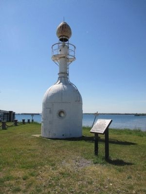
| 201 ► New York, Erie County, Buffalo, First Ward — Buffalo Lightship — |
| Near Fuhrmann Boulevard, 1.3 miles north of The Skyway (New York State Route 5). | |||
| 202 ► New York, Erie County, Buffalo, First Ward — Development of the Inner Harbor — The Industrial Heritage Trail — |
| On Fuhrmann Boulevard at South Michigan Avenue, on the left when traveling north on Fuhrmann Boulevard. | |||
| 203 ► New York, Erie County, Buffalo, First Ward — Fireproof Grain Elevators / Concrete Grain Elevators — The Industrial Heritage Trail — |
| On Fuhrmann Boulevard, 0.2 miles south of The Skyway (New York State Route 5), on the left when traveling north. | |||
| 204 ► New York, Erie County, Buffalo, First Ward — History of Times Beach — The Industrial Heritage Trail — |
| On Fuhrmann Boulevard, 1 mile north of The Skyway (New York State Route 5), on the left when traveling north. | |||
| 205 ► New York, Erie County, Buffalo, First Ward — Lighthouse Point Park — |
| On Fuhrmann Boulevard, 1.2 miles north of The Skyway (New York State Route 5), on the right when traveling north. | |||
| 206 ► New York, Erie County, Buffalo, First Ward — Penobscot-Morania Collision — |
| Near Fuhrmann Boulevard near The Skyway (New York State Route 5). | |||
| 207 ► New York, Erie County, Buffalo, First Ward — The American Elevator — The Industrial Heritage Trail — |
| On Fuhrmann Boulevard, 0.2 miles north of Ohio Street, on the right when traveling south. | |||
| 208 ► New York, Erie County, Buffalo, First Ward — The Cargill Superior Elevator — The Industrial Heritage Trail — |
| On Fuhrmann Boulevard, 0.2 miles north of Ohio Street, on the left when traveling north. | |||
| 209 ► New York, Erie County, Buffalo, First Ward — The Coast Guard — |
| Near Fuhrmann Boulevard, 1.3 miles north of The Skyway (New York State Route 5). | |||
| 210 ► New York, Erie County, Buffalo, First Ward — The Concrete Central Elevator — The Industrial Heritage Trail — |
| On Fuhrmann Boulevard, 0.2 miles north of Ohio Street, on the right when traveling south. | |||
| 211 ► New York, Erie County, Buffalo, First Ward — The Early Grain Trade / Influence of the Erie Canal — The Industrial Heritage Trail — |
| On Fuhrmann Boulevard, 0.2 miles south of The Skyway (New York State Route 5), on the left when traveling north. | |||
| 212 ► New York, Erie County, Buffalo, First Ward — The Electric Elevator Annex — The Industrial Heritage Trail — |
| On Fuhrmann Boulevard, 0.2 miles north of Ohio Street, on the left when traveling north. | |||
| 213 ► New York, Erie County, Buffalo, First Ward — The Engineers of the Grain Elevators — The Industrial Heritage Trail — |
| On Fuhrmann Boulevard, 0.2 miles south of The Skyway (New York State Route 5), on the right when traveling south. | |||
| 214 ► New York, Erie County, Buffalo, First Ward — The First Grain Elevator / Early Grain Elevators — The Industrial Heritage Trail — |
| On Fuhrmann Boulevard, 0.2 miles south of The Skyway (New York State Route 5), on the right when traveling south. | |||
| 215 ► New York, Erie County, Buffalo, First Ward — The Grain Elevators — The Industrial Heritage Trail — |
| On Fuhrmann Boulevard, 0.2 miles south of The Skyway (New York State Route 5), on the right when traveling south. | |||
| 216 ► New York, Erie County, Buffalo, First Ward — The Lake and Rail Elevator — The Industrial Heritage Trail — |
| On Fuhrmann Boulevard, 0.2 miles north of Ohio Street, on the left when traveling north. | |||
| 217 ► New York, Erie County, Buffalo, First Ward — The Lighthouse Service — |
| Near Fuhrmann Boulevard, 1.3 miles north of The Skyway (New York State Route 5). | |||
| 218 ► New York, Erie County, Buffalo, First Ward — The Marine "A" Elevator — The Industrial Heritage Trail — |
| On Fuhrmann Boulevard, 0.2 miles north of Ohio Street, on the left when traveling north. | |||
| 219 ► New York, Erie County, Buffalo, First Ward — The Perot Malting Elevator — The Industrial Heritage Trail — |
| On Fuhrmann Boulevard, 0.2 miles north of Ohio Street, on the left when traveling north. | |||
| 220 ► New York, Erie County, Buffalo, First Ward — The Saskatchewan Pool Elevator — The Industrial Heritage Trail — |
| On Fuhrmann Boulevard, 0.2 miles north of Ohio Street, on the right when traveling south. | |||
| 221 ► New York, Erie County, Buffalo, First Ward — The Spencer Kellogg Elevator — The Industrial Heritage Trail — |
| On Fuhrmann Boulevard, 0.2 miles north of Ohio Street, on the right when traveling south. | |||
| 222 ► New York, Erie County, Buffalo, First Ward — The Standard Elevator — The Industrial Heritage Trail — |
| On Fuhrmann Boulevard, 0.2 miles north of Ohio Street, on the right when traveling south. | |||
| 223 ► New York, Erie County, Buffalo, First Ward — The Wheeler / GLF Elevator — |
| On Fuhrmann Boulevard, 0.2 miles north of Ohio Street, on the left when traveling north. | |||
| 224 ► New York, Erie County, Buffalo, Park Meadow — Highlights of Buffalo History — Buffalo and Erie County Historical Society — Cultural Heritage — |
| On Museum Court at Nottingham Terrace, on the left when traveling south on Museum Court. | |||
| 225 ► New York, Erie County, Buffalo, Riverside — Hunting and Fishing off the Porch — |
| On Niagara Street (Route 266) at Collaton Street, on the right when traveling south on Niagara Street. | |||
| 226 ► New York, Erie County, Buffalo, Riverside — Niagara River Corridor / Avian Walk — |
| On Aqua Lane, 0.1 miles Black Rock Harbor, in the median. | |||
| 227 ► New York, Erie County, Buffalo, South Park — Bethlehem Steel in Lackawanna — The Industrial Heritage Trail — Part 1: The Move From Scranton — |
| On Fuhrmann Boulevard, 0.2 miles south of Ohio Street, on the right when traveling south. | |||
| 228 ► New York, Erie County, Buffalo, South Park — Development of the Outer Harbor — The Industrial Heritage Trail — |
| On Fuhrmann Boulevard at Tifft Street, on the right when traveling south on Fuhrmann Boulevard. | |||
| 229 ► New York, Erie County, Buffalo, South Park — Early Lake Erie Water Craft — The Industrial Heritage Trail — |
| On Fuhrmann Boulevard, 0.2 miles south of Tifft Street, on the right when traveling south. | |||
| 230 ► New York, Erie County, Buffalo, South Park — Improvements in Ship Design — The Industrial Heritage Trail — |
| On Fuhrmann Boulevard, 0.2 miles south of Ohio Street, on the left when traveling north. | |||
| 231 ► New York, Erie County, Buffalo, South Park — The Great Lakes — The Industrial Heritage Trail — |
| On Fuhrmann Boulevard, 0.2 miles south of Tifft Street, on the left when traveling north. | |||
| 232 ► New York, Erie County, Buffalo, South Park — The Lehigh Portland Cement Company — The Industrial Heritage Trail — |
| On Fuhrmann Boulevard, 0.2 miles south of Ohio Street, on the left when traveling north. | |||
| 233 ► New York, Erie County, Buffalo, South Park — The Union Ship Canal — The Industrial Heritage Trail — |
| On Fuhrmann Boulevard, 0.2 miles south of Ohio Street, on the right when traveling south. | |||
| 234 ► New York, Erie County, Buffalo, Waterfront — "Rust Bucket" — |
| Near Marine Drive east of Erie Road, on the right when traveling east. | |||
| 235 ► New York, Erie County, Buffalo, Waterfront — A Changing Waterfront — |
| On Marine Drive at Commercial Street, on the right when traveling east on Marine Drive. | |||
| 236 ► New York, Erie County, Buffalo, Waterfront — Birthplace of the Grain Elevator |
| On Erie Street west of Marine Drive, on the left when traveling west. Reported missing. | |||
| 237 ► New York, Erie County, Buffalo, Waterfront — Buffalo - A Network of Canals — Sail Lofts, Stables, Grain Elevators, Brothels, Saloons — |
| On Lloyd Street at Marine Drive, on the right when traveling south on Lloyd Street. | |||
| 238 ► New York, Erie County, Buffalo, Waterfront — Buffalo - An Industrial Powerhouse — Tanneries, Clothiers, Piano Makers, Saddlers and Breweries — |
| On Lloyd Street at Marine Drive, on the right when traveling south on Lloyd Street. | |||
| 239 ► New York, Erie County, Buffalo, Waterfront — Buffalo - Queen City of the Lakes — Erie Canalway National Heritage Corridor — |
| Near Marine Drive at Commercial Street. | |||
| 240 ► New York, Erie County, Buffalo, Waterfront — Buffalo Riverfront Historical Eras to 1930 — |
| On Marine Drive at Commercial Street, on the left when traveling west on Marine Drive. | |||
| 241 ► New York, Erie County, Buffalo, Waterfront — Buffalo's Birthplace — Where the Erie Canal Joins the Commercial Slip — |
| On Commercial Street at Perry Boulevard, on the left when traveling south on Commercial Street. | |||
| 242 ► New York, Erie County, Buffalo, Waterfront — Canal and Harbor — Transforming Buffalo — |
| Near Marine Drive, 0.1 miles north of Lloyd Street, on the right when traveling west. | |||
| 243 ► New York, Erie County, Buffalo, Waterfront — Coit and Townsend’s “Red” Warehouse — Buffalo’s Earliest Wealth — |
| On Marina Park South at Commercial Street, on the left when traveling west on Marina Park South. | |||
| 244 ► New York, Erie County, Buffalo, Waterfront — Erie Canalway National Heritage Corridor — |
| On Marine Drive at Commercial Street, on the right when traveling east on Marine Drive. | |||
| 245 ► New York, Erie County, Buffalo, Waterfront — Harboring Hopes — |
| On Lloyd Street at Prime Street, on the left when traveling east on Lloyd Street. | |||
| 246 ► New York, Erie County, Buffalo, Waterfront — Historic Lake Erie — |
| On Erie Street, 0.5 miles west of Marine Drive, on the right when traveling south. | |||
| 247 ► New York, Erie County, Buffalo, Waterfront — Poland’s Contribution in the Second World War, 1939 - 1945 — |
| Near Marine Drive east of Erie Road when traveling east. | |||
| 248 ► New York, Erie County, Buffalo, Waterfront — PTF-17 — Buffalo, Erie County Military & Naval Park — |
| Near Marine Drive south of Marine Drive. | |||
| 249 ► New York, Erie County, Buffalo, Waterfront — Rebirth & Renewal — |
| On Prime Street at Lloyd Street, on the left when traveling north on Prime Street. | |||
| 250 ► New York, Erie County, Buffalo, Waterfront — The Big Picture — |
| On Lloyd Street at Marine Drive, on the right when traveling south on Lloyd Street. | |||
| 251 ► New York, Erie County, Buffalo, Waterfront — The Erie Canal / Two Waterfronts — |
| On Prime Street at Lloyd Street, on the left when traveling north on Prime Street. | |||
| 252 ► New York, Erie County, Buffalo, Waterfront — The Grand Canal — |
| On Marine Drive at Commercial Street, on the left when traveling west on Marine Drive. | |||
| 253 ► New York, Erie County, Buffalo, Waterfront — The Immigrant Steps — Building Buffalo — |
| Near Commercial Street at Perry Boulevard, on the right when traveling north. | |||
| 254 ► New York, Erie County, Buffalo, Waterfront — The Industrial Heritage Trail — Monuments to the Movement of Grain — Maritime Heritage — |
| Near Erie Street, 0.1 miles west of Marine Drive. | |||
| 255 ► New York, Erie County, Buffalo, Waterfront — The Ruins at Canalside — Drinking in 19th Century Buffalo — |
| On Lloyd Street, 0.1 miles north of Prime Street, on the right when traveling south. | |||
| 256 ► New York, Erie County, Buffalo, Waterfront — USS Grenadier (SS210) — Lost in Action April 22, 1943 — |
| Near Marine Drive, 0.2 miles west of Erie Street. | |||
| 257 ► New York, Erie County, Buffalo, Waterfront — USS The Sullivans (DD-537) — Buffalo, Erie County Military & Naval Park — |
| Near Marine Drive west of Buffalo Skyway (New York State Route 5). | |||
| 258 ► New York, Erie County, Buffalo, Waterfront — USS Boston SSN703 — |
| On Marine Drive at Marine Drive, on the left when traveling west on Marine Drive. | |||
| 259 ► New York, Erie County, Buffalo, Waterfront — Waterfront Sites — From the LaSalle Park Gateway — |
| Near Amvets Drive at Porter Avenue, on the right when traveling south. | |||
| 260 ► New York, Erie County, Buffalo, Waterfront — Wedding of the Waters — The Completion of the Erie Canal — |
| Near Marine Drive at Pearl Street. | |||
| 261 ► New York, Erie County, Buffalo, Waterfront — William Wells Brown — Anti-Slavery Activist and Writer — |
| Near Marine Drive at Pearl Street. | |||
| 262 ► New York, Erie County, Clarence — Niagara Frontier — Historic New York — |
| Near Governor Thomas E. Dewey Thruway (Interstate 90 at milepost 412), 10.6 miles west of Alleghany Road (New York State Route 77), on the right when traveling west. | |||
| 263 ► New York, Erie County, Grand Island — Strawberry Island — Past to Present — |
| On Park Road Loop at Area 3, on the right when traveling east. | |||
| 264 ► New York, Erie County, Grand Island — Strawberry Island — Don't Be Fooled By Its Size — |
| On Park Road Loop at Area 3, on the right when traveling east. | |||
| 265 ► New York, Erie County, Hamburg — Lake Erie — Sailing Through Time — Maritime Heritage — |
| On Lake Shore Road (New York State Route 5) 0.1 miles west of Lakewood Avenue, on the right when traveling west. | |||
| 266 ► New York, Erie County, Hamburg — Lighthouse LV82 — Guardian of the Buffalo Harbor — |
| On New York State Route 5 at Big Tree Road, on the right when traveling west on State Route 5. | |||
| 267 ► New York, Erie County, Tonawanda — City of Tonawanda — A Community Built Around Lumber — |
| On East Main Street at Longs Avenue, on the right when traveling west on East Main Street. | |||
| 268 ► New York, Erie County, Tonawanda — Engineering the Erie Canal — |
| Near Niagara Street (New York State Route 266) 0.1 miles north of Gibson Street. | |||
| 269 ► New York, Erie County, Tonawanda — Erie Canal Site — |
| 270 ► New York, Erie County, Tonawanda — Gastown — Erie Canalway Trail — |
| On East Niagara Street at East Avenue, on the right when traveling west on East Niagara Street. | |||
| 271 ► New York, Erie County, Tonawanda — Gateway to the West — |
| On Main Street at Young Street when traveling north on Main Street. | |||
| 272 ► New York, Erie County, Tonawanda — Grand Island Ferry — |
| Near River Road (New York State Route 266) 0.1 miles north of Gibson Street. | |||
| 273 ► New York, Erie County, Tonawanda — Great Ships of the Niagara — Niagara River Greenway — |
| Near Niagara Street (New York State Route 266) 0.1 miles north of Franklin Street. | |||
| 274 ► New York, Erie County, Tonawanda — Lumber Capital — |
| On Young Street at Main Street, on the right when traveling west on Young Street. | |||
| 275 ► New York, Erie County, Tonawanda — The Dam — |
| On Young Street at Main Street, on the right on Young Street. | |||
| 276 ► New York, Erie County, Tonawanda — The Long Homestead — |
| Near East Niagara Street, 0.1 miles west of Fillmore Avenue. | |||
| 277 ► New York, Erie County, Tonawanda — The People — Erie Canalway Trail — |
| On East Niagara Street at Longs Avenue, on the right when traveling west on East Niagara Street. | |||
| 278 ► New York, Erie County, Tonawanda — The Railroad — |
| On Young Street at Main Street, on the left when traveling east on Young Street. | |||
| 279 ► New York, Erie County, Tonawanda — Westward to Buffalo — Niagara River Greenway — |
| Near Niagara Street (New York State Route 266) 0.2 miles west of Veterans Road. | |||
| 280 ► New York, Essex County, Crown Point — Samuel Champlain — |
| Near Adirondack Road. | |||
| 281 ► New York, Essex County, Ironville — 3 — Penfield Pond — Station 3 — |
| Near Creek Road (County Route 2) 0.1 miles west of Whitehead Road, on the left when traveling west. | |||
| 282 ► New York, Essex County, Port Henry — A Busy Iron Port — |
| On Park Place east of Main Street (New York State Route 9N/22), on the left when traveling east. | |||
| 283 ► New York, Essex County, Port Henry — A Busy Iron Port — |
| On Park Place east of Main Street (New York State Route 9N/22), on the right when traveling east. | |||
| 284 ► New York, Essex County, Port Henry — Daisy Godfrey — 1889 - 1982 — |
| 285 ► New York, Essex County, Port Henry — Industrial Shoreline — |
| On Park Place east of Main Street (New York State Route 9N/22), on the left when traveling east. | |||
| 286 ► New York, Essex County, Port Henry — Shore Line — |
| On Main Street (New York State Route 9N/22), on the right when traveling north. | |||
| 287 ► New York, Essex County, Port Henry — Teamsters, Dock Wallopers and Child Captains — |
| 288 ► New York, Essex County, Port Henry — The 1929 Lake Champlain Bridge — |
| 289 ► New York, Essex County, Port Henry — The 1929 Lake Champlain Bridge — |
| On Park Place east of Main Street (New York State Route 9N/22), on the left when traveling east. | |||
| 290 ► New York, Essex County, Port Henry — The 2011 Lake Champlain Bridge — |
| 291 ► New York, Essex County, Putnam, Putnam Station — Lake George — |
| On Black Point Road at Tiroga Beach Road, on the right when traveling south on Black Point Road. | |||
| 292 ► New York, Essex County, Tahawus — Transportation — |
| On Upper Works Road (County Route 25) 9.8 miles Blue Ridge Road, on the left when traveling north. | |||
| 293 ► New York, Essex County, Ticonderoga — 10 — "C-Dam" — LaChute Riverwalk — |
| Near Lake George Avenue south of Stanton Street, on the left when traveling south. | |||
| 294 ► New York, Essex County, Ticonderoga — 2 — A Way to the World — |
| Near Montcalm Street (State Highway 74) 0.2 miles west of Mountain Road (State Highway 22), on the right when traveling west. | |||
| 295 ► New York, Essex County, Ticonderoga — 6 — Anatomy of the River — LaChute Riverwalk — |
| Near Adirondack Park, 0.1 miles east of Carnegie Place, on the left when traveling east. | |||
| 296 ► New York, Essex County, Ticonderoga — 4 — Crossroads of a Community — LaChute Riverwalk — |
| Near Adirondack Park north of Champlain Avenue, on the left when traveling east. | |||
| 297 ► New York, Essex County, Ticonderoga — 12 — Historic Valley — LaChute Riverwalk — |
| On Lake George Avenue, 0.1 miles north of Alexandria Avenue, on the right when traveling south. | |||
| 298 ► New York, Essex County, Ticonderoga — Historic Waterways — |
| Near Sandy Redoubt. | |||
| 299 ► New York, Essex County, Ticonderoga — Lakes to Locks Passage — The Great Northeast Journey — Lake Champlain Region — |
| On Montcalm Street at Tower Avenue, on the right when traveling west on Montcalm Street. | |||
| 300 ► New York, Essex County, Ticonderoga — Lakes to Locks Passage — The Great Northeast Journey — Lake Champlain Region — |
| On Montcalm Street at Tower Avenue, on the right when traveling west on Montcalm Street. | |||
1224 entries matched your criteria. Entries 201 through 300 are listed above. ⊲ Previous 100 — Next 100 ⊳