On East Center Street at North Idaho Street, on the right when traveling north on East Center Street.
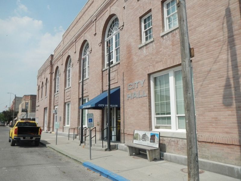
The City Hall building was built in 1914. The ground where the building sits was purchased from David Robb for $4,450. It was designed by renowned architect Fred R. Willson and built by contractor William Reed. Construction began in April 1914 and . . . — — Map (db m180694) HM
On East Center Street near North Idaho Street, on the left when traveling south.
The four buildings that make up this small historic district show the growth of Dillon’s city government. Buildings include ones constructed in the Progressive Era, the New Deal, and the 1960s, when the city built a shelter for one of its water . . . — — Map (db m180751) HM
On South Pacific Street at East Clark Street, on the right when traveling west on South Pacific Street.
The Martin Barrett House, built in 1912, was the in-town retirement home of prominent pioneer rancher, politician and philanthropist Martin Barrett and his wife Alice. One of the finest examples of early-twentieth-century architecture in Dillon, the . . . — — Map (db m209432) HM
On North Custer Avenue near Fifth Street West when traveling north.
Building contractor Ernest Adler constructed these attached, flat roofed storefronts between 1914 and 1920. A German immigrant, Adler was one of Hardin’s most prolific builders. Situated on the edge of the business district, the one-story brick . . . — — Map (db m189252) HM
On East Railway Street near North Central Avenue, on the right when traveling east.
Hardin’s first railroad depot was moved from Fort Custer after being cut into small sections and transported by train over the Big Horn Bridge. That depot was expanded in 1909, but was deemed inadequate after the homestead boom dramatically . . . — — Map (db m189370) HM
On West Third Street (Old U.S. Highway 87) near North Chouteau Avenue, on the left when traveling west.
As Hardin’s residential neighborhoods began to take shape during the 1910s and 1920s, the new Craftsman style emerged as a favored design. Its popularity was partly due to the ready availability and low cost of the machine-made, mass-produced . . . — — Map (db m189330) HM
On North Crawford Avenue near West 6th Street, on the left when traveling north.
In 1900, John Svaren left his home in Bergen, Norway, to join family in South Dakota. There he learned English before homesteading to North Dakota in 1909. With his bride, Betsy, Svaren arrived in Hardin in 1917 to build a home. He applied his . . . — — Map (db m189331) HM
On North Central Avenue at 2nd Street West, on the left on North Central Avenue.
German immigrant Anton Becker had great faith in Hardin’s future. Becker bought this lot on May 30, 1907, the day town lots went on sale. He soon constructed a two-story brick building, in front of which he installed Hardin’s first cement sidewalk. . . . — — Map (db m189367) HM
On North Central Avenue near 2nd Street West, on the left when traveling north.
The elaborate corbelling on the front façade and the parapet above the transom evoke the glory days of this building, which long provided recreation for Hardin residents. German immigrant Anton Becker, owner of the hotel next door, constructed the . . . — — Map (db m189365) HM
On West 4th Street near North Central Avenue, on the left when traveling west.
Montana created twenty-six counties during its 1910 county-splitting craze. Among them was Big Horn County, carved from portions of Yellowstone and Rosebud Counties in 1913. Private entrepreneurs constructed the new county’s first courthouses. In . . . — — Map (db m189332) HM
On North Central Avenue near Second Street West, on the left when traveling north.
Charles and Rushann Schneider built this two-story brick business block in 1910. Anticipating the arrival of electricity by four years, the Schneiders had their building wired during its construction. The exterior’s relative simplicity reflects the . . . — — Map (db m189363) HM
On Main Street (State Highway 308) at South 2nd Street, on the right when traveling west on Main Street.
A coal-mining town established in 1905, Bearcreek developed quickly, and after just one year the town boasted telephones, city water, and electric streetlights. Bert Vaill, a cashier with the Carbon County Bank of Red Lodge, purchased this lot from . . . — — Map (db m190148) HM
On State Highway 308, 0.1 miles west of Scotch Coulee Road, on the right when traveling west.
Thirty-nine corrugated metal structures mark the site of the Smith Mine, a ghostly reminder of a once vibrant mining district. The Montana Coal and Iron Company (MCI) began developing the Smith Mine in earnest after the arrival of the Montana, . . . — — Map (db m190143) HM
On North E Street at East Broadway Avenue, on the left when traveling east on North E Street.
known as the Pillsbury House
Built 1907
has been placed on the
National Register
Of Historic Places
by the United States
Department of the Interior — — Map (db m167009) HM
On South 1st Street at U.S. 212, on the left when traveling north on South 1st Street.
“Chief shepherd” Walter Jordan and “singing evangelist” Lucile Park preached to a packed house at an October 1908 revival meeting, held above the meat market on Joliet’s Main Street. Forty-five charter members joined together to found the Joliet . . . — — Map (db m190744) HM
On Main Street at East Central Avenue, on the left when traveling north on Main Street.
The Bank of Joliet opened in 1904 and began planning construction of this stately one-story building soon after. By the time the $8,000 building was completed in 1907, the bank had new owners and a new name. Built on Joliet’s most visible corner, . . . — — Map (db m190745) HM
On Hauser Avenue North near 5th Street West, on the right.
The manager of the Red Lodge Brewery, Paul Lehrkind, purchased this lot in 1920, likely with the intent of building a home. However, despite efforts to survive Prohibition by manufacturing the “near beer” Bud-O (“Always on Top”), Lehrkind was forced . . . — — Map (db m190277) HM
On Hauser Avenue North near 7th Street West, on the left when traveling north.
Over a quarter of the houses in the elite “Hi Bug” neighborhood were built between 1900 and 1901, including this one-and-one-half-story home, erected as a real estate investment by Red Lodge merchant Walter R. Hall and his wife Louisa. After leasing . . . — — Map (db m190244) HM
On Hauser Avenue North near 3rd Street West (State Highway 78), on the left.
Forty-five guests enjoyed a sumptuous dinner and housewarming at the home of John and Alphia Chapman on November 12, 1903. Begun in 1902, completion of the residence was delayed when contractor Walter S. Smith suffered a serious fall from the porch . . . — — Map (db m190278) HM
On 3rd Street West near Airport Road, on the left when traveling west.
A natural springs and pond provided ice and water for a brewery established here in the early 1890s. In 1894, arson destroyed the ice house and brewery buildings, but a small, one-room log residence escaped the blaze. Dan Davis purchased the . . . — — Map (db m190562) HM
On Hauser Avenue North at 5th Street West, on the left when traveling north on Hauser Avenue North.
Architect Seth Hunneywell designed and built this Colonial Revival two-and-one-half-story home for Alfred and Ruth Flager, who lived here from 1902 to 1911. Costing approximately $3,500 to build and boasting “all the modern conveniences,” its “eight . . . — — Map (db m190274) HM
On 6th Street West near Word Avenue North, on the right when traveling west.
Prominent lumber merchant C. C. Bowlen purchased this lot in 1901. Two years later, when attorney George Pierson decided to build a larger home, Bowlen purchased Pierson’s front-gable residence and moved it a block south to this location. . . . — — Map (db m190559) HM
On U.S. 212 near Two Mile Bridge Road, on the left when traveling north.
Finnish immigrant Ephraim Kent settled in Red Lodge in the early 1900s to work in the coal mines while his wife, Fiina, began a small dairy business. It was a family venture from the start, with all the children pitching in to deliver raw milk in . . . — — Map (db m190567) HM
On Broadway Avenue South (U.S. 212) near 11th Street West, on the left when traveling north.
Early Red Lodge businessmen James Blackburn and Dominic Marino jointly built this fine two-story commercial building circa 1905 to house a mercantile business. A series of saloons later occupied the ground floor. An upstairs boarding house, first . . . — — Map (db m190220) HM
On 7th Street West at Word Avenue North, on the right when traveling west on 7th Street West.
A four-square plan, tapered porch pillars, and flared overhanging eaves reflect the Craftsman style influence that affords this distinctive home a more modern appearance than its contemporary neighbors. Decorative cresting and leaded glass add . . . — — Map (db m190440) HM
On Hauser Avenue North at 6th Street West, on the left when traveling north on Hauser Avenue North.
Rocky Fork Town and Electric Company sold this lot and the one next door to F. P. Musser for $84 in 1896. Immediate resale to real estate agent T. P. McDonald for $177 netted Musser a handsome profit. This four-square cottage was either moved or . . . — — Map (db m190247) HM
On Hauser Avenue North near 5th Street West, on the right when traveling north.
The sloping roof of this one-and-one-half-story house once shaded an open porch. The curved roofline and shed dormer add Craftsman style elegance to the home, constructed on a double lot after 1907. The interior also reflected Craftsman ideals with . . . — — Map (db m190276) HM
On Broadway Avenue South (U.S. 212) near 12th Street East, on the right when traveling north.
These two turn-of-the-twentieth-century wood-frame commercial buildings with a tiny shop sandwiched in between today share one façade. In 1900, Biagio Sconfienza opened a bakery in the one-story building. In 1903, as the business prospered, Biagio . . . — — Map (db m190225) HM
On Word Avenue North at Adams Avenue North, on the left when traveling north on Word Avenue North.
One of nine remaining homes on Nutting Row, this foursquare cottage features a hip-roofed main block with ornate dormers with shingles in an imbricate pattern. The design and plan of this 1907 home reflects William B. Nutting’s role in the . . . — — Map (db m190448) HM
On Hauser Avenue North at 3rd Street West, on the left when traveling north on Hauser Avenue North.
Irish immigrant Daniel G. O’Shea arrived in Carbon in 1887. The eager eighteen year old took a position with the Rocky Fork Coal Company, serving as paymaster and bookkeeper until 1899 when he was appointed manager. He resigned from RFCC in 1903 to . . . — — Map (db m190438) HM
On Hauser Avenue North near 7th Street West, on the left when traveling north.
“Coziness” was the watchword of progressive builders in the early twentieth century. Small, well-designed houses proliferated after 1900 in part to compensate for the expense of such modern conveniences as indoor plumbing. Plans for . . . — — Map (db m190227) HM
On Hauser Avenue North near 6th Street West, on the left when traveling north.
Michigan-born attorney George Pierson and his wife Loretta moved to Red Lodge in 1894. Soon thereafter they purchased this lot, where they lived in a one-story cottage. After the Piersons decided to build this “Free Classic” Queen Anne style . . . — — Map (db m190248) HM
On 2nd Street East at Haggin Avenue, on the right when traveling west on 2nd Street East.
Pure Rock Creek water and a ready market of thirsty coal miners struck Bozeman beer baron Julius Lehrkind as a recipe for success. With nephews Fred and Paul, Julius incorporated the Red Lodge Brewing Company in 1910, hiring the prominent . . . — — Map (db m190564) HM
Near State Highway 78, 0 miles north of Lower Continental Drive, on the left when traveling north.
The Consolidated Mausoleum Company made the case for constructing a communal mausoleum in a full-page newspaper advertisement in 1921. “The present high state of civilization demands for the masses a more humane and sanitary method of taking care of . . . — — Map (db m190570) HM
On Word Avenue North at 7th Street West, on the left when traveling north on Word Avenue North.
Prominent Red Lodge businessman William B. Nutting subdivided this northwestern neighborhood as the Nutting Addition circa 1899. Beginning in 1900 with this home, he built five cottages north of his own residence that became known as Nutting Row. J. . . . — — Map (db m190443) HM
On Hauser Avenue North at 5th Street West, on the right when traveling north on Hauser Avenue North.
A steep-roofed gable-front cottage with a wraparound porch stood on this lot by 1901. Sometime before 1907 Rose Robbins—who owned the one-and-one-half-story home along with many other lots in the neighborhood—expanded the residence, adding a rear . . . — — Map (db m190275) HM
On Broadway Avenue South near 13th Street East, on the right when traveling north.
Original rusticated and ashlar concrete blocks and the 1935 ROMAN marquee distinguish the façade of this early movie theater. Austrian immigrant Steve Roman built the theater in 1917. One of fourteen sons, nineteen-year-old Roman came to Red Lodge . . . — — Map (db m190222) HM
On Hauser Avenue North near 5th Street West, on the left when traveling north.
Real estate speculation abounded after the Northern Pacific Railroad constructed a branch line to Red Lodge to take advantage of the area's rich coal deposits. In 1891 Nathan Smethurst purchased this lot for $36, selling it for a profit the same . . . — — Map (db m190249) HM
On Hauser Avenue North near 7th Street West, on the left when traveling north.
A prestigious corner site contributes much to the elegance of this Queen Anne style cottage, built by rancher and businessman Louis Sichler in 1902. The steep and asymmetrical roofline, projecting gables, and two-storied bay epitomize the Queen Anne . . . — — Map (db m190245) HM
On Hauser Avenue North near 3rd Street West, on the right when traveling north.
W. A. Talmage arrived in Red Lodge in 1888 to manage a branch of a Billings mercantile. By 1894, the ambitious businessman owned his own large hardware and farm implements store on Billings Avenue. Undoubtedly, his business connections helped . . . — — Map (db m190436) HM
On Hauser Avenue North at 6th Street West, on the left when traveling north on Hauser Avenue North.
According to an oral tradition handed down in the Crockett family, this gable-front cottage was moved here from “Old Town.” It was remodeled circa 1901 when it is first recorded on this lot. At that time, prominent merchant W. A. Talmage owned the . . . — — Map (db m190246) HM
On Broadway Avenue South near 12th Street West, on the left when traveling north.
This fine example of masonry architecture, with its unusually preserved storefront and recessed entry, appears almost as it did in 1900 when Walter Hall opened his first-floor grocery. Sandstone banding, corbelled arches, and original stained glass . . . — — Map (db m190221) HM
On Russell Drive South near Central Avenue East, on the right when traveling north.
The son of a wealthy St. Louis family, Charles M. “Charlie” Russell longed for western adventure. In 1880, at fifteen, he convinced his parents to let him visit Montana. He never looked back. For over ten years, he worked as a night herder during . . . — — Map (db m245460) HM
On Main Street (State Highway 13) just south of 2nd Avenue, on the right when traveling south.
The settlement of Old Scobey relocated here from the Poplar River flats to greet the approaching Great Northern Railway branch line in 1913. By the time the first train arrived on Thanksgiving Day, the two-story Commercial Hotel—today the south . . . — — Map (db m202833) HM
On West Bell Street near North Merrill Avenue, on the left when traveling south.
Contractor John Holm constructed this small two-story building for the Dion family in 1929 after he had remodeled the Dion Block on one side and built the J.C. Penney Building on the other. This final addition to the five-building Dion Block shares . . . — — Map (db m163465) HM
On North Douglas Street at West Bell Street when traveling north on North Douglas Street.
Rancher and banker Charles Krug came west from Ohio in 1878, searching for opportunity and a climate to relieve his sister Emma’s asthma. In 1881, he and Emma settled in Glendive where she was a seamstress and he worked for the railroad. Krug built . . . — — Map (db m163564) HM
On West Bell Street near North Merrill Avenue, on the left when traveling west.
After the death of Glendive pioneer Henry Dion in 1920, his widow and children contracted with John Holm to construct this commercial building according to the specifications of the J.C. Penney Company. Built in 1929, the architecture is typical of . . . — — Map (db m163560) HM
On East Park Avenue (State Highway 1) near Cherry Street, on the left when traveling east.
Backed by the powerful San Francisco syndicate of Hearst, Haggin and Tevis, Marcus Daly built the world’s largest smelter (combined upper and lower works) on Warm Springs Creek between 1883 and 1889. Along with the smelters, Daly envisioned a . . . — — Map (db m183523) HM
On East Commercial Avenue near Cherry Street, on the left when traveling west.
In 1888, one- and two-story, wood-frame commercial buildings filled almost the entire block. Constructed circa 1890 on the block’s last vacant lot, this store was home to McKinnon and MacKay’s grocery. An expanse of brick with three recessed panels . . . — — Map (db m205642) HM
On West Third Street near Locust Street, on the left when traveling west.
Anaconda’s business leaders located on the town’s west side beginning in the 1890s. The idyllic neighborhood was far from the smelter and close to commerce on Main and Park streets. Tree-lined sidewalks with street lamps, a large public park, and a . . . — — Map (db m205590) HM
On East 3rd Street at Cedar Street, on the left when traveling west on East 3rd Street.
A fleet of twelve hundred masons and carpenters flocked to Warm Springs Creek in 1883 to build Marcus Daly’s Anaconda Company smelter. Daly hired Welsh masonry contractor John “Jack” W. Cornelius to oversee the construction process for his enormous . . . — — Map (db m205726) HM
On Main Street at West 5th Street, on the left when traveling north on Main Street.
Intricate ornamental cresting caps the dome on the octagonal tower of this handsome residence. Its eclectic architecture combines elements of the Queen Anne and French Second Empire styles. A partial Mansard roof at the northeast corner and a front . . . — — Map (db m205803) HM
On Chestnut Street near East 5th Street, on the right when traveling north.
Rapidly increasing demand for copper ore in the 1890s brought an influx of more than 5,000 new residents to the Smelter City between 1890 and 1900. To house them all, a fleet of carpenters built hundreds of cottages and multi-family units. This . . . — — Map (db m205713) HM
On East Third Street at Ash Street, on the left when traveling west on East Third Street.
Rapidly increasing demand for copper ore in the 1890s brought an influx of more than 5,000 new residents to the Smelter City between 1890 and 1900. To house them all, a fleet of carpenters built hundreds of cottages and multi-family units. This . . . — — Map (db m205708) HM
On 401 East Commercial Avenue at Cedar Street, on the left when traveling west on 401 East Commercial Avenue.
Copper magnate Marcus Daly had great expectations for Anaconda when the town was platted in 1883, hoping one day the town would become Montana’s capital. It was with that goal in mind that plans for a magnificent city hall were conceived. Architects . . . — — Map (db m205641) HM
On West Commercial Avenue near Locust Street, on the right when traveling west.
Tired of exorbitant freight rates, copper king Marcus Daly decided to build his own railroad in 1892 to haul ore from the Butte mines to his Anaconda smelter. Daly envisioned the Butte, Anaconda and Pacific Railway extending to the Pacific Ocean. . . . — — Map (db m205592) HM
On East Commercial Avenue near Cherry Street, on the left when traveling west.
Anaconda workers unionized early to promote their interests. The United Brotherhood of Carpenters and Joiners Local 88 formed in Anaconda in 1889 with nine charter members. Its original bylaws committed the union to working “to replace the present . . . — — Map (db m205647) HM
On East Commercial Avenue at Cherry Street on East Commercial Avenue.
This building began as a one-story, wood-frame grocery store on Main Street in 1883. In 1885, owner David Cohen Sr. sided it with brick veneer, giving it a more permanent appearance. Soon after, a fire broke out, destroying nearly everything on the . . . — — Map (db m205706) HM
On Main Street at West Commercial Avenue, on the right when traveling north on Main Street.
A heavy metal cornice, cast iron columns, and a metal frieze still embellish this building, constructed in 1895. Two cast-iron oriel windows once also graced the upper story. The Anaconda Company’s foundry produced the decorative metal front, a . . . — — Map (db m180973) HM
On Locust Street at West 6th Street, on the left on Locust Street.
Anaconda’s elite began to build homes on the West Side in the 1890s, and this Queen Anne style mansion was one of the first to grace upper Locust Street. Built in 1894 for Fred Clark, librarian at the Hearst Free Public Library, the elegant . . . — — Map (db m205884) HM
On West 3rd Street near Poplar Street, on the left when traveling west.
New residents flooded the housing market as Anaconda’s smelter works expanded into the twentieth century and the town began to outgrow its original perimeters. The City Council approved several new additions including this area, annexed as the First . . . — — Map (db m205588) HM
On Main Street at East 4th Street, on the left when traveling south on Main Street.
Phoebe Hearst, wife of wealthy California senator George Hearst, had a special relationship with Anaconda. Hearst was one of Daly’s principal investors and Mrs. Hearst took an active interest in improving Anaconda’s cultural opportunities. She asked . . . — — Map (db m180978) HM
On Main Street at East Commercial Avenue, on the right when traveling east on Main Street.
Anaconda grew practically overnight. Platted in June 1883, Anaconda already boasted eighty buildings by December 1884, including a wood-frame clothing store on this corner, built by pioneering Jewish merchant Wolfe (William) Copinus. In 1888, . . . — — Map (db m205650) HM
On Main Street near West 5th Street, on the left when traveling north.
Alice and George Winston were among the first residents of the Main Street neighborhood south of Anaconda’s business district. The Anaconda Weekly Review noted in August of 1888 that the Winstons’ fine home was well under construction. A lovely . . . — — Map (db m205801) HM
On Main Street at Park Avenue, on the right when traveling north on Main Street.
Marcus Daly and W. L. Hoge founded Anaconda’s first bank in 1883. Hoge, Anaconda’s first mayor, sold his interest in the bank to Daly in 1895. The institution became the Marcus Daly & Company Bank and later, the First National Bank of Anaconda. . . . — — Map (db m180837) HM
On Oak Street at East Third Street, on the right when traveling north on Oak Street.
Itinerant circuit riders brought Methodism to this part of Montana as early as 1880. Anaconda’s first Methodist church was built in 1884, but its small band of followers had scattered by the time Reverend Philip Lowry was assigned here in 1889. He . . . — — Map (db m205793) HM
On Main Street near Park Avenue, on the right when traveling north.
Wholesale liquor dealer John V. Collins commissioned this handsome Renaissance Revival style commercial and boardinghouse building in 1897. The store was home to several saloons during its first twenty years. Workers at Marcus Daly’s Anaconda . . . — — Map (db m180956) HM
On Main Street near West 6th Street, on the left when traveling west.
Anaconda grew quickly after Copper King Marcus Daly established it as his smelter town in 1883, but the community’s Episcopalians needed to wait seven years before they could lay the cornerstone for St. Mark’s Episcopal Church on October 21, 1890. . . . — — Map (db m205796) HM
On Hickory Street near West 6th Street, on the right when traveling north.
Mass production of decorative details allowed even modest houses to partake of architectural fashion. In the case of this one-and-one-half-story home, stained glass, gingerbread and latticework, turned porch supports, and fish-scale shingles in the . . . — — Map (db m205808) HM
On East Park Avenue (State Highway 1) at Madison Street, on the left when traveling east on East Park Avenue.
An architecturally impressive landmark and gateway to Anaconda’s east side, the Washoe Brewery symbolizes the private enterprise that flourished in this company town. The imposing Italian Renaissance-inspired brewery with its signature corner tower . . . — — Map (db m205886) HM
On Main Street near East 3rd Street, on the left when traveling south.
Seattle-based theater architect B. Marcus Pinteca (1890-1971) drew the plans for this remarkable structure in 1930. However, the Depression delayed interior finishing and the $200,000 movie theater did not open until 1936. The Washoe Theater and . . . — — Map (db m180981) HM
On East 3rd Street at Cedar Street, on the left when traveling west on East 3rd Street.
401 East 3rd Street, Anaconda, Montana
Rapidly increasing demand for copper ore in the 1890s brought an influx of more than 5,000 new residents to the Smelter City between 1890 and 1900. To house them all, a fleet of carpenters built hundreds of . . . — — Map (db m205715) HM
On East Commercial Avenue at Main Street, on the left when traveling east on East Commercial Avenue.
After attending Fisk University in Tennessee, Lee Pleasant Driver enlisted in the Twenty-fifth U.S. Colored Infantry in 1888. The twenty-five-year-old private, who soon advanced to corporal, served at Forts Keogh (Miles City) and Missoula. He was . . . — — Map (db m180975) HM
On South Main Street near West Lincoln Avenue, on the left when traveling north.
The completion of the Chicago, Milwaukee, St. Paul, and Pacific Railroad line through this area in 1908 brought an influx of homesteaders, increasing the demand for county services. Simultaneously, the Progressive Movement in Montana sparked a . . . — — Map (db m164216) HM
On North Broadway near West Main Street, on the right when traveling north.
Incorporation in 1906 established Belgrade’s independence, but also created a need for local service offices. The Belgrade Bank, built in 1902, was already central to the town’s civic business as home of the telegraph line and newspaper. Though the . . . — — Map (db m192628) HM
Near Spotted Elk Road near Crail Ranch Drive, on the left when traveling west.
Sweeping views of the Spanish Peaks, the Madison Range, and the Gallatin Canyon provided a magnificent setting for Augustus Frank Crail to locate his ranching headquarters. Crail carved out a 960-acre ranch purchasing three homesteads, school lands, . . . — — Map (db m192616) HM
On East Olive Street near Lindley Place, on the right when traveling west.
An 1889 map shows this single-story balloon-frame residence, home to dentist John McComb and his wife Mildred by 1900. The house was a short walk from McComb’s office at 116 West Main, and he remained in the neighborhood when he moved around the . . . — — Map (db m192149) HM
On East Olive Street near Lindley Place, on the left when traveling west.
Built before 1889, this one-story residence predates the city water system’s arrival to the neighborhood two years later. A bay window and an open front porch (now enclosed) distinguished the gable front-and-wing house, which became home in 1900 to . . . — — Map (db m192151) HM
On East Olive Street near Lindley Place, on the right when traveling west.
Martin J. Plumb, wife Nancy, and their two grown children moved into their new bungalow in the fall of 1916. Builders Glenn Knodle and Frank McCabe built the house using catalog home plans and lumber from Kenyon-Noble Lumber Company. The house was . . . — — Map (db m192150) HM
On West Lamme Street near North Willson Avenue, on the left when traveling west.
A two-story wooden residence sat at the rear of this lot, adjoining the alley, in 1889. A year later, owners built this remarkably well-preserved house on Lamme. Distinguishing the brick home are an inviting front porch, tall chimney, decorative . . . — — Map (db m192061) HM
On East Main Street (Business Interstate 90) near South Bozeman Avenue, on the left when traveling west.
An 1884 map shows a wooden block with a trio of businesses here: a saloon, variety theatre, and fruit market. By 1912, the building housed a secondhand store. Sometime before 1927, the old wooden block was torn down, replaced by this one-story brick . . . — — Map (db m191992) HM
On South Willson Avenue near West Alderman Street, on the right when traveling north.
Built in 1904, this Colonial Revival style home reflects a renewed interest in America’s colonial heritage and combines elements of the emerging Craftsman style. The main body is a square with bay window columns on each side for balance and light. . . . — — Map (db m192370) HM
On South 3rd Avenue at West Koch Street, on the right when traveling north on South 3rd Avenue.
A handsome oak stairway is the centerpiece of this beautifully crafted Queen Anne style home built circa 1905. Dr. Louis Safley, a Bozeman physician, may have been the original owner, but prominent Pass Creek rancher Louis Accola and his extended . . . — — Map (db m192178) HM
On South 5th Avenue at West Koch Street when traveling north on South 5th Avenue.
Open fields of wheat once stretched in front of this home built by carpenter Amos R. Howerton and his brother circa 1903. Its steeply pitched gables and gracious wraparound porch are hallmarks of the eclectic Queen Anne style. On its prominent . . . — — Map (db m192183) HM
On North Church Avenue at East Davis Street when traveling north on North Church Avenue.
Open air porches, a half-hexagonal bay window, stained glass, and an irregular roofline make this late-nineteenth-century residence a classic example of the Queen Anne style. Built in the mid-1890s likely from pattern book plans, the substantial . . . — — Map (db m192377) HM
On North Bozeman Avenue near East Short Street, on the left when traveling north.
The Beall Park Community Center owes its existence to Ella Clark Martin, who arrived in Gallatin County in 1889. While her husband Broox helped establish the Bozeman Milling Company and became president of the Commercial National Bank, Ella raised . . . — — Map (db m192450) HM
On South Black Avenue near East Olive Street, on the right when traveling north.
In 1903, an architectural journal called apartment buildings “the most dangerous enemy American domesticity has had to encounter.” The article’s author joined a chorus of critics who claimed that the proximity of bedrooms to living areas—and the . . . — — Map (db m192148) HM
On North Church Avenue near East Peach Street, on the right when traveling west.
The advent of the Northern Pacific Railroad in the early 1880s triggered a building boom in Bozeman that lasted until the end of the decade. This modest T-shaped dwelling, constructed in 1889, signaled the end of intense building activity. Although . . . — — Map (db m192369) HM
On North Bozeman Avenue at East Mendenhall Street, on the left when traveling north on North Bozeman Avenue.
Steel baron Andrew Carnegie viewed public libraries as a key agent of self improvement and donated roughly $41 million for the construction of 1,679 public libraries between 1886 and 1917. The Bozeman Classical Revival landmark, one of seventeen . . . — — Map (db m192027) HM
On West Main Street near South 5th Avenue, on the left when traveling west.
Built in 1886, the Nelson and Ellen Story Mansion stood at the corner of West Main and 5rh Avenue. The Story residence was dismantled in 1838 as part of the Gallatin High expansion. Salvaged porch columns and balustrades now mark the Story family . . . — — Map (db m192059) HM
On East Main Street (Old U.S. 10) (Business Interstate 90) near North Rouse Avenue (State Highway 86), on the right when traveling west.
When Montana achieved statehood in 1889, Bozeman was more cowtown than cosmopolitan as it vied with other towns to become the state capital. Architect George Hancock of Fargo, North Dakota, put form to Bozeman’s aspirations by designing several . . . — — Map (db m191975) HM
On West Babcock Street at South Tracy Avenue, on the left when traveling west on West Babcock Street.
The Young Men’s Christian Association (YMCA), founded in England in 1844, made its way to the United States in the 1850s. By the turn of the century, many American cities boasted YMCA facilities providing reasonable accommodations and physical . . . — — Map (db m192069) HM
On North Wallace Avenue at East Aspen Street, on the left when traveling north on North Wallace Avenue.
Seventeen-year-old Julius Lehrkind fled compulsory service in the German militia by stowing away on a ship bound for America in 1860. Already having served as a brewmaster’s apprentice, Lehrkind easily found employment. Eight years later, a sizable . . . — — Map (db m192443) HM
On South Willson Avenue near West College Street, on the right when traveling north.
The 1915 Panama-California Exposition in San Diego raised the profile of the Mission style, and the style became popular among cosmopolitan Montanans through the 1930s. Built in 1909, this two-story Mission Style home, patterned on Southern . . . — — Map (db m192237) HM
On South Willson Avenue near West College Street, on the left when traveling north.
Built in 1910, the Thomas Byron Story Mansion and Carriage House were designed by renowned architect C. S. Haire, known for his work on the Montana state capitol addition. Haire’s plan for T. Byron Story, his wife Katherine Ferris, and their five . . . — — Map (db m192236) HM
Near South Willson Avenue near West Alderson Street, on the left when traveling north.
Attorney Charles S. Hartman deserves a prominent place among Bozeman’s early residents. He opened a law practice in 1884 and with his wife Mollie built this home in 1886. Hartman carved a stellar career that included serving as a delegate to the . . . — — Map (db m192239) HM
On South Willson Avenue near West Olive Street, on the left when traveling north.
The Dokken-Nelson Funeral Home business commissioned this building from Bozeman’s prolific early twentieth century architect, Fred F. Willson, and it is indicative of Willson’s diversity of styles. Upon the building’s completion in 1936, Hermann . . . — — Map (db m192066) HM
On West Koch Street at South 6th Avenue, on the right when traveling west on West Koch Street.
Development was sparse in this neighborhood in the early 1900s, but by the mid-1910s, construction boomed around Cooper Park. This classic Colonial Revival style home was built on a choice lot diagonally across from Cooper Park circa 1919. The park, . . . — — Map (db m192184) HM
On East Main Street (Business Interstate 90) near South Rouse Avenue, on the left when traveling west.
Bozeman’s extensive streetcar system offered reliable transportation from 1892 until 1922. In 1901, the Gallatin Light, Power, and Railway Company built this facility as an office and barn for its trolleys. After 1904 when the second story was . . . — — Map (db m191993) HM
On North Grand Avenue at West Mendenhall Street, on the left when traveling north on North Grand Avenue.
Deeply admired in the 1890s, the Queen Anne style began to lose its allure after 1900, when its artistic jumble of angles and textures began to seem cluttered. The rejection of complexity was gradual, however, and many homebuilders opted for more . . . — — Map (db m192064) HM
636 entries matched your criteria. The first 100 are listed above. Next 100 ⊳