On East Babcock Avenue at South Tracy Avenue, on the left when traveling west on East Babcock Avenue.
Cattle baron, banker, and entrepreneur Nelson Story purchased this site in 1870 for $154. In June 1911 the United States Secretary of the Treasury took the land from Nelson Story Jr. and his family citing that public use required taking and holding . . . — — Map (db m192070) HM
On South 3rd Avenue near West Curtiss Street, on the left when traveling north.
At the dawn of the twentieth century Bozeman emerged the undisputed economic and cultural center of the Gallatin Valley. A growing number of businessmen and professionals settled in the residential area south of Main Street, where a few prominent . . . — — Map (db m192176) HM
On East Main Street at South Black Avenue, on the left when traveling west on East Main Street.
A livery and feed stable stood here in the 1880s and 1890s, but in 1901, William Nevitt, hardware store owner and “capitalist,” decided that downtown Bozeman could use more commercial space. The Avant Courier reported on the progress of his new . . . — — Map (db m192026) HM
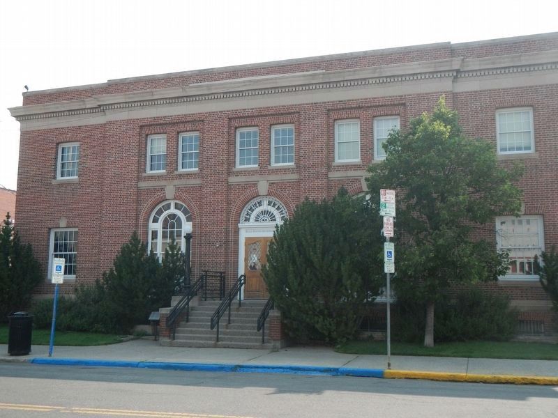
Near East Main Street near North Rouse Avenue, on the right when traveling west.
Chartered in 1866, Gallatin Masonic Lodge No. 6 built this brick corner block in 1883 for an estimated $20,000, then a princely sum. The grandest of several buildings erected during the early 1880s following the arrival of the railroad, this Masonic . . . — — Map (db m192021) HM
On South Willson Avenue near West College Street, on the left when traveling north.
Bozeman real estate and insurance broker Edward M. Gardner and city treasurer George Willson commissioned this extended family home in 1907. George was married to Edward’s stepdaughter Florence and the two families—including five Willson boys—shared . . . — — Map (db m192238) HM
On West Main Street near South 3rd Avenue, on the left when traveling west.
Before the 1880s, Catholic missionary priests visited Bozeman about four times a year, holding Mass in private homes and rented halls. The community built its first Catholic church for the Holy Rosary Parish in 1885 at present day Seventh Street and . . . — — Map (db m192025) HM
On West Main Street at North Willson Avenue, on the right when traveling east on West Main Street.
Recognizing the need for a luxury hotel, Bozeman businessmen joined together in a collaboration that spanned nearly a century. Culminating in the opening of the Hotel Baxter on March 2, 1929, the effort involved several generations of dedicated . . . — — Map (db m192024) HM
On East Olive Street at Lindley Place, on the left when traveling west on East Olive Street.
This diminutive neighborly district of thirty-four rather modest, early homes was surveyed and platted as Lindley and Guy’s Addition in anticipation of the arrival of the Northern Pacific Railroad. A lumber planing operation occupied the northwest . . . — — Map (db m192152) HM
On Front Street at Plum Avenue, on the left when traveling north on Front Street.
A Northern Pacific spur line ran in front of this warehouse, originally railroad owned and built in the 1880s for the cold storage of produce. The brick walls are four layers thick with a central air space to maximize insulation; a chute conveyed . . . — — Map (db m192448) HM
On Jackson Creek Road near Bridger Vista Drive, on the left when traveling north.
Built in 1905, Malmborg School is one of the most architecturally interesting one-room schoolhouses in Gallatin County. The one-story octagonal school originally sported an open front porch with wooden Doric columns resting on high plinths. An open . . . — — Map (db m191973) HM
On South Willson Avenue at West Dickerson Street, on the left when traveling north on South Willson Avenue.
The design for this two-and-one-half-story home came from architect D. S. Hopkins, of Grand Rapids, Michigan, who published numerous “pattern books” of architectural plans. The Queen Anne style defines the residence, which features an asymmetrical . . . — — Map (db m192373) HM
On North Wallace Avenue near East Cottonwood Street, on the right when traveling north.
Gallatin County boasted twenty-seven grain elevators in 1915, a testament to farming’s important economic role. Despite drought and low commodity prices, Montana Mercantile added this towering elevator to the Bozeman skyline in 1933. It added the . . . — — Map (db m192445) HM
On North Tracy Avenue at East Villard Street, on the right when traveling north on North Tracy Avenue.
The twenty-eight homes along this stretch of North Tracy Avenue illustrate the extensive residential development that occurred north of Main Street. Impressive homes at 322 and 316 North Tracy, built in 1890 and 1900, and two bungalows at 519 and . . . — — Map (db m192451) HM
On North Wallace Avenue near East Davis Street when traveling north.
As Bozeman made its bid for state capital, the construction of fashionable homes and buildings contributed to the town’s promotional efforts. Economic depression in 1893 and designation of Helena as state capital in 1894 tempered the boomtown . . . — — Map (db m192376) HM
On South Willson Avenue near West College Street, on the right when traveling north.
A full-length front porch welcomed visitors to the clapboard home constructed on this lot in 1904. Robert and Edith Cooley purchased the residence from Golden Rule bookkeeper R. A. Black the following year. The couple had moved to Bozeman in 1899 . . . — — Map (db m192235) HM
On West Olive Street at South Tracy Avenue, on the right when traveling west on West Olive Street.
The first services were held in this lovely Gothic style Episcopal church in October 1890. Built at a time when Bozeman hoped to become the capital of Montana, the church reflects the optimism and prosperity that came on the heels of the gold rush . . . — — Map (db m192067) HM
On South 3rd Avenue near West Story Street, on the left when traveling north.
Optimistic Bozeman entrepreneurs John Dickerson, Walter Cooper, and Nelson Story (of cattle drive fame) platted the Park Addition in 1883. Despite the arrival of the Northern Pacific that year, the addition remained undeveloped until the late 1890s, . . . — — Map (db m192180) HM
Near West Kagy Avenue at South 3rd Avenue, on the left when traveling west.
The Museum of the Rockies acquired the Tinsley house in 1986, which helped complete the plans for a working Living History Farm exhibit. The house was moved from Willow Creek, MT in one piece and restored to its original 1890s condition. After . . . — — Map (db m205926) HM
On South 3rd Avenue near West Curtiss Street, on the left when traveling north.
Thomas and Anna Noble came to Bozeman in 1890 from Salesville. Thomas, an experienced logger, secured employment with the Prey Lumber Company. After S. C. Kenyon purchased the firm, Kenyon and Noble became partners in the business, furnishing early . . . — — Map (db m192177) HM
On East Main Street near North Taylor Avenue, on the right when traveling west.
Railroad anticipation sparked a frenzied building boom prompting a shortage of brick that postponed completion of this popular watering hole for nearly two years. Begun in 1880, Phil Skeehan’s Tivoli Beer Hall finally opened in 1882. William Beall . . . — — Map (db m192023) HM
On South Main Street at East Cedar Street, on the right when traveling west on South Main Street.
John Quincy Adams of the Milwaukee Land Company, a subsidiary of the Chicago, Milwaukee and St. Paul Railway, platted the present town of Three Forks in 1908. Unlike most railroad officials, Adams and his son, B. S. Adams, took an unusual personal . . . — — Map (db m192664) HM
Near Three Forks Airport Road near Frontage Road (State Highway 2), on the left when traveling west.
Aviation captivated America during the 1920s, particularly when Charles Lindbergh flew solo across the Atlantic in 1927. The United States made rapid strides and airfields opened all over the country. The town of Belgrade constructed Gallatin . . . — — Map (db m206125) HM
On East Cedar Street near 2nd Avenue East, on the right when traveling west.
The Milwaukee Land Company, a subsidiary of the Milwaukee Road, established the town of Three Forks in 1908. Company land agent John Q. Adams chose this townsite and held a lot sale in 1908. Buyers came by the trainload, purchasing 250 lots. . . . — — Map (db m192666) HM
On South Main Street near West Cedar Street, on the left when traveling north.
The town of Three Forks, born to serve as a division point for the Chicago, St. Paul, and Milwaukee Railway, took root in 1908. As the town grew to a sizable settlement of 2,300, the Empire Theatre opened to serve local audiences. Manager David R. . . . — — Map (db m192662) HM
On South Main Street at West Cedar Street, on the left when traveling north on South Main Street.
Solid bank buildings were designed to assure customers that their money was safe from both theft and bank failure—a tenuous premise in the days before Federal Deposit Insurance. Here Romanesque arches, rusticated sandstone, thick masonry walls, and . . . — — Map (db m192663) HM
On Main Street at 3rd Street, on the left when traveling north on Main Street.
Pioneering Southern Methodist minister Learner Blackman Stateler preached his first sermon in Willow Creek on Christmas Day 1864, in a cabin built by a local farmer. Like many of the area’s early residents, Stateler was a Southern sympathizer from . . . — — Map (db m193003) HM
On Main Street at First Avenue West, on the left when traveling north on Main Street.
The arrival of the Milwaukee Railroad in 1908 established Lavina as an important regional center. D. W. Slayton’s Mercantile and L. C. Lehfeldt’s Adams Hotel were the cornerstone businesses of the bustling community. Slayton and Lehfeldt, along with . . . — — Map (db m188967) HM
On Main Street near First Avenue West, on the left when traveling north.
T. C. Power’s stage line established a stop in 1883 where the town of Lavina was born. In 1907, the Milwaukee Road came through attracting new businesses, among them the Slayton Mercantile Co., established in 1908 by Daniel Webster Slayton. A . . . — — Map (db m188968) HM
On Main Street at Railway Avenue West, on the left when traveling north on Main Street.
Rancher Ludwig C. Lehfeldt sold 33,000 acres of ranch land to the Milwaukee Road in 1907 prompting the relocation of the Lavina townsite. Realizing the need for a hotel, Lehfeldt hired architects Link and Haire—who drew the plans for the 1910 . . . — — Map (db m188964) HM
On West Kearney Street at North Sansome Street, on the right when traveling west on West Kearney Street.
Before his death in 1896, pioneering Jewish businessman William Weinstein owned many lots, including this one, in Philipsburg. By 1902, his daughter Alice Weinstein Hannah owned the property and the one-story wooden dwelling that stood on the site, . . . — — Map (db m205462) HM
On East Broadway Street near South Sansome Street, on the left when traveling west.
In the 1880s and 1890s, masonry structures gradually replaced the frame buildings left from Philipsburg’s mining camp days. Doe and Hoyer constructed this commercial brick building in 1887. Modini’s Grand Hotel and Restaurant was located in the west . . . — — Map (db m205451) HM
On West Kearney Street near California Street, on the left when traveling east.
Reverend Milton Cook organized Philipsburg’s first Presbyterian congregation in 1877 and Reverend George Edwards came from Missoula to preach once a month. But it was not until 1891 that Reverend Samuel Wishard established a permanent Presbyterian . . . — — Map (db m205541) HM
On East Granite Street at North Sansome Street, on the right when traveling west on East Granite Street.
During the 1880s masonry structures began to replace wood-framed buildings from the mining camp days to form the present town. George H. Harn, who at that time ran one of two local brickyards, probably built this fine residence with his own bricks. . . . — — Map (db m205544) HM
On Franklin Street near West Granite Street, on the left when traveling east.
A beautifully embellished pedimented gable and open porch with spindled balustrade, turned columns, and decorative details highlight this splendid two-and-one-half-story Queen Anne style residence of salmon-colored brick. Mary Schuh, a longtime . . . — — Map (db m205543) HM
On East Kearney Street at North Sansome Street, on the right when traveling west on East Kearney Street.
In January 1889, St. Andrew’s Episcopal Church opened its doors to hold one of the first services in a church in Philipsburg. Placed within the cornerstone the previous year were a Bible, some coins, names of donors, and a copy of the Philipsburg . . . — — Map (db m205457) HM
On West Kearney Street at North Sansome Street, on the right when traveling west on West Kearney Street.
The cornerstone for St. Paul’s Methodist Episcopal Church was laid in 1887. Dedicated September 15, 1890, this modest but rather sophisticated structure was one of Philipsburg’s early churches. Choice of brick and prolonged construction reveal the . . . — — Map (db m205459) HM
On Hot Springs Road near State Highway 69, on the left when traveling west.
For centuries Native Americans have been coming to these pure, flowing hot water springs for rest and healing. Legend tells that they called this area Peace Valley. They agreed to lay down their weapons when they sojourned here, believing that the . . . — — Map (db m186201) HM
On West Centennial Avenue near North Washington Street, on the left when traveling west.
In 1888, Jefferson County voters passed a $40,000 bond issue to build a permanent courthouse. Flourishing gold and silver mines and the advent of the railroad meant the county would see its population quadruple between 1870 and 1890, and there . . . — — Map (db m186193) HM
On Grizzly Drive near Main Street, on the left when traveling south.
Montana pledged its commitment to children with disabilities in 1887 when Territorial Governor Preston Leslie requested funds for a Montana Deaf and Dumb Asylum. Its title, although shocking by today’s standards, reflects accepted nineteenth-century . . . — — Map (db m186195) HM
On West Legion Avenue at North Main Street, on the right when traveling east on West Legion Avenue.
Newlyweds Lot and Hilda Borden arrived in Whitehall early in 1900, and for the next seventy years, their business contributed to the local economy. At first, Lot ran a saloon and Hilda a cafe. The Bordens built the east portion of the present . . . — — Map (db m193009) HM
On Dublin Gulch Road near Biggerstaff Lane, on the right when traveling west.
Congress opened the Flathead Reservation for homesteading in 1910, setting aside several tracts of land for townsite purposes. The town of D’Aste was platted soon after. Thomas P. Quinn operated a store and post office at D’Aste, serving fifty-three . . . — — Map (db m219139) HM
On 4th Avenue Southwest near Eisenhower Street Southwest, on the left when traveling north.
Homebuilding across the country stopped completely during World War II as materials were diverted to the war effort. When residential construction resumed after the war, architects broke with past traditions and embraced modernism. One-story ranch . . . — — Map (db m219135) HM
On Adams Street Southwest at 4th Avenue Southwest, on the right when traveling east on Adams Street Southwest.
The first circuit-riding Methodist ministers, “the Lord’s Horsemen,” arrived in Montana in the 1870s to establish congregations among the territory’s early population. Settlers came to the Flathead when reservation lands opened to homesteading in . . . — — Map (db m219136) HM
On South Rodney Street near East Broadway Street when traveling north.
In September 1887, the Helena Weekly Herald noted “nine first-class brick residences” under construction on South Rodney Street. Among them were three nearly identical duplexes, called Galen Estates after one of the development’s principal . . . — — Map (db m188209) HM
On North Rodney Street at 5th Avenue, on the right when traveling north on North Rodney Street.
An early one-story wooden dwelling stood here by 1884, replaced by 1888 with a two-story brick residence, set slightly back from the street. The home soon found itself ensconced in a busy commercial district. Neighbors included saloons, grocery . . . — — Map (db m188329) HM
On Spencer Street near Pine Street, on the right when traveling north.
Jacob T. Gove, a miner and assayer, developed the Bonanza Chief gold mine near Montana City in 1883, netting over $9,000 from three carloads of ore. With his small fortune, he opened an assay office, built the house next door at 229 for his family, . . . — — Map (db m188180) HM
On Spencer Street near Pine Street, on the right when traveling north.
Mining required back breaking labor and, after the easy pickings were gone, substantial capital. How did prospectors decide whether to continue working particular veins? They brought ore samples from their claims to an assay office, where they were . . . — — Map (db m188179) HM
On West Main Street near Carriage Lane, on the left when traveling west.
Two distinct front porches attest to the separate histories of these two nineteenth-century homes, combined into one in the late twentieth century. The older of the two at 490 West Main was built between 1865 and 1875. Segmentally arched windows and . . . — — Map (db m187480) HM
On Harrison Avenue at Stuart Street, on the left when traveling north on Harrison Avenue.
Senator T. C. Power met A. C. Johnson in Chicago and, taking a liking to the young man, offered him a job out west. The nineteen-year-old came to work as chief clerk at Power’s Fort Benton Mercantile in 1879. Power and Johnson became friends and . . . — — Map (db m187736) HM
On 5th Avenue at North Davis Street, on the left when traveling west on 5th Avenue.
George and Anna Pascoe, both natives of England, moved to Helena from Butte in 1908. George died soon after the couple purchased this home in 1911. Although he was not long a resident of Helena, George, “with a cheery smile and a good word for . . . — — Map (db m187740) HM
On North Last Chance Gulch near East Broadway Street, on the right when traveling north.
The fanciful façade of this nineteenth-century showcase was intended to convey a powerful message. Completed in 1889 for the insurance company of Samuel J. Jones at a cost of $40,000, the vivid imagery is an advertisement, showing how insurance . . . — — Map (db m186556) HM
On South Park Avenue near South Cruse Stree, on the left when traveling north.
Charles Hendrie opened Helena’s first iron foundry on this site before 1868. The property’s third owner, Benjamen K. Tatem, built this two-story residence circa 1875. Wide eaves, low hipped roof, and tall arched windows proclaim Italianate . . . — — Map (db m187475) HM
On 5th Avenue near North Davis Street, on the left when traveling west.
An octagonal tower, decorative brickwork, one-story open porch, and hipped roof identify this appealing Queen Anne style residence built circa 1883. That year launched a period of neighborhood expansion and prosperity, kindled when the tracks of the . . . — — Map (db m188086) HM
Near South Warren Street near Miller Street, on the left when traveling north.
Legend has it that architect James F. Stranahan built this striking residence of locally quarried blue granite for his bride, Leona, in 1889. Stranahan died, however, leaving the home unfinished. Records do show that Leona briefly owned the . . . — — Map (db m188520) HM
On East Lockey Avenue near Roberts Street, on the left when traveling west.
Established by the state legislature in 1901, Montana’s Board of Health was originally housed in two small offices in the capitol building. As the state devoted more attention to public health during the Progressive Era, the Board’s responsibilities . . . — — Map (db m186778) HM
On South Last Chance Gulch near East Broadway Street when traveling north.
Historic maps and early directories reveal that this splendid business block was constructed circa 1890. Morris Auerbach, in business with Israel L. Israel and Adolph Marks during the 1890s, was the original occupant. Their Boston Clothing Company . . . — — Map (db m186610) HM
On Dearborn Avenue near Power Street, on the left when traveling north.
Newlyweds Isaac Boyer and Carrie Feldberg Boyer moved to their new home within a year of their 1907 marriage. The refined, hipped-roof residence may well have been built to order. The two-story house features popular Colonial Revival style details, . . . — — Map (db m187660) HM
On North Ewing Street, at East 7th Avenue, on the right when traveling north on North Ewing Street,.
The home of territorial Governor Benjamin Potts sat on this property from the 1870s until this grand residence was built for prominent Helenans Charles B. and Mable Power circa 1907. Power’s father was merchant prince and early U.S. Senator T. C. . . . — — Map (db m188332) HM
On North Last Chance Gulch at East Lawrence Street, on the right when traveling north on North Last Chance Gulch.
Prominent Helena investor and real estate developer Charles W. Cannon commissioned the firm of Wallace and Thornborgh to construct this building for $10,000. Completed in 1890, the building reflects expansion and urbanization in the downtown area . . . — — Map (db m187145) HM
On South Last Chance Gulch near East Broadway Street, on the left when traveling north.
Most of Helena’s earliest commercial buildings fell victim to the fires that plagued the gulch. This simple 1860s commercial building, originally a single story of stone construction, was a notable exception, surviving a disastrous conflagration in . . . — — Map (db m186670) HM
On South Park Avenue at Reeder's Alley on South Park Avenue.
According to reminiscences of the Butts family, builders of the Pioneer Cabin next door, two cabins stood on this lot in 1865. William Davenport likely built one for his family and the William H. Parkinsons occupied the other. Sallie Davenport, . . . — — Map (db m187373) HM
On North Ewing Street near East 6th Avenue, on the left when traveling north.
Helena entrepreneur William Chessman built these exemplary Queen Anne style townhouse apartments in 1891 while in residence across Sixth Avenue at 304 North Ewing. Gables, bays, and a rounded turret handsomely demonstrate the architectural . . . — — Map (db m188458) HM
William C. Child came to Montana from Iowa in 1870 as an agent for the Wells Fargo Express Company. President U. S. Grant soon appointed him territorial land office registrar and Child made a small fortune in mining investments. This two-story barn, . . . — — Map (db m188331) HM
On North Benton Avenue near West Lawrence Street, on the left when traveling east.
John B. Sanford was born on a farm in Maine to Quaker parents. His father, then retired, had been captain of a whaling vessel. Sanford came to Montana in 1864 at the age of 29. On the journey west he formed a partnership with 24-year old Christmas . . . — — Map (db m187589) HM
On East Lockey Avenue near Roberts Street, on the left when traveling west.
Following World War II, Montana’s growing state agencies desperately needed all types of space. Consequently, in 1946 the Montana State Postwar Planning and Construction Commission recommended building a laboratory where all testing for state . . . — — Map (db m186915) HM
On North Last Chance Gulch at East Placer Avenue, on the right when traveling north on North Last Chance Gulch.
The Colorado Building is a rich illustration of Helena’s commercial blossoming during the early twentieth century. The Mountain States Telephone and Telegraph Company built the structure in 1922, thereby completing this block in the town’s more . . . — — Map (db m187243) HM
On South Last Chance Gulch near East Broadway Street, on the left when traveling north.
Reputedly the first two-story building on Main Street and one of Helena’s few remaining structures dating to the 1860s, this stone building originally housed offices and furnished lodgings. Miner and prominent merchant E. M. Dunphy purchased the . . . — — Map (db m186607) HM
On Harrison Avenue at Floweree Street, on the left when traveling north on Harrison Avenue.
Locally quarried blue-gray granite complements the shingled upper stories in this commanding nineteenth-century home. Both this residence and the one next door are stellar examples of the eclectic Shingle style. The wide porch and asymmetry are . . . — — Map (db m187674) HM
On West Main Street near Carriage Lane, on the left when traveling north.
Elisha Poad arrived in Helena in 1867 by way of mining camps in California and Nevada. Poad was a native of Cornwall, England, an area with over two thousand years of mining history. Attracted to Helena’s placer mines, he was later associated with . . . — — Map (db m187478) HM
On Spencer Street near State Street, on the right when traveling north.
Lydia Jane English was recently widowed when she and her family moved into this substantial Italianate style residence, built in 1888. Her husband, miner Harvey W. English, was a prominent Helena pioneer who served in the territorial legislature, as . . . — — Map (db m188181) HM
On North Last Chance Gulch near East Lawrence Avenue, on the right when traveling north.
Montana’s leading architectural firm of Link and Haire designed this attractive building for Charles George Eybel in 1922. Stuccoed walls and a raftered cornice along the roofline, reminiscent of the Spanish Colonial Style, combine with a smooth . . . — — Map (db m187136) HM
On East Lawrence Street near Fuller Avenue, on the right when traveling west.
A probate judge deeded brothers Anton and Martin Holter this property in 1872. The prominent and wealthy Holters operated milling, hardware, real estate, and construction companies. The Holters set up a lumber yard here, which they operated until . . . — — Map (db m187142) HM
On North Park Avenue near West 6th Avenue, on the left when traveling north.
Emphasizing balance, symmetry, and restraint, the Renaissance Revival style organizes large buildings into horizontal layers, with each floor becoming increasingly more refined. Designed by James Knox Taylor, the Federal Building achieves this . . . — — Map (db m187314) HM
On North Park Avenue near West Lawrence Street, on the left when traveling north.
The Helena branch of the Federal Reserve Bank opened in 1921, the result of lobbying by Norman B. Holter and other farsighted local businessmen. It distinguished Helena as the smallest town in the country to host such a bank. When the 1935 . . . — — Map (db m187311) HM
Entrepreneur T. H. Kleinschmidt was the original owner of this early Italianate style dwelling, built as investment property circa 1884. Kleinschmidt, three times elected mayor of Helena, had diverse local business interests including utilities, . . . — — Map (db m188237) HM
The welfare of the community depended upon this prominent landmark, strategically placed atop the town’s most prominent hill. Fire was the grim reaper that stalked all western mining camps, and Last Chance Gulch was no exception. Hastily built log . . . — — Map (db m188517) HM
On North Last Chance Gulch near East 6th Avenue, on the right when traveling north.
This magnificent structure was the second home of Montana Territory’s first bank, chartered in 1866. Combining Romanesque, French Second Empire, and popular Victorian-period stylistic elements, the talented St. Paul firm of Hodgson, Wallingford and . . . — — Map (db m186486) HM
On North Park Avenue at West Lawrence Street, on the right when traveling north on North Park Avenue.
Outstanding architecture and a long history of community service make this stunning landmark much beloved. It is the only known example of prominent architect C. S. Haire’s work in the Richardsonian Romanesque style. Magnificent round arches, a . . . — — Map (db m187312) HM
On North Rodney Street at East 7th Avenue, on the right when traveling north on North Rodney Street.
Rodney Street was prime residential real estate when developer Richard Lockey sold this lot to Francis Pope in 1872. Pope, one of Helena’s first druggists, built a modest home on the property. He and his wife Hannah were prominent in the community . . . — — Map (db m188376) HM
On Madison Avenue near Stuart Street, on the left when traveling north.
George and Esther Grossberg built this Craftsman style bungalow in the early 1920s. The mix of multi-colored brick and stucco blends beautifully into the surrounding landscape. Tucked between two Victorian-era homes, this charming 1920s residence . . . — — Map (db m187738) HM
On Dearborn Avenue near Power Street when traveling north.
The steamboat Alone brought Stephen Gilpatrick to Montana on the cusp of the 1863 gold rush to Alder Gulch. When mining proved a disappointment, Gilpatrick moved on to Last Chance where he and a partner established the camp’s first stationery store. . . . — — Map (db m187662) HM
On North Last Chance Gulch near East 6th Avenue, on the left when traveling north.
On July 16, 1928, a devastating fire swept between the Granite and Gold Blocks (note inscription, second story center). The structure was rebuilt by then-owner Charles Benton Power and was the last major downtown commercial building constructed by . . . — — Map (db m186483) HM
This building is an excellent example of transitional Western Commercial architecture before the advent of more ornate styles. The simple, narrow plan enhanced by decorative windows is typical of the 1870s and early 1880s. A pressed metal cornice . . . — — Map (db m186482) HM
On North Rodney Street at East 6th Avenue on North Rodney Street.
Territorial Governor Preston Leslie was a resident of this early Helena home, constructed in the late 1870s. Originally built in the Gothic Revival style popular during Helena’s townsite period, later remodeling added classical details. The two . . . — — Map (db m188330) HM
On North Park Avenue near West Lawrence Street, on the right when traveling north.
Meriwether Lewis’s Masonic apron and an O. C. Seltzer mural depicting the first Masonic meeting in Montana are among the treasures displayed in “the home of Montana Masonry.” A dynamic political and social force since early territorial days, the . . . — — Map (db m187310) HM
On Grizzly Gulch Drive near Oro Fino Gulch Drive, on the right.
Lime manufacture was an essential industry for building in brick and stone in the nineteenth century. The Grizzly Gulch outcrops and the kilns below them supplied the entire region with lime of the highest quality. Joseph O’Neill built the first of . . . — — Map (db m187580) HM
On Rodney Street at State Street when traveling north on Rodney Street.
This first permanent settlement of the gold camp at Last Chance Gulch offers a glimpse of early Helena from the late 1860s to the 1890s. By the 1870s, a Catholic cathedral, St. John’s Hospital, two schools, and dormitories presided over the district . . . — — Map (db m188182) HM
This first permanent settlement of the gold camp at Last Chance Gulch offers a glimpse of early Helena from the late 1860s to the 1890s. By the 1870s, a Catholic cathedral, St. John’s Hospital, two schools, and dormitories presided over the district . . . — — Map (db m188519) HM
On South Davis Street near North Hillsdale Street when traveling north.
Danish immigrants Henry and Matilda Blase settled on this property in the 1880s. Like other working-class Europeans who lived in the neighborhood, Blase was a man of many occupations: bartender, saloon keeper, jailer, miner, and landscape gardener. . . . — — Map (db m188113) HM
On West Main Street near Grizzly Gulch Drive, on the right when traveling west.
English immigrants Frances and Henry Hay came to Helena in the mid-1860s and were among the first to settle on West Main where Hay mined a claim. Their log cabin became the center of the present residence, built circa 1870. A switchback path leads . . . — — Map (db m187578) HM
On East Broadway Street near Rodney Street, on the left when traveling west.
Professor T. F. Campbell built a log cabin on this corner where he opened Helena’s first public school in 1865. Druggist Henry M. Parchen founded his long-time Helena apothecary that same year. Parchen acquired this property circa 1872 and . . . — — Map (db m188231) HM
On East Broadway Street near Spencer Street, on the left when traveling west.
Pioneer businessmen Anton and Martin Holter made fortunes in hardware, construction, mining investments, and real estate development. The brothers owned a number of lots in south central Helena, including three adjoining lots here on Broadway. The . . . — — Map (db m188111) HM
On Spencer Street near Pine Street, on the right when traveling north.
Contractors Anton and Martin Holter, who operated Helena’s first sawmill, built this frame residence as a rental investment in 1888. Developers like the wealthy Holter brothers built a number of south-central residences during the prosperous 1880s, . . . — — Map (db m188178) HM
Near North Last Chance Gulch near East Lawrence Street, on the right when traveling north.
Helena architects Heinlein and Matthias designed this elegant European-style hotel, formerly the Windsor House. Built in 1888, it is Montana’s only known example of a prefabricated iron façade. The locally pre-cast façade represents a building trend . . . — — Map (db m187148) HM
On North Ewing Street at East 5th Avenue, on the right when traveling north on North Ewing Street.
During his second term of office in 1903, Montana’s first governor J. K. Toole commissioned Eugene Fisk to build this magnificent home of locally quarried red porphyry and brick. Fisk, who also designed the 1880s Unitarian Church (now Grandstreet . . . — — Map (db m188461) HM
On Breckenridge Street near North Rodney Street, on the right when traveling west.
Livery stables rented and boarded horses, providing a critical service in the nineteenth century when transportation depended upon reliable mounts. Allen Livery is Helena’s best preserved reminder of this vital business and also recalls the . . . — — Map (db m188232) HM
On South Rodney Street at Miller Street, on the left when traveling north on South Rodney Street.
n May of 1890, Montana’s first governor, Helena trial lawyer and territorial statesman Joseph Kemp Toole, brought his bride, Lilly, to live in the family home on Rodney Street. The territorial brick residence had been constructed before 1880 for . . . — — Map (db m188204) HM
The 1982 Justice Building and Montana State Library, designed by Page-Werner and Partners of Great Falls, was the last building constructed under the ambitious 1972 Capitol Campus Master Plan. Designed to house the Supreme Court, Attorney General’s . . . — — Map (db m187069) HM
On North Warren Street at East 6th Avenue, on the right when traveling north on North Warren Street.
Entrepreneur Reinhold H. Kleinschmidt built this block with five storefronts and upstairs lodging rooms circa 1892. Among his first commercial tenants was Charles Grossman, a wallpaper hanger and painter, whose business was in the corner storefront. . . . — — Map (db m188460) HM
On West Main Street near Carriage Lane, on the left when traveling north.
This rare example of European half-timber construction in the midst of a Montana mining camp beautifully illustrates how pioneer buildings often reflected the cultural traditions of their builders. After distinguished service as an infantryman in . . . — — Map (db m187484) HM
636 entries matched your criteria. Entries 101 through 200 are listed above. ⊲ Previous 100 — Next 100 ⊳