On Main Street at North Wall Street, on the right when traveling north on Main Street.
(side 1)
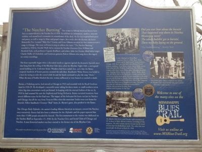
One of the deadliest fires in American history took the lives of over 200 people, including bandleader Walter Barnes and nine members of his dance orchestra at the Rhythm Club (less than a mile southeast of this site) on April 23, . . . — — Map (db m70811) HM
On St. Catherine Street, 0.1 miles west of Orange Street, on the right when traveling west.
. Eliza Smith, an antebellum "free woman of color," purchased property on St. Catherine Street in the 1850s. Her daughters and their families built new houses on the property in the 1880s.28 St. Catherine Street (above) was the ca. 1885 home of . . . — — Map (db m108276) HM
On Martin Luther King Street at St. Catherine Street & Jefferson Street, on the left when traveling north on Martin Luther King Street.
300 North Martin Luther King Street (above) is home to the city's oldest funeral business.Robert D. Mackel (below) opened Bluff City Undertaking in 1898 at the corner of Jefferson and North Rankin Streets. About 1911 he relocated the business to . . . — — Map (db m108600) HM
On St. Catherine Street west of Sixth Street, on the left when traveling west.
The Union School (above) was the first public school built by the City of Natchez for African American students. Built in 1871 by contractor P. E. Willman, the Union School was a grand brick edifice which stood at the southeast corner of North . . . — — Map (db m115615) HM
On St. Catherine Street east of Junkin Street, on the right when traveling west.
Professional dealers, traffickers and speculators, by purchase, by hook, crook and sometimes outright kidnapping, tore apart mothers, fathers, daughters, sons, brothers, sisters, uncles, aunts, cousins, babies, young children, relations and friends . . . — — Map (db m114508) HM
On Cemetery Road, 0.2 miles north of Maple Street, on the right when traveling north.
Jackson State University was founded here in 1877 in the former U.S. Marine Hospital. Known as the Natchez Seminary, the school was founded by the American Baptist Home Mission Society and the Mississippi Baptist Convention Association led by H.P. . . . — — Map (db m143710) HM
Near N. Broadway Street north of Main Street, on the right when traveling south.
Bontura, built in 1851, was the home of Robert Smith, a free African American who ran the city’s most successful carriage business in the 1850s. The house stands at the head of Silver Street, which leads to Natchez Under-the-Hill. Smith . . . — — Map (db m87179) HM
On Main Street east of North Pearl Street, on the right when traveling west.
(side 1)
Clarence “Bud” Scott, Sr., led one of the most popular dance bands in the Mississippi-Louisiana region for several decades beginning around 1900. Scott (1876-1938), a lifelong Natchez resident, was renowned among both . . . — — Map (db m70852) HM
On St. Catherine Street near 6th Street, on the left when traveling west.
Henry Dumas poses on the front steps of 69 St. Catherine Street. Henry managed the Dumas Pharmacy at 707-09 Franklin Street, a building that also housed the medical practice and sanitarium of his brother Dr. Albert W. Dumas, Sr. In 1940 Dr. Dumas . . . — — Map (db m115637) HM
On Saint Catherine Street east of Abbott Street, on the right when traveling west.
Home of the first African American Physician in the Natchez area, Built in the 1880's Has been placed on the National Register of Historic Places by the United States Department of Interior. — — Map (db m226651) HM
On St. Catherine Street west of Orange Street, on the right when traveling west.
The Dr. John Banks House was built in the Queen Anne style about 1890 and was slightly remodeled in the Colonial Style after about 1905. Frank Robinson, grandson of Dr. John Banks, retired part time to Natchez and restored the house in the . . . — — Map (db m106297) HM
Near N. Broadway Street north of Main Street, on the right when traveling south.
(Front Side)
The Ealey family of Sibley has produced some of the most talented musicians to emerge from the Natchez area. Brothers Theodis, YZ, and Melwyn Ealey performed together locally in the band YZ Ealey and the Merry Makers in the . . . — — Map (db m87181) HM
On Liberty Road at St Catherine Street and Devereaux Drive (Business U.S. 61), on the left when traveling north on Liberty Road.
Site of the South's second largest slave market in the 19th century. Enslaved people were also once sold on city streets and at the landing at Natchez Under the Hill. Natchez slaves were freed in July, 1863, when Union troops occupied the city. The . . . — — Map (db m37433) HM
On Liberty Road south of St. Catherine St. (U.S. 61), on the right when traveling north.
[Panel 1:]
Natchez in the Center of Slavery
Slavery is central to American history. The labor of enslaved African Americans built much of the nation’s wealth and enabled it to gain its economic independence. The enslavement of people . . . — — Map (db m41533) HM
On Saint Catherine Street west of Orange Avenue, on the left when traveling west.
First Catholic church in the Mississippi valley with entire congregation of Afro-American descent. Its school has been continually educating youth since 1890. — — Map (db m103798) HM
On St. Catherine Street at Orange Avenue, on the right when traveling west on St. Catherine Street.
In 1889 Bishop Thomas Heslin started the first parish for Roman Catholic African Americans in Mississippi. He first oversaw construction of a small frame church (above left) on Beaumont Street and brought Father A.N.J. Peters to Natchez to become . . . — — Map (db m104502) HM
On St. Catherine Street near Abbott Street, on the right when traveling west.
The portion of St. Catherine Street that extends from the site of the Rhythm Night Club to D'Evereux Street was originally part of the property of the city's first public hospital (above).The hospital fronted St. Catherine and stood on a hill on . . . — — Map (db m108586) HM
On North Wall Street at High Street, on the left when traveling south on North Wall Street.
Joseph Neibert built Choctaw in 1836 as his mansion townhouse. Neibert was a cotton planter. In the 1830s he and his partner Peter Gemmel, operated the city's most successful building firm, which employed both white and enslaved . . . — — Map (db m104476) HM
On North Rankin Street at Jefferson Street, on the right when traveling south on North Rankin Street.
Zion Chapel African Methodist Episcopal (A.M.E.) Church was built in 1858 as the Second Presbyterian Church, a mission of First Presbyterian Church. Zion Chapel acquired the building in 1866, when Hiram R. Revels served as pastor. The . . . — — Map (db m127093) HM
On Main Street at South Wall Street, on the left when traveling west on Main Street.
The Old Natchez Post Office was built in 1904 on the site of William Johnson's Main Street barbershop. Before his 1851 death, Johnson also owned two other barbershops in town. He used both freed and enslaved black workers who served only . . . — — Map (db m127074) HM
On Franklin Street at North Pearl Street, on the left when traveling east on Franklin Street.
The dramatic looking Natchez Hotel (no longer standing) was built in 1891. Within a few years, parts of the building began to disappear in stages. The tent-like dome went first in a storm, and a 1926 fire destroyed most of the structure. . . . — — Map (db m127090) HM
On St. Catherine Street at 6th Street, on the left when traveling west on St. Catherine Street.
John R. Lynch turned to writing in his later years and wrote the Facts of Reconstruction in 1913. He completed his autobiography Reminiscences of an Active Life when he was 90, two years before his death in 1939.Lynch invested . . . — — Map (db m115927) HM
On St. Catherine Street at 6th Street, on the left when traveling west on St. Catherine Street.
The photograph of the 1946 Brumfield High School Choral. Club, taken in the front yard of Brumfield, provides the best image of the Louis Winston House on the left. The house unfortunately burned in the 1990s. The house on the right, which still . . . — — Map (db m114661) HM
Near John A Quitman Boulevard west of Melrose Avenue, on the left when traveling west.
Natchez postmaster John Hankinson built Monmouth on two adjacent, 15-acre tracts, in 1818. He named his estate after his place of origin in Monmouth County, New Jersey. Monmouth was sold in 1826, to John A. Quitman. Quitman, born in New York, lived . . . — — Map (db m243751) HM
On Liberty Road at Stanley Davis Road, on the right when traveling west on Liberty Road.
The original church was located on Montgomery Plantation when it burned down during the civil rights movement of 1963. It was rebuilt at this site in 1964. — — Map (db m136946) HM
On St. Catherine Street east of McCabe Street, on the left when traveling west.
Alexander Lightfoot "Papa George" Papa George Lightfoot [1924-1971], he lived down the street from the alley I came up in, down on St. Catherine Street....He was a hustler, he had a snowball wagon, he sold peanuts. He would blow his harp . . . — — Map (db m108160) HM
On St. Catherine Street near Old D'Evereux Street, on the left when traveling west.
The Deacons for Defense and Justice armed themselves in self-defense as a response to the attempted murder of local NAACP president George Metcalfe, whose car was bombed by the Ku Klux Klan in 1965. The first meeting of the Natchez Deacons was . . . — — Map (db m116326) HM
On St. Catherine Street, 0.1 miles west of McCabe Street, on the left when traveling west.
The National Guard patrolled St. Catherine Street on September 3, 1965, not long after the August 27 bombing that nearly killed George Metcalfe, president of the local chapter of the Natchez Association for the Advancement of Colored People . . . — — Map (db m115639) HM
On Saint Catherine Street west of Abbott Street, on the right when traveling west.
On April 23, 1940, 209 African Americans died in a fire at the Rhythm Club, located at this site. An overflow crowd, which included civic and cultural leaders, had come to hear the Walter Barnes Orchestra of Chicago. Considered among America's most . . . — — Map (db m103794) HM
On S. Broadway Street, on the right when traveling south.
Noted African-American author of Native Son and Black Boy was born in 1908 near Natchez, where he spent his early childhood. His lifelong quest for freedom led him to Paris, France, where he died in 1960. — — Map (db m10059) HM
On East Woodlawn Street at Garden Street, on the left when traveling north on East Woodlawn Street.
Childhood home of noted American author Richard Wright, while he lived with grandparents Richard and Margaret Wilson in the Woodlawn neighborhood. Author of "Native Son" and "Black Boy", Wright was born outside Natchez in rural Adams County in 1908. . . . — — Map (db m170486) HM
On Madison Street east of North Union Street, on the left when traveling east.
Rose Hill is the oldest black baptist congregation in the state, with origins dating to 1837. This 1908 building replaces the first wooden church and contains a 1912 Moller pipe organ. Randle Pollard was the first official pastor, serving from . . . — — Map (db m105229) HM
On North Union Street at Grant Street on North Union Street.
In memory of the Afro-American Experience in Natchez
Adams County Mississippi of segregated schools for
black children. Our treatment was second class at best,
but our principals and teachers were first class in their
guidance and values. Full . . . — — Map (db m224619) HM
On St. Catherine Street west of Auburn Street, on the left when traveling west.
John J. Nosser, Mayor of Natchez from 1962 to 1968, was born in Lebanon in 1899 and immigrated to the United States in 1919. Mississippi welcomed a number of Lebanese immigrants who became some of the most successful businessmen in their . . . — — Map (db m114458) HM
On St. Catherine Street west of 6th Street, on the left when traveling west.
The will of William Barland, a wealthy planter and downtown property owner, disclosed an interesting domestic relationship that has long intrigued historians. Proven in 1816, the will legally acknowledged Barland's relationship with "friend and . . . — — Map (db m115928) HM
Near State Street east of South Canal Street, on the right when traveling east.
The house to your left, completed in 1841, was built by William Johnson. Born a slave in 1809 in Natchez and freed in 1820, Johnson learned the profession of barbering from his brother-in-law. At an early age, he owned a barbershop and later . . . — — Map (db m92857) HM
Photographer Earl Norman stood on Jefferson Street and snapped this view of the intersection of St. Catherine, Martin Luther King and Jefferson streets.A single column of the portico of Zion Chapel A.M.E. Church appears on the far right. Holy . . . — — Map (db m108599) HM
On Minor Street south of North Doctor M.L.K. Jr. Street, on the left when traveling south.
Wharlest Jackson was a Natchez Civil Rights activist who lost his struggle for racial equality on February 27, 1967. The explosion of a bomb implanted under his truck took his life. Members of the Ku Klux Klan targeted Jackson, because he was . . . — — Map (db m105223) HM
On Saint Catherine Street near O'Brien Street, on the right when traveling west.
Lettie Stanton, most likely born into slavery and possibly at Brandon Hall, had a stable relationship with cotton planter William Page, who never married anyone else and fathered her two daughters, heirs to the Page estate.Margaret Page, daughter of . . . — — Map (db m114292) HM
On State Street, 0 miles east of So. Canal Street (Business U.S. 61), on the right when traveling west.
William Johnson
1809-1851
was a free African American Businessman and Diarist. His diary, covering the period from 1835-1851 and published in 1951, contains an extensive description of everyday pre-Civil War life; it is a valuable . . . — — Map (db m34877) HM
On Jefferson Street near North Doctor Martin Luther King Jr. Street, on the left when traveling west.
Acquired 1868 by Zion Chapel whose minister Hiram R. Revels became the first black U.S. Senator and first president of Alcorn State University. Originally built in 1858 as the Second Presbyterian Church. — — Map (db m103793) HM
On North Martin Luther King Street at St. Catherine Street, on the right when traveling west on North Martin Luther King Street.
Henry Gurney photographed Zion Chapel A.M.E. Church in 1866, the year the congregation bought the building built in 1858 as the Second Presbyterian Church. Zion Chapel had earlier purchased the Methodist Church that fronted Union Street between . . . — — Map (db m110513) HM
On North Parkway Street, on the right when traveling north.
The Corinth Contraband Camp offered former slaves the first step toward self-sustainability and freedom through profitable farming. These men, women and children grew 300 acres of cotton and 400 acres of vegetables. All of the crops were sold, and . . . — — Map (db m153404) HM
On Polk Street at East Linden Street, on the right when traveling north on Polk Street.
On May 10, 1863, troops of the Corinth garrison stacked their arms and gathered near the Verandah House for a speech by U.S. Army Adjutant General Lorenzo Thomas. At its former location just around the corner, Duncan House would have been an ideal . . . — — Map (db m155259) HM
On North Parkway Street, on the right when traveling north.
(Main Plaque): Here a newly freed people took their unswerving first steps on the long road to full citizenship. (Side Plaque): "This is a great opportunity afforded your race. Will you improve it?" --Lorenzo Thomas, Adjutant General, . . . — — Map (db m182915) HM
On Jackson Street at Childs Street, on the right when traveling north on Jackson Street.
This unusual Civil War photograph captures a news event as it is happening, rather than recording its aftermath. In the middle of the scene is a canvas topped speakers platform from which Union Adjutant General Lorenzo Thomas is speaking to . . . — — Map (db m89030) HM
On Walnut Drive at North Church Streeet, on the left when traveling north on Walnut Drive.
Founded as the Liberty Colored Church in March 1870 after fifteen black members requested letters of dismissal from Liberty Baptist Church to organize their own congregation. Under the leadership of their first pastor, Rev. Fred Stirling, these . . . — — Map (db m92617) HM
On Tipton Street at East South Street, on the right when traveling north on Tipton Street.
Opened in 1925, the Attala County Training
School stood here. The school provided
vocational education for African American
students. Built mainly with local labor
and funds, the school also received
assistance from the Rosenwald Fund. . . . — — Map (db m244504) HM
On Ripley Avenue (Mississippi Route 370) east of South Main Street, on the right when traveling east.
(side 1)
As a producer, studio engineer, trumpeter and bandleader, Willie Mitchell played a central role in the rise of Memphis as a center for soul music. Mitchell, born in Ashland on March 1, 1928, made many recordings under his own name, . . . — — Map (db m171412) HM
On 1st Street at Fava Street, on the right when traveling north on 1st Street.
Highway 61, "the blues highway," is lined with the birthplaces of blues, R&B, and gospel artists all along its route in Mississippi, and even small communities such as Alligator share in this proud musical legacy. Performers born or raised around . . . — — Map (db m154805) HM
On Main Street (State Highway 1) at Preston Street (State Highway 448), on the right when traveling north on Main Street.
Blues saxophonist extraordinaire Eddie Shaw was born on a Stringtown plantation on March 20, 1937. He learned music at school in Greenville and performed in various local bands before moving to Chicago to join the Muddy Waters band. Shaw served as . . . — — Map (db m154795) HM
On Main Street (State Highway 1) at Preston Street (State Highway 448), on the right when traveling north on Main Street.
(Front)
Benoit native Eddie Taylor, an architect of the post-World War II Chicago blues genre, was renowned for his work both as a bandleader and accompanist. He was best known for shaping the distinctive sound of Jimmy Reed, a childhood . . . — — Map (db m154785) HM
On South Chrisman Avenue at Ruby Street, on the right when traveling south on South Chrisman Avenue.
Returning home from WWII, Cleveland businessman Amzie Moore (1911-1982) became a principal architect of early civil rights activism as a founding member of the Mississippi NAACP and the Regional Council of Negro Leadership. Convinced that . . . — — Map (db m90128) HM
On South Chrisman Avenue at Ruby Street, on the right when traveling south on South Chrisman Avenue.
Amzie Moore (1911-1982), a local Civil Rights leader, built this house
in 1941. An army veteran, Moore also worked for the U.S. Postal
Service. After returning from WWII, Moore dedicated himself to the
civil rights movement, co-founding the . . . — — Map (db m90074) HM
On South Chrisman Avenue near Collins Street, on the left when traveling north.
Side 1
During the segregation era many towns in Mississippi had a particular street that served as the center of African American business and social life, catering not only to townsfolk but to farm hands and sharecroppers from the countryside . . . — — Map (db m170498) HM
On Ruby Street near Aloe Avenue, on the right when traveling east.
Side 1
Despite their conceptual differences, gospel, the Sunday morning music of the church, and blues, the Saturday night music of the juke joint, share some of the same roots, influences and musical traits. Many African African singers have . . . — — Map (db m170501) HM
On West Sunflower Road (State Highway 8) at North 2nd Avenue, on the right when traveling west on West Sunflower Road.
Side 1
The Los Angeles-based GRAMMY Museum’s decision to open a sister museum here in Cleveland in 2016 was a testament to Mississippi's rich musical heritage in blues, country, gospel, rock and other genres. Among Mississippi’s many GRAMMY . . . — — Map (db m170502) HM
On South Court Street at North Pearman Avenue, on the right when traveling west on South Court Street.
Front
In W.C. Handy's famous account of his "enlightenment" in Cleveland, a ragged local trio was showered with coins after Handy's orchestra of trained musicians had been unable to similarly excite the crowd. In early manuscripts of . . . — — Map (db m90071) HM
On East Main Street (State Highway 444) at East Park South (Old State Route 61), on the left when traveling west on East Main Street.
(front)
Duncan has earned its place in blues history as the birthplace or former residence of performers who achieved notoriety locally and around the world. The legendary Jimmy Reed lived on the nearby McMurchy plantation in his youth. . . . — — Map (db m154804) HM
On U.S. 278 at West Mound Bayou Drive, on the right when traveling north on U.S. 278.
From 1935 to 1942, Alpha Kappa Alpha Sorority established mobile health clinics to provide medical care to black people in the Delta. Dr. Dorothy Ferebee, a member of the sorority, was the project's director. Primarily based in Mound Bayou, the . . . — — Map (db m89762) HM
On West Martin Luther King Jr Drive, 0.3 miles east of U.S. 278, on the right when traveling west.
Alpha Kappa Alpha Sorority, Inc.
sponsored its first mobile health
initiative, the Mississippi Health
Project from 1935 - 1942. Dr. Dorothy
Ferebee, a member of the sorority,
was the project director.
Ida Jackson was the . . . — — Map (db m90149) HM
On North Edwards Avenue at West Martin Luther King Jr. Drive, on the right when traveling north on North Edwards Avenue. Reported permanently removed.
Largest U.S. Negro town; settled July 12, 1887 by ex-slaves of Joe Davis, who conceived idea before Civil War: Isaiah T. Montgomery (member of 1890 state convention) & his cousin, Benjamin T. Green. — — Map (db m89761) HM
On North Edwards Avenue (State Highway 161) at West Martin Luther King, Jr. Drive, on the right when traveling north on North Edwards Avenue.
Former slaves Isaiah T. Montgomery and Benjamin T. Green founded Mound Bayou on July 12, 1887, as a cooperative, self-governed African American community. They purchased land from the Louisville, New Orleans, and Texas Railroad Company. Incorporated . . . — — Map (db m162022) HM
On South West Main Avenue, 0.1 miles south of West Martin Luther King Jr Drive, on the right when traveling south.
Front
Music has been one of the many facets of African American culture proudly nurtured by the community of Mound Bayou, ranging from blues and R&B in cafes, lounges, and juke joints to musical programs in schools, studios, and . . . — — Map (db m90065) HM
On Edwards Avenue at Roosevelt Street, on the right when traveling south on Edwards Avenue.
Mound Bayou businessman and physician Theodore Roosevelt Mason Howard (1908-1976) founded and led Mississippi's pre-eminent civil rights organization in the 1950s, the Regional Council of Negro Leadership. A charismatic speaker and mentor to . . . — — Map (db m90148) HM
On Main Street (State Highway 1) at Brown Street, on the left when traveling north on Main Street.
(front)
In his 1936 recording “They’re Red Hot,” bluesman Robert Johnson employed the imagery of a tamale vendor to describe a woman. Made of corn meal and meat, the tamale was a staple in the diet of Mexican migrant laborers in . . . — — Map (db m154799) HM
On Main Street (State Highway 1) at Dr Martin Luther King Street, on the right when traveling north on Main Street.
(front)
Rosedale was immortalized in Robert Johnson's 1937 recording Traveling Riverside Blues. In 1968, Eric Clapton's group Cream incorporated the verse "Goin' down to Rosedale" into their version of Johnson's Cross Road . . . — — Map (db m154800) HM
On Elm Street just south of Cottonwood Street, on the right when traveling north.
David "Honeyboy" Edwards, born in Shaw in 1915, took to the road as a teenager accompanying Big Joe Williams and became a true "rambling" bluesman. Later Edwards traveled with other artists, including Robert Johnson. Edwards recorded blues for the . . . — — Map (db m170687) HM
On North Broadway Street at West 2nd Avenue (State Highway 32), on the left when traveling north on North Broadway Street.
(front)
Henry Townsend, the only blues artist to have recorded during every decade from the 1920s to the 2000s, was born in Shelby on October 27, 1909. A longtime resident of St. Louis, where he was hailed as a patriarch of the local blues . . . — — Map (db m154802) HM
On Martin Luther King Memorial Drive (State Highway 161) at Mixson Street, on the right when traveling north on Martin Luther King Memorial Drive.
The Harlem Inn, known as “The Showplace of the South,” was once the Delta’s most important venue for touring national blues performers. B. B. King, Little Milton, Bobby “Blue” Bland, Howlin’ Wolf, Tyrone Davis, and T-Bone Walker were among the many . . . — — Map (db m170496) HM
On Public Square east of South Newberger Avenue, on the left when traveling east.
Front
The musical heritage of Calhoun County was illuminated in 2014 via international acclaim for longtime Bruce resident and Sabougla native Leo “Bud” Welch, The guitarist and vocalist began playing blues in his teens and returned to . . . — — Map (db m107618) HM
On County Road 41, 0.3 miles east of County Road 254, on the right when traveling east. Reported damaged.
World-renowned master of the acoustic guitar John Hurt, an important figure in the 1960s folk blues revival, spent most of his life doing farm work around Avalon in Carroll County and performing for parties and local gatherings. Hurt . . . — — Map (db m160397) HM
On Woodland Circle, 0.1 miles north of Starkville Road, on the left when traveling north.
(Side 1)
Houston area native Booker T. Washington White (c. 1904–1977) was one of the most expressive vocalists and powerful slide guitarists in the blues. A remarkable lyricist as well, he recorded such classics as “Shake ‘Em On . . . — — Map (db m155277) HM
On North Church Street (Mississippi Route 245) at Laster Drive, on the right when traveling south on North Church Street.
The Okolona Normal and Industrial School was founded in 1902 by Dr. Wallace A. Battle. It educated African Americans through high school and provided industrial training for young adults. At its peak, the school's enrollment topped two hundred . . . — — Map (db m102740) HM
On Mississippi Route 15, 0.1 miles South Pickle Street, on the right when traveling south.
First established as the Ackerman Colored School in the late 1920s, this school was part of the county board of education's plan to consolidate nearly thirty smaller community-based schools from 1931 to 1958. The school's name was changed to the . . . — — Map (db m140791) HM
On East Main Street east of South Commerce Street, on the right when traveling east.
"Two Steps From the Blues" might refer to Choctaw County's location, a bit off the path from the well-known blues highways and byways of Mississippi, but it is also the title of a classic blues song written by a native of Ackerman, "Texas" Johnny . . . — — Map (db m51199) HM
On Main Street at Front Street, on the right when traveling north on Main Street.
Choctaw County’s blues history is distinguished by the accomplishments of two artists in particular, both of them singers, songwriters, and guitarists; Levester “Big Lucky” Carter, who was born in Weir and raised on his family’s farm in French Camp, . . . — — Map (db m205436) HM
On ASU Drive west of Alcorn Avenue, on the left when traveling west.
Established May 13, 1871, as Alcorn Univ. of Miss on site of Oakland College. Hiram Revels, first president. Reorganized 1878 as Alcorn A. & M. Oldest land-grant college for Negroes in the United States. — — Map (db m117954) HM
On ASU Drive east of Alcorn Avenue, on the right when traveling east.
Oakland College managed to continue operation until 1861. In 1871 the buildings were purchased for $42,500 by the State in order that a school might be established for blacks. Oakland College reorganized as Chamberlain-Hunt Academy and relocated to . . . — — Map (db m119853) HM
On ASU Drive east of Alcorn Avenue, on the right when traveling east.
Ca. 1851. Neoclassic Revival. The origin of this structure is uncertain. It is generally assumed to be one of two buildings completed in 1851 for use by a campus literary society. Its architecture is more properly called Neoclassic Revival. It does . . . — — Map (db m117988) HM
On Farmer Street at Orange Street, on the right when traveling north on Farmer Street.
Founded in 1867 by freedmen. Moved to this site ca. 1896. Played a vital role in the Civil Rights Movement in Port Gibson. Beginning in 1965, the NAACP held meetings here to promote boycotts of local white merchants, who subsequently filed suit. In . . . — — Map (db m103805) HM
On Orange Street at Market Street, on the right when traveling west on Orange Street.
• Claiborne County native educated in local schools and Alcorn A & M College
• First black citizen elected to the Claiborne County Board of Education - 1969 to 1974
• Operated a successful business on this site
• Owned an . . . — — Map (db m104424) HM
On Fair Street at Market Street, on the right when traveling east on Fair Street.
Lil Green was known as the Queen of the Blues in the early 1940s when her distinctive, seductive voice was highlighted on “Romance in the Dark,” “Why Don’t You Do Right?” and other blues and pop songs recorded for the Bluebird label. Born Lillie . . . — — Map (db m143094) HM
On Carroll Street /Rodney Road at Main/Market Street, on the right when traveling east on Carroll Street /Rodney Road. Reported missing.
During the first half of the 20th century, the African American Rabbit Foot Minstrels entertainers played a major role in spreading the blues via tours across the South. Founded in 1900, the “Foots” were headquartered in Port Gibson between 1918 and . . . — — Map (db m35545) HM
On Church Street (U.S. 61) north of Orange Street, on the right when traveling north.
409 Church. Ca. 1885 High Victorian Gothic. This church was founded in 1870. The building is a simplified version of the High Victorian Gothic style popular in the United States in the latter half of the nineteenth century. — — Map (db m139491) HM
On Orange Street at Market Street, on the right when traveling west on Orange Street.
On April 1, 1966, the local chapter of the National Association for the Advancement of Colored People (NAACP) imposed an economic boycott on the majority of the white-owned businesses in Port Gibson/Claiborne County. In the months leading up to the . . . — — Map (db m104340) HM
Near Shaifer Road, 1.5 miles west of Bessie Weathers Road, on the right when traveling west.
After Grant's army came ashore at Bruinsburg, each enslaved person in this area was faced with a decision: whether or not to flee to freedom.
Directly in the path of the Union army, the slaves who lived and worked on the Shaifer farm certainly . . . — — Map (db m144111) HM
On East Broad Street east of Commerce Street, on the right when traveling east.
One of the giants of post-World War II Chicago blues, Chester Arthur Burnett, aka “Howlin’ Wolf,” was born in White Station, just north of West Point, on June 10, 1910. In his early teens Burnett began performing in the Delta and was . . . — — Map (db m50299) HM
On Mississippi Route 50 at Fagan Boulevard, on the right when traveling west on State Route 50.
Named for Mary Holmes of Rockford, Illinois, who dedicated her life to education, this school was founded in Jackson in 1892 by the Presbyterian Church (U.S.A.) Board of Missions for Freedmen as a seminary for African American women. Mary Holmes . . . — — Map (db m107537) HM
On Bobo-New Africa Road west of West Bobo Road, on the right when traveling west.
Little Junior Parker, one of the most outstanding blues singers of the 1950s and ‘60s, was born on a plantation near Bobo on March 27, 1932. As a youngster Parker moved with his mother to West Memphis, and he recorded his first hit, “Feelin’ Good,” . . . — — Map (db m174029) HM
On Martin Luther King Boulevard at Ashton Alley, on the right when traveling west on Martin Luther King Boulevard.
Front
Aaron Henry (1922-1997), Clarksdale pharmacist, was a major early grassroots activist in the civil rights movement. As local NAACP president, he led the early 1960s Clarksdale boycott campaign, during which he was arrested and . . . — — Map (db m170477) HM
On Sunflower Avenue at Martin Luther King Boulevard, on the left when traveling north on Sunflower Avenue.
Front
The Clarksdale area is famed for its many legendary blues artists who achieved their greatest success after moving away, such as Muddy Waters, Ike Turner, and John Lee Hooker. But there were world-renowned musicians who . . . — — Map (db m90061) HM
Front
The Delta Blues Museum, the world's first museum devoted to blues, was founded on January 31, 1979, by Sid Graves, director of Clarksdale's Carnegie Public Library. Originally housed in a room of the Myrtle Hall Elementary . . . — — Map (db m90046) HM
On Martin Luther King Boulevard at Ashton Alley, on the right when traveling west on Martin Luther King Boulevard.
Born near Clarksdale, Aaron Henry was an
American civil rights leader, politician, and
head of the Mississippi branch of the NAACP.
He was one of the founders of the Mississippi
Freedom Democratic Party, which tried to
seat their . . . — — Map (db m170480) HM
On Martin Luther King Boulevard, 0.1 miles west of Yahoo Avenue, on the right when traveling west.
In the late 1880s a group of African Americans established the Macedonia Missionary Baptist Church near the Sunflower River, under the leadership of their first pastor Minister A. O. Gaston. The church would be moved to this location in 1918, . . . — — Map (db m90063) HM
On Yazoo Avenue at Martin Luther King Boulevard, on the right when traveling north on Yazoo Avenue.
Established in 1880 as Haven Memorial and
renamed Haven UMC in 1968, the church was
completed in 1923. Clarksdale's first low-income daycare was opened here in 1965
by Lilian Johnson. In 1958, Rev. Theodore
Trammel and Dr. Aaron Henry hosted . . . — — Map (db m174126) HM
On 3rd Street at Yahoo Avenue, on the left when traveling east on 3rd Street.
Front
Rock ‘n’ roll and rhythm & blues pioneer Ike Turner began his career playing blues and boogie woogie piano in Clarksdale. Turner was born less than a mile south-west of this site, at 304 Washington Avenue in the Riverton . . . — — Map (db m90041) HM
On Sunflower Avenue, 0.2 miles south of Martin Luther King Boulevard, on the right when traveling south.
Front
Since 1944 the Riverside Hotel has provided lodging for traveling musicians. It was home to some, including Sonny Boy Williamson II, Ike Turner, and Robert Nighthawk. Before that, the building served African Americans of the . . . — — Map (db m90062) HM
On Issaquena Avenue, 0.1 miles north of Martin Luther King Boulevard, on the right when traveling south.
Front
The golden voice of Sam Cooke thrilled and enchanted millions of listeners on the hit recordings “You Send Me,” “Shake,” “A Change is Gonna Come,” “Chain Gang,” and many more. . . . — — Map (db m90050) HM
Front
The Sunflower River Blues & Gospel Festival, a preeminent showcase for homegrown Mississippi talent, began in 1988 as a promotion to draw area shoppers to downtown Clarksdale. The festival's dedication to presenting authentic . . . — — Map (db m90047) HM
483 entries matched your criteria. The first 100 are listed above. Next 100 ⊳