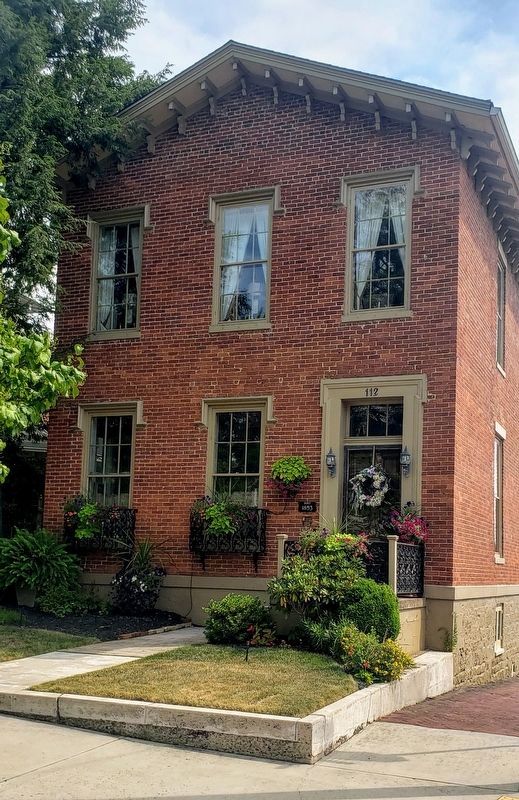
On Washington Street at South Smallwood Street, on the right when traveling east on Washington Street.
19th Century Greek
Revival Home
Built 1853
Shields Residence
National Register
Historic Places
Washington Street
Historic District — — Map (db m179062) HM
On Washington Street east of Spruce Place, on the right when traveling east.
Circa 1869
National Register
Historic Places
Washington Street
Historic District
208 Washington Street
Mary Susan Cerutti
Historic Preservation Award
2015
Presented by the Cumberland Historic Preservation . . . — — Map (db m187071) HM
Near Washington Street west of North Allegany Street, on the right when traveling west.
Amick House
Built Circa 1905
Cumberland
Architect
George Sansbury
National Register
Historic Places
Washington Street
Historic District — — Map (db m180182) HM
Near Canal Street, 0.1 miles west of Wineow Street.
The Cumberland is a full scale replica canal boat, measuring approximately 93 feet long and 14.5 feet wide. It was constructed in 1976 as a Bicentennial project the C&O Canal of Cumberland, Maryland, Inc. (COCCM), a non-profit organization . . . — — Map (db m140080) HM
On Baltimore Street just east of Cumberland Street, on the left when traveling east.
Algonquian Hotel
has been placed on the
National Register
of Historic Places
by the United States
Department of the Interior
Circa 1926
— — Map (db m139109) HM
On North Centre Street at Market Street, on the right when traveling west on North Centre Street.
A log chapel dedicated to St. Mary was built on this site in 1791. The first parishioners were mostly English Catholics from Southern Maryland. A brick church replaced the log building in 1939. Cumberland became a major center of transportation and . . . — — Map (db m134394) HM
On Bedford Street, on the right when traveling north.
Dedicated on November 16, 2005
in honor of Nick Giarritta
"Cumberland's Renaissance Man"
on his 80th birthday
The city of Cumberland and its citizens
proudly recognize Dr. Nick Giarraita for being
a catalyst in preserving the architecture . . . — — Map (db m204081) HM
The First National Bank and Trust Company of Western Maryland was originally chartered as the Cumberland Bank of Alleghany by an act of the 1811 Maryland Legislature and opened for business April 1, 1812. this is the oldest bank in Western . . . — — Map (db m19337) HM
On North Centre Street, on the right when traveling north.
To all
who visit the
Centre Street Parklet.
Originally known
as "Maze” Parklet,
this public space was
created in 1976.
In 2018,
the storefront from
the Malamphy Tavern
that formerly stood at
the corner of Park and
Williams Street . . . — — Map (db m204088) HM
On Braddock Street (Maryland Route 736) west of Park Avenue, on the right when traveling west.
In 1968, Fuller House was acquired by the college. This building is the former residence of William Fuller, grandson of one of Old Main's builders. — — Map (db m134387) HM
The Potomac River meanders through six miles of bends here with steep cliffs dropping to the river, making the digging of a ditch canal nearly impossible. The canal company could have followed a natural fold (1) in the rock stratification to . . . — — Map (db m140022) HM
Near Trimble Road Northwest, 0.6 miles east of Slabtown Road Northwest, on the right when traveling east.
Built circa 1780, the Federal Hill / Evergreen Barn is a well-preserved example of a stone foundation Pennsylvania or Sweitzer Style Barn. It is built into the side of the hill to allow access on both levels. Hand-hewn logs create a cantilevered . . . — — Map (db m177944) HM
On Trimble Road Northwest, 0.6 miles east of Slabtown Road Northwest, on the left when traveling east.
The historic Federal Hill / Evergreen House was built in stages, beginning circa 1780 with a log/frame house built by Edward Grimes. Circa 1822, George Winter added onto the front porch of the Grimes' house, which faced
southward toward the Barn, . . . — — Map (db m178468) HM
On Geary Lane north of Jealous Row, on the right when traveling north.
This property
The Castle
has been placed on the
National Register
of Historic Places
by the United States
Department of the Interior — — Map (db m134390) HM
On Main Street east of Conduit Street, on the right when traveling east.
This commercial structure was one of several built between 1908-1913 after a fire destroyed the City Hotel. Merchant James F. Strange had the building constructed during his ownership. The building has remained in the Strange Family and in retail . . . — — Map (db m114549) HM
The story of historic preservation in Annapolis is one of community involvement. Efforts to protect the historic element of Annapolis extend back to the nineteenth century. In . . . — — Map (db m114793) HM
The porch you see before you is a modern reconstruction of this principal entrance to the Carroll House. It was added to the house in the 1770s by Charles Carroll of Carrolton and removed by 1866 when a two story passage was built between St. Mary's . . . — — Map (db m175948) HM
On Duke of Gloucester Street, on the left when traveling south.
Has been designated a Registered National Historic Landmark Under the provisions of the Historic Sites Act of August 21, 1935. This site possesses exceptional value in commemorating or illustrating the history of the United States U.S. . . . — — Map (db m6199) HM
Beyond Main Street: As you travel up Main Street from the City Dock, looking up from Francis Street to your right you see one of the iconic views of Annapolis—the Maryland State House. Built in the late 18th century atop the hill crowned by State . . . — — Map (db m114552) HM
On Maryland Avenue near King George Street, on the right when traveling north. Reported permanently removed.
Designed and built for legislator and patriot, Mathias Hammond by the colonial architect, William Buckland, this beautiful residence is considered the pinnacle of the Georgian Style in America.
A museum today, the house is almost entirely . . . — — Map (db m7898) HM
On Maryland Avenue just south of Cumberland Court, on the right when traveling south.
Tours start at the top of the hour from noon until 4:00 (summer) or 3:00 (winter).
Built in 1774 by renowned architect William Buckland for tobacco planter and patriot Matthias Hammond, the house is one of the finest examples of . . . — — Map (db m142372) HM
On Pinckney Street, 0 miles north of Market Street, on the right when traveling north.
One of the oldest surviving houses in Annapolis, Shiplap House served as a store and tavern in the eighteenth century. The house is named for the random-width flush siding (called shiplap) on the rear facade and northeast ell. The building now . . . — — Map (db m17690) HM
On Market Space south of Fleet Street, on the right when traveling north.
The current Market House is the third to be built on this site. In 1784, Nicholas Carroll, Jacob Hurst, Charles Wallace, Joseph Williams, Thomas Harwood, John Davidson, James MacKubin and James Williams, all prominent businessmen, donated the land . . . — — Map (db m114795) HM
On Baltimore Boulevard (Maryland Route 450) east of King George Drive (Maryland Route 450), on the right when traveling west.
Built 1774 by Matthias Hammond, local patriot
Designed by William Buckland, Colonial Architect
18th Century furnishings
One of America's famous houses
Open to the public — — Map (db m127929) HM
Near Mansion Ridge Road, 0.1 miles east of Mansion Woods Road, on the right when traveling east.
Iglehart
1708 Mansion Ridge Road
is listed on
National Register
of Historic Places
by the United States
Department of the Interior
c. 1811
— — Map (db m142375) HM
Near Londontown Road, 1.3 miles east of Mayo Road (Route 253).
Has been designated a Registered National Historic Landmark under the provisions of the Historic Sites Act of August 21, 1935. This site possesses exceptional value in commemorating or illustrating the history of the United States. — — Map (db m3420) HM
On Llewellyn Avenue at Roberts Avenue, on the right when traveling west on Llewellyn Avenue.
In 1934, Hodges Hall was built as the post headquarters. From its position on the south end of the post parade ground, it offered an impressive view of events. The design of the building mirrors the central block of Doughoregan Manor, the home of . . . — — Map (db m19686) HM
On Huber Road at Ernie Pyle Street, on the right when traveling north on Huber Road.
In compliance with instructions contained in a letter from Adjutant General of the Army, dated March 17, 1924, a School for Bakers and Cooks was established at Camp Meade in April of that year. Throughout its existence at the post, the school's . . . — — Map (db m19702) HM
Near Kinder Farm Park Road, 0.4 miles west of Jumpers Hole Road when traveling west. Reported permanently removed.
Restoration of the exterior and the interior first floor of this building to represent a typical late 1930s, early 1940s Anne Arundel County farmhouse.
The farmhouse was built around 1925 by Henry Kinder and his wife Hilda (Yanke). The first . . . — — Map (db m99089) HM
On Odenton Road at Morgan Road, on the right when traveling east on Odenton Road.
Only known World War I chapel in the United States. Consecrated in 1918 to minister to the soldiers at Camp Meade and serve as permanent mission in the village of Odenton. Designed in the Arts and Crafts style by Riggin Buckler. Used by all . . . — — Map (db m3162) HM
Near Chesapeake Bay Drive at John Downs Loop, on the right when traveling west.
During the period 1913 to 1937 this property was the summer estate of H.R. Mayo Thom. In Mother's Garden was this thatched roof gazebo. The gazebo was built by Reginald Giddings, a handyman who worked or the Thoms. Mr. Giddings was an Englishman . . . — — Map (db m147654) HM
In 1889, business partners Gustav T. Hetschel and Henry Frost established a general store and post office just steps away from the Annapolis and Baltimore Short Line Railroad. This new rail service connected the state's economic and political . . . — — Map (db m239533) HM
On East 33rd Street at Greenmount Avenue (Maryland Route 45), in the median on East 33rd Street.
In 1911, construction of East 33rd Street and The Alameda began to create the "Olmsted Parkways" — tree-lined boulevards that would connect a ring of parks around the city.
The parkways were designed and named after Frederick Law . . . — — Map (db m226273) HM
Archibald Coleman Rogers, FAIA 1917-2001
Founding Partner of the global architectural firm RTKL. President of the American Institute of Architects. First Executive Director of the Greater Baltimore Committee. He played a vital role in revitalizing . . . — — Map (db m142896) HM
On O’Donnell Street at Potomac Street, in the median on O’Donnell Street.
Through the efforts of the Canton Improvement Association this old and densely populated ethnic neighborhood was named to the National Register of Historic Places in 1978. The two-story red brick row houses are especially noteworthy for their hand . . . — — Map (db m184476) HM
Near North Charles Street north of West Oliver Street, on the right when traveling north.
Pennsylvania Station dates from the Gilded Age of architecture, when railroads were the economic force of the city and train stations were monuments of civic pride. This station, designed by Kenneth M. Murchison, opened the night of September 14, . . . — — Map (db m135066) HM
On Indian Head Drive just east of St. Lo Drive, on the left when traveling east.
Clifton Mansion was the summer residence of Quaker merchant Johns Hopkins. In founding the Johns Hopkins University, Hospital, and Medical School, Hopkins transformed higher education, medicine, and the City of Baltimore. He became the first . . . — — Map (db m189862) HM
On South Eutaw Street at West Lombard Street (U.S. 40), on the right when traveling north on South Eutaw Street.
Once known as the Bromo Seltzer Tower, this building is a monument to Captain Isaac Emerson, the imaginative chemist who developed a famous headache remedy, and named it after Mt. Bromo - an active volcano in Java.
Emerson came to Baltimore in . . . — — Map (db m6982) HM
On Water Street east of Commerce Street, on the left when traveling east.
Until the 1850's, Baltimore's grain trading took place in "counting rooms" of individual merchants or on Bowley's Wharf where an effort was made to standardize corn and grain prices by displaying grain samples on barrel heads and window ledges. . . . — — Map (db m127236) HM
On North Calvert Street at Lafayette Street, on the left when traveling north on North Calvert Street.
This “noble pile” as it was described at the dedication of January 8, 1900, is the third courthouse built on Monument Square. When Calvert Street was leveled in 1784, the original courthouse—site of the May 1774 Stamp Act Protest . . . — — Map (db m89370) HM
On Cathedral Street at West Mulberry Street (U.S. 40), on the left when traveling south on Cathedral Street.
Has been designated a National Historic Landmark.
This site possesses national significance in commemorating the history of the United States of America. — — Map (db m5787) HM
On North Charles Street, on the left when traveling north.
Named for the governor who developed it, Brown's Arcade is a unique and early example of adaptive reuse in Baltimore. The four buildings that make up the Arcade were originally constructed as rowhouses in the 1820's. After the Great Fire of 1904, . . . — — Map (db m5565) HM
On North Charles Street at East Baltimore Street on North Charles Street.
Twice in the 20th century, Baltimoreans completely reinvented their downtown-by necessity in the early 1900s and by plan mid-century.
In 1904, Baltimore’s downtown vanished when 140 acres were destroyed by fire. Within ten years, Baltimore had . . . — — Map (db m103262) HM
On Commerce Street south of Holliday Street, on the left when traveling south.
Built between 1904 and 1905, this Renaissance Revival building was once the commercial hub of Baltimore's grain trade. Standing five-stories tall and extending the length of a city block, the building was home to the Baltimore Chamber of Commerce, . . . — — Map (db m127235) HM
On North Charles Street at West Lexington Street when traveling south on North Charles Street.
The 14-block Charles Center project, begun in 1958, was the first piece of Baltimore's nationally recognized downtown Renaissance. the 33-acre project was strategically placed between the financial district on the east side and the retail . . . — — Map (db m88236) HM
When City Hall was completed in 1875, it was admired as a marvel of style, elegance and technology. The Second Empire design was the first commission of 22-year old George Frederick. Wendel Bollman, a Baltimore engineer, designed the 227-foot high . . . — — Map (db m102322) HM
On North Calvert Street (Maryland Route 2), on the right when traveling north on North Calvert Street.
The Continental Trust Building, constructed in 1902, is the only building in Baltimore designed by Daniel H. Burnham, a major figure in the Commercial Style that developed in Chicago at the turn of the century and produced the American skyscraper. . . . — — Map (db m6442) HM
On Cathedral Street at Mulberry Street on Cathedral Street.
During the early 19th century, Baltimore became, for a brief time, America’s second largest and fastest growing city. Baltimore led the world in shipbuilding, sail-cloth production, and flour milling. On Cathedral Hill, Baltimore’s business leaders . . . — — Map (db m107314) HM
On East Baltimore Street at South Calvert Street on East Baltimore Street.
Baltimore’s central business district has constantly reinvented itself in response to changes in building technologies, business practices, and architectural styles. Originally,
detached houses that doubled as shops and offices lined the streets. . . . — — Map (db m103260) HM
On Cathedral Street just north of West Mulberry Street. Reported permanently removed.
In 1882, the merchant Enoch Pratt, wishing to make a gift to his adopted city which would benefit all of her citizens, gave Baltimore $1,058,000 to establish a public library.
The original building fronted on Mulberry Street. Designed by the . . . — — Map (db m166958) HM
When constructed in 1870, the Faust Brothers Building incorporated the latest innovations in building construction methods and materials. The building’s intricate front and rear facades, composed entirely in cast iron, were once common in . . . — — Map (db m101784) HM
Baltimore's first fish market stood near the site of this structure as searly as 1773. The first market building, Centre Market, was authorized by act of the State legislature in 1784. It was also known as Marsh Market since it was built on Thomas . . . — — Map (db m7322) HM
On North Calvert Street (Maryland Route 2), on the right when traveling north.
This structure, designed by James A. Wetmore and completed in 1932, is the second post office to occupy this site. Erected at a cost of $3.3 million, the neo-classical building, with its marble halls and paneled court-rooms, contained the most . . . — — Map (db m6160) HM
On North Charles Street just south of East Saratoga Street, on the right when traveling north. Reported permanently removed.
St. Paul's Church (Episcopal) stands on the only property that has remained under the same ownership since the original survey of Baltimore Town in 1730. In that year, Lot. No. 19, the highest point in the new town, was granted to St. Paul's . . . — — Map (db m166953) HM
On North Howard Street at West Saratoga Street, on the left when traveling north on North Howard Street.
This imposing building, appropriately designed by Joseph Evans Sperry to suggest an old treasure chest, is the home of Provident Savings bank, the father of branch banking among mutual savings banks of the nation. Incorporated in 1886 with the . . . — — Map (db m6653) HM
On South Calvert Street (Route 2) at East Baltimore Street, on the left when traveling north on South Calvert Street.
This building was home to Alexander Brown & Sons Company, founded in 1800 as the first investment banking firm in the United States. Douglas Thomas designed the building in the popular Beaux-Arts style and the building was constructed in 1901. It . . . — — Map (db m183359) HM
On North Calvert Street (Maryland Route 2) at East Fayette Street, in the median on North Calvert Street.
Built 1815-1825 to commemorate those who fell in the British attack on Baltimore in September 1814, the Battle Monument stands on the site of Baltimore’s first courthouse. When Calvert Street was leveled in 1784, the courthouse was raised on an . . . — — Map (db m237126) HM
On North Calvert Street (Maryland Route 2) at East Fayette Street, on the left when traveling north on North Calvert Street. Reported permanently removed.
This building, designed in 1889 in the Richardson-Sullivan tradition by Charles L. Carson and Joseph Evans Sperry, was considered the first skyscraper to be erected in Baltimore. It is the oldest of the existing structures on Monument Square and . . . — — Map (db m6443) HM
On North Calvert Street (Maryland Route 2) at East Fayette Street, on the left when traveling north on North Calvert Street.
The Equitable Building, designed in 1889 in the Richard-son-Sullivan tradition by Charles L. Carson and Joseph Evans Sperry, was considered the first skyscraper to be erected in Baltimore. It is the oldest of the existing structures in . . . — — Map (db m232408) HM
On East Redwood Street at South Street, on the left when traveling west on East Redwood Street.
This 13-story building, completed in 1913, was designed by Baltimore architects J. B. Noel Wyatt and William G. Nolting. Reflecting a mixture of styles, this transitional building combines the Chicago windows, flat wall panes and flat skyline . . . — — Map (db m7040) HM
On Lexington Street at Calvert Street on Lexington Street.
Rising ten stories in the heart of the city’s judiciary district, the Lenore not only exhibits impressive architecture but is also linked to the nation’s banking history. Now an apartment building, the Lenore was once home to the Baltimore Branch . . . — — Map (db m101527) HM
This house was built by Rembrandt Peale in 1814 as a Natural History Museum and Gallery of the Fine Arts. Robert Carey Long was the Architect. Purchased by the City of Baltimore, 1830, Jacob Small being Mayor, it was occupied as the City Hall from . . . — — Map (db m6307) HM
On South Calvert Street (Maryland Route 2) at East Fayette Street, on the right when traveling north on South Calvert Street.
When this structure was completed in 1911, it was Baltimore's tallest office building. Of steel construction, faced with Bedford limestone on the lower floors, and brick and terra cotta above, the building stands as a monument of sorts to the whims . . . — — Map (db m7319) HM
On East Lexington Street, on the right when traveling east.
"It is a fearful thing to lead this great, peaceful people into war, into the most terrible and disastrous of all wars, civilization itself seeming to be in the balance. But the right is more precious than the peace, and we shall fight . . . — — Map (db m6294) HM
Near Safari Place, 0.2 miles north of Beechwood Drive, on the right when traveling north.
The Main Valley is the oldest section of the Maryland Zoo, formerly known as the Baltimore Zoo. Now antiquated, overgrown, and mostly vacant, it is where the small, informal zoo at the center of Druid Hill Park began in the mid-19th century. . . . — — Map (db m189032) HM
The striking architecture of Baltimore’s original Dunbar High School complements the school’s role in community empowerment and educational equality. Dunbar’s educators, students, and alumni worked to achieve the “equal” in the “separate but equal” . . . — — Map (db m101610) HM
On Warren Avenue just east of William Street, on the left when traveling east.
This property is listed on the National Register [of Historic Places]
as part of
Federal Hill
National Historic District
and is registered with the
Preservation Society
1850 — — Map (db m189874) HM
On William Street just north of East Churchill Street, on the right when traveling north.
This property is listed on the National Register [of Historic Places]
as part of
Federal Hill
National Historic District
and is registered with the
Preservation Society
1857 — — Map (db m189937) HM
In the early 1780s Ann Bond Fell Giles laid out for development the area called Fell's Point, just south of the existing Fell's Prospect community. Development was in part to provide housing needed to meet the demands of the growing maritime . . . — — Map (db m109369) HM
To escape the intolerable heat of Baltimore summers, Thomas Dekay Winans built this country house on land which he had purchased in 1855. Winans had recently returned from Russia, where he made a fortune supervising construction of the . . . — — Map (db m6404) HM
In the mid-1800s this meadow and hillside were part of Thomas Winans' country estate, the Crimea. After returning from Russia, where he helped build the St. Petersburg-Moscow railroad, Winans established this estate. He and his Russian-born wife, . . . — — Map (db m6336) HM
On Eagle Drive, 0.2 miles south of Windsor Mill Road, on the right when traveling south.
"One of the most beautiful, as well as extensive country seats in the vicinity of Baltimore is that of the late Thomas Winans."
"A Day at the Crimea," Baltimore Herald (1894)
On North Franklintown Road. Reported permanently removed.
Orianda House, built in 1857 at a cost of $9,170.69, was designed by Niernsee and Neilson, architects. This country mansion was the summer home of Thomas de Kay Winans, a wealthy railroad entrepreneur, and his Russian-born wife, Celeste Louise . . . — — Map (db m61050) HM
On Eagle Drive, 0.4 miles south of Windsor Mill Road, on the right when traveling east.
Orianda House, built in 1857 at a cost of $9,170.69, was designed by Niernsee and Neilson, architects. This country mansion was the summer home of Thomas de Kay Winans, a wealthy railroad entrepreneur, and his Russian-born wife, Celeste Louise . . . — — Map (db m212884) HM
On North Broadway, 0.2 miles north of E Madison St., on the left when traveling north.
This plaque commemorates the site of Broadway School (Public School 109). The building was designed by prominent Baltimore architect Francis E. Davis and constructed in 1876. An example of the innovative "open plan" developed by J. J. Husband for . . . — — Map (db m224364) HM
The Perkins Square Gazebo harkens back to the grandeur of Baltimore’s 19th century architectural and landscape heritage. In 1871, the gazebo was built as a spring shelter, the centerpiece for a new park. The land for the park was once part of . . . — — Map (db m101927) HM
On Herring Run Trail, 0.5 miles Belair Road, on the right when traveling west.
Home of a Founding U.S. Congressman
William Smith was born in 1728 in Lancaster County, Pennsylvania. He became a successful merchant, and moved to Baltimore in 1761 to expand his shipping business. At the time, revolutionary feelings were . . . — — Map (db m153967) HM
On West Baltimore Street just west of South Martin Luther King Jr. Boulevard, on the left when traveling west.
This land was once the magnificent estate of Thomas Dekay Winans, an engineer who made a fortune during the 1840's supervising the construction of the first Russian transcontinental railroad. The engineer named his estate "Alexandroffsky," in . . . — — Map (db m166997) HM
On East Pratt Street at Light Street (Maryland Route 2), on the left when traveling east on East Pratt Street.
Just north of the Inner Harbor is Downtown's municipal, business and financial district, also referred to as City Center, a prime east coast location for corporate headquarters and financial institutions.
City Center's most pervasive . . . — — Map (db m115210) HM
On South Hanover Street at West Lombard Street, on the right when traveling south on South Hanover Street.
The colorful dynamic form of Baltimore Federal was inspired by the elaborate and extravagant shapes of Baroque sculpture of the 17th century. The bright, vibrant colors and intertwining pieces of the sculpture invite the viewer to interact . . . — — Map (db m219703) HM
On Harbor Bridge Walk, 0.1 miles south of East Pratt Street, on the right when traveling south.
US Coast Guard Cutter, Taney, the only warship still afloat that saw action during the December 7, 1941 attack on Pearl Harbor, was commissioned in 1936. This 326-foot High Endurance Cutter is one of seven Secretary class ships built. . . . — — Map (db m145465) HM
427 entries matched your criteria. The first 100 are listed above. Next 100 ⊳