On North Center Avenue (Pennsylvania Route 601) at East Union Street, on the right when traveling north on North Center Avenue.
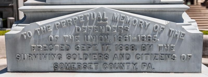
To the perpetual memory of the defenders of the Union, 1861–1865. Erected Sept. 17, 1888, by the surviving soldiers and citizens of Somerset County, Pa.
Grand Army of the Republic 1861–1866 Veterans, R.P. Cummins Post No. 201, Dept, Pa.
— . . . — — Map (db m199554) WM
On North Center Avenue (Pennsylvania Route 601) at North Pleasant Avenue, on the left when traveling south on North Center Avenue.
This fountain and the adjoining Gilmour Bypass are dedicated in memory of Robert A. Gilmour by his widow, Romaine Lohr Gilmour. Mr. Gilmour, born October 14, 1896, in Vintondale, Cambria County, Pennsylvania, came to Somerset Borough in 1926 and . . . — — Map (db m220327) HM
Near Mt. Davis Road 0.1 miles west of North Wolf Rock Road, on the right when traveling west.
Henry Baughman — an ill-tempered man — and his two sons were searching the fields for lost cows. The father became angry with his youngest son, August, who was slowing the search. The father struck him with a stick, knocking him unconscious. Henry, . . . — — Map (db m142992) HM
On Glades Pike (Pennsylvania Route 31) 0.1 miles east of Brotherton Road ( Route 1005), on the left when traveling east.
One of Pennsylvania's most noted jurists and lawyers, was born here Jan. 10, 1810. State Supreme Court Justice, 1851-57; U.S. Attorney-General, 1857-60. Later life spent at York as a famous lawyer. Died Aug. 19, 1883. — — Map (db m21556) HM
On County Route 77 at County Route 366, on the right when traveling north on County Route 77.
The Pioneer Barn is so-called because of its design, not its age. The 48 foot by 36 foot-barn houses the Eash & Yoder Conestoga Wagon and related artifacts of the pioneer era. Using an 1840-era Pennsylvania barn style (also known as German barn . . . — — Map (db m281151) HM
On County Road 114 0.1 miles west of State Route 39, on the right when traveling west.
Jonas Stutzman, from Somerset County, Pennsylvania, came to this site in 1809 to clear land for farming and to build a log home for his family. He was the first permanent settler in the eastern portion of what would in 1825 become Holmes County. . . . — — Map (db m24493) HM
On Main Street east of 8th Street, on the right when traveling east.
Around a potbellied stove one blustery winter night in 1948, plans were formulated for Meyersdale's first Maple Festival that celebrates and promotes the sweetest of all Pennsylvania's commodities-Somerset County maple syrup.
The first . . . — — Map (db m199946) HM
The 142nd Pennsylvania Volunteer Infantry, commanded by Colonel Robert Parson Cummins, former Somerset County Sheriff, enrolled 935 officers and men in 1862. Companies C, D & F were raised in Somerset County. The regiment took part in over twenty . . . — — Map (db m23097) HM
Near Mt. Davis Road 0.6 miles south of S. Wolf Rock Road when traveling south.
John Nelson Davis for whom Mt. Davis, Pa. is named was an early community leader in Southern Somerset County. He was a surveyor, school teacher, Superintendent of Schools for Elk Lick Township, Pa., and ordained minister, shook maker, farmer and . . . — — Map (db m8283) HM
Two-Story Log House
This typical German Settler's log house was owned by Adam Miller prior to 1798 and located on a tract of land called "Paradise," about 10 miles from the Historical Center. It was moved to this site in 1954. The 1798 . . . — — Map (db m234545) HM
On East Pitt Street at Clark Building Road, on the right when traveling east on East Pitt Street.
In 1936 seventy-five percent of Pennsylvania farms had no electric service. During the next five years, with Federal support, 14 consumer-owned cooperatives were formed in this State. Bedford Rural Electric Cooperative, which serves members in . . . — — Map (db m52665) HM
On Utah Route 91, on the right when traveling north.
In 1859, after helping settle San Bernardino California, Moses Harris moved his family to Utah and settled on the Virgin River near Quail Creek. In 1862 a flood forced the settlers further up Quail Creek to the Cottonwood Creek Fork. Due to the many . . . — — Map (db m85128) HM
On South Confederate Avenue at Warren Avenue, on the right when traveling north on South Confederate Avenue.
(Front):10th Pennsylvania Reserves 39th Penna. Infantry 3d Brigade 3d Division 5th Corps July 2d occupied this line of stone fence and remained from 5 p.m. until close of the battle. Present at Gettysburg 28 officers 392 men Killed 2 men . . . — — Map (db m17780) HM WM
Original Location
The Walter's Mill Covered Bridge was originally located over Coxes Creek, 4 miles south of Somerset. It was replaced by the Pennsylvania Department of Highways with a concrete bridge in 1961. At that time, the bridge was . . . — — Map (db m231092) HM
Near Main Street east of 8th Street, on the left when traveling east.
■ When the Baltimore & Ohio Railroad came through the Casselman River valley in 1871, Meyersdale already was a prosperous town. Founded by German settlers in the late 1700s, Meyers Mill became Meyersdale in 1874 and was an important . . . — — Map (db m202262) HM
On West River Street at River Street, on the right when traveling north on West River Street.
[ south side ]
Milford Remembers
New York City
Erected by the People of Milford, Connecticut in memory of the innocent victims of the terrorist attacks on the World Trade Center in New York City on September 11, 2001. With special . . . — — Map (db m26336) HM
On Union Street at Center Street (Pennsylvania Route 601), on the left when traveling east on Union Street.
Serving as the county seat of Somerset County this court house sits at elevation of 2,190 feet above sea level making it the highest county seat in Pennsylvania. The copper-sheathed dome rises 135-feet above the street making it visible . . . — — Map (db m199574) HM
On Collinsburg Road, on the right when traveling south.
There has been a river crossing here since the days of
the Native Americans. The original trail, called the
Glades Path, was widened about 1772. becoming the
Glades Road or the Great Road, connecting Bedford
to Washington, Pennsylvania, Westward . . . — — Map (db m204263) HM
The Story of the Heroes of Flight 93
The events of September 11th, 2001 are forever etched into the hearts of the family members and loved ones of those who died, the Nation and the world. The United States experienced the worst incident of . . . — — Map (db m26392) HM WM
On West Illinois Avenue at Liberty Street, on the right when traveling east on West Illinois Avenue.
[panel 1] "...How sweet the recollection, when my children were about me, then I felt I had protection, and no one dared to flout me." Elsie Armstrong wrote an epic poem that records the tragic deaths of four children. It . . . — — Map (db m233211) HM
On Center Street at Main Street, on the right when traveling north on Center Street.
Meyersdale
continues to
celebrate its
rich history
and small
town charm.
Named for early settler
Peter Meyers, "The Maple
City" became a bustling
transportation hub. As industry
faded, Meyersdale adapted.
This former railroad . . . — — Map (db m282638) HM
Near Lincoln Highway (U.S. 30) 0.2 miles west of Johnson Bottom Road (Local Route 730), on the right when traveling west.
Born August 3, 1986 to Nils and Frances (nee Kamienowski) Thompson. He was a deeply religious Catholic and Christian, a Staten Island native who grew up playing with GI Joes. He dreamt of joining the military as a young boy as his grandfather, . . . — — Map (db m303446) HM WM
Near Lincoln Highway (U.S. 30) 0.2 miles west of Johnson Bottom Road (Local Route 730), on the right when traveling west.
SSgt Brian Hause was born in Somerset, Pennsylvania, to Kathy Levernight Hause, on June 16th 1979. Brian graduated from Johnstown Christian School, Hollsopple, PA. It was his selfless love of family and country that motivated him to enlist in the . . . — — Map (db m303444) HM WM
Near Skyline Road (via Stauffer Road) 1 mile south of Lincoln Highway (U.S. 30).
Panel 1:
America Attacked
On the morning of September 11, 2001, al-Qaeda terrorists hijack four commercial U.S. airliners that are departing from East Coast airports. The terrorists fly two jet airliners into the World Trade . . . — — Map (db m49256) HM WM
The Connellsville Extension from Cumberland Financier George Gould purchased the Western Maryland as part of a transcontinental railroad scheme that would stretch from Baltimore to San Francisco. Gould extended the WM west to Cumberland, but . . . — — Map (db m4688) HM
Minutes after the crash, first responders arrive on the scene, along with the Pennsylvania State Police. The September 11 attacks generate the largest investigation in FBI history. The primary goal of the investigation is to recover sufficient . . . — — Map (db m100697) HM WM
In memory and honor of those Texans who perished in the tragic events of September 11, 2001 and the brave Texas heroes of Operation Enduring Freedom.
8:45 AM Panel
World Trade Center North Tower
American Airlines Flight 11 . . . — — Map (db m212226) HM WM
September 11, 2001
"In this time of our nation's great sorrow, may
we look up to heaven while we stand with
heads raised to view our flag. This will
lighten our hearts, in awareness of all that
has been given to us from those who have
passed . . . — — Map (db m293253) WM
Near Newport Road, on the right when traveling north.
"On my honor I will do my best to do my duty to God and my country and to obey the Scout Law"
In 1928, the Boy Scouts of America purchased 287 acres of land at a cost of $10,000 from the estate of Edward Pierson (died 1922) for the . . . — — Map (db m37073) HM
In honor of all angry hearts and wounded souls
who came together to honor the dead
and fight for our freedom
The three columns symbolize the three locations of 9-11-2001.
The nest of twisted metal the ability of our country
to use . . . — — Map (db m215257) WM
On Rockdale Road at Markleton School Road, on the right when traveling south on Rockdale Road.
Maynard R. Sembower watched the construction of the Western Maryland Railway, rode it as a child and an adult, saw it through its final days of passenger and freight traffic and was delighted to see its right-of-way reborn as a rail-trail. . . . — — Map (db m229702) HM
On East Main Street, on the right when traveling east.
This log frame home is considered
the oldest in town. Harmon Husband,
the first permanent settler in Somerset,
originally occupied the property.
Husband, a pioneer, farmer,
pamphleteer, politician, and surveyor,
is remembered as a hero of both . . . — — Map (db m203956) HM
On Wilson Boulevard west of North Hudson Street, on the left when traveling west.
Arlington in the New Millennium
In 2000 Arlington's population had risen to more than 189,000, which would grow by another 18,000 by 2010, an increase greater than the entire County population at the outbreak of World War I (WWI). At . . . — — Map (db m236020) HM
On West Street (Virginia Route 705) at U.S. 29, on the right when traveling south on West Street.
We will never forget.
This monument stands in memory of those who lost their lives as a result of the terrorist attacks on September 11, 2001.
On the morning of September 11, 2001, four planes departed from east coast cities, three . . . — — Map (db m145015) HM WM
Thin black lines indicate changes in relevance. Between each pair of lines entries are ordered geographically but all have the same relevance.
* Inflectional forms of words are their plurals, singulars, and possessives as well as gramatical tenses and similar variations.