Near Interstate 20 (Interstate 20) west of Alabama Route 37, on the right when traveling west.
The De Soto Trail
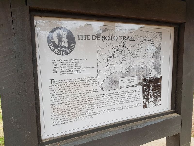
Hernando De Soto in Alabama
Hernando de Soto brought his 700-man army to Alabama in the fall of 1540. This was the first major European expedition to the interior of the southeastern United States. The De Soto . . . — — Map (db m114373) HM
On U.S. 84 at County Road 1, on the left when traveling west on U.S. 84.
The Alabama home of the commander of the Alamo. While living in this house Travis read law under The Hon. James Dellet of Claiborne, Al. In 1831, at the age of 22, he left Claiborne for Texas where he practiced law and became involved in the Texas . . . — — Map (db m47644) HM
When the Kiksadi clan of the Tlingit Indians first migrated into this area from the south, they chose this promontory for the erection of their main houses. There were four of these community houses here when Baranof, governor of the . . . — — Map (db m181334) HM
Commandant Inspector
of the
Interior Provinces of New Spain
Hugo O'Conor
Founder of the
Presidio San Agustin de Tucson
August 20, 1775
Hugh O'Conor was born in Ireland in 1734 during a time in Irish history when England . . . — — Map (db m31548) HM
On Virginia Street, on the left when traveling east.
Robert Hale Merriman, a UC Berkeley graduate student studying economics during the early 1930s, was among the first Americans to give his life in the fight against fascism. During the Spanish Civil War, Merriman was a commanding officer of the . . . — — Map (db m152785) HM
On Carson Street, 0.2 miles west of Interstate 405, on the right when traveling west.
Philippine national hero. Born
on 19 June 1861. Doctor, poet,
writer, educator, linguist, inventor.
Authored novels Noli Me Tangere
(1887) and El Filibusterismo (1891)
which bared colonial oppression
of the Filipinos. He . . . — — Map (db m235033) HM
On Los Angeles Street at North Alameda Street, on the right when traveling west on Los Angeles Street.
This replica of the “Bell of Dolores” was presented to the City of Los Angeles by the Republic of Mexico in 1968. This cherished relic of Mexican history represents not only Mexico’s bid for freedom, but also the beginning of democracy . . . — — Map (db m162015) HM
On Glendale Boulevard at Park Avenue, on the right when traveling north on Glendale Boulevard.
José Martí was a citizen of the Americas who fought for the concept of liberty and
brotherhood for all men, without distinction of race, social status, or religion. He was a
poet, writer, teacher, political revolutionary, and great patriot. . . . — — Map (db m229697) HM
Near Highland Avenue south of U.S. 101, on the right when traveling south.
Treasure hunters believe there is 20th-century loot hidden at the Bowl. Many have searched, but the treasure is still a mystery.
The legend of the Cahuenga Pass treasure begins in 1864 when, under Napoleon's rule, France invaded Mexico and . . . — — Map (db m129805) HM
Near Mission Road at Valley Boulevard, in the median.
Born in Anenecuilco and murdered in Chinameca, Morelos. General commander of the Ejercito Libertador del Centro y del Sur, throughout the 1910 Mexican Revolution. He led the farmers movement for taking the land on, by proclaiming the . . . — — Map (db m219192) HM
Near Mission Hills Road, 0.2 miles west of Indian Hills Road.
In the beginning was the land of Armenia and the kingdom of
Pakradouni, Ani.
And Ani became Volga. And Volga became Crimea. And Crimea
became Don. And Don became the Republic of Armenia.
And the Armenian became a citizen of the . . . — — Map (db m217685) HM
Near Mission Hills Road, 0.2 miles west of Indian Hills Road.
This carved Khatchkar (cross stone) was modeled
after the ancient Armenian grave stones of Armenia
and specially made in Armenia for the Ararat Home.
Donated by Dr. & Mrs. Vartkes Najarian
in memory of
the victims of the 1915 Armenian . . . — — Map (db m210483) HM
On 40th Place, 0.2 miles east of Central Avenue, on the left when traveling east.
First African American
to win the Nobel Peace Prize.
Built 1908. Declared 1976, Historic-Cultural Monument No. 159, City of Los Angeles, Cultural Heritage Commission, Cultural Affairs Department.
Built in 1908, this was the childhood . . . — — Map (db m174655) HM
On 6th Street at Park View Street, on the right when traveling east on 6th Street.
Erected in memory of the heroes of the glorious Hungarian Freedom Fight of 1956. A symbol of man’s yearning for freedom everywhere. — — Map (db m125328) WM
SIR FRANCIS DRAKE
Born in 1540, Sir Francis Drake went to sea at about age 12. After Spaniards attacked an English trading fleet, including his ship, at San Juan de Ullua in Mexico, Drake began raiding Spanish ships and coasts. In a . . . — — Map (db m153379) HM
On Warner Avenue at Ross Street, on the right when traveling east on Warner Avenue.
Dedicated to the memory of the brave men of the United States Armed Forces who lost their lives in the line of duty in Beirut, Lebanon. — — Map (db m212929) WM
Near T Street west of 8th Street, on the left when traveling west.
Miguel Hidalgo y Costilla (1753-1811) Father of Mexico His battle cry for freedom on September 16, 1810 led Mexico to indenpendence from Spain and the end of colonialism. Statue donated by Alberto and Carmencita Heredia, and family, . . . — — Map (db m137649) WM
On Dolores Street at 19th Street, on the right when traveling south on Dolores Street.
On the early morning of Sunday September 16th.; A.D. 1810, Miguel Hidalgo y Costilla rang the bell of his church in the town of Dolores, in the now state of Guanajuato, calling the people to mass and to bear arms against the . . . — — Map (db m162986) HM
In 1849 chickens were scarce in San Francisco. The Pacific Egg Company was formed and sailed to the farallon "Devil's Teeth" Islands, just 30 miles outside the Golden Gate, with the dangerous job of collecting sea bird eggs. These eggs would be . . . — — Map (db m241705) HM
On N. Center Street near W. Fremont Street, on the left when traveling south.
En conmemoración del Bicentenario de la Independencia de México y el Centenario de la Revolución mexicana, el Gobierno de México, a través del Consulado General de México en Sacramento, con el invaluable apoyo de la Asociación Comerciantes Unidos, . . . — — Map (db m103034) HM
Shivaji founded Pune (circa 1640). He was the first modern warrior who successfully fought the foreign invaders for 40 years and established a Maratha Kingdom that lasted 200 years with Pune as its Capital. — — Map (db m52492) HM
Charles Crist Kress died Oct. 10, 1913. Age 84, Native of Alsage-Lorraine. He spoke five languages , a veteran of the Crimean War, married in New York, came around the Horn to San Francisco. He owned a baker shop on Kearny St. In 1863 he bought 160 . . . — — Map (db m12988) HM
On Colorado 67 (at milepost 2) at County Road 19C, on the right when traveling south on Colorado 67. Reported unreadable.
The long battle between colonial Spain and the Comanche people climaxed in 1779, when Juan Batista de Anza's army killed the great chief Cuerno Verde (Green Horn) southeast of here at the foot of Greenhorn Mountain. De Anza, the governor of New . . . — — Map (db m219465) HM
Near Stadium Boulevard at North Gate Boulevard, on the right when traveling north.
Following a decisive military defeat of Iraq in the Persian Gulf War and
the fall of the Soviet Union in 1991, the United States remained as the
lone global power. U.S. political leaders struggled to determine the size
and role of its military . . . — — Map (db m232292) HM
Near Beach Road at Sunnieholm Drive, on the left when traveling west.
In memory
of
Thomas Sherwood
1586 – 1655
Puritan – Pioneer – Ancestor
A founder of New England
A first settler of Fairfield
Deputy to the General Court
Committeeman
Soldier of the Pequot War
and his wives . . . — — Map (db m27173) HM
Near Main Street (U.S. 44) at Chapel Street South, on the left when traveling north.
On June 5, 1798, Matthew Furlong was shot dead by Crown forces in New Ross as he approached the Three Bullet Gate carrying a flag of truce and a letter asking for the surrender of the town to the Rebel forces.
This monument serves to . . . — — Map (db m151919) HM
Near Temple Street, 0.1 miles south of Elm Street, on the right when traveling south.
In Memory of the Regicide
Col Edward Whalley
Son of Richard Whalley Esq a member of Parliament in the last days of Queen Elizabeth and first cousin of Oliver Cromwell. A stalwart Puritan he rose to high command in the Civil Wars. He was the . . . — — Map (db m34822) HM
Near Temple Street, 0.1 miles south of Elm Street, on the right when traveling south.
In Memory of the Regicide
Col William Goffe
A member of the High Court of Justice which in 1649 tried and condemned King Charles 1st of England and a signer of the kings death warrant. He served with distinction in the Parliamentary Army and in . . . — — Map (db m34817) HM
Near Wintergreen Avenue, 0.2 miles north of Brookside Avenue, on the left when traveling north.
Judges Cave
Here May Fifteenth 1661 and for some weeks thereafter Edward Whalley and his son-in-law William Goffe, members of the Parliament General, officers in the army of the Commonwealth and signers of the death warrant of King Charles First, . . . — — Map (db m34719) HM
On Dayett Mills Road south of Old Baltimore Pike, on the right when traveling south. Reported permanently removed.
[caption:] Iron ore like this was mined from Iron Hill and Chestnut Hill
What is iron ore?
Iron is a silvery-white, solid metal, though when found in Pencader Hundred, it commonly appears as a brown, and sometimes nearly black . . . — — Map (db m157343) HM
On Robert L. Melson Lane near Whitaker Road, on the left when traveling north.
[caption:] Iron ore like this was mined from Iron Hill and Chestnut Hill
What is iron ore?
Iron is a silvery-white, solid metal, though when found in Pencader Hundred, it commonly appears as a brown, and sometimes nearly black . . . — — Map (db m158219) HM
On Legion Road just east of John J Williams Highway (Delaware Route 5/24), on the left when traveling west.
The Patton Tank was too late for the Korean war but used in the Vietnam War by the United States Army & the United States Marine Corp and it was the last of the medium tanks made.
A total of 11,703 were made in many . . . — — Map (db m190351) HM
Near 14th Street Northeast just south of Quincy Street Northeast, on the right when traveling north.
This edifice is a replica of the Tomb of Mary. The Shrine as it appears today was constructed by the Crusaders in the 12th century. It is located just east of Jerusalem. — — Map (db m208439) HM
On Massachusetts Avenue Northwest at 17th Street Northwest, on the right when traveling east on Massachusetts Avenue Northwest.
Gran Almirante de Peru Miguel Grau 1834-1879 La República del Perú al Caballero de los Mares Inaugurado por el Presidente del Consejo de Ministros Salomón Lerner Ghitis y el Embajador del Perú en los Estados Unidos de América Harold . . . — — Map (db m97802) HM WM
On 20th Street Northwest north of Massachusetts Avenue Northwest, on the left when traveling north.
In memory of all the Hungarians who sacrificed their lives for freedom.
Mindazon magyarok emléké, akik életüket áldozták a szabadságért. — — Map (db m113913) WM
On 20th Street Northwest north of Massachusetts Avenue Northwest, on the left when traveling north.
'All for the people, all by the people,
nothing about the people without the people,
that is democracy.'
Spoken to the Ohio State Legislature on February 6, 1852
Lajos (Louis) Kossuth
Champion of Liberty, Fraternity, and . . . — — Map (db m113910) HM
On 20th Street Northwest north of Massachusetts Avenue Northwest, on the left when traveling north.
This house is dedicated
to the fraternal and cultural endeavors of freedom-loving Americans of Hungarian ancestry and to the
living memory of
Lajos (Louis) Kossuth
champion of liberty, fraternity, and equality, governor of . . . — — Map (db m113911) HM
On Rhode Island Avenue Northwest west of 15th Street Northwest, on the right when traveling east.
The Budapest Lad (Pesti Srac) statue was erected on October 16, 2016, in commemoration of the 60th Anniversary of the 1956 Hungarian Revolution and Freedom Fight.
The Embassy of Hungary gratefully acknowledges the generous support of the . . . — — Map (db m122532) HM WM
On Pennsylvania Avenue Northwest just west of 14th Street Northwest, in the median.
The American Expeditionary Forces were the soldiers and marines who fought on the Western Front in France and Belgium. But many other Americans served in the war.
While the United States initially remained neural, thousands of Americans . . . — — Map (db m171283) HM
On Virginia Avenue Northwest at 25th Street Northwest, on the right when traveling east on Virginia Avenue Northwest.
[Inscriptions, east face:]
Respect for the rights of others is peace Benito Juárez 1806-1872 The people of Mexico to the people of the United States of America El respeto al derecho ajeno es la paz Benito Juárez 1806-1872 El pueblo de . . . — — Map (db m82923) HM
On 18th Street Northwest at Virginia Avenue Northwest, on the left when traveling north on 18th Street Northwest.
[south face of pedestal]
Simón Bolívar
The Liberator
Born July 24, 1783
Caracas, Venezuela
Died December 17, 1830
Santa Marta, Colombia
[east face of pedestal]
The Republic of Venezuela to the . . . — — Map (db m65731) WM
On Connecticut Avenue Northwest south of Bancroft Place Northwest, on the right when traveling south.
Statesman, Leader and Forerunner of the Independence Movement in Latin America. Promoter of the economy and education, mentor of the principles of freedom that burst onto the Argentine early political scene in May 1810. An exemplary soldier, he . . . — — Map (db m74989) HM
Near U Street Northwest east of 14th Street Northwest, on the right when traveling west.
Paul travelled the world using his art as his weapon to fight against oppression and for self determination for all people. His home turf and land of his birth was not off limits as he marched with others to advance the cause of civil rights and . . . — — Map (db m112000) HM
On Bayfront Parkway at South Alcaniz Street, on the right when traveling east on Bayfront Parkway.
Military and naval conflict dominated the 18th century. France, Spain, and Great Britain were aggressors in nearly constant warfare that often extended into North America. Spain established a fledgling colony near what is now the Pensacola Naval Air . . . — — Map (db m130767) HM
Near U.S. 301, 0.2 miles East Dr. Martin Luther King Jr. Boulevard, on the right when traveling south.
The Boxer Rebellion, Boxer Uprising or Yihetuan Movement, was an anti-foreign, pro-nationalist movement by the Righteous Harmony Society in China between 1898 and 1901, opposing foreign imperialism and Christianity. The uprising took place . . . — — Map (db m194027) HM WM
Near U.S. 301, 0.2 miles south of East Dr. Martin Luther King Jr. Boulevard, on the right when traveling south.
National Liberation Front (FMLN) a coalition of five left-wing guerrilla groups. However this conflict evolved into a proxy war between the United States and the Communist elements of Nicaragua and Cuba. The United States was able to prevail by . . . — — Map (db m194165) HM WM
On South Ashley Drive at Channelside Drive, on the right when traveling north on South Ashley Drive. Reported missing.
Captain Joseph Fry was born in Tampa (Fort Brooke) June 14, 1826. As a graduate of the U.S. Naval Academy, he served with the Navy throughout the world. When the Civil War broke out, Fry fought with courage and capacity for the South in the . . . — — Map (db m129943) HM
Near U.S. 301, 0.2 miles south of East Dr. Martin Luther King Jr. Boulevard, on the right when traveling south.
In 1995 NATO bombing of Bosnia and Herzegovina (code named by NATO Operation Deliberate Force) was a sustained air campaign conducted by the North Atlantic Treaty Organization (NATO) to undermine the military capability of the Army of the . . . — — Map (db m193460) WM
Near U.S. 301, 0.2 miles south of East Dr. Martin Luther King Jr. Boulevard, on the right when traveling south.
Operation Deny Flight was a North Atlantic Treaty Organization (NATO) operation that began on 12 April 1993 as the enforcement of a United Nations (UN) no-fly zone over Bosnia and Herzegovina. The United Nations and NATO later expanded the . . . — — Map (db m193673) HM WM
Near U.S. 301, 0.2 miles south of East Dr. Martin Luther King Jr. Boulevard, on the right when traveling south.
In early March 1988, the Nicaraguan Sandinista government launched Operation Danto to overrun Contra rebel supply caches in the San Andrés de Bocay region, crossing into
Honduran territory in their drive.
The United States, under . . . — — Map (db m237445) WM
Near U.S. 301, 0.2 miles south of East Dr. Martin Luther King Jr. Boulevard, on the right when traveling south.
The United States set up Operation Provide Promise and, in cooperation with UNHCR and the World Food Programme (WFP), began airdropping relief supplies to parts of Bosnia - Herzegovina on 28 February 1993. By late November, more than 1,482 . . . — — Map (db m193723) HM WM
Near U.S. 301, 0.2 miles south of East Dr. Martin Luther King Jr. Boulevard.
The USS Liberty Incident was an attack on a United States Navy technical research ship, USS Liberty, by Israeli Air Force jet fighter aircraft and Israeli Navy motor torpedo boats, on 8 June 1967, during the Six-Day War. The combined air and sea . . . — — Map (db m193283) HM
On East 7th Avenue just east of North 20th Street, on the right when traveling east.
Side 1
On May 6, 1937, 5000 Latinas from Ybor City assembled here on 7th Avenue to protest the rise of fascism in Spain and around the world. They marched from Ybor city to downtown Tampa to address Mayor R.E.L. Chancey at City Hall. Once there, . . . — — Map (db m229477) HM
Near Southwest 8th Street (U.S. 41) at SW 35th Avenue, on the right when traveling west.
La Peña de Versailles En reconocimiento a los cubanos; hombres y mujeres que nunca se resignaron a vivir sin libertad. Los cuales diariamente se reunieron en este Restaurant Versailles centro patriotico y cultural del exilio. Para . . . — — Map (db m185628) HM
On 10th Street Southwest at 13th Avenue Southwest, on the right when traveling east on 10th Street Southwest.
“La libertad no se mendiga. Se conquista con el filo del machete.”
English: “Freedom is not begged for. It is conquered with the edge of the machete.” General Antonio Maceo “El Titan de . . . — — Map (db m134798) WM
On 13th Avenue Southwest north of 10th Street Southwest, on the left when traveling north.
“Yo quiero, cuando me muera sin patria, pero sin amo, tener en mi losa un ramo de flores, - ¡y una bandera!”
English: “I want, when I die, without a country, but without a master, to have on my tomb . . . — — Map (db m134797) WM
On 13th Avenue Southwest north of 10th Street Southwest, on the left when traveling north.
A los mártires que han derramado su sangre por la libertad de Cuba. En el año del centenario de la muerte de nuestro apóstol Jose Marti. 1895-1995 Caballeros de Colon Consejo Beato Marcelino Champagnat Consejo Corpus Christi Miami, 20 . . . — — Map (db m134795) WM
On 13th Avenue Southwest south of 8th Street Southwest, on the left when traveling south.
Monumento establecido 8/24/1984 Honrar honra 1992 En memoria de Nestor A. Izquierdo Veterano de la Brigada 2506 U.S.A. Army Esta obra fue realizada por Gilberto Casanova Secretario General de Accion Cubana y algunos . . . — — Map (db m134794) WM
On 8th Street east of 15th Avenue, on the right when traveling east.
Generalisimo Maximo Gomez 1886-1905 Nacio en Bani Rep. Dominicana 18 Nov 1836 Libertador de Cuba Donaron e instalaron el busto Jose Bianka y Stephanie Alvarez Aprovado por Comisionado Willy Gort Colaboradores: Consul Dom. Manuel . . . — — Map (db m134727) HM WM
On 21st Street west of Collins Avenue, on the right when traveling west.
A tribute from all Cubans and Latin Americans in exile honoring his inspired patriotic life devoted to freedom and justice for all “No son bellas las playas del destierro hasta que se les dice ¡Adios!” Comite Pro Busto J. . . . — — Map (db m134649) HM WM
On 21st Street west of Collins Avenue, on the right when traveling west.
Simón Bolivar “El Libertador” 1783-1830 Un tributo de la Familia Hernández y cubanos del exilio al Libertador de los países Bolivarianos, en reconocimiento y honor a su patriotismo de libertad y justicia para el pueblo. . . . — — Map (db m134629) HM WM
Near North Eola Drive close to East Central Boulevard, on the left when traveling north.
Simon Bolivar was born in Caracas, Venezuela, on July 24, 1783 and died in Santa Marta, Columbia, on December 17, 1830.
Liberator of Venezuela, Columbia, Ecuador, Panama, Peru and founder of Bolivia.
"Without equality, all freedoms and all . . . — — Map (db m166045) WM
Near Universal Boulevard north of Hollywood Way, on the left when traveling north.
Events in History
c2000 BC: Construction of Stonehenge begins.
55 BC: First Roman invasion of Britain.
61 AD: Queen Boudicca's revolt against Rome crushed.
122: Hadrian's Wall constructed to hinder invasions . . . — — Map (db m243232) HM
Near Universal Boulevard north of Hollywood Way, on the left when traveling north.
Events in History
c2000 BC: Construction of Stonehenge begins.
55 BC: First Roman invasion of Britain.
61 AD: Queen Boudicca's revolt against Rome crushed.
122: Hadrian's Wall constructed to hinder invasions . . . — — Map (db m244846) HM
Near Universal Boulevard north of Hollywood Way, on the left when traveling north.
Events in the History of Ireland
3000 BC Megalithic tombs first constructed.
200 AD High Kingship begins at Tara, Meath.
377-405 Niall of the Nine Hostages is crowned High King.
432 Saint Patrick brings Christianity to Ireland. . . . — — Map (db m243395) HM
Near Universal Boulevard north of Hollywood Way, on the left when traveling north.
Events in the History of Ireland
3000 BC Megalithic tombs first constructed.
200 AD High Kingship begins at Tara, Meath.
377-405 Niall of the Nine Hostages is crowned High King.
432 Saint Patrick brings Christianity to Ireland. . . . — — Map (db m244235) HM
Near Universal Boulevard north of Hollywood Way, on the left when traveling north.
Events in History
c. 12,000 B.C. Paleolithic Cave Paintings at Altamira
с. 2,500 В.С. Copper and bronze-working center at Los Millares; Megalithic structures in western & southern Iberia
c. 700 B.C. . . . — — Map (db m243134) HM
Near Universal Boulevard north of Hollywood Way, on the left when traveling north.
Events in History
c. 12,000 B.C. Paleolithic Cave Paintings at Altamira
с. 2,500 В.С. Copper and bronze-working center at Los Millares; Megalithic structures in western & southern Iberia
c. 700 B.C. . . . — — Map (db m243884) HM
Near A1A Scenic and Historic Coastal Byway (State Highway A1A) 4 miles south of State Highway 206, on the right when traveling south.
Old World Showdown (English)
One of the first colonial conflicts between European nations happened near here in 1565. Spain had already claimed Florida when France established Fort Caroline near present-day Jacksonville. This . . . — — Map (db m127497) HM
Near Park path north of Ocmulgee National Park Road, in the median.
Trading with the British 1690-1715
The Creek Trading Paths, the Trading Post Site, and Civil War (1864)
Hundreds of axes, beads, clay pipes, knives, swords,
bullets, flints, pistols, muskets, and burial pits were
found in this area, . . . — — Map (db m244440) HM
On Riverview Dr. near Major Horton Dr., on the right when traveling south.
Horton - Du Bignon House
Du Bignon Burial Ground
Beginning with Poulain du Bignon, five du Bignon generations made Jekyll Island one of Georgia's most romantic Golden Isles. This tabby ruin and burial ground alone remain from Jekyll Island's . . . — — Map (db m18497) HM
British settlement on St. Simons Island dates from 1736 when General James Edward Oglethorpe established the fortified town of Frederica seven miles northwest of today's lighthouse. Fort Frederica served as a defense against the Spanish in Florida . . . — — Map (db m106265) HM
On Telfair Street near 6th Street, on the left when traveling west.
Paul Fitzsimmons Eve, native Augustan and a founder of the Medical College of Georgia, was a brilliant surgeon recognized internationally and a prolific writer. His war activities included aid to French, Italian and Confederate forces and service as . . . — — Map (db m114274) HM
On Broad Street NE (U.S. 278) at Askin Street SE, on the right when traveling east on Broad Street NE.
On this site, Lot 17, provided for, in 1826, in the Town Plan by Hermon Mercer, who laid out the town of Crawfordville, a tavern, inn or hotel has stood continuously. The original tavern, built by Gilbert Rossignol, a refugee from the French . . . — — Map (db m21444) HM
On Washington Road (Georgia Route 47) 0.1 miles Raytown Road (County Route 21), on the right when traveling north.
In 1790 several Catholic families of English descent from Maryland settled near Locust Grove. They established the first Roman Catholic Church in Georgia and erected a log church in 1792. A priest, Father John LeMoin, was sent to it from Baltimore. . . . — — Map (db m24896) HM
On W. Indiana Avenue near Part Street, on the right when traveling west.
Here stood a Cherokee Indian stockade with blockhouse on hill, built by U.S. Government in 1836.
Capt. Samuel Fariss and a company of Georgia volunteers guarded Cherokee Indians here before their removal to the west.
This fort was . . . — — Map (db m12907) HM
On Kaleiopapa Street near Ehukai Street, on the right when traveling north.
The Kamehameha Dynasty
As a young man, Kamehameha was a proven warrior and political strategist who rose to power with the support of the chiefs of Kona and unified the island of Hawai'i under his leadership in the late 1700a. He embraced . . . — — Map (db m110302) HM
On 15th Street east of 50th Avenue, on the right when traveling east.
[The top of the marker, in Lithuanian:]
Lietuvos valstybės atkurimo 50.metis sukakciai pamineti
[The bottom of the marker, in English:]
To commemorate the 50th anniversary of the restoration of Lithuania's independence — — Map (db m244737) HM WM
On East Main Street west of High Street, on the right when traveling east.
In 1867, Henry Deidesheimer was one of three businessmen who built three identical buildings on adjoining lots on East Main Street at High Street. Each brick and iron building was three stories tall. Deidesheimer's dry goods and grocery store . . . — — Map (db m157736) HM
On East 1st Street just east of Falling Springs Road, on the right when traveling east.
Major Nicholas Jarrot, 1764 - 1820, Frontier merchant prince, French Revolution refugee, built this Cahokia home, 1799 - 1806, for his American born wife, Julie St. Gemme de Beauvais, 1780 -1875, daughter of American Revolutionary patriots. . . . — — Map (db m145035) HM
On East Market Street east of East 10th Street, on the left when traveling east.
In honored memory of Floyd County
Servicemen who sacrificed their
lives for World Peace
SGT. Christopher K. Hilgert U.S. Army
• Aug. 8, 1993 • Somalia
SGT. Steven P. Mennemeyer US. Army
• Aug. 8, 2006 • Iraq . . . — — Map (db m46943) WM
Near South 6th Street Road west of Willow Street (Business U.S. 41).
(left marker:)
The Douglas A-4 Skyhawk is a single seat carrier-capable attack aircraft developed for the United States Navy and United States Marine Corps. The A-4 Skyhawk was designed and produced by Douglas Aircraft Company. It is a . . . — — Map (db m180839) HM
Near North Blackford Street north of Indianapolis Cultural Trail, on the right when traveling north.
In the early 19th century, Shawnee Chief Tecumseh and his brother, Tenskwatawa (The Prophet), created a united Native American force with which they hoped to drive white settlers south of the Ohio River. The capital of this Indian confederacy was . . . — — Map (db m238764) HM
On West State Street just east of North Hall Street, on the right when traveling west.
The namesake of Kossuth County. Kossuth was a Hungarian freedom fighter and leader of the 1848-1849 revolution for Hungarian independence. He was known as one of the greatest statesmen and orators of the mid-19th century. He was a prominent figure, . . . — — Map (db m161703) HM
Formed from Montgomery County, 1811. Named for its many mineral springs. The birthplace of CSA Gen. John B. Hood and US Senator Richard H. Menefee. Owingsville named for Col. Thomas D. Owings. Organizer US 28th Inf. Reg., 1812. Associate in . . . — — Map (db m26286) HM
Near Minuteman Parkway at West Frankfort Connector.
During the early years of the 20th century the National Guard would face some major changes in an attempt to transform the state militia to becoming the National Guard of today. Several pieces of landmark legislation were passed to enhance the . . . — — Map (db m161766) HM
On North Water Street north of 2nd Street, on the left when traveling north.
Born in Henderson, Kentucky on February 26, 1882. Kimmel was one of seven children of Marius Manning and Sibbella Lambert Kimmel. The family home was at 512 North Green Street (a state historical plaque marks the spot).
He went through his . . . — — Map (db m119783) HM WM
1437 entries matched your criteria. The first 100 are listed above. Next 100 ⊳