The Tenleytown Firehouse (pictured here) dates to 1903. Its location on Wisconsin Avenue near Tenley Circle provides access and coverage to the greater Tenleytown area. Prior to the introduction of motor driven fire vehicles in the 1920s, the . . . — — Map (db m111344) HM
Designated a D.C. Landmark in 1960, the Rest (pictured here) is Tenleytown's oldest residence (built around 1800) and is located at the corner of Windom Place and 39th Street. Local legend maintains that the bricks for the house were brought over . . . — — Map (db m112187) HM
Welcome to downtown Washington, DC — an area rich in history, culture, and places to see. You will enjoy visiting the following sites located in the vicinity of this sign.
Sites described clockwise from top left
Old Post . . . — — Map (db m113218) HM
Welcome to downtown Washington, DC — an area rich in history, culture, and places to see. You will enjoy visiting the following sites in the vicinity of this sign.
[Clockwise from top left:]
Old Post Office Pavilion
The . . . — — Map (db m114658) HM
Welcome to downtown Washington, DC — an area rich in history, culture, and places to see. You will enjoy visiting the following sites located in the vicinity of this sign.
[Clockwise from top left:]
Old Post Office Pavilion . . . — — Map (db m226269) HM
This Plaque is Dedicated to
John J. Donovan, Jr.
who was a leading figure in Washington, D.C. commercial real estate development for over three decades (mostly with Oliver Carr Companies) until his retirement in 2005. John directed the design . . . — — Map (db m40992) HM
Built in 1902, the original Woodward & Lothrop "Woodies" Department Store fronting on G Street was designed by nationally recognized architect Henry Ives Cobb and remains a striking example of the Gilded Age in Washington, DC. The first two . . . — — Map (db m131773) HM
Built in 1902, the original Woodward & Lothrop "Woodies" Department Store fronting on G Street was designed by nationally recognized architect Henry Ives Cobb and remains a striking example of the Gilded Age in Washington, DC. The first two . . . — — Map (db m211833) HM
Built in 1902, the original Woodward & Lothrop "Woodies" Department Store fronting on G Street was designed by nationally recognized architect Henry Ives Cobb and remains a striking example of the Gilded Age in Washington, DC. The first two . . . — — Map (db m211834) HM
Built in 1902, the original Woodward & Lothrop "Woodies" Department Store fronting on G Street was designed by nationally recognized architect Henry Ives Cobb and remains a striking example of the Gilded Age in Washington, DC. The first two . . . — — Map (db m211835) HM
Founders Library houses wide-ranging collections, the university's museum, and the Moorland-Spingarn Research Center, one of the world's largest repositories dedicated to the culture and history of people of African descent. Dedicated in 1939, the . . . — — Map (db m116653) HM
You are standing at the entrance to Naylor Court. It was built in the 1860s as one of the hundreds of intersecting alleys hidden behind DC houses. Stables, workshops, sheds, and often cheap two-story houses, built for the poor of all races, . . . — — Map (db m130888) HM
Third Baptist Church
2008 Historic Landmark
Calvin Brent, Architect
has been placed on the
National Register
of Historic Places
by the United States
Department of the Interior — — Map (db m245018) HM
Mitchell Park was the site of the two-story brick Holmead farmhouse built in 1795 by Anthony Holmead. The house remained in the hands of the Holmead descendants until the 20th century. In 1929 the house was razed by the German government which . . . — — Map (db m113372) HM
Sheridan-Kalorama's grand mansions, in a variety of architectural styles, are the work of many prominent architects. In 1910 Jules Henri de Sibour designed the stately mansion at 2221 Kalorama Rd. for a mining magnate. It is now the home of the . . . — — Map (db m112607) HM
The area known as Sheridan-Kalorama was patented to John Langsworth by King Charles II in 1668. It was later sold to Anthony Holmead who in turn willed it to his nephew. in 1791, as L'Enfant laid out his plans for the boundaries of the new . . . — — Map (db m112621) HM
Charles Codman's painting depicts Kalorama, the 19th century estate of Joel Barlow. Kalorama (Greek for beautiful view) was extolled by Thomas Jefferson as "a most lovely seat adjoining the city, on a high hill commanding the Potomac River." . . . — — Map (db m112615) HM
Writers, sculptors, painters, and collectors made Sheridan-Kalorama their home: best-selling mystery writer Mary Roberts Rinehart at 2419 Massachusetts; classicist Edith Hamilton at 2448 Massachusetts; poet/novelist Elinor Wylie at 2153 Florida; . . . — — Map (db m99362) HM
As you walk downhill from here, glimpse through the woods on your right to see the Zoo's other main path, which is also a new exhibit highlighting the magnificent wildlife diversity of North America. In 2012, the old Valley Trail became American . . . — — Map (db m201250) HM
A "Green" Home for a Herd
Elephant Trails is a high-tech, environmentally friendly facility designed for the unique needs of an Asian elephant herd.
Historic Building
Completed in 1937, the Zoo's Elephant House has seen many . . . — — Map (db m201247) HM
Evolved from carriageway to walkway, our main visitor path named for Frederick Law Olmsted, the renowned landscape architect who designed the basic layout and flow of the Zoo. Olmsted's legacy is found in the green spaces, natural atmosphere and . . . — — Map (db m111613) HM
Evolved from carriageway to walkway, our main visitor path named for Frederick Law Olmsted, the renowned landscape architect who designed the basic layout and flow of the Zoo. Olmsted's legacy is found in the green spaces, natural atmosphere and . . . — — Map (db m184452) HM
In 1995, the Zoo debuted the O-Line, a series of towers and vine-like cables. It allows our orangutans to travel between the Great Ape House and Think Tank, if they choose to do so. Still innovative today, the O-Line is the only "orangutan transport . . . — — Map (db m111634) HM
Albert Harris, an early-20th-century municipal architect for Washington, D.C., designed the original portico of the Reptile Discovery Center (then called the Reptile House) in 1931. Over the past 90 years, it has suffered water damage, fading, and . . . — — Map (db m184454) HM
1922
Ground Breaks
Community leaders formed Takoma Theatre Corporation to construct an entertainment house and a community auditorium. They commissioned architect John J. Zink, who later designed other movie houses in the area such as the . . . — — Map (db m193056) HM
To your right is "Point Reno," the highest point in Washington — 409 feet above sea level, to be exact.
This unsurpassed vantage brought the Civil War (1861-1865) to Tenleytown. After the Union defeat at Bull Run in July 1861, . . . — — Map (db m130923) HM
Before the Civil War (1861-65), the land behind you was part of the 72-acre farm of Giles Dyer. As a Southerner, Dyer depended on enslaved people to work his fields.
Because of its elevation, Dyers land was taken by the Union Army in 1861 . . . — — Map (db m130924) HM
The National Museum of American History opened to the public as the Museum of History and Technology in 1964. The architectural firm McKim, Mead & White designed the building as a contemporary take on surrounding beaux-arts and classical structures. . . . — — Map (db m111540) HM
The Museum of History and Technology (later the National Museum of American History) was the first example of modernist architecture on the National Mall when it opened in 1964. Architect Walker Cain envisioned a landscape plan that would include . . . — — Map (db m111531) HM
The Constitution Avenue fountain, installed in 1967, will be undergoing renovations through 2020. On completion, all of the fountain's original components will be fully functional. The renovation will also contribute to the Smithsonian's sustainable . . . — — Map (db m111538) HM
The Washington Monument honors George Washington, hero of the American Revolution and the first president of the United States. When this stunning stone obelisk was completed in 1884, it was the tallest building in the world. Today the monument . . . — — Map (db m109322) HM
Inhabitants
When Captain John Smith first sailed up the Potomac in 1608, he encountered several Native American villages on both sides of the river in what was later to become the District of Columbia. Various names have been assigned to . . . — — Map (db m144993) HM
The grand Beaux-Arts buildings near this corner stand witness to the status of this area in early 20th century Washington, and as tribute to the indomitable spirit of Mary Foote Henderson. The wealthy wife of Senator John B. Henderson, she . . . — — Map (db m130803) HM
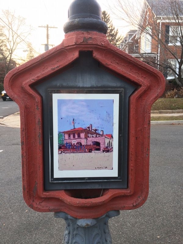
Police Call Boxes such as this one (originally painted blue) were installed in the District after the Civil War. Officers on foot patrol used this secure telegraph system to contact the station, accessing the box with a now highly collectible . . . — — Map (db m129486) HM
The Northumberland
Apartments
Erected 1909 - 1910
Albert H. Beers, Architect
Harry Wardman, Builder
was listed in the District of Columbia
Inventory of Historic Sites and in
the National Register of Historic Places,
U.S. . . . — — Map (db m212704) HM
Fire Fact, June 25, 1925
The era of horse-drawn fire apparatus ends with a ceremonial "final run" with Barney, Gene and Tom pulling a 1905 Steam Pumper belonging to Engine Company 19.
Fire Department information and images courtesy . . . — — Map (db m112631) HM
The first development called “Woodley” named after the Woodley estate (now home to the Maret School), was owned by Mrs. A. E. Kervand and was first recorded as a subdivision in 1875. Winding Woodley Lane was its main street. By 1878 . . . — — Map (db m112394) HM
The name Harry Wardman (1872 - 1938) is practically synonymous with Woodley Park, having built numerous houses and apartments in the neighborhood. Wardman built his own home on the corner of Connecticut Avenue and Woodley Road in 1909. He later . . . — — Map (db m87503) HM
Woodley Park’s most prolific architect, Mihran Mesrobian (1889-1975) started his career as a palace architect in Constantinople during the twilight of the Turkish sultans. The Turkish-born Beaux-Arts trained Armenian worked on the restoration of . . . — — Map (db m87506) HM
Developers first plotted the residential neighborhood of Woodley Park in 1875, attached to this high land overlooking Rock Creek, where Philip Barton Key had built an estate that he named Woodley. (You can see the Woodley mansion on the campus of . . . — — Map (db m87471) HM
Across the street is the former 11th Precinct Police Station. In 1993 it became the Max Robinson Center for Health and Living, providing services for people with HIV/AIDS.
Whether by design or by accident, in 1910 the city built . . . — — Map (db m100763) HM
Across the intersection to your left is Rose's Row, three one-family and three two-family houses built in 1890 by local saloon-keeper William H. Rose. Rose's son Daniel designed them in the popular Italianate style and carefully crafted a . . . — — Map (db m130720) HM
Just beyond this sign is the edge of Barry Farm Dwellings, built during World War II for African American families. The war had caused acute housing shortages, so people divided large homes into rooming houses, took in boarders, or crammed into . . . — — Map (db m113608) HM
The Handsome Italian Renaissance Building. across the street opened as James G. Birney Elementary School in 1901. Its wood-frame predecessor, the original 1889 Birney School, was the first school built with public funds for African American . . . — — Map (db m100669) HM
Since 1936 Friendship House, across the street, has operated an array of social service programs from this grand Federal style house, also known as "The Maples." Friendship House is the city's oldest such agency. It was founded in 1904 by . . . — — Map (db m166999) HM
The Presbytery of the Potomac organized the Capitol Hill Presbyterian Church on April 11, 1864 and installed its organizing pastor, the Reverend John Chester, D.D.
This gothic style building was designed by Washington architect Emil . . . — — Map (db m116128) HM
Carolina Theatre
was located at the southwest corner of Eleventh Street & North Carolina Avenue
Razed early 1970s
Drawing of entrance on North Carolina Avenue based on plans at the National Archives
B.F. Meyers (1865-1940), . . . — — Map (db m128222) HM
When the Southeast-Southwest Freeway above you was constructed along the route of Virginia Avenue in the 1960s, houses and businesses were destroyed and hundreds of residents were relocated.
Fashionable dwellings (included the home of . . . — — Map (db m184999) HM
In the early evening of November 22, 1963, a clutch of people stood forlornly on this bridge spanning Suitland Parkway. They awaited the procession carrying the body of slain President John F. Kennedy from Andrews Air Force Base to Bethesda . . . — — Map (db m130723) HM
The parcel of land on which 99M—a 220,000 square-feet LEED Platinum Class A Office building—is set was once the site of Normandie Liquors. According to JDLand.com, Normandie Liquors "seemed to become a symbol of old versus new" in the neighborhood, . . . — — Map (db m141572) HM
Building 116 was part of the combined boiler and Power Plant that serves the Washington Navy Yard and Annex. The Building is significant as part of the industrial complex, and represents the physical expansion of the yard that followed the . . . — — Map (db m141569) HM
Constructed by EYA in partnership with the DC Housing Authority, these 327 townhomes are part of the rebuild of the Arthur Capper Carrollsburg public housing complex. The earlier 707 housing units were demolished in 2005 and these homes are a blend . . . — — Map (db m141554) HM
The Lumber Storage Shed, constructed in 1918-1919 in the wake of World War I, is one of the last surviving service facilities at the Navy Yard. Originally composed of two open-air concrete structures set parallel to each other, the separate . . . — — Map (db m113791) HM
In 1815 the Washington City Canal, linking the Anacostia River to the Potomac via downtown Washington, was completed. The canal attracted businesses where it met the Anacostia River. Among the first was the eight-story sugar refinery of merchant . . . — — Map (db m113629) HM
The St. Paul African Union Methodist Protestant (AUMP) Church is the first and only church in Washington, DC that evolved from what is considered the oldest incorporated, independent African American denomination in the country. The . . . — — Map (db m113632) HM
Bringing a Landmark Back to Life
St. Elizabeths overs approximately 350 acres. The West Campus, on the other side of the historic wall in front of you, is comprised of 176 acres and is the oldest part of the historic campus. It is . . . — — Map (db m131529) HM
1 Summerhouse
Constructed in 1879-1880 , the Summerhouse offers visitors a shaded place to rest, admire views of the Capitol, and have a drink of water. Olmstead's principal architectural assistant Thomas Wisedell, was the designer. The . . . — — Map (db m111468) HM
General Plan for the Improvement of the U.S. Capitol Grounds
by Frederick Law Olmsted, 1874
Following the extension of the Capitol in the 1850s-1860s, the grounds were enlarged in 1872. In 1874 Congress commissioned Frederick Law Olmsted to . . . — — Map (db m186859) HM
U.S. Botanic Garden
Architecture by Bennett, Parsons & Frost, 1933
Easily recognized by the sparkling glass dome of its Conservatory, the U.S. Botanic Garden, overlooking the National Mall, is located near the U.S. Capitol. Visitors . . . — — Map (db m110445) HM
The Peace Monument
By Franklin Simmons, 1878
The Peace Monument, also called the Naval Monument, was erected to commemorate the naval deaths at sea during the Civil War. At the top of the 44-foot monument, Grief, sometimes called . . . — — Map (db m110449) HM
The United States Botanic Garden (USBG), established by the Congress in 1820 is one of the oldest botanic gardens in North America. It is a living plant museum dedicated to demonstrating the aesthetic, cultural, economic, . . . — — Map (db m110451) HM
For the past six years, the NPS has been making temporary repairs to the bridge while planning a full rehabilitation. In February 2016, the Federal Highway Administration (FHWA) informed the NPS that despite these emergency repairs, without a . . . — — Map (db m140994) HM
Completed in 1932, Arlington Memorial Bridge was built in a neoclassical style and extended Pierre L'Enfant's (1754-1825) original plans for the District of Columbia. The bridge was designed by the prominent architectural firm of McKim, Mead and . . . — — Map (db m150819) HM
East Potomac's Miniature Golf Course
listed in the
National Register
of Historic Places
as part of the East and West Potomac Parks Historic District
by the United States Department of Interior
Visitors enjoy . . . — — Map (db m190285) HM
Created in 1932, Bartholdi Park is named after Frédéric Auguste Bartholdi, the sculptor of the historic Fountain of Light and Water located at its center. Bartholdi is best known for designing the Statue of Liberty.
The beds in . . . — — Map (db m110435) HM
The Fountain of Light and Water was designed by Frédéric Auguste Bartholdi for the 1876 Centennial Exposition in Philadelphia, PA. The namesake of Bartholdi Park is best known for designing the Statue of Liberty (Liberty Enlightening the . . . — — Map (db m110438) HM
The Bartholdi Fountain was created by Frederic Auguste Bartholdi (1834 - 1904), the French sculptor who also designed the Statue of Liberty. It was first exhibited in Philadelphia at the International Exposition of 1876. The fountain was . . . — — Map (db m186822) HM
James Wilson Memorial Arch
So named by the Congress, in Resolution approved by
President Franklin D. Roosevelt, June 16, 1934,
to honor the memory of
James Wilson
1835-1920
Secretary of Agriculture 1897-1913
. . . — — Map (db m110425) HM
Bartholdi Gardens is a living demonstration of sustainable landscaping. Two goals of sustainable landscape design are to limit waste and mimic nature in the built environment.
In the recent renovation of Bartholdi Gardens, much of the . . . — — Map (db m211426) HM
This building was originally constructed in 1881 for use by the Bureau of Engraving and Printing. In an effort to fireproof the building and protect it contents, only stone, brick and metal materials were used in its construction. By 1907 the . . . — — Map (db m114144) HM
Al Jolson, star of the first "talking" movie, The Jazz Singer, grew up as Asa Yoelson at 713 4½ Street (once near this sign). The Yoelsons arrived from Lithuania in 1880. Asa's father Rabbi Moses Yoelson served as cantor and . . . — — Map (db m130905) HM
When urban renewal threatened to destroy three of Washington's oldest structures, dating from the late 1700's, history-minded citizens organized to stop the bulldozers. As a result, when architect Chloethiel Woodard Smith designed the . . . — — Map (db m130917) HM
You are standing in the heart of one of Washington, DC's oldest—and newest—neighborhoods. For 150 years Southwest Washington was a working waterfront community. Then urban renewal changed the landscape forever. Today Southwest is . . . — — Map (db m130903) HM
Emerging from master planner Pierre L'Enfant's District Plan completed in 1791, Southwest D.C. began largely as an industrial shipyard, with fishermen selling directly off their boats until the Municipal Fish Market was established. In the years . . . — — Map (db m213299) HM
All that surrounds this sign resulted from the nation's first urban renewal project. To your left is Arena Stage, a leader in the resident company theater movement. Founded as an innovative theater-in-the-round in an old downtown movie . . . — — Map (db m133833) HM
Directly across Fourth Street from this sign is the Capitol Park complex of high-rise and townhouse residences. Designed by Chloethiel Woodard Smith of Satterlee and Smith, the high-rise (now Potomac Place) opened in 1959 as the first new . . . — — Map (db m130906) HM
More than 50 years after it opened in 1964, Tiber Island stands as a tribute to the idealism that marked the new Southwest. Planners hoped the neighborhood's mid-20th-century modern architecture, mix of high- and low-rise structures, balance . . . — — Map (db m130607) HM
William Syphax Public School, built in 1902 to serve African American children under the city's then-segregated school system, honored the first president of the Board of Trustees of the DC Colored Schools.
The original building was designed . . . — — Map (db m136836) HM
The Washington Monument honors George Washington, hero of the American Revolution and first president of the United States. When this stunning stone obelisk was completed in 1884, it was the tallest building in the world. Today the monument . . . — — Map (db m194688) HM
Built above an underground museum complex, the Haupt Garden is actually a rooftop garden. As such, the limited soil depth and the protection provided by the surrounding museums create a climate milder than is typical of the region. — — Map (db m184554) HM
A popular urban oasis since its completion in 1987, the 4.2-acre Enid A. Haupt Garden comprises three distinct gardens. The design of each reflects the cultural and aesthetic influences celebrated in the Smithsonian Castle and the surrounding . . . — — Map (db m211330) HM
A popular urban oasis since its completion in 1987, the 4.2-acre Enid A. Haupt Garden comprises three distinct gardens. The design of each reflects the cultural and aesthetic influences celebrated in the Smithsonian Castle and the surrounding . . . — — Map (db m211331) HM
A popular urban oasis since its completion in 1987, the 4.2-acre Enid A. Haupt Garden comprises three distinct gardens. The design of each reflects the cultural and aesthetic influences celebrated in the Smithsonian Castle and the surrounding . . . — — Map (db m211337) HM
A popular urban oasis since its completion in 1987, the 4.2-acre Enid A. Haupt Garden comprises three distinct gardens. The design of each reflects the cultural and aesthetic influences celebrated in the Smithsonian Castle and the surrounding . . . — — Map (db m211341) HM
Since the 1970s, Dan Graham has explored notions of space and perception, creating installations and sculptures that critique modernist suburban architecture and encourage audience participation. For Gordon Bunshaft, a site-specific . . . — — Map (db m184559) HM
The Fountain Garden is modeled after the Court of the Lions at the Alhambra, a 14th-century Moorish palace and fortress in Granada, Spain, now included on UNESCO's World Heritage List. (Moor is a general term for North African Muslims . . . — — Map (db m184548) HM
The Moongate Garden was inspired by architectural and symbolic elements found in the Temple of Heaven, a masterpiece of Chinese architecture and landscape built in Beijing during the Ming Dynasty (1368 - 1644). Now included on . . . — — Map (db m184546) HM
The Moongate Garden was inspired by architectural and symbolic elements found in the Temple of Heaven, a masterpiece of Chinese architecture and landscape built in Beijing during the Ming Dynasty (1368 - 1644). Now included on . . . — — Map (db m211338) HM
Parterre—from a French term meaning "on or along the ground"—originated in the 16th-century Renaissance Italy as an ornamental garden style. The style, which defines garden pace by arranging hedges, flowers, grass, water, and gravel to . . . — — Map (db m110781) HM
The pillars of the Renwick Gates were based on this 1849 drawing by James Renwick Jr., the architect of the Smithsonian Castle. They were constructed in the 1980s from the same kind of sandstone that was used to build the Castle. — — Map (db m110725) HM
George Washington shaped many aspects of the nation's capital. He championed placing the capital along the Potomac River then personally selected the site. He chose architect Pierre L'Enfant to design the city. L'Enfant envisioned a capital with . . . — — Map (db m211376) HM
The Washington Monument honors George Washington, hero of the American Revolution and the first president of the United States. When this stunning stone obelisk was completed in 1884, it was the tallest building in the world. Today the monument . . . — — Map (db m211377) HM
On August 23, 2011, a magnitude 5.8 earthquake centered in Virginia sent tremors throughout eastern North America. This seismic activity affected a number of Washington, D.C. landmarks, including the Washington Monument. National Park Service . . . — — Map (db m49459) HM