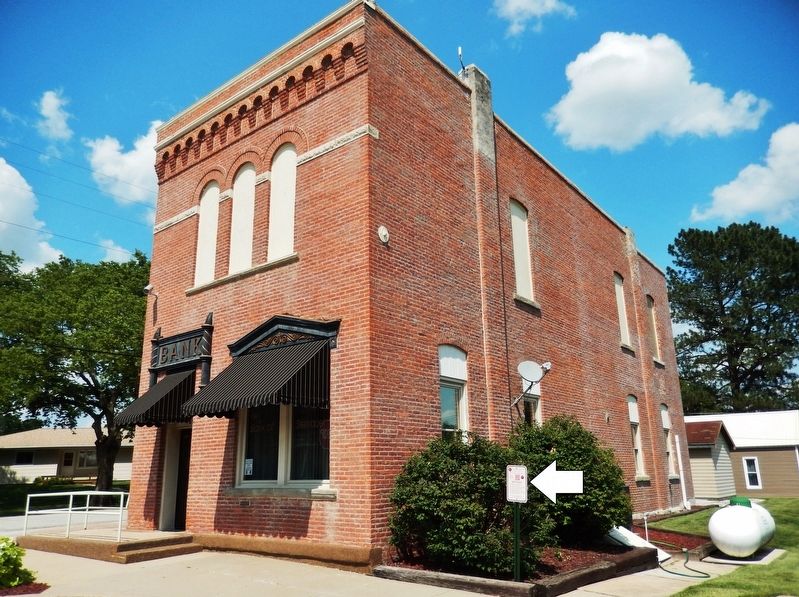
In 1888, the building was constructed by Joseph Steinauer to house his banking business. In 1898, the bank received its charter. The ownership of the bank has remained within the Steinauer family for five generations. — — Map (db m190303) HM
The school and convent were constructed in 1932. They were built to replace ones destroyed by a fire. The new school building featured a beautiful attached convent, which was home to four Benedictine nuns until the school closed in 1970. It was . . . — — Map (db m190308) HM
This structure was built in 1874 by Joseph A. Steinauer, the first Postmaster of the village. It was used as a post office, a bank, and a newspaper office. The bank was moved in 1888 to its current location, and the newspaper was discontinued in . . . — — Map (db m190300) HM
Warnings to avoid “bloody Kansas” prompted the Steinauer brothers, Anton, Nicholas, and Joseph, to settle here in Pawnee County. They arrived in September 1856, only two years after the creation of Nebraska Territory. Famine and depression had . . . — — Map (db m177419) HM
After the Civil War, herds of Texas cattle were driven north to marketing points in eastern Nebraska, but settlement by homesteaders forced the trail farther west each year. Beginning in 1875, Union Pacific selected Ogallala as its main shipping . . . — — Map (db m79377) HM
The first flour mill in Pierce County was constructed here about 1880 by Stephen F. Gilman. Power for its operation came from a dam on the north fork of the Elkhorn River. Flour from the mill was marketed widely under the “Golden Crescent” . . . — — Map (db m206800) HM
Andrew Jackson Higgins, designer and manufacturer of World War II landing craft known as "Higgins boats," was born August 28, 1886, at Columbus, Nebraska. His parents were John Gonegle Higgins, a prominent lawyer and judge, and Annie Long O'Connor . . . — — Map (db m9775) HM
Harold Kramer
Kramer achieved national recognition for his state and national public power leadership as general manager of the Loup River Public Power District. Kramer first became active in Nebraska’s public power systems in 1932 when he . . . — — Map (db m58746) HM
Leo Sokol
Leo Sokol invented and began manufacturing irrigation pumps in 1933 in Duncan. Leo invented the first hydraulic single-cylinder Duncan manure loader. He was a natural inventor who created many other products for the agriculture . . . — — Map (db m58747) HM
Edward Martin Nielsen
Edward Nielsen bought the Columbus Chevrolet franchise in 1926. Soon after, the dealership moved to the 13th Street site where it remained for the next 70 years. Nielsen Chevrolet-Buick was in business one day short of . . . — — Map (db m58748) HM
Vincent Kummer
Born 1821
Berne, Switzerland
John Rickly
Born March 19, 1815
Berne, Switzerland
Jacob Louis
Born September 2, 1834
Wurttemberg, Germany
Charles Reinke
Born May 15, 1828
Germany
Fred . . . — — Map (db m58751) HM
William Gerhold, Sr.
William Gerhold, Sr. formed a partnership with his brother Alfred in 1921 to buy the family business and remained owner and CEO of the Gerhold Company for the next 51 years. Throughout the '20s and '30s, Gerhold was . . . — — Map (db m58752) HM
Edgar Howard
Edgar Howard had a career in the newspaper business that spanned more than 75 years. After a career in various jobs within newspapers, he bought the newspaper in Papillion in 1883 and established a paper in Benkleman four years . . . — — Map (db m58813) HM
Lyman & Robert Mead
Lyman Mead assumed the role of President of Mead Lumber Company in 1927 upon the death of his father, when Mead Lumber was a single yard in Ashland, Nebraska. In 1934, Lyman moved to Columbus and bought the Kaufmann Lumber . . . — — Map (db m58816) HM
The Columbus Powerhouse is one of Nebraska’s largest hydroelectric generating plants and the pulse of the Loup River Public Power District hydroelectric system. The system was financed in 1933 by a $7.3 million New Deal Public Works Administration . . . — — Map (db m182100) HM
The mural reveals important moments in the city’s development by “peeling through” eight of the numerous layers of time from the present to the past.
An aspect of the mural is the transition of color through the piece. It was . . . — — Map (db m58564) HM
During the 1950s and 1960s Paul Zimmerer, working in his auto and farm equipment repair shop in Lindsay, Nebraska, invented a series of irrigation products that changed the landscape of Nebraska agriculture. One was the tractor-towed “Towline” that . . . — — Map (db m181350) HM
This cemetery north of Genoa in Woodville Township is the center of Platte County’s West Hill area. Land for the cemetery was first purchased in 1876 from Will Irwin. The first grave was opened in 1878 for Joshua Middleton, victim of a prairie . . . — — Map (db m181797) HM
In 1873 Horace A. Cowles, Civil War veteran, set up the Cyclone post office in his home one mile east and one mile south of present-day Shelby. A second post office, Arcade, was established one mile east of town in 1879; a year later it moved to . . . — — Map (db m182095) HM
The first publicized report of oil in Nebraska was an 1883 newspaper account of a "vein of petroleum" discovered in Richardson County. Over the next 57 years, the search for oil consumed thousands of dollars, and hundreds of wells were drilled . . . — — Map (db m80107) HM
Humboldt was platted in 1868 and the first business on the city square was established in 1869. Town founder O.J. Tinker deeded two acres for a public square in 1871 and Humboldt was incorporated in 1873. The bandstand in the center of the City . . . — — Map (db m177300) HM
Bellevue, gateway to the upper Missouri and the fur
trade empire, is the oldest continuous settlement in
Nebraska. This town was born, became important, almost
died, and now in the 20th century, has been revitalized.
Fur traders dealing with the . . . — — Map (db m228872) HM
This building of handmade bricks was constructed in 1856 to serve as the Fontenelle Bank. During the financial Panic of 1857 the Fontenelle Bank failed as did most of the other poorly backed wildcat banks in the Nebraska Territory.
In 1861 by . . . — — Map (db m80853) HM
The Armour and Company Icehouse was built in 1897-98 northwest of Memphis, Nebraska. It
was one of the largest icehouses in the country, measuring approximately 180 feet wide, 700 feet
long, and 52 feet high. A 300-horsepower steam engine and two . . . — — Map (db m80432) HM
Most history books focus on the westbound travel along
the trails, but what about eastward movement? The first European-Americans to record seeing the bluffs
were eastbound fur traders returning from the west coast.
After that, fur traders . . . — — Map (db m174344) HM
It was a treeless expanse. Floods and lightning caused grass fires killed seedlings that tried to grow on the prairie around the bluffs, perfect grazing for the bison and elk that lived here. Only on top of the bluffs were trees able to grow. To . . . — — Map (db m164136) HM
Pierre Didier Papin
P. D. Papin was a trusted and valued employee of the American Fur Company and its successors for over thirty years. He was born March 7, 1798, In St. Louis. The Papins were a prominent French merchant family in that . . . — — Map (db m133906) HM
In 1849 Joseph Rogidoux III of St. Joseph, Missouri, licensed in the Indian trade, ordered removal of his outfit from the vicinity of Fort Laramie to this strategic pass over Scotts Bluff, where there was ample wood and water. Evidence from several . . . — — Map (db m99134) HM
There is no enduring memory of the history that happened here. There was no one left behind to remember it.
From faded pages of tattered diaries or survivors several generations removed, we assign the early dwellers here to their proper place in . . . — — Map (db m99184) HM
The river is life. Animals made their paths along it and leading to and from it. Humans followed next; the first traveled lightly, leaving little trace of their passing. Occasionally they would climb the tall bluffs where the height allowed . . . — — Map (db m164108) HM
This millstone is believed to be from the gristmill built by William Smith in 1871 on the Big Blue River south of Beaver Crossing. W. J. Thompson took over the mill in 1873, and it continued to operate until about 1917.
Gristmills were an . . . — — Map (db m76747) HM
For a few years, the Antioch vicinity was one of the most important potash-producing regions in the nation. Antioch grew from a small village to a town of about 2,000. When the First World War broke out, the United States was cut off from European . . . — — Map (db m178812) HM
In 1885 surveyors designated a route through the Sand Hills for a Burlington Railroad branch line. The rails reached this point on the Blaine Thomas county line in 1887, and a town was laid out. It was named Halsey after Halsey E. Yates, the son of . . . — — Map (db m178925) HM
You are near the center of one of the world’s greatest cattle producing areas — some 13 million acres of deep sands with a high water-table exposed in numerous lakes. This great sea of sand was deposited by winds of a desert climate that ended . . . — — Map (db m180889) HM
On August 3 Lewis and Clark held a council with the Oto and Missouria Indians at a site they named "Council Bluff," near present Fort Calhoun, Nebraska. It was the first of many councils they would hold on their journey to the Pacific Ocean. . . . — — Map (db m7794) HM
About 3 a.m. on December 5, 1932, Fort Calhoun marshal Albert Suverkrubbe was shot while trying to apprehend two men fleeing Kruse's Red and White Grocery at 106 S. Fourteenth Street. Suverkrubbe died from his wounds nine days later, leaving his . . . — — Map (db m7767) HM
Between 1855 and 1867 companies like Russell, Majors, and Waddell shipped millions of pounds of freight across the plains to supply military posts and mining camps to the West. After 1861 freighters followed the "Nebraska City-Fort Kearney . . . — — Map (db m223482) HM
Before the transcontinental railroad was completed, the nation entrusted the West's trade and economic survival to an assortment of muleskinners, bullwhackers and stage drivers. From the early 1850s to 1869, the Overland Trail saw lumbering . . . — — Map (db m79840) HM
Massive freighting of supplies by ox and mule trains was a direct result of the establishment of Fort Kearny and other western military posts. The Mormon War and the discovery of gold in the territories of Colorado and Montana increased this . . . — — Map (db m228358) HM
Massive freighting of supplies by ox and mule trains was a direct result of the establishment of Fort Kearny and other western military posts. The Mormon War and the discovery of gold in the territories of Colorado and Montana increased this . . . — — Map (db m79830) HM
141 entries matched your criteria. Entries 101 through 141 are listed above. ⊲ Previous 100