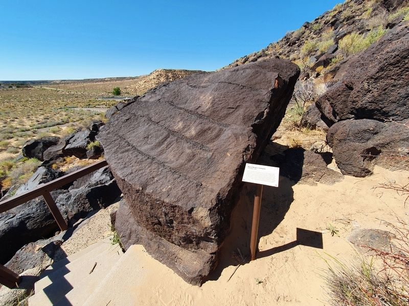
Boca Negra Canyon
Cliff Base Trail
Notice the unusual and varied texture of this basalt boulder.
Basalt is generally considered to be the most common extrusive igneous rock on Earth, composed mostly of calcium-rich
plagioclase and . . . — — Map (db m182866) HM
Five thousand feet below and about 20 degrees
warmer is the city of Albuquerque. It is situated in the
Rio Grande basin within the Rio Grande Rift, a zone of faults
that has formed basins and ranges from southern Colorado
into Mexico. This . . . — — Map (db m180877) HM
This site is named for Victor H. Waldrop and stewardship for is shared by the New Mexico Department of Transportation and local bird enthusiasts. Wind blown-sand deposited at the base of Mescalero Ridge forms a 60 mile expanse of open dunes and . . . — — Map (db m73458) HM
This community was founded in 1894 on the site of
an earlier homestead and stage coach stop. Irrigation
from Bluewater Lake and its proximity on the railroad
and Route 66 allowed development of extensive
agricultural fields, which earned . . . — — Map (db m236574) HM
Created December 31, 1987-Dedicated August 24, 1991. The El Malpais National Conservation Area (NCA) was the first area so designated by Congress in New Mexico. Congress established the NCA to conserve and protect the . . . — — Map (db m100422) HM
Located just north of the great lava bed known as the malpais, Grants began as a coaling station for the Santa Fe Railroad. Around 1880 it was known as Grant's Camp, after the Canadian bridge contractor Angus A. Grant. In 1950, the area's vast . . . — — Map (db m36472) HM
The Bandera Volcano rose up in volcanic fury some 10,000 years ago. The crater is approx. 1400 feet across and 800 feet deep. Bandera is one of the finest examples of an erupted volcano in the country, and one of the most accessible. An ancient lava . . . — — Map (db m164176) HM
Before the days of interstates and automobiles, a journey from Albuquerque to Zuni (about 150 miles) typically took 9 or 10 days. Imagine the relief travelers must have felt when they reached this shady little oasis after walking or riding a horse . . . — — Map (db m163216) HM
Marker Front: The Rio Grande (big river) has been an integral part of the history of New Mexico for thousands of years. Running through the entire state, it is both its backbone and lifeblood. It originates in the southern Rocky Mountains of . . . — — Map (db m67023) HM
“It is my boiled-down, concentrated, solidified and undiluted opinion that the oil development in this Valley so far is only a preliminary skirmish compared with the artillery that will soon follow.” – Martin Yates, Jr., 1924
The brochures . . . — — Map (db m235362) HM
The Illinois State #3 was the first commercial oil well drilled in Southeast New Mexico and the first on state-owned lands in New Mexico.
The oil sand, or "pay," was drilled into on April 9, 1924. At some time in late April or May, the well . . . — — Map (db m235360) HM
Van was a worker's worker and this sculpture is dedicated to all the oilfield workers who make this industry great.
Van Stratton Welch was born in 1880 in a log cabin in Allegheny County, New York, the son of a Civil War veteran and oil barge . . . — — Map (db m235359) HM
These vast and magnificent caverns contain over 21 miles of explored corridors. The chambers contain countless stalactites and stalagmites unrivaled in size and beauty. The caverns are within a reef that formed in an ancient sea 240 million years . . . — — Map (db m61473) HM
Fellow Travelers, imagine the land and mountains before you covered by a deep inland sea. Then imagine a large reef forming over 255 million years ago. As the inland sea vanished minerals such as calcite and aragonite bonded together the sea life . . . — — Map (db m61488) HM
Most famous of the many historic landmarks in the Black Range country is the Kneeling Nun. So named for its resemblance to a nun kneeling in prayer before a great altar. Many legends have grown up around the giant monolith which rests near the . . . — — Map (db m38228) HM
Wind and water gradually sculpted the volcanic tuff at City of Rock creating the rows of monolithic blocks that gave this park its name. Camping/picnicking sites are tucked away among these Stonehenge-like formations and the park also features a . . . — — Map (db m64725) HM
Grassy plains meet pine dotted uplands in this transition from Great Plains to Basin and Range provinces. Plains to the east are capped by caliche, sand, and gravel which are deeply eroded into the underlying bedrock in places. To the west, faulting . . . — — Map (db m91047) HM
Flowing out of the Rockies, the Canadian River has cut a gorge 600 feet deep through sedimentary strata of the High Plains. Rim elevation is 5,400 feet. — — Map (db m62852) HM
Marker Front: Wide alluvial plains of Southwest New Mexico are feature of basin and range province with isolated fault block mountains scattered like islands from a sandy sea. Volcanic rocks form most of Cedar Mountains to south and Pyramid . . . — — Map (db m42271) HM
Following earlier oil discoveries in the Lea
County area, Ronald K. DeFord, of Midwest
Refining Co., now Amoco, came to Hobbs
to survey for a new drilling site. Drilling began
October 12, 1927, oil was discovered at
4,065 feet, and the new well . . . — — Map (db m235222) HM
Spanish explorers called this extensive lava flow malpais, or badlands. The river of lava that flowed down this "Valley of Fires" erupted from a volcano some 7 miles north of here about 1000 years ago. Extending through the valley for 44 miles, the . . . — — Map (db m45911) HM
Fort Stanton Cave
Has been designated a
Registered
Natural Landmark
The site possesses exceptional value as an illustration of the nation's natural heritage and contributes to a better understanding of man's environment . . . — — Map (db m108359)
Great cliffs of red sandstone form the southern boundary of the San Juan basin. The strata that are exposed here are the gently upturned edge of the structural basin which contains coal, uranium, oil and gas resources. The Zuni mountains to the . . . — — Map (db m124576) HM
The landscape before you has changed little over time. It remains remote and quiet, with little visible evidence of human influence. The Sangre de Cristo Mountains in front of you formed as ancient sedimentary rocks were faulted upward. Lying in . . . — — Map (db m156799) HM
Sediments shed from the rising mountains to the west formed the Llano Estacado, later to be bypassed by streams such as the Pecos and Canadian Rivers and left standing in bold relief with a relatively level, uneroded caprock surface. Croplands on . . . — — Map (db m91040) HM
The colorful formations exposed here are the slope forming Chinle Shale of Triassic age, deposited in streams, lakes, and floodplains some 250 million years ago and the cliff-forming Entrada Sandstone of Jurassic age deposited as windblown sand some . . . — — Map (db m73158) HM
Colorful red rocks of Entrada Sandstone are domed up by deep seated igneous intrusions to be exposed by erosion. The same igneous activity created the Carrizo Mountains to the west. Uranium deposits in the Morrison Formation just above the Entrada . . . — — Map (db m36455) HM
Prominent landform of north-eastern New Mexico that extends for almost 100 miles
between Las Vegas and Clayton. From this point, the grass-lands
of the High Plains reach northwestward to the foot of the Southern Rocky Mountains which rise to . . . — — Map (db m144177) HM
About one million years ago, the magnificent valley before you was formed by collapse, after a series of tremendous volcanic eruptions ejected a volume of material more than 500 times greater than the May 1980 eruptions of Mt. St. Helens. This event . . . — — Map (db m119763) HM
The name Tesuque is a Spanish variation of the Tewa name Tetsugeh, meaninig "narrow place of cotton wood trees." The small Tewa speaking pueblo of Tesuque was established before 1200, and was first visited by Europeans in 1591. It is one of the most . . . — — Map (db m32852) HM
Galisteo Basin The extensive lowland south of here is called Galisteo basin, a sag in the earth’s crust where rock layers are depressed and thickened. It is one of the northernmost basins in the Basin and Range province in New Mexico and is . . . — — Map (db m160695) HM
To the east beyond Caballo Reservoir are the rugged Caballo Mountains, uplifted about 3 miles above the downdropped Río Grande trough, along the fault scarp at the edge of the mountains. Lowest slopes are ancient granites. Black ironstone beds are . . . — — Map (db m45107) HM
Fort Craig is on alluvial gravelly sands, derived from the mountains to the west, sloping toward Rio Grande to east. Magdalena Mountains to northwest and San Mateo Mountains to west are mainly thick piles of volcanic rocks. San Andres Mountains on . . . — — Map (db m68055) HM
Magdalena Mountains to the west are topped by South Baldy at 10,783 feet; Magdalena Peak at 8,152 feet. La Jencia plain to the east is bisected by Water Canyon three miles below this marker. The bench along the edge of the mountains is Magdalena . . . — — Map (db m38471) HM
The mountain range seen along the east bank of the Rio Grande is named after Father Cristobal de Salazar of the 1598 Juan de Onate expedition. The northern edge of the twenty-one mile range is said to resemble the profile of the good friar. This . . . — — Map (db m68056) HM
Winds blowing across the usually dry, sandy riverbed of Rio Salado formed dunes along this part of the Rio Grande Valley. The Rio Grande, just southwest here, follows a massive geological trench shaped millions of years ago when huge blocks of land . . . — — Map (db m67211) HM
Cinder cones experience a single eruptive period, and then die. Several explosive eruptions created Capulin Volcano, during a period as short as one year or as long as nine or more years. Today Capulin Volcano is extinct.
Volcanic ash, . . . — — Map (db m89235) HM
An outstanding example of an extinct volcanic cinder cone, Capulin Volcano was formed as early as 10,000 years ago. In cinder cones, lava pours from cracks in the base rather than over the top. Capulin itself was the escape hatch for gases that blew . . . — — Map (db m88756) HM
An outstanding example of an extinct volcanic cinder cone, Capulin Volcano was formed as early as 10,000 years ago. In cinder cones, lava pours from cracks in the base rather than over the top. Capulin itself was the escape hatch for gases that blew . . . — — Map (db m88759) HM
The shortgrass prairie and mountain forest meet here in the high plains of northeastern New Mexico. This transition between two ecosystems provides habitat for many different plants and animals. The shortgrass prairie is the western limit of the . . . — — Map (db m89230) HM
The late 1800s were a time of homesteading and private acquisition of public lands. Conservationists began working to preserve some public lands like Yellowstone and Yosemite. In 1891, the General Land Office of the Department of the Interior . . . — — Map (db m89224) HM
This region of volcanic activity is the Raton-Clayton Volcanic Field. It has been active periodically, beginning at the western edge of the field with the Raton Phase from 9 to 3 million years ago. The Capulin Phase began about 1 million years ago . . . — — Map (db m89228) HM
Capulin Volcano directly in front of you is a dramatic example of the volcanic processes that shaped northeastern New Mexico. Capulin Volcano National Monument preserves this classic cinder cone. About 60,000 years ago thunderous explosions sent . . . — — Map (db m89223) HM
Largest extinct volcano in northeastern New Mexico, Sierra Grande rises to an elevation of 8,720 feet, one of many volcanos, cinder cones, and flows that cover more than 1,000 square miles of area in northeastern New Mexico and southeastern . . . — — Map (db m88754) HM
Largest extinct volcano in northeastern New Mexico, Sierra Grande rises to an elevation of 8,720 feet, one of many volcanos, cinder cones, and flows that cover more than 1,000 square miles of area in northeastern New Mexico and southeastern Colorado . . . — — Map (db m88761) HM