On Local Route L2011, 1 kilometer south of Munster Route R585, on the left when traveling south.
Welcome to the Ambush Site at Beal na Blath, where General Michael Collins, "Commander-in-Chief" of The Irish Army, was assassinated on 22nd August 1922.
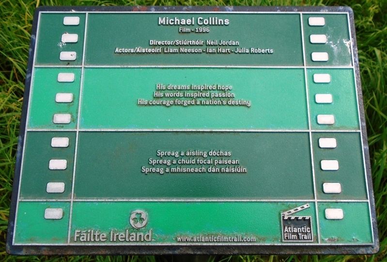
Michael Collins and his party left Cork City at approximately 6am that morning, on . . . — — Map (db m139617) HM
English:
Cove Fort was built by Vice-Admiral Malcolm, the first Naval Commander of the Navy garrison in Cobh, in the mid 18th Century as a fortification for the garrison. The Fort comprised of a barracks, with 3 tiers of twenty four . . . — — Map (db m85827) HM
This area has been a place of worship and burial from Celtic times to the present day. The great diversity of history and culture of Cobh is reflected on the many headstones and epitaphs of those interred here among them, Jack Doyle, Dr. James Roche . . . — — Map (db m85823)
The Cunard Liner, torpedoed and sunk by U Boat U20 off the Cork Coast on 7th May, 1915,
With the loss of 1198 lives.
Many survivors and dead were brought ashore here.
170 of the victims were buried in the nearby
Clonmel (Old Church) Cemetery. . . . — — Map (db m85818) HM WM
On Beechmount, 0.1 kilometers east of Thomas Kent Street, on the right when traveling east.
Táimid réidh anois, a cheannasaí!
Nauair a shroich an Ceannasaí Seosaimh K. Taussig, Cabhlach na Stáit Aointaithe Meiriceá, Cóbh ar 4ú Bealtaine 1917, bhí scuadrún longa cogaidh SAM ina dteannta chun teacht i . . . — — Map (db m163613) HM
On Munster Route R603, on the right when traveling north.
Kilbrittain Castle is the oldest inhabited castle in Ireland. The Castle is said to date from 1035 where the original fortress was thought to have been built by Mahon, grandson of Brian Boru. It has been occupied by Irish chieftains, . . . — — Map (db m139602) HM
On Munster Route R603, on the right when traveling north.
THE BOOK OF LISMORE. It is believed that the Book of Lismore was compiled in the 15th Century to commemorate the marriage of the Gaelic lord Finghin Mac Cárthaigh Riabhach, of Kilbrittain Castle, to Caitilín, daughter of the seventh . . . — — Map (db m139606) HM
Annie Moore and her brothers Anthony and Philip embarked from this town on 20 December, 1891 on the S.S. Nevada. Annie was the first person to be admitted to the United States of America through the new immigration centre at Ellis Island, New York . . . — — Map (db m85821) HM
On Cork Street at Chairmans Lane, on the left when traveling north on Cork Street.
Thóg Maurice Bacach Fitzgerald, larla Dheasmhumhan Caisleán Deasmhumhan c. 1500. Sampla maith de theach túir uirbeach, is éard atá sa chaisleán ná daingean le tithe stórais ar cúl agus oifigí tí ar an gcéad agus ar an dara hurlár. Tógadh . . . — — Map (db m137073) HM
On Friar Street just west of Cork Street, on the right when traveling west.
Sna 1830'aidí, ag deireadh ré na bPéindlíthe, tógadh Séipéal Eoin Baiste, in áit foirgneamh díon tuí a bhí níos lú. Dhear an Bráthair Michael Augustine O'Riordan an stíl clasaiceach atá air agus dhear sé roinnt séipéal eile i gCorcaigh . . . — — Map (db m137067) HM
On Market Lane, on the right when traveling north.
Múseum (Teach na Cúirte)
Teach na Cúirte atá anois air ach be é Teach an Mhargaidh é ar dtús, croilár tráchtála an bhaile áit a mbítí ag trádáil sna háirsí ar urlár na talún. Tógadh é thart ar 1600. Dúnadh roinnt de na háirsí i 1706, . . . — — Map (db m137111) HM
On Pearse Street (Munster Route R605) at Market Lane/The Glen, on the right when traveling north on Pearse Street.
We recently completed the restoration of the Old Kinsale Fish [M]arket wall adjoining the Blue Have[n] Hotel which now forms the entrance to the Blue Haven Bar and surrounding areas. The Blue Haven Hotel is built on the site of the Old Fish . . . — — Map (db m137173) HM
On Pier Road (Munster Route R600) 0.3 kilometers south of Emmet Place, on the left when traveling south.
I 1588 shocraigh Philip III, i ndiaidh theip Armáid na Spáinne agus scrios phéire eile i stoirmeacha i mblianta deiridh Philip II, go dtabharfadh sé tacaíocht dhíreach do lucht éirí amach na hÉireann a bhí ag troid Shasana le súil agus go . . . — — Map (db m137476) HM
On Cork Street (Munster Route R600) at Market Lane, on the left when traveling south on Cork Street.
Tógadh Rinn Chorráin déanach sa 17ú céad ar shuíomh dhaingniú chósta níos luaithe. Is sampla claisiceach é de dhún réaltógach. Tá Rinn Chorráin ar cheann de na dúin mhíleata is mó sa tír agus tá ceangal aige le cuid de na heachtraí is . . . — — Map (db m137242) HM
On Pier Road (Munster Route R600) just south of Emmet Place, on the right when traveling north.
Tar éis Chath Chionn tSáile thosaigh obair thógála ar An Seandaingean i 1602 faoi stiúrthóireacht an Innealtóra Paul Ive. Críochnaíodh é i 1604 ar chostas £645. Is dún mór, urdhúnta, peinteagánach, é An Seandaingean agus é taobh istigh de . . . — — Map (db m137244) HM
On Church Square just west of Cork Street, on the right when traveling west.
Timpeall 1200 thóg na Normannaigh Teampall Mheilteog ar shuíomh an aireagail 6ú aoise agus níl mórán athrú déanta air, agus é ina ionad adhartha ag Críostaithe sa mbaile ó shin. Tá túr suntasach ann agus roinnt fuinneoga daite agus . . . — — Map (db m137360) HM
On Pier Road (Munster Route R600) at Emmet Place, on the right when traveling south on Pier Road.
The restored Fish Shed (using recycled material) is a living link with Kinsale's thriving fishing industry of old. Hundreds of Kinsale hookers, small inshore craft with 3 man crew, were joined by fleets from other parts of Ireland, the Isle of . . . — — Map (db m137269) HM
On Market Square at Guardwell, on the right when traveling east on Market Square.
Kinsale is a sea-port, parliamentary borough, and market town, in the parishes of Saint Multose and Ringcurran barony of Kinsale, County of Cork, 172 miles s.w. from Dublin, 12½ s. and 11 e.s.e. from Bandon; eligibly situated near the . . . — — Map (db m137282) HM
On Market Lane at Milk Market, on the right when traveling west on Market Lane.
there were four walled towns in county cork: cork city, youghal, bandon and kinsale. as with walled towns all over europe in the middle ages, the purpose was to provide security against attack and to create a commercial and political entity. in . . . — — Map (db m137145) HM
On Market Street at Milk Market, on the right when traveling west on Market Street.
History: Kinsale Town Wall
In the year 1381, King Richard II of England declared that the town of Kinsale being situated on the sea shore and of late having recieved [sic] insult and attack from Spanish and Irish enemies and . . . — — Map (db m137118) HM
On The Glen (Munster Route R605) just north of Market Lane/Pearse Street, on the left when traveling north.
Restaurant D'Antibes dedicated to the
formal twinning between
Kinsale-Cionn TSáile and Antibes-Juan Les Pins
Signed by Cllr. Michael Frawley
Chairman of Kinsale U.D.C.
and M. Pierre Merli, Mayor of Antibes-Juan Les Pins
on 28th of . . . — — Map (db m137170) HM
On Pier Road (Munster Route R600) 0.3 kilometers south of Emmet Place, on the left when traveling south.
In memory of
all lost seafarers
from the port of Kinsale
Kinsale Hooker
19th c. Fishing vessel
His hooker's in the Scilly Van
when seines are in the foam
but money never made the man
nor wealth a happy home.
So, blessed . . . — — Map (db m137497) HM
The Kinsale Tidy Towns project for 2018 was for the erection of this sign which details a number of nautical items which are stored here at the back of the Museum (see photos No's 1,2 & 3). It entailed some restoration work on some of the items, . . . — — Map (db m137116) HM
On Market Lane, on the right when traveling north.
Peter Barry arrived in Kinsale in 1963 and settled in Scilly where he made his home. In those early years he operated and developed Scilly's unique Spaniard Pub and the Man Friday restaurant, and later the Grey Hound Bar in Market Place.
Peter . . . — — Map (db m137075) HM
On Market Lane at Milk Market, on the right when traveling west on Market Lane.
Up to this time, William Smith & Sons had relied almost entirely on the increasing trade in sweepers, scrapers, spare parts and brushes. The range of machines available had been frequently updated and fifteen types of sweepers were now being . . . — — Map (db m137148) HM
On Church Square just west of Cork Street, on the right when traveling west.
In the days when Kinsale was a great maritime centre it was an important port of call for fresh water. It was known in Irish as Fan na dTubraid, the Slope of the Springs/Wells and there were many public and private wells in the town. Some were the . . . — — Map (db m137271) HM
On Market Square at Guardwell, on the right when traveling east on Market Square.
The Town Pound was an essential part of the administration of the old town, located near the Market House, the Potato Market and the Broadstone. It had replaced the Old Pound at the top of Barrack Street and was for the care of stray livestock, . . . — — Map (db m137294) HM
On Pearse Street (Munster Route R605) at Market Lane/The Glen, on the left when traveling north on Pearse Street.
This plaque
commemorates the official opening
of the refurbished premises by
The Honourable Patrick J. Kennedy,
Member of Congress,
Rhode Island, USA.
14th. April, 1998. — — Map (db m137169) HM
On West Square just south of Castle Street (National Route N22), on the left when traveling south.
Commemorating
the visit of
President
Mary Robinson
February 24th
1996
——————————
Commissioned
and
Unveiled
by
Dermot Desmond
First recipient of
The . . . — — Map (db m139626) HM
On West Square just north of South Square, on the left when traveling north.
Bealick Mill
This recently restored corn mill, located a short distance outside Macroom on the Coachford road, marks the site of an area and a building of deep historical significance. In 978 Brian Boru defeated the Danes, for . . . — — Map (db m139654) HM
History.
The first Castle is thought to have been built here in the reign of King John between 1200 and 1250. Macroom Castle was the home of McCarthys, Lord of Muskerry, after the McCarthys displace[d] the O'Flynns, previous Lords . . . — — Map (db m139648) HM
On Old Head Ring Route, on the right when traveling south.
Lusitania Memorial Garden
officially opened by
Minister Simon Coveney T.D.
in the presence of
Cllr. Séamus McGrath
Mayor of County Cork.
7th May . . . — — Map (db m139595) HM
On Old Head Ring Route, on the right when traveling south.
On the 12th of February 1874, the 500 ton German barque HERCULES von BARTH, was en route from Barrow-in-Furness to Cardiff to collect a cargo of coal. As the result of a storm the ship was driven westward in a strong gale. It eventually . . . — — Map (db m139529) HM
On Old Head Ring Route, on the right when traveling south.
Arrivals and farewells
Old Head, legendary seat of the kings of the southern half of Ireland, marks the start or end of many journeys.
[Background map caption reads]
The siege and battle of Kinsale, 1601 from the . . . — — Map (db m139528) HM
On Old Head Ring Route, on the right when traveling south.
In memory of those who
sailed on the R. M. S. Lusitania
on 7th May 1915.
This perforated image has 34,513 holes
in 7 different sizes.
Manufactured by Graepel Perforators
and Weavers Ltd., Kinsale. Donated to
the . . . — — Map (db m139527) HM
On Old Head Ring Route, on the right when traveling south.
A VERY SPECIAL AND PERSONAL REQUEST
August 2017
Kilkeel, Newry, Co Down
Dear Mr Hannaway,
I am writing this letter to you personally, in the hope that the matter in question can be dealt with promptly and a satisfactory . . . — — Map (db m139562) HM
On Old Head Ring Route, on the right when traveling south.
A handcast concrete pillar
tapering to a flat top
Part of a network of
surveying stations used by
Ordinance [sic - Ordnance] Survey Ireland
for mapping
Erected 1959 — — Map (db m139559) HM
On Old Head Ring Route, on the right when traveling south.
In memory of the 1198 civilian lives
lost on the Lusitania 7th May 1915
off The Old Head of Kinsale
—————————
This memorial
was unveiled by
Hugh Coveney T.D.
Minister for . . . — — Map (db m137568) HM