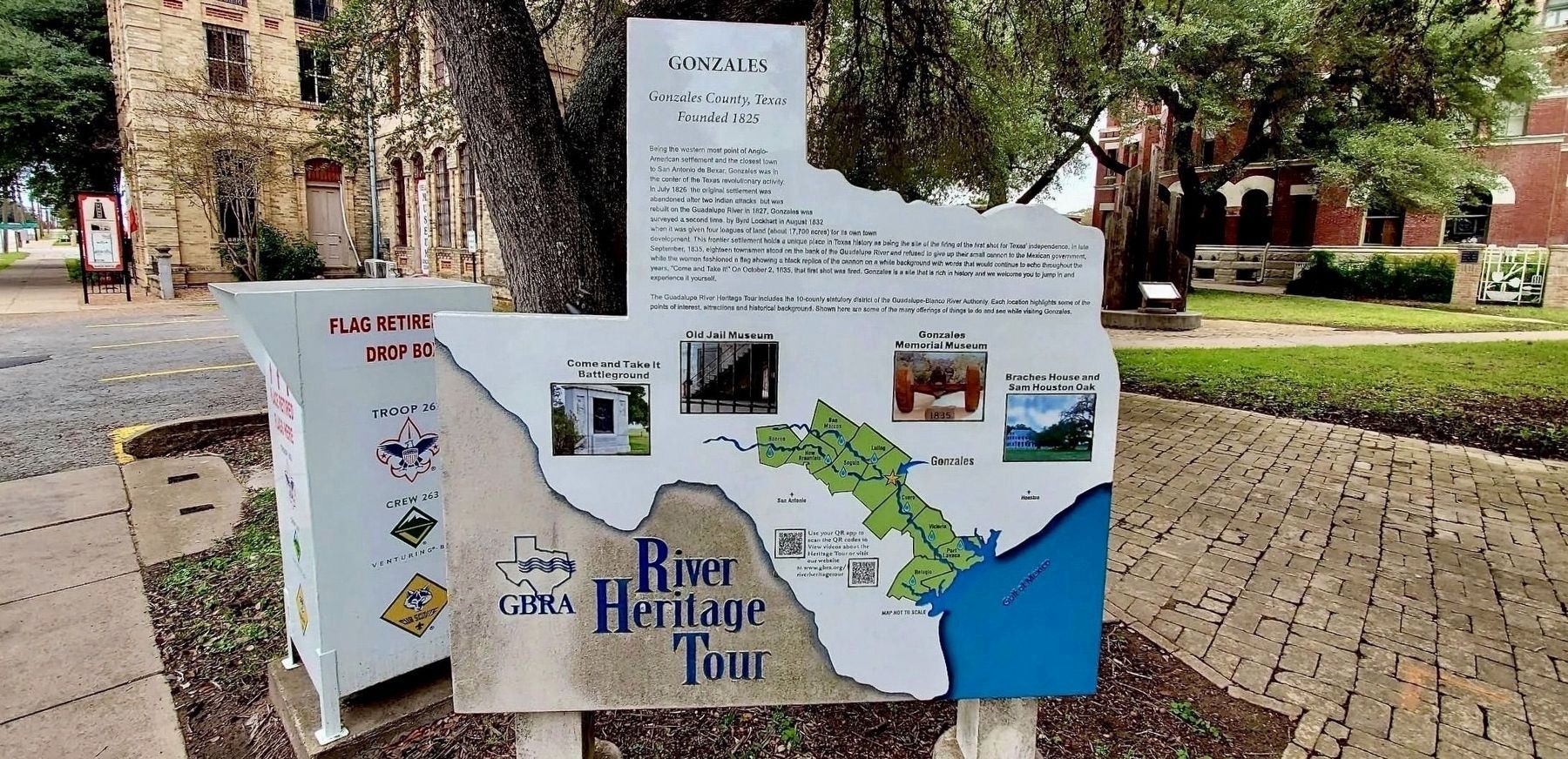
Being the western most point of Anglo-American settlement and the closest town to San Antonio de Bexar, Gonzales was the center of the Texas revolutionary activity. In July 1826 the original settlement was abandoned after two Indian attacks but was . . . — — Map (db m290095) HM
Born in Eagle Lake and known as the last of the Black Hat Rangers, Zeno Smith (1902-1972) worked as a cowboy and rancher, and in his family's meat market. In 1935, he became a Texas Ranger, following in the footsteps of his grandfather and older . . . — — Map (db m201977) HM
Brite Cemetery has served citizens of Atascosa County since the 1850s. It was formally set aside when Thomas Ransdele Brite passed away in 1859, though the earliest marked burial is that of his infant son, Dan (d. 1854). Thomas Brite was born in . . . — — Map (db m56588) HM
John Wesley Hardin was one of the most notorious outlaws of the old west and Charlie Webb was a Brown County sheriff's deputy who was shot and killed by Hardin. Charlie Webb was a Texas Ranger and served Brown and San Saba Counties. In 1874 Webb had . . . — — Map (db m248265) HM
Only eighteen men remained in Gonzales September 25, 1835 when Colonel Domingo de Ugartechea sent 4 soldiers to return the "Gonzales" Cannon to San Antonio de Bexar. Andrew Ponton, Alcalde (mayor) of Gonzales, politely stalled for time, and by . . . — — Map (db m280763) HM
All Slaves Are Free!
Galveston Texas: Ashton Villa June 19, 1865
Two and a half years after President Abraham Lincoln's historic Emancipation Proclamation, U. S. Major General Gordon Granger took command of the District of Texas . . . — — Map (db m187621) HM
In 1875 and 1876, when the Galveston Harrisburg & San Antonio Railroad built through Gonzales County, this town was laid out to serve as a shipping point for the surrounding agricultural and ranching area. Hopkinsville, a thriving community five . . . — — Map (db m6978) HM
R. R. "Railroad" Smith (1880-1944) was born in Gonzales County to Alexander Frohock and Mary McGill (Mathews) Smith. Around 1907, Smith moved to Atascosa County where he opened up a law practice and entered into the newspaper business with a cousin. . . . — — Map (db m56668) HM
Tennessee native Abraham Roberts wed Cynthia Jeffrey in Alabama in 1828. The couple arrived in Seguin, Texas, ten years later with their family. In 1840, Roberts purchased land on Tinney's Creek in what was then Gonzales County. He and other area . . . — — Map (db m180707) HM
Born in Lumpkin County, Georgia, in 1830, William B. Fleming came to Texas before 1850 where he enlisted in Company C of the Texas Rangers Mounted Volunteers and later the Confederate Army during the Civil War. After the war, Fleming moved to . . . — — Map (db m128145) HM
"Fort Waul is the only known earthen embankment fort of its type built and authorized by the Confederate States of America west of the Mississippi River." (Fort Waul: Dorcas Huff Baumgartner, Gonzales Co. Historian)
The Fort Waul historic . . . — — Map (db m293165) HM
A native of South Carolina. Thomas Neville Waul (1837-1903) practiced law in Mississippi before moving to Texas in 1850. After serving in the Provisional Confederate Congress and signing the 1861 Confederate Constitution, he organized Waul's Texas . . . — — Map (db m264160) HM
Born in Georgia, Isham Jones Good (1813-1866) came to Texas in 1835 with a group of volunteers to join the Texian forces in their war for independence from Mexico. As a member of the Georgia battalion, Good went to the aid of Col. James W. Fannin, . . . — — Map (db m149162) HM
Originally known as Prairie Point, a town was platted at this site in 1856 by A.C. Hereford. A native of Virginia, Hereford was a veteran of the Mexican War who had arrived in this area in the early 1850s.
Located on part of the original James . . . — — Map (db m206223) HM
Texas Ranger, T.C. Robinson once described him, “He kills men just to see them kick. He can take two six shooters and turn them like wheels in his hands and fire a shot from each at every revolution.” Others have described Fannin . . . — — Map (db m128660) HM
The opening shots of the Revolution have never been far from Texans' minds. In 1903, a monument was erected near the site of the actual first shot. This monument still stands just down this side road.
In 1935, the State of Texas commissioned . . . — — Map (db m280760) HM
John Bell Hood's Texas Brigade
Texas Infantry Regiments 1st, 4th and 5th, totaling 4,500 men were the only Texas Troops to fight under General Robert E. Lee in the Army of Northern Virginia.
Hardeman's Rifles
4th Texas Infantry, Co. . . . — — Map (db m293166) HM
July 21, 1909 the cornerstone of the Gonzales Confederate Monument was completed and dedicated. Inside the cornerstone was placed a tin box that included a copy of a Special Edition of the Gonzales Inquirer newspaper, rosters of the Confederate . . . — — Map (db m293163) HM
Found in the 1850s during Texas' early statehood, this burial ground served the Ebenezer community and southern Gonzales County. Ebenezer Church, built by Baptists and later serving a Methodist congregation, was located near the cemetery entrance . . . — — Map (db m293191) HM
A native of Gonzales County, Dr. George Holmes (1881-1948) began practicing medicine in Gonzales in 1915. His dream of a fully equipped hospital for the county seat was realized with the completion of this hospital building in 1921. Constructed by . . . — — Map (db m293153) HM
In 1901, plans were made to extend the route of the Galveston, Harrisburg and San Antonio (GH&SA) Railroad to connect the South Texas towns of Cuero and Stockdale. After the 1904 death of rancher John T. Nixon, his widow, Lucinda, and their . . . — — Map (db m289057) HM
Directly across the road from this marker was "Cherry Hill". The last home of Confederate Brig. General Thomas N. Waul, he commanded Waul's Texas Legion at Vicksburg and led his brigade in the battles of Jenkin's Ferry, Mansfield and Pleasant Hill. . . . — — Map (db m279982) HM
Located on a hill overlooking King
Flats on the Guadalupe River, this
cemetery has served the area since the
1830s. John Gladden King, a member of
the council of government of the
DeWitt colony, and his wife, Parmelia,
settled on this land in . . . — — Map (db m294470) HM
In October 1913, Gonzales County commissioners contracted with A. A. Alsbury & Company to construct a bridge over the Guadalupe River. Completed by February 1914, it connected the rural communities of Oak Forest and Monthalia, both established in . . . — — Map (db m187574) HM
This bridge is a 140 foot long Parker Through Truss and was constructed in 1913 by Gonzales County and A.A. Alsbury and Co., contractors. It originally spanned the Guadalupe River and was located just west of the 19th century community of Oak . . . — — Map (db m187577) HM
Tom Mayfield left the Gonzales County farm of his parents, John and Maggie Mayfield, in 1898 to help buy horses for Teddy Roosevelt's Rough Riders. Between 1910-1921 Tom served as Pharr City Marshal, Texas Ranger, and Hidalgo County Deputy Sheriff. . . . — — Map (db m224536) HM
During the 4 years, 4 months after secession, Texas sent 18 lawmakers to the Confederate capitols. Her delegates to the Provisional Congress, Feb. 1861 to Feb. 1862, were John R. Gregg, Freestone County; John Hemphill, Travis County; Wm. B. . . . — — Map (db m96899) HM
The commission created by the Texas Legislature in 1935 to oversee Texas' centennial joined with the Public Works Administration to build a memorial to Texas Revolution events in Gonzales. The memorial includes a museum, amphitheatre and . . . — — Map (db m128176) HM
James Hodges, Sr., came to Gonzales in April 1835. Soon after his arrival he purchased four leagues (17,721 acres) of land at the forks of San Marcos and Guadalupe Rivers for $3,000 in silver. On September 26, 1835, in an election, held . . . — — Map (db m155555) HM
Commissioned to found a capital for colony of Green DeWitt, ex-Missouri State Senator James Kerr settled here. He and six other men built homes on this stream - known ever since as Kerr's Creek.
After a destructive Indian raid in 1826, the . . . — — Map (db m187581) HM
A community began to develop near this site during the 1870s and was known by several names, including Possum Trot, Prickly Pear, and Ettowa before a post office was established under the name Saturn in 1902. Hugh and Elizabeth (Burleson) McMillan . . . — — Map (db m207536) HM
Stephen Bennett (1789-1874), a veteran of the War of 1812, and his wife Mary Ann "Polly" Breazeal Bennett (1798-1877), were born in South Carolina and lived many years in Alabama. They led a wagon train to Washington County in the Republic of . . . — — Map (db m291837) HM
Attracted by abundant water from a natural lake, settlers began moving to this area in the late 1840s. Ranching provided the earliest commerce. In addition to cattle and sheep, ranchers raised racing horses for sale in the southern states. . . . — — Map (db m167380) HM
Born in Georgia to Rebecca (Norwood) and William W. Parramore, James Harrison Parramore moved with his family to Gonzales County in 1849. James attended Gonzales College before joining the Confederate army. He married Mary Jane Goodson in 1866; they . . . — — Map (db m86513) HM
As the first public cemetery for the City of Bryan, the Old Bryan City Cemetery (also known as Bryan's Old Graveyard and Bryan's Public Cemetery) was in use by 1861. It predates the incorporation of the City of Bryan and is sited on land originally . . . — — Map (db m268121) HM
In December of 1894, after being on the losing side of a bitter election in Gonzales County, Wes retired to the home of a friend here in Gillett, the town where he and Jane married in 1872, and began to write the story of his life. This work wasn't . . . — — Map (db m234992) HM
Thin black lines indicate changes in relevance. Between each pair of lines entries are ordered geographically but all have the same relevance.
* Inflectional forms of words are their plurals, singulars, and possessives as well as gramatical tenses and similar variations.