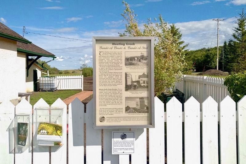
On 50th Avenue at 50th Street, on the left when traveling south on 50th Avenue.
The Meeting Creek depot was built by the Canadian Northern Railway in 1913 to a “Standard Third Class” plan issued by the company. It is typical of many “combination” railway depots used throughout North America – providing facilities for passenger . . . — — Map (db m197015) HM
On 50 Street (Provincial Highway 2A) just south of 49 Avenue, on the left when traveling south.
In 1879, it was assumed by many that the Canadian Pacific Railway would be built north-west across the prairies and pass Fort Edmonton on its way through the Yellowhead Pass. A small land rush took place about the fort, and the Edmonton Settlement . . . — — Map (db m214848) HM
On 50 Street at 51 Avenue, on the right when traveling north on 50 Street.
In 1891 the Calgary and Edmonton railway line was completed and Siding 16 was created. Later, because of a suggestion by Father Lacombe, it was named Wetaskiwin, which in Cree means "the place where peace was made." The trains that travelled . . . — — Map (db m206513) HM
On 50th Avenue at 47th Street, on the right when traveling east on 50th Avenue.
[English] Rapid settlement of western Canada after 1900 created an urgent need for new judicial facilities. The Wetaskiwin Court House was one of the initial group of public buildings constructed in Alberta after the shift from territorial to . . . — — Map (db m197022) HM
On 50th Avenue just west of 50th Street, on the right when traveling west.
The red brick building that most people know as the Old Post Office was built by the Federal Government in 1911, but it wasn't Wetaskiwin first Post Office. Until the completion of the Calgary & Edmonton Railway line in 1891, mail was delivered by . . . — — Map (db m197029) HM
On 56th Street (Provincial Highway 2A) at 50th Avenue, on the right when traveling north on 56th Street.
Driving towards Wetaskiwin from any direction, the 10-storey water tower is the first visible sign of the City. Like the prairie grain elevators, water towers have long been the signature landmarks of communities. Unfortunately, most of them have . . . — — Map (db m197030) HM
On 50 Avenue at 50 Street, on the right when traveling east on 50 Avenue.
The original building at this location was destroyed by the disastrous fire of 1903, and the building that replaced it was a very small wooden structure. In 1907, it was occupied by two real estate firms, Smith and Gibbs, and Bradley and Nickerson. . . . — — Map (db m280600) HM
On Broadway Avenue at Park Street, on the right when traveling north on Broadway Avenue.
One of Blackfalds first general stores called "The Pioneer Store"was built by John McKay around 1901. Not only did Mr. McKay do business with the newly arrived homesteaders, he traded with the local natives, baling up many hides to ship every . . . — — Map (db m212446) HM
On 47 Street (Provincial Highway 881) just north of 47 Avenue, on the right when traveling south.
Old Mannville was a cluster of commercial and residential buildings constructed on land originally homesteaded by Dan McLean. In anticipation of the arrival of the Canadian Northern Railway, J.B. Burch built a store here in 1904, along the . . . — — Map (db m206503) HM
On Provincial Highway 2A 0.5 kilometers south of Ermineskin Avenue, on the left when traveling south.
Who was Maskipeton? He was a Cree, born around 1807. He became chief and led a Cree band that hunted south of today's Edmonton, but that also ranged into Saskatchewan and Montana. He traded into the Missouri River area. He was a warrior, respected . . . — — Map (db m206506) HM
On 50 Street just west of Gaetz Avenue (50 Avenue), on the left when traveling west.
As you look at this structure, covered by a facade of glass and stucco, it's hard to imagine this is Red Deer's oldest building still located on its original site. Known as the Brumpton Store, it is reminiscent of a very different Red Deer — one . . . — — Map (db m206611) HM
On Gaetz Avenue (50 Avenue) just north of 51 Street, on the right when traveling south.
At the end of World War II, life was getting back to normal. Soldiers returned home from the battlefields, families were reunited and the strain of wartime was replaced by a tangible feeling of prosperity. Businesses in Red Deer flourished, and the . . . — — Map (db m206759) HM
On 51 Avenue (Provincial Highway 2A) at 50 Street, on the right when traveling south on 51 Avenue.
In the winter of 1890, the arrival of the Calgary and Edmonton Railway brought significant changes to the hamlet of Red Deer. Its strategic location midway between the larger centres positioned Red Deer as a focal point for the distribution of . . . — — Map (db m206609) HM
On 50 Street just west of Gaetz Avenue (50 Avenue), on the left when traveling west.
The smell of food wafting onto the street is as enticing now as it was when George Moon opened his first café in 1916. Had you been a patron of Moon's restaurant in the early years, you would have found that good food, plenty of company and a . . . — — Map (db m206694) HM
On 50 Street 0.1 kilometers west of 49 Avenue (Provincial Highway 2A), on the right when traveling west.
Hugh Farthing built this Prairie Vernacular style building in 1939. The main floor was used as his photography studio. The second floor had a six-roomed suite used as his residence. The signage was simply “Farthing’s.” Today the signage font and . . . — — Map (db m206763) HM
On Provincial Highway 2A at 50 Street, on the right when traveling south on Provincial Highway 2A.
Red Deer's population grew rapidly during the Second World War due to the construction of military training camps and the onset of Alberta's energy boom. In response to the city's growth, the Federal Building, which housed the post office, was . . . — — Map (db m197005) HM
On Gaetz Avenue (50 Avenue) just south of 50 Street, on the right when traveling south.
Is there a Roman influence in Red Deer? The Greene Block in front of you could make such a claim, as its origins can be traced to a Romanesque revival style of architecture that was pieced together with sandstone blocks from a local quarry. The . . . — — Map (db m206712) HM
On 50 Street just east of Gaetz Avenue (50 Avenue), on the right when traveling west.
In 1935, Mrs. Sadie Collins made the local newspaper when she offered cash to purchase this property on Ross Street. It was unusual for a woman to start a new business venture in the middle of the Great Depression, so Collins made the news several . . . — — Map (db m206778) HM
On Gaetz Avenue (50 Avenue) just north of 50 Street, on the left when traveling south.
The October 26, 1955, edition of the Red Deer Advocate stated there would be big changes in downtown Red Deer — the old Horsley Pharmacy building located at this corner would be torn down and a new Horsley Block would take its place. Richard Earl . . . — — Map (db m206841) HM
On 50 Street just east of Gaetz Avenue (50 Avenue), on the right when traveling west.
Mable Lee Fong and Herschell N. Bryant constructed this building in 1947 to house the Paris Cafe. This solid, simply detailed masonry building symbolized post war Red Deer. It replaced a 40 year old structure that had also served as the Paris Cafe. . . . — — Map (db m206876) HM
On 50 Street at Provincial Highway 2A, on the right when traveling west on 50 Street.
The austere brick walls and Tyndall limestone columns of the Old Court House convey a sense of awe. This was intentional, as the building's Classical Revival style was meant to give the impression of power and civilization – attributes designed . . . — — Map (db m197003) HM
On 48th Avenue at 49th Street, on the right when traveling south on 48th Avenue.
Built in 1914 in the Gothic Revival style, the Armoury was constructed as the headquarters of the 35th Central Alberta Horse Regiment. The Armoury served as a recruitment office and training centre for the Department of Militia and Defence for more . . . — — Map (db m197012) HM
On 50 Street west of Provincial Highway 2A, on the right when traveling west.
[First plaque]
In proud and grateful
remembrance of those
who made the supreme
sacrifice in the wars
1914 – 1918
1939 – 1945
1950 – 1953
[Second plaque]
If ye break faith
with us who die
we shall not sleep . . . — — Map (db m197000) WM
On 50 Street at Gaetz Avenue (50 Avenue) on 50 Street.
Rev. Dr. Leonard Gaetz, founder of Red Deer, gazes down main street. A Methodist minister from Nova Scotia, Rev. Gaetz came to the Red Deer Valley in 1884. He quickly distinguished himself as a farmer, and became an outstanding and eloquent . . . — — Map (db m206970) HM
On Gaetz Avenue (50 Avenue) just north of 50 Street, on the left when traveling south.
Standing at this spot in 1893, you would have heard whinnying horses and seen bustling activity at the North West Mounted Police stable. That year the police detachment moved from Fort Normandeau to the new community of Red Deer, and they built . . . — — Map (db m206882) HM
On Gaetz Avenue (50 Avenue) just south of 50 Street, on the right when traveling south.
Looking toward Ross Street on your right, you see the beautiful sandstone structure of the Greene Block. In front of you, the historic brick building connects with the one beside it, stretching all the way down to the corner. These three buildings . . . — — Map (db m206972) HM
On Viewpoint Road 0.6 kilometers north of Township Road 452 when traveling west.
Like many other communities in Alberta, Wainwright is where it is today because of a railway. The Grand Trunk Pacific Railway (GTPR) surveyed the townsite in 1908, forcing the moving of buildings from Denwood 2.5 miles to the new town. Following its . . . — — Map (db m197033) HM
On Viewpoint Road 0.6 kilometers north of Township Road 452 when traveling west.
West of Wainwright the railway met a deep challenge, a glorious valley that was home to the Battle River. In 1907, the concrete footings of the bridge that would span the valley were poured. Farmers and other contractors hauled supplies to the site . . . — — Map (db m197037) HM
On 10 Street at 2 Avenue, in the median on 10 Street.
[World War I plaque]
These went and came not again
In memory of those from
this community who gave
their lives in the Great War.
H.C. Barss • J. Berry • P.A. Conneau • J. Coutts • J. Crompton • A. Dalton • J. Edmonds • J. Elliott • . . . — — Map (db m197042) WM
On 2 Avenue just east of 10 Street, on the left when traveling east.
Old Town Hall is a neo classical two storey brick building built in 1929. Prominent features of this style include the building's symmetrical facade, decorated cornice with dentil detailing and decorate lintels above the window and door openings. . . . — — Map (db m197041) HM