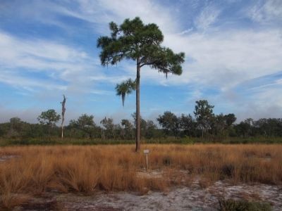
This leisurely 10 minute, 1/4 mile long trail will lead you to the site of Fort Chokonikla built in late 1849. It consisted of three square blockhouses for defense, and canvas tents for sleeping. No battles were fought here and it was abandoned . . . — — Map (db m62019) HM WM
On West Main Street west of South 9th Avenue, on the left when traveling west.
On January 18, 1907, the Hardee County Courthouse property was conveyed to the City of Wauchula for the sum of $300. The city deeded the property to the county on September 22, 1927.
The building is an imposing structure with Tuscan columns . . . — — Map (db m278014) HM
On South Florida Avenue 0.2 miles north of Altman Road, on the left when traveling north.
Named in honor of Lt. George C. Hartsuff 2nd Artillery, U.S.A., whose detachment of men were ambushed in the Big Cypress Swamp, December 20, 1855, by the Seminole Indians killing several men and wounding many others.
Fort Hartsuff was a . . . — — Map (db m110528) HM
On East Main Street at North 6th Avenue, on the right when traveling west on East Main Street.
In 1915, Harry Stansfield, a native of England, and Dr. Y.E. Wright erected the two-story building to serve as the home of Orange Pharmacy. The mezzanine gallery was white with mahogany furnishings. Citizens admired the marble soda fountain and the . . . — — Map (db m277971) HM
On West Main Street (Florida Route 636) at North 9th Avenue, on the right when traveling west on West Main Street.
In 1912, William B. Beeson, Sr., a lawyer and teacher, and his wife , Katherine Chambless Beeson, built their family home on Main Street. The fourteen-room house was one of the largest in Wauchula at the time. Lumber was hauled by wagon from . . . — — Map (db m290477) HM
On East Main Street at Noth 4th Avenue, on the left when traveling east on East Main Street.
The City Hall of Wauchula was built in 1927 at a cost of $80,000. Regionally known architect M. Leo Elliot utilized a Spanish design for the building, which contained city offices, an auditorium, and the fire department complex in the rear.
The . . . — — Map (db m277997) HM
On East Main Street at South 6th Avenue, on the right when traveling east on East Main Street.
Established in 1907, Wauchula’s Second Bank, the Bank of Wauchula, opened for business. This building was constructed in 1913 with the bank and store rooms occupying the ground floor and professional offices and the Seminole Theater above. The bank . . . — — Map (db m277955) HM
On North George Burris Avenue at East Main Street ( Road 636), on the right when traveling north on North George Burris Avenue.
In 1886, Florida Southern Railway purchased the right of way for the train tracks. By 1889, the town had a full-time depot master, regular train service and a wooden train depot. Railroad personnel named the train stop Wauchula, using a . . . — — Map (db m290478) HM
"Bone" Mizell
was DeSoto County's wag, prairie philosopher, cowboy humorist and prankster. He was beloved for his merrymaking. Bone was christened
Morgan Bonapart Mizell
He was born 1863 and died 1912. Bone is buried in Joshua Creek . . . — — Map (db m24589) HM
Near Wilber C. King Boulevard (U.S. 17) 0.1 miles north of Florida Cracker Trail ( Route 64), on the left when traveling north.
Born April 17,1876
In Millerstown, KY.
Owned an operated this Blacksmith Shop in Bowling Green, Fla. from 1897 until his death - July 13, 1953.
This shop stood as a historical landmark in Hardee County and was donated to Hardee County . . . — — Map (db m288308) HM
One of the Last Battles fought with the Seminole Nation ended here on June 16, 1856 with Defeat of the Indians by Soldiers from Ft. Meade. — — Map (db m61059) HM
The Seaboard Coastline Railroad deeded the old depot built in 1926 to the City of Avon Park in 1979. the building was leased to the Historical Society of Avon Park. The Depot Museum was created and dedicated in 1981. in 1986 a railroad dining car . . . — — Map (db m218001) HM
On West Main Street at Forest Avenue, in the median on West Main Street.
In Honor of all who served in World War II from this community and dedicated to lasting memory of those who lost their lives
Abbot, James C. • Adams, Robert C. • Anderson Allen M. • Anderson James W. • Anderson, Robert A. • Andreu, Robert A. . . . — — Map (db m218316) WM
On Jim Rodgers Avenue at Robert Britt Street, on the right when traveling south on Jim Rodgers Avenue.
Here stands the first church built in the settlement of Avon Park. On 9, 11, 1892, the first services were held in the nearly completed Union Evangelical Church. The 36 feet by 42 feet structure, with a small tower. had been under construction . . . — — Map (db m218010) HM
"Off with your hat as the flag goes by! Uncover the youngster's head! Teach him to hold it holy and high. For the sake of its sacred dead." Bunner — — Map (db m218002) HM WM
On East Main Street (Florida Route 17) east of South Lake Avenue, on the right when traveling east.
This is the oldest structure on Main Street still retaining most of it's original features. Built in 1894, it has served as a shoe shop, Dressmaker's shop, Tea Room, Book Store, Art Studio, and an Attorney's Office. The architecture present is . . . — — Map (db m218007) HM
On West Main Street (Florida Route 17) at Forest Avenue, in the median on West Main Street.
Ester Adams • Richard Adams • Tommy Alford • Willie Allen Jr • Robert Ambrose • Michael Andres • Randell Andrews • David Annis • Jeffrey Antley • Mark A. Appenzellar • Michael Aquino • Brain Arabinko • Clifford Armstrong • Charles Asbury • Samuel . . . — — Map (db m218313) WM
On U.S. 98 0.1 miles north of County Road 721, on the right when traveling north.
Col. Zachary Taylor had Fort Basinger built in 1837, during the Seminole Wars, on the Kissimmee River 17 miles above its mouth. It was a small stockade which served as a temporary fort and supply station on the line of forts extending from Tampa to . . . — — Map (db m54083) HM
Three Decades of Growth During the time that Frances Archbold Hufty was Chairman of the Board (1976 to 2010), Archbold Expeditions acquired additional properties and expanded its programs, strengthening the links among research, . . . — — Map (db m224264) HM
Frances Archbold Hufty Frances Archbold Hufty (1912 to 2010) became Chairman of the Board of Archbold Expeditions in 1976 after her brother, Richard Archbold, bequeathed his assets to the organization shortly before his death. During the 35 . . . — — Map (db m224260) HM
On Park Drive at West Interlake Boulevard, on the left when traveling south on Park Drive.
Francis Scobee • Ellison Onizuka • Michael Smith • Ronald McNair • Judith Resnick • Gregory Jarvis • Christa McAuliffe
”World’s keep closing in they have before, they will again voices call beyond the wind saying we must go, beyond . . . — — Map (db m218231)
On East Park Street west of Service Avenue, on the left when traveling west.
Joshua B. & Louisa G. Lastinger
1847-1931 · 1848-1931
First homesteader and citrus grower on Lake Stearns, 1890
Dedicated August 29, 1987 — — Map (db m218329) HM
On West Park Street at Service Avenue, on the right when traveling west on West Park Street.
The Atlantic Coast Line Railroad depot was built at the urging of Dr. Melvil Dewey. He
then petitioned the state to have the town's name changed from Lake Stearns to Lake Placid, as it was a winter residence for the Lake Placid Club of New York. . . . — — Map (db m214350) HM
On Blessings Avenue at U.S. 98, on the right when traveling east on Blessings Avenue.
The first school house in the Lorida community, the Sunnyland School, was built on this site in 1925. A 1933 hurricane destroyed the school, and the Civilian Conservation Corps rebuilt it using the original plans and identical materials. The school . . . — — Map (db m229355) HM
On Park Loop Drive 0.4 miles west of Hammock Road (County Road 634), on the right when traveling west.
Alla Cordilla Hancock married William L. Eiland in 1889. Around 1900, they settled on five acres adjoining the Skipper homestead. Cordie, as she was known, was Jonathan Skipper's cousin. In 1902, W.L. and Cordie purchased eighty acres of property . . . — — Map (db m299191) HM
On Lakeview Drive at Highland Road, on the right when traveling north on Lakeview Drive.
Dedicated to all men and women wounded in all our wars
My stone is red for
the blood they shed.
The medal I bear
is my country’s way
to show they care
If I could be seen
by all mankind
maybe peace will
come in my lifetime. . . . — — Map (db m247742) WM
Near Hammock Road (County Road 634) 1.1 miles west of County Road 635, on the left when traveling west.
Dedicated to the Memory of Emil Billitz Sr. and countless other C.C.C. enrollees who were injured, disabled or lost their lives in performance of their duty. We especially remember the 228 C.C.C. members who perished September 2, 1935 during a . . . — — Map (db m72742) HM
Built by Sebring Real Estate Company 1923 2nd floor served as first Highlands County Courthouse from 1923 to 1927 This property has been placed on the National Register of Historic Places — — Map (db m218113) HM
Near Midway Drive 0.2 miles east of Hayward Taylor Boulevard, on the left when traveling east.
This original 72’ flagpole at the Sebring International Raceway marks the geographic center of Hendricks Field, a United States Army Air Force (USAAF) base that operated under the jurisdiction of the 76th Flying Training Wing from 1942-1945. . . . — — Map (db m134905) HM
On Park Loop Drive 1.6 miles west of Hammock Road (County Road 634), on the left.
Purchased by the late Margaret Shippen Roebling (Mrs. John A. Roebling) To make accessible and to conserve in their natural state the vegetation and all forms of animal life herein. In her memory the officers and directors of . . . — — Map (db m299194) HM
On Circle Park Drive at Ridgewood Drive, on the left when traveling north on Circle Park Drive.
This memorial to Sebring area men
who died in our Country's Service
Erected by Sebring Firemen, Inc.
A W "Spizz” Pollard and
concerned citizens 2000
★★ Donors ★★
Joe & Louise Stiles • “Butch" Tew • Lillian . . . — — Map (db m218227) WM
John Mihalowski MA USN 1939
James H. Howard China AAC 1944
Everett P. Pope MA USMC 1944
James R. Hendrix AR USA 1944
Joseph J. McCarthy IL USMC 1945
Douglas T. Jacobson NY USMC 1945
William R. Charette MI USN 19563
Ronald E. . . . — — Map (db m218229) HM WM
On North Ridgewood Drive (Florida Route 17) at North Mango Street, on the left when traveling north on North Ridgewood Drive.
Highlands County is a subtropical paradise where George Sebring founded a new town in 1912. In 1923 Mr. Sebring welcomed Mike and Sadie Kahn & a strong friendship formed. They opened a store on Ridgewood Drive & Mr. Sebring gave Mike a lot for a . . . — — Map (db m157299) HM
Near West Center Avenue at Circle Park Drive when traveling east.
Founded 1912 in old Desoto County by George E. Sebring and his son, H. Orvel Sebring, of Ohio. That year saw the first railroad and early citrus plantings. In 1921 Highlands County was formed with Sebring as County Seat. The founders devoted their . . . — — Map (db m160795) HM
Now the Greater Sebring Chamber of Commerce Built in 1916 through a community effort This property has been placed on the National Register of Historic Places — — Map (db m218667) HM
On Park Loop Drive 0.4 miles west of Hammock Road (County Road 634), on the right when traveling west.
In 1881, Jonathan Skipper settled in this forest known as “Hooker’s Hammock.” He and wife Letitia, purchased claim to this property, cleared land for their home, planted orange trees, and built livestock holding pens. He also gave five acres of . . . — — Map (db m299192) HM
On South Commerce Avenue south of South Orange Street, on the left when traveling south.
In honor of The U.S.S. Highlands (APA 119) and Her Gallant Crew For service in the Pacific during WWII donated by The Citizens of Highlands County Dedicated October 5, 1993 — — Map (db m157289) WM
Near Cottage Drive south of Main Drive, on the left when traveling south.
These buildings were designed and built during 1930-1935 by Alexander Blair for the Red Hill Estate of John A. Roebling II, son of Washington A. Roebling, who built the Brooklyn Bridge. The industrial vernacular buildings (structures meant to house . . . — — Map (db m72522) HM
Near Main Drive west of Old State Route 8, on the left when traveling west.
It Began with a Gift
1941, aviator and biological explorer Richard Archbold acquired the Red Hill Estate as a gift from John A Roebling II. As World War II raged in the Pacific, Archbold began to implement ideas for a biological field . . . — — Map (db m218950) HM
Near Main Drive west of Old State Route 8, on the left when traveling west.
The Founding of Red Hill
In the 1920s, people came to Florida for many of the same reasons they do today, seeking mild winters and the beauty of Southern getaway. The Lake Placid Club of New York established its Florida resort on Lake . . . — — Map (db m218949) HM
Near County Road 445 5 miles east of State Highway 19 when traveling north.
Marjorie Harris Carr - Tireless Conservationist Marjorie Harris Carr's most prominent legacy on the byway was to halt the construction of the Cross Florida Barge Canal. Over the long 1962-1971 battle, she enlisted citizen's groups, formed an . . . — — Map (db m131087) HM
Near Main Street (Florida Route 19) at Clark Road, on the right when traveling north.
Robert M. McTureous, Jr. Private United States Marine Corps Born: March 26, 1924 Killed in Action: June 1945 Awarded his country’s highest award The Medal of Honor ”For conspicuous gallantry and intrepidity at the risk of his life above . . . — — Map (db m167318) WM
On Florida Avenue (County Road 48) just east of Van Buren Street, on the left when traveling east.
This Cemetery was a gift to the Town of Astatula from Mary C. Hux and was deeded to the town on October 11th, 1895. The deed stipulates that the Cemetery property, which is roughly 10 acres in area, will only be a Cemetery and that it would always . . . — — Map (db m165276) HM
Near Front Street/Blackwater Lane just south of Butler Street ( Route 40).
A wide diversity of people have traversed this spot on the St. Johns River, starting with the ancient tribes and Timucuan and Mayacan Indians. The St. Johns River was named one of fourteen American Heritage Rivers because of its importance to the . . . — — Map (db m188477) HM
On State Road 40 0.3 miles west of the Astor Bridge, on the right when traveling east.
Located on the west bank of the St. Johns, Ft. Butler was built in 1838 during the Seminole Wars. It consisted of a crude log stockade and barracks for the garrison. The Fort was one of the military installations designed to protect the St. Johns . . . — — Map (db m31341) HM
Near West Avenue at West Osceola Street, on the right when traveling south.
The sign from Clermont High School (formerly located at 301 East Avenue) serves as a reminder of our rich heritage and perseverance in providing education for the children of Clermont. Clermont's schools date back to 1881 when school was held in a . . . — — Map (db m228410) HM
Lt. Gilmore's P-51B Propeller Tip. In honor of Dean R. Gilmore, 1st LT USAAF, 14 Nov 21 - 14 Nov 44. Winner of the Distinguished Flying Cross, Italy, 1944. Killed in a training crash in Lake Louisa on November 14, 1944. Lt. Gilmore and thousands of . . . — — Map (db m62012) HM WM
On 3rd Street at West Minneola Avenue, on the left when traveling north on 3rd Street.
In Memory of
William Alfred Suggs
Born Jan. 1, 1919
Died Dec. 7, 1941
at Pearl Harbor
on USS Arizona
VFW Post 5277
Clermont, FL — — Map (db m244285) WM
Near Ferran Park Drive at East McDonald Avenue, on the right when traveling south.
Originally built in 1926 facing Magnolia Avenue, relocated to present site and enlarged in 1936, refurbished in 1992, placed on the National Register of Historic Places by the United States Department of the Interior, June 23, 1994. — — Map (db m166230) HM
Near Ferran Park Drive at East McDonald Avenue, on the right when traveling south.
In memory of the soldiers and Army nurses from the Golden Triangle Area who participated in the Battle of the Bulge, 16 December 1944 through 25 January 1945 in Belgium and Luxembourg. This major conflict with the German armies is regarded as the . . . — — Map (db m166537) HM WM
Near North Bay Street (Florida Route 19) at Gottsche Avenue, on the right when traveling south.
Custom boat building was one of the early businesses in Eustis. Bassett Boats Works, founded in 1926, constructed some of the first outboard powered cabin cruisers and the first powered glass-bottom boats famous at Silver Springs. Pilings from this . . . — — Map (db m166237) HM
On North Bay Street (Florida Route 19) just south of Northshore Drive (Bates Avenue), on the right when traveling south.
David Mathieson Walker was an Eagle Scout and 1962 graduate of Eustis High School. After graduating from the United States Naval Academy, he went on to become a naval aviator and highly decorated veteran of the Vietnam War. In 1978, he was selected . . . — — Map (db m207683) HM WM
Near Northshore Drive 0.1 miles west of North Bay Street ( Route 19) when traveling west.
Completed in 1911, this large neo-classical house is constructed of Florida cypress. Originally home to Guilford D. Clifford, one of the town’s earliest settlers and businessmen, this is now headquarters of the Eustis Historical Museum and . . . — — Map (db m166241) HM
Near Ferran Park Drive at East McDonald Avenue, on the right when traveling south.
Born May 23, 1866 in Sunderland, Massachusetts, Dr. Banks was educated at Amherst College and Harvard. He received a Ph.D. from the University of Breslau in Archeology and Semitic Studies and was a prolific author and writer. He was appointed an . . . — — Map (db m166233) HM
Near North Bay Street (Florida Route 19) at Hazzard Avenue, on the right when traveling south.
The four streets leading to the entrance ramps of the Lake Walk are named Bates, Hazzard, Gottsche, and Clifford. Charles H. Bates, Joseph De V. Hazzard, Augustus Gottsche, and Guilford D. Clifford were elected to the first Town Council after the . . . — — Map (db m166239) HM
On East Magnolia Avenue at North Eustis Street, on the right when traveling west on East Magnolia Avenue.
Before railroads reached central Florida, long distance travel and shipping relied on steamboats, and early settlements that were concentrated along navigable waterways. Steamboats along the St. Johns River connected Eustis with Mellonville (today . . . — — Map (db m311699) HM
Near North Bay Street (Florida Route 19) at West Clifford Avenue, on the right when traveling south.
Ferran Park was formed in 1921 from sand pumped from the bottom of Lake Eustis and retained by a bulkhead constructed at the waters’ edge. It was named for E.L. Ferran, a pioneer businessman and civic leader. In 1994 the park was placed on the . . . — — Map (db m166236) HM
Near Ferran Park Drive at East McDonald Avenue, on the right when traveling south.
Special thanks to Florida Hospital Waterman • United Southern Bank • Golden Triangle V.F.W. Post 8087 • Harden-Pauli Funeral Home • Bank First • Neil Fischer Realty • Regina & Richard DeMarco & Family • Merrilyn & Daniel DiVenanzo & Family • Rick . . . — — Map (db m166549) WM
On West Orange Avenue just west of Ferran Park Drive, on the right when traveling west.
Since the times when steamboats were the most popular form of transportation across Lake Eustis, the city has been a hub of commerce. In eighteenth century Eustis, a boat landing on the lake at the foot of McDonald Avenue was the primary shipping . . . — — Map (db m311698) HM
Near Ferran Park Drive at East McDonald Avenue, on the right when traveling south.
This memorial is to honor the loving memory of the service Men and Women of Lake County, Florida, both living and dead, whose services and supreme sacrifices in the cause of liberty gives us the full meaning of patriotism. This memorial made . . . — — Map (db m166541) WM
Near North Bay Street (Florida Route 19) at Gottsche Avenue, on the right when traveling south.
Lake Eustis was named for Colonel Abraham Eustis, First Commander of U.S. Army forces in Florida. The city of Eustis was briefly named Lake Eustis, but the word “Lake” was dropped in 1883 when the town was incorporated. The lake is about 12 square . . . — — Map (db m166238) HM
Near North Bay Street (Florida Route 19) at West Clifford Avenue, on the right when traveling south.
The Alice B. McClelland Memorial Band Shell in Ferran Park was built in 1926 by William S. McClelland in memory of his wife. One of two historic Florida band shells still standing, it was restored in 1992 and named to the National Register of . . . — — Map (db m166235) HM
Near Northshore Drive 0.1 miles west of North Bay Street ( Route 19) when traveling west.
The lakefront was the hub of early Eustis. Businesses, Eustis Park, the railroad station, bathing beaches, marinas and public docks brought people to the waterfront. Boating activities of every sort from pleasure cruises to regattas were popular. . . . — — Map (db m166242) HM
Near Ferran Park Drive at East McDonald Avenue, on the right when traveling south.
Born in Tallahassee, 1916. Graduated from Florida A&M University, 1937, BS Degree. Continued his career as Principal of J.R.E. Lee High School, Wildwood and then at Carver Heights High School, Eustis. Recognized for his efforts to improve . . . — — Map (db m166231) HM
On North Bay Street (Florida Route 19) just south of Northshore Drive (Bates Avenue), on the right when traveling south.
To commemorate the beginning of scientific citrus breeding this tangelo, variety Orlando, is one of the many new citrus varieties produced in Eustis by H. J. Webber, W. T. Swingle, F. W. and E. M. Savage of the United States Department of . . . — — Map (db m312000) HM
Near North Bay Street (Florida Route 19) at Hazzard Avenue, on the right when traveling south.
By 1912 a building called The Pavilion had been constructed on pilings in Lake Eustis. A pier 250 feet long connected it to shore where Clifford/MacDonald Street ended. The Pavilion served as a community center where parties, dances, and band . . . — — Map (db m166240) HM
Near County Road 44 0.4 miles east of State Route 19, on the right when traveling east.
'Chippers' began the turpentine process by slashing a "cat face" into the tree. Bleeding sap is directed by a tin strip to a box, or later a 'Herty' pot, hung below the scars. 'Dippers' visited the trees every 7 to 12 days (based on the season and . . . — — Map (db m213515) HM
Near County Road 44 0.4 miles east of State Route 19, on the right when traveling east.
"Turpentining" is the process of extracting sap or resin from longleaf pine trees and distilling it to create pitch. During the process, turpentine spirits and various grades of solid rosin were also produced. The majority of pitch was used to . . . — — Map (db m213513) HM
Near North Center Street just south of East Clifford Avenue, on the right when traveling north.
This property has been placed on the National Register of Historic Places by the United States Department of the Interior August 5, 1991 — — Map (db m166527) HM
Near Wolfs Head Road 0.5 miles north of County Road 455.
Lake Apopka has been home to generations of people who settled in this area. Over the years, the Lake has thrived and fallen into decline. It is now in recovery and revival since the 1990s, and is central to the Green Mountain Scenic . . . — — Map (db m165283) HM
On Spring Lake Road at Marjorie Street on Spring Lake Road.
Founded in 1886 by a group of young English men who came to this area to plant citrus groves, this church was opened in December, 1888. Earlier services were held at a barn on nearby Lake Geneva, midway between Fruitland Park and Chetwynd, a town . . . — — Map (db m72624) HM
On West Berckman Street at Rose Avenue (County Road 468), on the right when traveling west on West Berckman Street.
In 1914, George T. Clark built a community center for the residents of Fruitland Park on the property of his Gardenia Hotel. Known locally as the Casino, the building was designed in the Frame Vernacular style with wood-framed construction, a metal . . . — — Map (db m131265) HM
You are not Forgotten Deceased KWVA Chapter 188 Member 11/17/2011 George McKinney 2001 • Maurice Case 2003 • Marty Abramowitz 2005 • G P Sloan 2005 • Nelson Detwiler 2006 • Don Sams 2006 • Andy Kraycirik 2006 • Hans Krieger 2006 • I W . . . — — Map (db m219533) HM WM
(Side 1)
Constructed in 1937 during the Great Depression, Groveland High School, home of the Greenbacks, was built as part of the national Work Progress Administration (WPA) projects. The original building contained first through twelfth . . . — — Map (db m67026) HM
On South Lake Avenue, on the left when traveling south.
In Honor of our Vietnam Veterans November 1, 1955 - April 30, 1975 Thank you for your Service Welcome Home [Supplemental Plaque - Granite donated by Granites Best, LLC of Mascotte Engraving by Kevin Toole of JTS Enterprises SE, . . . — — Map (db m219537) WM
On Lake Emma Road, on the left when traveling east.
On this site in 1885, George Thomas King, founder of Villa City, built an estate that was the showplace of the area. By 1895, the town had a post office, school, church, hotel, photographic studio, dispensary and 35 homes. The citrus based community . . . — — Map (db m67024) HM
On North Palm Avenue (Florida Route 19) just north of North Citrus Avenue, on the right when traveling north.
William J Howey William J. Howey, born January 19, 1876, was among the foremost citrus land
developers in early 1900s Florida. He created his first development in Winter
Haven in 1908, opening new groves in the area every two years after . . . — — Map (db m312946) HM
Near U.S. 441 at West McClendon Street, on the right when traveling south.
On February 2, 2007, Lake County experienced one of its most devastating disasters. In addition to hundreds of damaged homes and millions of dollars in destruction, 21 individuals lost their lives in the communities of Lady Lake and Lake Mack. . . . — — Map (db m219528) HM