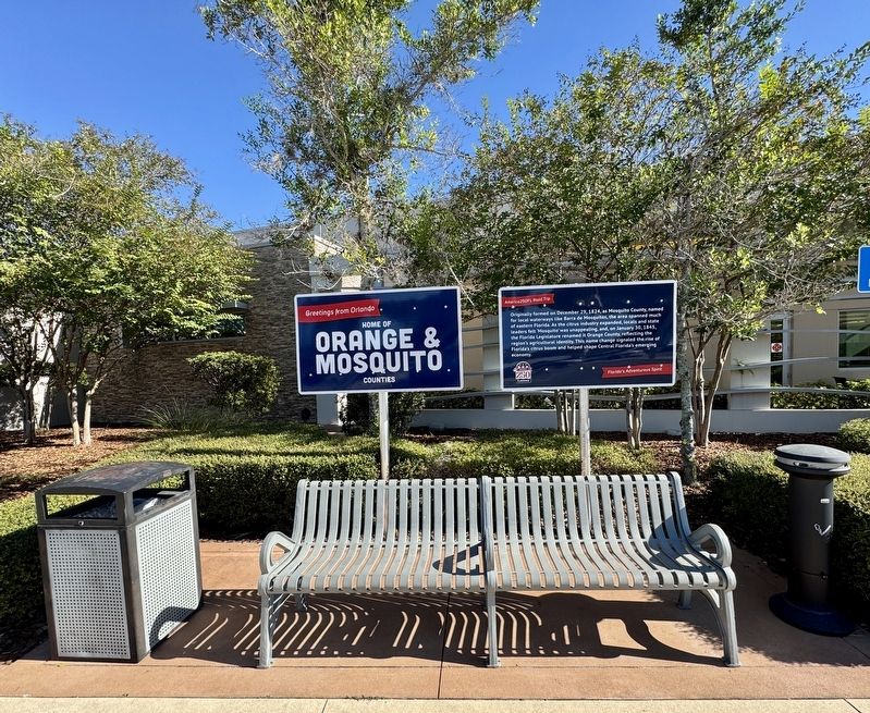
Near Florida's Turnpike (at milepost 263), 2 miles south of Spessard L Holland Expressway (Florida Route 408), in the median.
Originally formed on December 29, 1824, as Mosquito County, named for local waterways like Barra de Mosquitos, the area spanned much of eastern Florida. As the citrus industry expanded, locals and state leaders felt 'Mosquito' was unappealing, . . . — — Map (db m288056) HM
Near Jay Blanchard Trail 0.5 miles west of Rouse Road, on the right when traveling west.
One of five structures built by Orange County Public Works for flood control in the Little Econlockhatchee River Completed in 1965 Orange County Government Florida — — Map (db m170338) HM
On W Central Boulevard 0.1 miles N. Court Street, on the left.
These flags fly in honor and memory of those who lost their lives and loved ones in the attacks on our cherished American freedoms that took place in New York City, Washington, D.C. and Southwestern Pennsylvania on 9/11/2001
Dedicated . . . — — Map (db m138803) WM
On U.S. 41 1.1 miles north of Oak Street (Northwest 9th Street), on the left when traveling north.
Dedicated to the memory of Michael McKenzie Smith Member State Road Department of Florida 1915-1919, Chairman 1919-1920 Born Dec. 20, 1863 Tattnall County Georgia Died July 6, 1929 Winter Park, Florida ————— He visioned and created a . . . — — Map (db m234449) HM
On Wekiva River Road 0.1 miles south of Chipola Trail, on the left when traveling south.
The first settlers in Florida were Paleo-Indians who arrived about 14,000 years ago. These hunters and gatherers built their settlements near springs. At least a dozen campsites have been documented along the Wekiva River and Rock Springs Run.
. . . — — Map (db m265284) HM
On South Binion Road (State Road 437) 0.8 miles west of Ocoee-Apopka Road (County Road 437A), on the right when traveling south.
In the 1870s, the early settlers of northwest Orange County looked to area waterways as commercial highways. Lake Apopka, the head of the Ocklawaha chain of lakes, offered access to the St. Johns River near Palatka and a way for citrus and vegetable . . . — — Map (db m72409) HM
Near Summerlin Avenue at Gatlin Avenue, on the right when traveling north.
Fort Gatlin's Early Settlers
A small civilian population concentrated around Fort Gatlin as a result of the Armed Occupation Act of 1842. The Act offered 160 acres to anyone who stayed five years, built a cabin, cultivated five acres of . . . — — Map (db m220784) HM
On Gatlin Avenue at South Summerlin Avenue, on the left when traveling east on Gatlin Avenue.
On November 9, 1838, during the Second Seminole Indian War (1835-42), the U.S. Army established Fort Gatlin in Mosquito County. This fort was named for Army Assistant Surgeon John S. Gatlin (1806-1835), who was killed in the Dade Massacre in 1835. . . . — — Map (db m6912) HM
On Brick Road at Tildenville School Road, on the right when traveling west on Brick Road.
Paved in brick, this stretch of State Road 22 evokes a brief but important era in Florida transportation. As the nation swapped horses for automobiles, states struggled to update their roadways; here in Florida, narrow car tires had turned roads of . . . — — Map (db m160889) HM
This road was the first direct route from Northeast Florida to Maitland. It followed Maitland Avenue around this west side of Lake Lily and continued south on what is now Highway 17-92. During the Second Seminole War the United States Army used this . . . — — Map (db m13636) HM
Near Harrell Road 0.4 miles north of East Colonial Drive (Florida Route 50), on the left when traveling north.
One of five structures built by Orange County Public Works for flood control in the Little Econlockhatchee River Completed in 1968 Orange County Government Florida — — Map (db m170339) HM
Near East Colonial Drive (Florida Route 50) west of Central Park Avenue, on the right when traveling west.
One of five structures built by Orange County Public Works for flood control in the Little Econlockhatchee River Completed in 1970 Orange County Government Florida — — Map (db m170340) HM
Near Babb Road 0.2 miles north of Princess Lane, on the right when traveling north.
Similar to many 19th century rural homes in Florida, the Cadmans kitchen was separate from the main house for practical reasons. Cooking and fires created smoke and heat that would be unwelcome in the living areas of the house. The kitchen was . . . — — Map (db m220312) HM
On North Central Avenue (State Road 419/434) at Railroad Street, on the left when traveling north on North Central Avenue.
In the late 1860's Confederate veterans and freed slaves from the war-devastated South began to move into the settlement called "the Lake Jesup Community," to be joined later by others from Northern states and from Sweden. One of the Swedish . . . — — Map (db m93011) HM
On Edgewater Drive just east of Rose Avenue, on the right when traveling north.
Side 1
The Mississippian People and their descendants, including the Timucua, Tocobaga, Miccosukee, and Seminole, lived among these lakes and rivers for millennia. They called it “Wekiva,” meaning “spring of water” in the Muscogee language. In . . . — — Map (db m267776) HM
On Wekiva River Road 0.1 miles south of Chipola Trail, on the left when traveling south.
Settlers would often fashion their own furniture from wood and as families grew, cabins would be extended or replaced with a bigger structure. Cooking was done outside, as indoor cast-iron stoves were too expensive for most families to afford. . . . — — Map (db m265386) HM
Barber / Mizell Feud
Moses Barber moved his family from Georgia to northern Florida in 1833 and settled near the present Macclenny. They developed one of the largest cattle empires in the state but, during the Civil War (1861-1865), their . . . — — Map (db m251300) HM
On Alamo Drive at 29th Street, on the left when traveling south on Alamo Drive. Reported missing.
Aaron Jernigan moved to what is now Orlando in 1843 after the passage of the Armed Occupation Act of 1842 that opened vast areas of Florida for settlement. According to the law, one could move onto land at least two miles from an established . . . — — Map (db m217596) HM
On Rouse Road south of Riverbank Boulevard, on the right when traveling south.
This family cemetery stands on land that was originally part of 77 acres that was homesteaded by the Drawdy family, made possible by the Homestead Act of 1862. Two acres were set aside for a cemetery for the Drawdy family and local pioneers. . . . — — Map (db m219445) HM
On Bentley Street at North Westmoreland Drive, on the right when traveling west on Bentley Street.
In the summer of 1916, a few Black families from the Deep South settled in an area of Orlando called the Black Bottom, so named because when it rained, water settled in the area and remained so long that residents built canoes for transportation. As . . . — — Map (db m128317) HM
On East Central Boulevard at Court Avenue, on the right when traveling west on East Central Boulevard.
Lynching of July Perry
November 3, 1920
On Election Day, November 3, 1920, black residents in the Ocoee area who owned land and businesses were eager to vote. Despite a terrorizing Ku Klux Klan march through the streets of . . . — — Map (db m137336) HM
Near Greenwood Street 0.3 miles east of South Mills Avenue when traveling east.
(side 1)
Buried here are members of the Eppes and Shine families, descendants of President Thomas Jefferson, the author of the Declaration of Independence and the Statute of Virginia for Religious Freedom, and the father of the University . . . — — Map (db m93096) HM
On West 7th Avenue west of Main Street, on the right when traveling west.
Opened in 1887, this structure is the only surviving one-room school house in Orange County, and one of the few still standing in Florida. The Frame Vernacular building, capped with a metal roof, was communally constructed using locally milled . . . — — Map (db m93069) HM
In 1888, Lt. Col. William Edwin Cadman of Yorkshire, England, came to Narcoossee to investigate a potential investment property, including a home and citrus grove. Several members of the family joined him, including his wife, Jane. Upon their . . . — — Map (db m236257) HM
Near Bush Boulevard west of South Orlando Drive (U.S. 17/92), on the left when traveling west.
Mosquito County was established in 1824 by the U.S. Legislative Council. Mosquito County's name was changed to Orange in 1845. Seminole County was established in 1913 by the Florida Legislature when it was partitioned from Orange County, with . . . — — Map (db m52365) HM
When Lt. Colonel William Cadman purchased an orange grove in Narcoossee in 1888, he was retired and busy with many interests. The grove was likely an investment in his sons' futures, and they handled much of the work along with paid seasonal . . . — — Map (db m220311) HM
Prior to the late 1880s, travel was completed primarily by foot, horse, or wagon. After the expansion of railroad lines through Florida, convenient transportation became affordable to more of the population. Travel time was still slow, but railroads . . . — — Map (db m220309) HM
On Main Street north of 3rd Street, on the right when traveling north.
In 1843 Enterprise became county seat of Mosquito County, organized December 29, 1824, and changed to Orange County in 1845. On Dec. 29, 1854 the part of Orange County east of the St. John's River became Volusia County with Enterprise as County . . . — — Map (db m276893) HM
On South Conway Road (State Road 15) just south of Lake Margaret Drive, on the right when traveling south.
The English Colony
A group of Englishmen known locally as the English Colony immigrated to Conway in the 1880s. They came as a result of a land and citrus industry promotion by the state and railroad corporations that promised an annual . . . — — Map (db m101054) HM
On East Kennedy Boulevard at North College Avenue, on the right when traveling east on East Kennedy Boulevard.
The Robert L. Hungerford Normal and Industrial School was founded in 1889 as the first school for African Americans in Central Florida. Modeled after, Tuskegee Institute, a school started by Booker T. Washington in Tuskegee, Alabama, the mission of . . . — — Map (db m196810) HM
On West Princeton Street 0.1 miles east of North Westmoreland Drive, on the right when traveling north.
John Watts Young, NASA astronaut, Gemini veteran, Apollo moonwalker, and space shuttle commander, was the first American to travel in space six times. As an Orlando High School student, Young lived in this house at 815 West Princeton Street from . . . — — Map (db m72371) HM
On Wilma Street south of West Church Avenue, on the right when traveling north.
(side 1)
Mr. E.W. Henck, a young man from Boston, arrived in this wilderness section of then Orange County in November 1872. He selected a site to homestead in what is now Historic Longwood. Intent on establishing a town, he named it . . . — — Map (db m92975) HM
Near New York State Route 17A 0.4 miles Gibson Rd (County Route 100), on the right when traveling south.
Built in the 1700’s and used continuously as a school until 1936 when purchased by Minisink Chapter, NSDAR.
N.Y. State and National Register of Historic Places — — Map (db m29728) HM
On Baptist Camp Road north of East Kelly Park Road, on the right when traveling north.
Rock Springs is the source of the Rock Springs Run, a swift running stream with an average flow of 26,000 gallons per minute and a constant temperature of 68 degrees. The spring flows from limestone containing fossils that date back 17 million . . . — — Map (db m94341) HM
Near North Fort Christmas Road (County Route 420) 0.1 miles north of Christmas Cemetery Road, on the left when traveling north.
During the Second Seminole War General Eustis, U.S. Army, under the command of General Thomas S. Jesup, moved a column south from Fort Mellon (Sanford, Florida) on the 17th of December 1837. The column consisted of the 3rd Regiment of Artillery, 4 . . . — — Map (db m208532) HM
Near Freedom Avenue 0.3 miles south of Parker Street, on the right when traveling south.
The Ocoee massacre was a violent race riot that broke out on November 2, 1920, the day of the quadrennial U.S. Presidential election in Ocoee, Florida, African-American-owned buildings and residences in northern Ocoee were burned to the ground, . . . — — Map (db m178413) HM
Near Old Vineland Road at Princess Way, on the right when traveling south.
The Shingle Creek community was once a frontier, with the first settlers arriving around 1860.
Henry Overstreet deeded land for a church and cemetery, a permanent church site was established in 1865. The creation of a place of worship became the . . . — — Map (db m245829) HM
On Courtenay Parkway North (State Road 3) 0.3 miles north of Biolab Road, on the left when traveling north.
Indian River oranges, one of Florida's most outstanding products were developed in the 19th century by Douglas Dummett. The Dummett family immigrated from the Barbados in 1807. By 1825, Thomas Dummett had acquired sugar plantations on the east . . . — — Map (db m125643) HM
On South Conway Road at Merryweather Drive, on the right when traveling south on South Conway Road.
At 11:20 a.m. on March 31, 1972, a 306th Bombardment Wing B-52D Stratofortress bomber stationed at nearby McCoy Air Force Base (now Orlando International Airport) crashed on this site. The plane, which was not carrying any weapons, had left McCoy . . . — — Map (db m223557) HM
On North Lakeshore Drive at Oakland Avenue, on the right when traveling south on North Lakeshore Drive.
Orange County Election Day Violence
Leading up to Election Day on November 2, 1920, the Ku Klux Klan and the United Confederate Veterans held rallies and parades to discourage African Americans from voting. County officials arranged for . . . — — Map (db m160890) HM
Near North Forest Avenue at Corrine Drive, on the left when traveling north.
(side 1)
In 1858, the David W. Mizell family homesteaded this property, and in 1862, built their first home. The Mizells farmed the land, growing cotton, corn, and sugar cane. David W. Mizell was appointed sheriff of Orange County in 1868. . . . — — Map (db m241095) HM
On West South Street west of South Division Avenue, on the right when traveling west.
The Lynching of Arthur Henry
Shortly after midnight on Friday, November 27, 1925, three white men abducted a 35-year-old Black man named Arthur Henry from his bed at Orange General Hospital. Nearly two weeks later, Mr. Henry's lifeless body . . . — — Map (db m241195) HM
On East Seminole Boulevard west of North Mellonville Avenue, on the left when traveling east.
During the Second Seminole War in 1836, the U.S. Army established Camp Monroe as a staging area for unloading troops and supplies. The army built the road that eventually became Mellonville Avenue to connect the camp to the river. The camp was . . . — — Map (db m189975) HM
Near State Highway 86, on the right when traveling south.
The Carolinas Campaign began on February 1, 1865, when Union Gen. William T. Sherman led his army north from Savannah, Georgia, after the “March to the Sea.” Sherman’s objective was to join Gen. Ulysses S. Grant in Virginia to crush Gen. . . . — — Map (db m13972) HM
On South Bronough Street 0.1 miles south of West Pensacola Avenue, on the right when traveling south.
Orange County
Orange County honors the hundreds of its sons and daughters
who served America during World War II
as soldiers, aircraft & boat builders and researchers.
The Florida Aircraft Corporation
rebuilt, repaired . . . — — Map (db m210499) HM WM
On Randolph Avenue 0.1 miles north of Hoffner Avenue, on the left when traveling north.
Conway Chain of Lakes
In 1843, Benjamin Whitner of nearby Mellonville was awarded a contract
to survey lands in this vicinity and named Lake Conway for his boss Valentine Yelverton Conway, Surveyor General of Florida. Until development and . . . — — Map (db m251920) HM
Near Babb Road 0.2 miles north of Princess Lane, on the right when traveling north. Reported permanently removed.
After the conclusion of the Civil War, an influx of pioneers moved to the wilds of central Florida to farm and raise cattle. Kissimmee City began as a trading post, and Shingle was the location of an area post office and shingle mill. The early . . . — — Map (db m219936) HM
Near West 7th Street just west of Myrtle Avenue, on the right when traveling west.
1 • Mount Vernon Red Maple Planted in honor of the Founders of the City of Sanford, Florida on February 10, 1992. This red maple has been grown from seeds collected at Mount Vernon, President George Washington's beloved home on the . . . — — Map (db m214875) HM
On State Highway 28 at Old Charleston Road (Local Road 38), on the left when traveling south on State Highway 28.
About four miles southeast is the site of the American Revolutionary Battle of Long Cane. On December 12, 1780, Lieutenant Colonel Isaac Allen and a British force of 400-500 men defeated Colonel Elijah Clarke and 100 Americans, an advanced . . . — — Map (db m241074) HM
On La Palma Avenue 0.2 miles east of Kraemer Boulevard, on the left when traveling east.
Pioneering innovations in electronics, guidance, navigation and control that charted new frontiers on Earth and beyond.
This monument is dedicated to every Autonetics employee and retiree whose legacy of excellence continues today as part of . . . — — Map (db m195480) HM
The first Valencia Orchard in California was planted here in 1880 by R.H. Gilman on the property of Placentia Fruit Co. The trees are still in flourishing condition.
Dedicated by Grace Parlor No. 242
Native Daughters of the Golden West . . . — — Map (db m254135) HM
On North Parramore Avenue at West Jefferson Street, on the right when traveling north on North Parramore Avenue.
Original Jones High School
Completed in 1921, the original Jones High School opened for the 1922
school year. Its mascot was a Tiger. The Orange County School Board
appointed Lymas C. Jones principal in honor of his family donating land . . . — — Map (db m267782) HM
Near Central Boulevard 0.1 miles north of Court Street.
Architect Murry S. King designed the sixth Orange County Courthouse in Orlando and supervised its construction until his death in 1925. The building was completed in 1927 under the supervision of his son, James B. King. It was known as the . . . — — Map (db m138470) HM
Thin black lines indicate changes in relevance. Between each pair of lines entries are ordered geographically but all have the same relevance.
* Inflectional forms of words are their plurals, singulars, and possessives as well as gramatical tenses and similar variations.