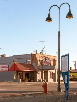
On East 4th Street at Toano Street, on the right when traveling east on East 4th Street.
On this site on July 4, 1910, Reno hosted "The Fight of the Century," a heavyweight championship boxing match between John Arthur "Jack" Johnson, the black title holder, and James J. "Jim" Jeffries, a former champion seeking to regain the title he . . . — — Map (db m94121) HM
On Bowers Mansion Road (Alternate U.S. 395) just north of Makayla Way, on the right when traveling north.
Mill erected in 1861 for the reduction of the ore from famed Comstock Ophir Mine. The Ophir Mill ceased to operate in 1866. Here a thriving town grew, second only in size to Washoe City, which at that time was the largest town in Washoe County. . . . — — Map (db m163884) HM
“Myriads of Stars shine over the graves of our ancestors.” Dat-So-La-Lee had seen some 96 winters, mostly in Carson Valley, when death came in 1925.
She was the last of those Washoe weavers whose ancient art had been practiced by countless . . . — — Map (db m20801) HM
On Flint Street at Court Street, on the left when traveling north on Flint Street.
Washington J. Marsh built this house in 1877. Myron C. Lake, regarded as a founder of Reno, purchased it in 1879, and ownership passed to his divorced wife, Jan, in 1881. This Italianate-style house has been moved twice and is listed in the National . . . — — Map (db m94123) HM
On West Moana Lane, on the right when traveling east.
Opened as a resort on October 29, 1905, Moana Springs took its name from a famous Hawaiian spa. In addition to a large bath house with a pool fed by hot springs, Moana had a stately hotel, a clubhouse, baseball diamond and picnic grounds. . . . — — Map (db m238880) HM
On Galetti Way at East 4th Street, on the right when traveling north on Galetti Way.
Opened to the public on June 20 1909, Coney Island was among the most elaborate amusement parks of its day. Otto G. Benschuetz, founder and owner, landscaped the grounds, put in a children's playground, a bandstand for outdoor concerts and a dance . . . — — Map (db m149980) HM
The Galena Creek Fish Hatchery represents an attempt to make amends after Nevada's Comstock Lode ravaged the region's ecosystem in the 1860s and 70s. Fishing decimated local streams and lakes to feed a growing population. Eventually, restocking . . . — — Map (db m94432) HM
Near Donner Pass Road, on the right when traveling east.
The rocks here are carved with ancient symbols called petroglyphs.
They were created by pecking the surface of the rock with a tool called a hammerstone. These petroglyphs are thought to be several thousand years old. — — Map (db m81931) HM
The Placer County Emigrant Road, known today as the Western States Trail, extended from Yankee Jim's on the Foresthill Divide to the Washoe Valley in Nevada. Built in 1852, the road served emigrants before providing a link to the Comstock boom towns . . . — — Map (db m143761) HM
On Alternate U.S. 95 1 mile north of Sierra Way, on the left when traveling south.
Wabuska (the Washoe Indian term for White Grass) was first established in the early 1870's as a station on the stage and freight road from Wadsworth on the Central Pacific to the roaring mining camps of Aurora, Bodie, Candelaria, Columbia and . . . — — Map (db m27643) HM
Near Bowers Mansion Road (Alternate U.S. 395) 5.8 miles north of Eastlake Boulevard, on the left when traveling north.
Gold Turns to Rust The Mansion Turns to Shambles AFTER EILLEY LOST THE MANSION IN 1876, the grand house passed through a number of different hands. Myron C. Lake first acquired the mansion and worked hard to revive its glory. The . . . — — Map (db m163627) HM
For thousands of years, people have crossed the Sierra Nevada near this place called Donner Pass.
Traveling by foot, wagon, train or automobile, the journey has always been challenging.
By Foot
Long before it’s “discovery” by . . . — — Map (db m23571) HM
On Mill Street at P Street, on the right when traveling east on Mill Street.
The earliest known breweries in Virginia City were the Nevada Brewery and the Virginia Brewery both founded between 1860 and 1861. The Nevada Brewery House on this site was not only the first, but the last to cease operations, closing its doors . . . — — Map (db m313840) HM
On Tahoe Boulevard (Nevada Route 28) 0.2 miles north of Ponderosa Ranch Road, on the right when traveling north.
Located on the mountain above are the remnants of the "Great Incline of the Sierra Nevada." Completed in 1880, this 4,000 foot long lift was constructed by the Sierra Nevada Wood and Lumber Company. A unique steam-powered cable railway carried . . . — — Map (db m94306) HM
Near Bowers Mansion Road (Alternate U.S. 395) 5.8 miles north of Eastlake Boulevard, on the left when traveling north.
IN ITS HEYDAY, Bowers Mansion was one of the most extravagant houses in the Nevada Territory, a product of mining wealth and personal taste. The story of Eilley and Sandy Bowers is a historic boom and bust tale. The mansion itself remains a . . . — — Map (db m163622) HM
Near Henness Pass Road (County Route S450) 1 mile east of California Highway 89 when traveling north.
There are three interpretive sites here at Kyburz Flat. Take a moment to understand the people who lived here, how each used the environment in different ways, and the unique marks each left on the landscape.
Visiting all three sites should take . . . — — Map (db m66039) HM
Site of the Historic
Maynard Block
Here was the Heart
of the City
A large building housed the
post office & stock exchange
dry goods & drug stores meat & grocery markets French modiste hair dresser barber shop & doctors . . . — — Map (db m46074) HM
This land was first home to the Washoe people. In 1850, the United States Congress created the Utah Territory, which then included present-day Nevada. In that year, Benjamin Green, John Musser, Abe Curry and Frank Proctor arrived in Carson County to . . . — — Map (db m298507) HM
On Main Street at Genoa Lane ( Route 206), on the right when traveling north on Main Street.
Panel One:
Utah Territory
The area now making up the state of Nevada was acquired by the United States after the Mexican-American War. This newly acquired land was generally labeled as unorganized territory until 1850. The State of . . . — — Map (db m227650) HM
First located in 1859, the Chollar was consolidated with the Potosi in 1865. As the Chollar-Potosi, it was one of the leading producers on the Comstock. The Nevada Mill was erected here in 1887 to process low-grade Chollar ore. It was the last to . . . — — Map (db m50109) HM
Near Bowers Mansion Road (Alternate U.S. 395) 5.8 miles north of Eastlake Boulevard, on the left when traveling north.
Dedicated in honor of the sons and daughters of Nevada, veterans of World War II. Erected by Sandy Bowers and his wife, Eilley Orrum, in 1864 with the gold and silver from their mine on the Comstock. Purchased in 1946 by popular subscription and . . . — — Map (db m163609) WM
On South Virginia Street (Nevada Route 430), on the right when traveling north.
Frederick Joseph DeLongechamps was Nevada’s foremost architect of his time. Statewide he was prolific in the number of buildings he designed. From this point one can see a group of structures that stand, collectively, as a monument to . . . — — Map (db m44217) HM
Near Jacks Valley Road/Main Street (Nevada Route 206) at Genoa Lane.
In 1851 Col. John Reese, with a little band of eighteen men crossed the great deserts and built the first trading post in Nevada, “Mormon Station”. Later came more members of the Mormon Faith who settled and established the town of Genoa. Among . . . — — Map (db m20686) HM
On North Virginia Street (Business U.S. 395) just south of East 2nd Street, on the left when traveling north.
The Nevada Equal Franchise Society founded in 1911 moved to the
Washoe County Bank Building at this location in 1913. This office sent suffrage news to papers across the state, set up national figures for speaking tours, and recruited workers from . . . — — Map (db m238881) HM
On Henness Pass Road, on the left when traveling west.
You are standing at a crossroads of human history that goes back to the time of the mammoth hunters. This passage over the Sierra Nevada was a key route for Native Americans, mountain men, wagon-train pioneers, miners, stage coaches and travelers . . . — — Map (db m94301) HM
On Carson Pass Highway (California Route 88 at milepost 6.4) east of Red Vista Road, on the right when traveling east.
[The first paragraph of the marker is unreadable]
One of the most popular passes through the Sierras along the Emigrant Trail was Carson Pass. This Pass was discovered by Kit Carson, a guide to the Fremont Party.
The Fremont Party, led by John . . . — — Map (db m223952) HM
On Lincoln Highway (U.S. 50 at milepost 13) west of Kings Canyon Road, on the right when traveling west.
This beautiful trail, with spectacular views of Lake Tahoe's high country, follows the route of an old flume and tunnel system that carried water from Marlette Lake to Virginia City. Originally built in 1877, the tunnel eventually collapsed and the . . . — — Map (db m229309) HM
On South Virginia Street (Nevada Route 430), on the right when traveling north.
In 1895, Washoe County District Attorney, Frank H. Norcross, later a Chief Justice of the Nevada Supreme Court and a Federal Judge, began a drive to establish Nevada’s first free public library in Reno. That year, he persuaded the Nevada Legislature . . . — — Map (db m44215) HM
On C Street (Nevada Route 341), on the right when traveling north.
[Located in the center of town is a monument on which there is mounted six markers commemorating historical events and people of Virginia City]West Side - Front of Monument:
In June of 1859 in Gold Canyon, a second group of . . . — — Map (db m21565) HM
On Main Street at Sacramento Street, on the right when traveling east on Main Street.
A Viking Son of Norway who fulfilled California’s motto:
“Bring Me Men To Match My Mountains”
For twenty winters from 1858 to 1878 he was the lifeline between Utah Territory across the Sierras, and the new state of California. . . . — — Map (db m12750) HM
On Wildwood Avenue, on the right when traveling west.
This statue represents and honors the Washoe Tribe of Nevada and California. As the original inhabitants of Lake Tahoe, the Washoe people's life cycles revolved around Lake Tahoe. For thousands of years the Washoe People have been the caretakers . . . — — Map (db m258674) HM
On South Virginia Street at East Peckham Lane, on the right when traveling north on South Virginia Street.
Here was located one of the busiest crossroads of pioneer Nevada, converging point for many major toll roads of the area. The earliest emigrants from the east crossed through Truckee Meadows at this point and by 1853 the intersection was known as . . . — — Map (db m93674) HM
Flowing out of the Sierra Nevada Mountains to the west, the Truckee River is Reno’s most striking natural and historical feature. Shown below on a relief map of the surrounding Reno area are a few of the more significant historical sites near the . . . — — Map (db m44212) HM
Near Interstate 80 at milepost 27, on the right when traveling east.
The Truckee River, seen below, runs from Lake Tahoe to Pyramid Lake. The river's first recorded discovery was by Captain John C. Fremont in January, 1844. He camped by its terminus at Pyramid, then followed it to the big bend at Wadsworth. Captain . . . — — Map (db m67268) HM
"During the early days of statehood Washoe City shone as a bright star in the new firmament.”
Washoe City-Founded 1861-County Seat of Washoe County, Nevada territory. Timber supplier to the Comstock Lode. Home to 10 quartz mills and 281 stamps. . . . — — Map (db m131827) HM
The Applegate-Lassen Trail is a 130 mile stretch of the greater Applegate and Lassen trails which run through Pershing, Humboldt, and Washoe Counties. This section parts from the California Trail at the Humboldt River and Northern end of Rye . . . — — Map (db m244726) HM
On Fremont Highway (Oregon Route 31) south of Thousand Springs Lane (County Route 4-17), on the right when traveling north.
side 1
The reports of this expedition directed the migration of the western settlement toward the Oregon Country which hitherto had been merely a rendezvous for trappers.
On December 16th 1843 the expedition, while enroute . . . — — Map (db m113809) HM
On W Lake Blvd, on the right when traveling north.
Trails become roads around Lake Tahoe
Early travel in the Lake Tahoe basin was along Washoe Indian trails and later along American immigrant trails blazed in the 1840s over the rugged Sierra Nevada Mountain passes. The first roads in the . . . — — Map (db m112967) HM
On Alleghany Ridge Road at Highway 49, on the right when traveling north on Alleghany Ridge Road.
In 1859 the rich Comstock Silver Lode was discovered in Washoe Territory, Nevada, causing many miners to quickly pack up and head east. Immediately a company was formed to construct a road connecting this area of California to the Comstock finds. . . . — — Map (db m65968) HM
On South B Street north of Taylor Street, on the right when traveling south.
Following the discovery of silver and gold, the miners obtained their water from the small streams or from the springs located in the canyons such as Ophir Ravine, in Virginis City, and Bullion and Crown Point ravines above Gold Hill. Originally . . . — — Map (db m263686) HM
Near West Lake Boulevard (State Highway 89) west of State Highway 26.
Business and tourists
Outlet point is the location where the waters of Lake Tahoe find their only release from the lake basin along the Lower Truckee River at Tahoe City
The sheltered inlet of the Truckee River mouth provided safe harbor . . . — — Map (db m34932) HM
On North Plaza Street at East Washington Street on North Plaza Street.
For hundreds of years prior to the
White Man the Washoe and Paiute
Indians used this site as a recreation area and played a type of
ball game here. Later, in the year
1872, the area became the freight
vards of the historic Virginia &
Truckee . . . — — Map (db m136166) HM
On Pike Street south of Tyler Street, on the right when traveling south.
The Misfits is a contemporary western drama filmed in 1960 and is best known for the final film roles of movie legends Clark Gable and Marilyn Monroe. It was directed by John Huston and written by playwright Arthur Miller. In 1956, Miller . . . — — Map (db m201467) HM
On Comstock Mining Road 0.2 miles east of Cemetery Road, on the right when traveling east.
Gold and silver were discovered in 1907, 4 miles west along the Ophir Grade to Washoe Valley.
Selby Mining Co. built the first mill, followed by the Jumbo Saloon, Mineral Barber Shop, Hotel Jumbo, and until 1910 a U.S. Post Office. The Jumbo . . . — — Map (db m238352) HM
On County Route 395, on the right when traveling south.
The cemetery's first known burials were in 1861, the year Nevada became a Territory and Washoe City became the Washoe County seat. Wood and water to work the Comstock ores were the vital resources that made Washoe City an industrial community. . . . — — Map (db m307341) HM
Near Emerald Bay Road (California Route 89) west of Cascade Road, on the right when traveling west.
From the vista, you can observe Emerald Bay and learn about its rich and colorful past
Residents & Visitors
For thousands of years, Lake Tahoe's Emerald Bay has drawn people to its shores. The Washoe Indians made their . . . — — Map (db m275495) HM
On Lakeshore Boulevard south of Stateline AVenue, on the left when traveling north.
Lakeside Park was once the Washoe Indians' favorite location for their "love feasts' or fandangos.
In 1860 a Fish Market and Landing was located where Lakeside Marina is today. The fish were used at Lapham's Stateline Hotel, and most likely sold . . . — — Map (db m227672) HM
Claimed on July 4, 1859 by R. Crale, C. Chase, H. Carmack, W. Surtevant, A.O. Savage and L.C. Savage, the original Savage claim consisted of 1,800 feet along the Comstock Lode. In 1865, the company built a mill in Washoe Valley to process ore. . . . — — Map (db m22437) HM
On Rancho Drive, on the left when traveling north.
Rancho Haven was originally part of the Red Rock Ranch, a family-owned cattle grazing operation that covered tens of thousands of acres of private and public lands marked by abundant springs.
Danish emigrant Sophus Petersen was in the US by . . . — — Map (db m286416) HM
These are the first Lincoln Highway bridge rails ever built on the nation's first transcontinental highway. The Abraham Lincoln Highway ran from Times Square, New York, to Lincoln Park in San Francisco, during 1913-1927.
Towns all across the . . . — — Map (db m67269) HM
On 537 South "C" Street, on the right when traveling north.
From the first recorded ore discoveries in 1859, the Comstock area was part of a global community. Arriving from places as diverse as the Germanies, Poland, Russia, and North America, Jewish immigrants with engineering backgrounds, . . . — — Map (db m40485) HM
On Washington Street at R Street on Washington Street.
[Panel 1]:
Comstock Trail
You will find the trail head sign a hundred yards ahead, next to the recycling/dump site. Beyond the dump site is a ridge extending to your left. The trail winds along this ridge for two miles through . . . — — Map (db m46131) HM
On Donner Pass Road, on the left when traveling east.
History
The Washoe Tribe lived on the eastern face of the Sierra Nevada mountains for more than 6,000 years. They didn’t actually call themselves the Washoe Tribe, though. They called themselves the Waashiw (Wa-she-shu) tribe, meaning . . . — — Map (db m81899) HM
Near Emerald Bay Road (State Highway 89), on the right when traveling west.
A Sacred Gathering Place
Many generations of Washoe people spent summers here, living near the shores of Lake Tahoe. Known as da ow a ga by the Washoe, the lake provided a sacred meeting place, where summer gatherings were a focus of . . . — — Map (db m275491) HM
The only quartz stamp mill in which Adolph Sutro was
directly involved was built in 1861 on the Carson River near
Dayton, Nevada. After examining Comstock ores, Sutro
believed he could recover their values more efficiently than
existing . . . — — Map (db m300298) HM
Thin black lines indicate changes in relevance. Between each pair of lines entries are ordered geographically but all have the same relevance.
* Inflectional forms of words are their plurals, singulars, and possessives as well as gramatical tenses and similar variations.