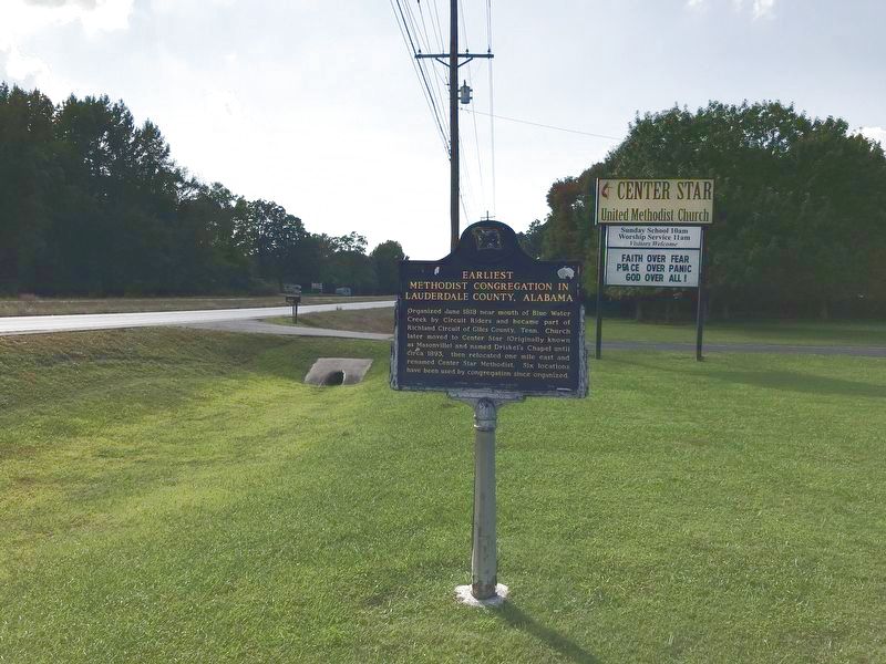
On Lee Highway (U.S. 72) 0.2 miles west of County Road 69, on the right when traveling west.
Organized June 1818 near mouth of Blue Water Creek by Circuit Riders and became part of
Richland Circuit of Giles County, Tenn. Church later moved to Center Star (Originally known as Masonville) and named Driskel's Chapel until círca 1893, then . . . — — Map (db m156911) HM
Near Hightower Place south of Veterans Drive (Alabama Route 133), on the left when traveling south.
In his 14 years in the U.S. House of Representatives (1977-1991), Ronnie Flippo held such important posts as the chairmanship of the Space Science Subcommittee during the development of the space shuttle, Columbia. — — Map (db m219170) HM
In the early 1800's Cherokees of this area were under the leadership of Doublehead and Tahlonteskee. After Doublehead's assassination in 1807, Tahlonteskee notified President Jefferson that he and his people were ready to move west. In 1808 . . . — — Map (db m36030) HM
Nature Preserve and Recreation Area
This tract was protected through the efforts of the Alabama's Forever Wild Land Trust,
The Alabama Lands of The Department of Conservation and Natural Resources with assistance of the Lauderdale County . . . — — Map (db m106468) HM
On Lee Highway (U.S. 72) at Big Oak (County Route 107), on the right when traveling east on Lee Highway.
(side 1)
Center Star was spelled Centre Star into the 1900s. The name evolved from the US Postal Service, which served remote areas by "star routes." The Post Office here, which existed from 1850 to 1914 (except between 1902 and 1913), . . . — — Map (db m264510) HM
On West Tennessee Street at South Court Street, on the right when traveling east on West Tennessee Street.
Lauderdale County was created by the Territorial Legislature in February 1818. On March 12, 1818, recognized as the Founding Day for Florence, Alabama the Articles of Association was signed by the seven trustees of the newly-organized Cypress . . . — — Map (db m115156) HM
On West Alabama Street at South Court Street, on the right when traveling west on West Alabama Street.
A County Older Than the State
Lauderdale County
created Feb. 6, 1818
by Alabama Territorial Legislature (Alabama became a state in 1819).
Named for Col. James Lauderdale, cavalryman under Gen. John Coffee and Andrew Jackson, War of . . . — — Map (db m35185) HM
On S. Court Street at Dr Hicks Blvd. on S. Court Street.
The American Legion, an organization of U.S. War Veterans was founded in Paris, France, March 15~17, 1919 by delegates from combat and service units of the American Expeditionary Force assembled in response to a call by a committee headed by . . . — — Map (db m35220) HM
On Lee Highway (County Route 72) at Houstontown raod (Route 33), on the right when traveling east on Lee Highway.
Jesse James Gang
Canal Payroll Robbery
March 1881
In, 1881, approximately three miles south of here, the U.S. Corps of Engineers was constructing the Muscle Shoals Canal along the north side of the Tennessee River. On March 11, 1881, . . . — — Map (db m99897) HM
On Veterans Park Drive at South Cox Creek Parkway (Alabama Route 133), on the left when traveling south on Veterans Park Drive.
In the late 1960s, Point Park was developed by the City of Florence on this 82-acre site, leased from TVA, for outdoor recreation. It was the first multi-use sport complex in the State of Alabama. In the early 1970s, plans were developed for a . . . — — Map (db m74407) HM
On East Tennessee Street (U.S. 72) at Short Court Street, on the left when traveling west on East Tennessee Street.
Prior to the repeal of the Militia Act in 1902, states maintained their own militia. One of the last militia in Florence and Lauderdale County was the Wheeler Rifles.
Organized in 1888, under the command of Captain Julian Fields, it was named for . . . — — Map (db m32774) HM
On Wheeler Dam Highway (Alabama Route 101) 0.5 miles south of County Route 584, on the left when traveling south.
Wheeler Dam
Wheeler Dam is located south of here on the Tennessee River, between Lauderdale County on the north and Lawrence County on the south. It is located 275 miles above the mouth of the Tennessee River at Paducah, Ky. on the Ohio River. . . . — — Map (db m105132) HM
On East Limestone Street at Carroll Ave N, on the right when traveling west on East Limestone Street.
The Alabama Territorial Legislature created Franklin County on
February 6, 1818, from lands ceded two years earlier by the
Chickasaw and Cherokee nations. The county was named in honor
of Benjamin Franklin. The first sheriff was James Frazier. . . . — — Map (db m285558) HM
Near Hightower Place south of Veterans Drive ( Route 133), on the left when traveling south.
In 1891, G.W. Goethals, in his role as supervisor of public works on the Tennessee River, reported directly to the Secretary of War. Later, he was Chief Engineer for the construction of the Panama Canal. — — Map (db m219307) HM
On North Wood Avenue at E Tombigbee Street, on the right when traveling north on North Wood Avenue.
The sculpture relief located above the Library's front entrance on North Wood Avenue was created by James Abbott Stoves (1868-1948). Stoves was a stone carver and proprietor of Florence Marble Works. The sculpture was originally placed above the . . . — — Map (db m304195) HM
On Lauderdale County 14, on the right when traveling west.
One of Alabama's oldest incorporated towns. Waterloo was an important Tennessee river port during the steamboat era. In low~water season after large boats from Louisville, Cincinnati and other places downriver unloaded here: smaller craft . . . — — Map (db m84302) HM
On Main Avenue at 1st Street, on the right when traveling south on Main Avenue.
Byler Road
Pioneer's settled path to new lands, agriculture, transport and commerce that began in Northwest Alabama.
140 mile corridor/route designated on December 19th, 1819 by the State Legislature. This was Alabama's first . . . — — Map (db m308392) HM
On Main Street at King Street (Old Route 20), on the right when traveling north on Main Street.
FrontByler Road
Pioneer's settled path to new lands, agriculture, transport and commerce that began in Northwest Alabama.
140 mile corridor/route designated on December 19th, 1819 by the State Legislature. This was . . . — — Map (db m205287) HM
On County Line Road (County Road 99) at County Road 343, on the right when traveling north on County Line Road.
Beginning in Lauderdale County where it connected to Jackson's Old Military Road, Byler's Turnpike ran to Tuscaloosa. Only days after Alabama's statehood 14 Dec 1819, this first state road was approved by the legislature. Laid out along portions of . . . — — Map (db m153263) HM
On Kendall Road (County Road 7) east of Stony Point Road (County Road 24), on the right when traveling west.
The clock was discarded when the Lauderdale County Courthouse was torn down in 1963, and was taken to Belgreen, Alabama, 45 miles South of Florence.
The clock rested and rusted under an oak tree until 1986, when it was found by Douglas Farley. . . . — — Map (db m297166) HM
On County Road 568 at County Road 51, on the left when traveling west on County Road 568.
The home-place of Bettie Anne Springer-Thornton lies 1.6 miles north on the east side of Lauderdale County Road 51. This home was originally a one-room log cabin, built between 1892 and 1894 by Levi Patrick Thornton. Two rooms and a dog-trot were . . . — — Map (db m141966) HM
On Lovers Lane (County Route 610) west of Lambs Ferry Road, on the right when traveling east.
East End High School was the first school for African-American students in eastern Lauderdale County. Several elementary schools for Africian-American children were established in the area, including the Rogersville School located on the north . . . — — Map (db m215931) HM
On J.C. Mauldin Highway west of Poplar Street, on the right when traveling west.
[Side 1:] The area known as Killen in Lauderdale County, was settled in the early 1800s. In 1826, Joseph Mason was appointed the first postmaster of the new community called Masonville, later to become Killen. The post office existed . . . — — Map (db m35169) HM
On College Street at Williams Street, on the left when traveling east on College Street.
(side 1)
Prior to 1912, a private school, Rogersville High School, was housed in a two-story wooden frame building located in this vicinity. On August 7, 1907, an act was passed by the Alabama Legislature to establish a state high school in . . . — — Map (db m84297) HM
On Alabama Route 207 south of Hammond Street, on the right when traveling south.
(side 1)
Early settlers in Anderson date back to 1818 when James Anderson settled approximately a mile south of here. The earliest permanent settlement was located about one mile north of here on Anderson Creek around 1825 and was known . . . — — Map (db m133189) HM
On Alabama Route 101 at Mill Creek Cir, on the right when traveling north on Alabama Route 101.
In 1816, the Chickasaws ceded land north of the Tennessee River to the
government and, in 1817, the Cherokees ceded Doublehead's Reserve.
These land acquisitions opened the area around modern-day Lexington
to early settlers. Lauderdale County . . . — — Map (db m309429) HM
On Point Mallard Circle, on the left when traveling east.
Doublehead (c. 1744-1807) was a very influential Cherokee leader in the Decatur area and controlled this country with an iron fist. He lived for a long time at the old Browns Ferry crossing just west of Decatur.
He and his last wife Katelia . . . — — Map (db m280656) HM
Thin black lines indicate changes in relevance. Between each pair of lines entries are ordered geographically but all have the same relevance.
* Inflectional forms of words are their plurals, singulars, and possessives as well as gramatical tenses and similar variations.