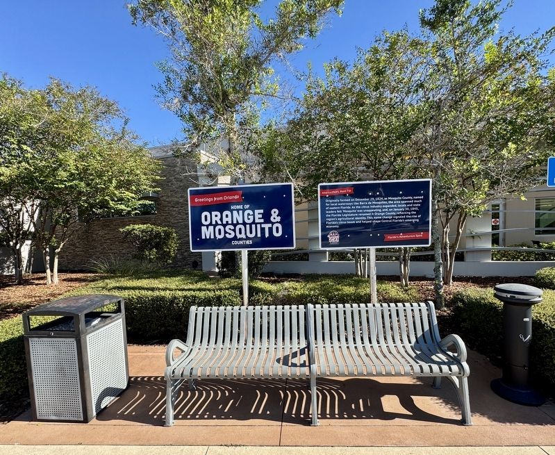
By Brandon D Cross, October 30, 2025
Orange and Mosquito Counties Marker
RANKED BY RELEVANCE
| Near Florida's Turnpike (at milepost 263), 2 miles south of Spessard L Holland Expressway (Florida Route 408), in the median. |
| Near Jay Blanchard Trail 0.5 miles west of Rouse Road, on the right when traveling west. |
| On W Central Boulevard 0.1 miles N. Court Street, on the left. |
| On U.S. 41 1.1 miles north of Oak Street (Northwest 9th Street), on the left when traveling north. |
| On Wekiva River Road 0.1 miles south of Chipola Trail, on the left when traveling south. |
| On South Binion Road (State Road 437) 0.8 miles west of Ocoee-Apopka Road (County Road 437A), on the right when traveling south. |
| Near Summerlin Avenue at Gatlin Avenue, on the right when traveling north. |
| On Gatlin Avenue at South Summerlin Avenue, on the left when traveling east on Gatlin Avenue. |
| On Brick Road at Tildenville School Road, on the right when traveling west on Brick Road. |
| Near Lake Lily Drive (now a footpath). |
| Near Harrell Road 0.4 miles north of East Colonial Drive (Florida Route 50), on the left when traveling north. |
| Near East Colonial Drive (Florida Route 50) west of Central Park Avenue, on the right when traveling west. |
| Near Babb Road 0.2 miles north of Princess Lane, on the right when traveling north. |
| On North Central Avenue (State Road 419/434) at Railroad Street, on the left when traveling north on North Central Avenue. |
| On Edgewater Drive just east of Rose Avenue, on the right when traveling north. |
| On Wekiva River Road 0.1 miles south of Chipola Trail, on the left when traveling south. |
| Near Gatlin Avenue at Kennedy Avenue. |
| On Alamo Drive at 29th Street, on the left when traveling south on Alamo Drive. Reported missing. |
| On Rouse Road south of Riverbank Boulevard, on the right when traveling south. |
| On Bentley Street at North Westmoreland Drive, on the right when traveling west on Bentley Street. |
| On East Central Boulevard at Court Avenue, on the right when traveling west on East Central Boulevard. |
| Near Greenwood Street 0.3 miles east of South Mills Avenue when traveling east. |
| On West 7th Avenue west of Main Street, on the right when traveling west. |
| On Babb Road 0.2 miles north of Princess Lane. |
| Near Bush Boulevard west of South Orlando Drive (U.S. 17/92), on the left when traveling west. |
| Near Babb Road 0.2 miles north of Princess Lane. |
| Near Babb Road 0.2 miles north of Princess Lane. |
| On Main Street north of 3rd Street, on the right when traveling north. |
| On South Conway Road (State Road 15) just south of Lake Margaret Drive, on the right when traveling south. |
| On East Kennedy Boulevard at North College Avenue, on the right when traveling east on East Kennedy Boulevard. |
| On West Princeton Street 0.1 miles east of North Westmoreland Drive, on the right when traveling north. |
| On Wilma Street south of West Church Avenue, on the right when traveling north. |
| Near New York State Route 17A 0.4 miles Gibson Rd (County Route 100), on the right when traveling south. |
| On Baptist Camp Road north of East Kelly Park Road, on the right when traveling north. |
| Near North Fort Christmas Road (County Route 420) 0.1 miles north of Christmas Cemetery Road, on the left when traveling north. |
| Near Freedom Avenue 0.3 miles south of Parker Street, on the right when traveling south. |
| Near Old Vineland Road at Princess Way, on the right when traveling south. |
| On Courtenay Parkway North (State Road 3) 0.3 miles north of Biolab Road, on the left when traveling north. |
| On South Conway Road at Merryweather Drive, on the right when traveling south on South Conway Road. |
| On North Lakeshore Drive at Oakland Avenue, on the right when traveling south on North Lakeshore Drive. |
| Near North Forest Avenue at Corrine Drive, on the left when traveling north. |
| On West South Street west of South Division Avenue, on the right when traveling west. |
| On East Seminole Boulevard west of North Mellonville Avenue, on the left when traveling east. |
| Near State Highway 86, on the right when traveling south. |
| On South Bronough Street 0.1 miles south of West Pensacola Avenue, on the right when traveling south. |
| On Randolph Avenue 0.1 miles north of Hoffner Avenue, on the left when traveling north. |
| Near Babb Road 0.2 miles north of Princess Lane, on the right when traveling north. Reported permanently removed. |
| Near West 7th Street just west of Myrtle Avenue, on the right when traveling west. |
| On State Highway 28 at Old Charleston Road (Local Road 38), on the left when traveling south on State Highway 28. |
| On La Palma Avenue 0.2 miles east of Kraemer Boulevard, on the left when traveling east. |
| Near North State College Boulevard. |
| On North Parramore Avenue at West Jefferson Street, on the right when traveling north on North Parramore Avenue. |
| Near Central Boulevard 0.1 miles north of Court Street. |
Thin black lines indicate changes in relevance. Between each pair of lines entries are ordered geographically but all have the same relevance.* Inflectional forms of words are their plurals, singulars, and possessives as well as gramatical tenses and similar variations.
Nov. 19, 2026

