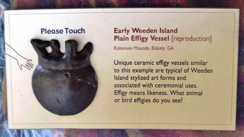
Marker detail: Early Weeden Island Plain Effigy Vessel
RANKED BY RELEVANCE
Near Sunray Road 0.6 miles south of Mahan Drive (U.S. 90), on the right when traveling south.
Near Old Sugar Mill Road east of Herbert Street, on the left when traveling east.
On Old Sugar Mill Road east of Herbert Street, on the left when traveling east.
Near Sunrise Boulevard at Mansion Boulevard, on the left when traveling east.
Near Old Sugar Mill Road east of Herbert Street, on the left when traveling east.
Near Old Sugar Mill Road east of Herbert Street, on the left when traveling east.
Near Old Sugar Mill Road east of Herbert Street, on the left when traveling east.
Near Old Sugar Mill Road east of Herbert Street, on the left when traveling east.
Near Old Sugar Mill Road east of Herbert Street, on the left when traveling east.
On John Anderson Drive north of Granada Boulevard (State Road 40), on the left when traveling north.
On Old Sugar Mill Road east of Herbert Street, on the right when traveling east.
Near Old Sugar Mill Road east of Herbert Street, on the left when traveling east.
On Old Sugar Mill Road east of Herbert Street, on the left when traveling east.
On South Atlantic Avenue (County Road A1A) 0.1 miles south of Kingfish Avenue, on the right when traveling south.
On Silver Beach Avenue 0.2 miles east of City Island Parkway, on the right when traveling east.
Paid Advertisement
On Silver Beach Avenue 0.3 miles east of City Island Parkway, on the right when traveling west.
On Silver Beach Avenue 0.1 miles west of South Peninsula Drive, on the right when traveling west.
On Silver Beach Avenue 0.1 miles east of City Island Parkway, on the right when traveling west.
On Silver Beach Avenue 0.2 miles east of City Island Parkway, on the right when traveling west.
On Silver Beach Avenue 0.2 miles City Island Parkway, on the right when traveling west.
On Silver Beach Avenue 0.3 miles east of City Island Parkway, on the right when traveling west.
On Orange Avenue 0.3 miles east of City Island Parkway, on the right when traveling east.
On Silver Beach Avenue 0.3 miles east of City Island Parkway, on the right when traveling west.
On Silver Beach Avenue 0.2 miles west of South Peninsula Drive, on the right when traveling west.
On Silver Beach Avenue 0.3 miles west of South Peninsula Drive, on the right when traveling west.
On Silver Beach Avenue 0.2 miles west of South Peninsula Drive, on the right when traveling east.
On Silver Beach Avenue 0.2 miles west of South Peninsula Drive, on the right when traveling east.
On Silver Beach Avenue 0.1 miles west of South Peninsula Drive, on the right when traveling west.
On Northeast 1st Street at North Swinton Avenue, on the right when traveling west on Northeast 1st Street.
Near South Peninsula Drive 0.1 miles south of south of Ocean Way Drive.
Near Green Springs Road at Enterprise Osteen Road, on the right when traveling north.
Paid Advertisement
On Enterprise Osteen Road at Green Springs Road, on the left when traveling east on Enterprise Osteen Road.
Near Enterprise Osteen Road at Green Springs Road, on the left when traveling east.
Near Enterprise Osteen Road at Green Springs Road, on the left when traveling east.
Near Green Springs Road at Enterprise Osteen Road, on the right when traveling north.
On Enterprise Osteen Road at Green Springs Road, on the left when traveling east on Enterprise Osteen Road.
On Rockefeller Drive at South Atlantic Avenue (Florida Route A1A), on the right when traveling west on Rockefeller Drive.
On South French Avenue (U.S. 17/92) north of West 18th Street, on the right when traveling south.
Near Ponce Deleon Boulevard at County Road 3N.
On South Ridgewood Avenue (U.S. 1) north of West Ocean Avenue, on the right when traveling north.
On North Woodland Boulevard (U.S. 17/92) north of Rich Avenue, on the left when traveling north.
On East Dundee Avenue at East Retta Street, on the right when traveling north on East Dundee Avenue.
On South Central Avenue (State Road 19) at Golden Gem Drive, on the right when traveling north on South Central Avenue.
On West Seminole Boulevard (U.S. 17/92) north of Interstate 4.
On North Woodland Boulevard (U.S. 17/92) 0.1 miles north of New York Avenue (Florida Route 44), on the right when traveling north.
On North Woodland Boulevard (U.S. 17) at New York Avenue (Florida Route 44), on the right when traveling south on North Woodland Boulevard.
Near South Atlantic Avenue east of South Peninsula Drive.
Paid Advertisement
On West International Speedway Boulevard (U.S. 92) at Bill France Boulevard , on the right when traveling east on West International Speedway Boulevard.
On Florida Route 415 at New Smyrna Boulevard, on the right when traveling north on Florida Route 415.
On George W Engram Boulevard at Walker Avenue, on the right when traveling east on George W Engram Boulevard.
On Jacob Brock Avenue at Clark Street, on the left when traveling east on Jacob Brock Avenue.
Near East Blue Springs Avenue west of South Thorpe Avenue, on the right when traveling east.
On South Atlantic Avenue 0.1 miles south of Kingfish Avenue, on the right when traveling south.
On West Rhode Island Avenue at South Sparkman Avenue, on the right when traveling west on West Rhode Island Avenue.
On West Indiana Avenue 0.1 miles west of Woodland Boulevard (U.S. 17/92), on the left when traveling west.
On West New York Ave (State Road 44) 0.1 miles west of Woodland Boulevard (U.S. 17/92), on the right when traveling west.
Near Ponce Deleon Boulevard at South County Road 3.
On Main Street north of 3rd Street, on the right when traveling north.
Near Lightfoot Lane south of County Road 3, on the right when traveling south.
Near Lightfoot Lane south of County Road 3, on the right when traveling south.
Near Lightfoot Lane south of County Road 3, on the right when traveling south.
Near Lightfoot Lane south of County Road 3, on the right when traveling south.
On Lightfoot Lane south of County Road 3, on the right when traveling south.
Paid Advertisement
Near Lightfoot Lane south of 3, on the right when traveling south.
Near Lightfoot Lane west of County Road 3, on the right when traveling south.
Near Lightfoot Lane south of County Road 3, on the right when traveling south.
Near Ponce Deleon Boulevard at South County Road 3.
Near Magnolia Avenue (Becker Boulevard) 1 mile south of West French Avenue.
On Osteen Cemetery Road 0.6 miles north of Trade Street, on the right when traveling north.
Near Lightfoot Lane south of County Road 3, on the right when traveling south.
Near Kalua Way just north of Alhambra Avenue, on the right when traveling north.
On South Bronough Street 0.1 miles West Pensacola Avenue, on the right when traveling south.
On West Indiana Avenue west of North Woodland Boulevard (U.S. 17/92), on the left when traveling west.
︽
Thin black lines indicate changes in relevance. Between each pair of lines entries are ordered geographically but all have the same relevance. * Inflectional forms of words are their plurals, singulars, and possessives as well as gramatical tenses and similar variations.
Nov. 19, 2026