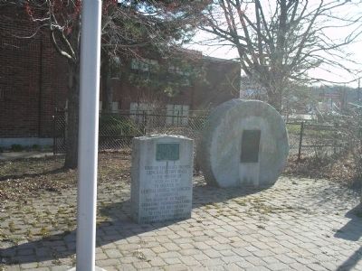
On Main Street (Massachusetts Route 20) at Weston Street (U.S. 20), on the right when traveling east on Main Street.
Through this place passed General Henry Knox in the winter of 1775 – 1776 to deliver to General George Washington at Cambridge the train of artillery from Fort Ticonderoga used to force the British Army to evacuate Boston. Erected by the . . . — — Map (db m18119) HM
On Moody Street at Main Street (U.S. 20), on the left when traveling south on Moody Street.
(north face)
Commissioned Major General of US Volunteers MDCCCLXI
Command of Fifth Corps, Army of the Potomac
Command of the Defences of Washington
Command of the Department of the Gulf
(south face)
Speaker Massachusetts . . . — — Map (db m179165) HM WM
On Main Street (U.S. 20) at Moody Street, on the right when traveling east on Main Street.
This mall dedicated in honor of the men and women of this community who served our country in all wars thus preserving our freedom and our way of life
Erected by the City of Waltham 1973 — — Map (db m179141) HM
Near Main Street (U.S. 20) at Moody Street, on the right when traveling east.
(northern face)
To the Nation's Defenders
Francis H. Priest • Nahum Rand • F.P.H. Rogers • James Roony • Horace Sanderson • Samuel G. Savage • Robert C. Sherman • Simeon Smith • William A. Smith • Thomas E. Stickney • George G. . . . — — Map (db m179177) WM
On South Street 0.1 miles north of Norumbega Road, on the left when traveling south.
On this site stood the Roberts Paper Mill, a prominent example of a thriving industry in Waltham in the nineteenth and early twentieth centuries.
One can see the prosperity that the mills generated by visiting Gore Place,
Main Street in . . . — — Map (db m222225) HM
On Main Street (U.S. 20) east of Massasoit Street, on the right when traveling east.
Grove Hill Cemetery is the resting place for the family gravesite of Congressman, Mass. Governor, and Civil War General Nathaniel P. Banks.
The Hiram and Gardner Banks Family gravesites are nearby. There are also more than 100 other Civil War . . . — — Map (db m244983) HM
Near Newton Street at St. Paul's Avenue, on the right when traveling west.
One of the most magnificent surviving carriage houses in New England, the Anderson Carriage House was designed by Edmund Wheelwright, former city architect of Boston, for the summer estate of William Fletcher Weld II. Its design was inspired by the . . . — — Map (db m33022) HM
Near Newton Street at St. Paul's Avenue, on the right when traveling west.
Putterham School
c. 1768
The only remaining eighteenth-century schoolhouse in Brookline, Putterham School was built to serve the farm families of South Brookline. Classes were held at this one-room schoolhouse for more than 150 years. Around . . . — — Map (db m33020) HM
On Harvard Street at Shailer Street, on the right when traveling north on Harvard Street.
Edward Devotion (1621-85) settled in Brookline around 1650, when it was a farming community known as Muddy River. Devotion's farm included apple orchards and pastureland for sheep and cattle. His son left a bequest to the town for public schooling: . . . — — Map (db m286809) HM
On Hancock Street at Washington Street, on the left when traveling south on Hancock Street.
“Improve your understanding for acquiring useful knowledge and virtue, such as will render you an ornament to society, an Honour to your Country, and a Blessing to Your parents.” Abigail Adams in a letter to her . . . — — Map (db m299843) HM
On Viden Road at Franklin Street, on the right when traveling north on Viden Road.
From this spot, with her son, John Quincy Adams, then a boy of seven, by her side, Abigail Adams watched the smoke of burning Charlestown, while listening to the guns of Bunker Hill. Saturday, 17 June, 1775.
The Adams . . . — — Map (db m299840) HM
On Adams Street at Hancock Street, on the right when traveling east on Adams Street.
has been designated a
National Historic Landmark
This building possesses national significance
in commemorating the history of the
United States of America — — Map (db m119010) HM
On Granite Street at Thomas E. Burgin Parkway, on the right when traveling south on Granite Street.
Erected by
The Burns Memorial Association
of Quincy Mass.
in honor of
Robert Burns
Scotland's most famous poet
and advocate of liberty
and democracy
"No Spartan tube, no Attic shell
No lyre Æolian I awake . . . — — Map (db m119033) HM
Near Hancock Street at Coddington Street, on the right when traveling south.
Built in 1828, this church is the fourth edifice to house the town's earliest congregation and is the resting place of two United States Presidents and First Ladies. The building was endowed by John Adams, who specified it be a "Temple of stone" . . . — — Map (db m234475) HM
On Sea Street north of Southern Artery ( Route 3A), on the left when traveling north.
In Honor Of
Our Patriot Soldiers.
Killed in Battle.
[Roll of Honored Dead]
Died of Wounds
Received in Battle.
[Roll of Honored Dead]
Died in Prison.
[Roll of Honored Dead]
Died of Disease
contracted in the Army . . . — — Map (db m119039) HM
Near Hancock Street at Coddington Street, on the right when traveling south.
Here was buried
Colonel John Quincy
of
Mount Wollaston
1689 - 1767
From whom Quincy was named
1792
The Quincy Historical Society places this Memorial
1904 — — Map (db m234478) HM
On Southern Artery (Massachusetts Route 3A) north of Greenleaf Street, on the right when traveling north.
The International
H. C. B. and C.
Laborer's Union
of America
to
D. D'Alessandro
[Bronze bas-relief panels]
Domenico D’Alessandro
International H. C. B. and C.
Laborer's Union of America [seal]
Labor omnia vincit ["Work conquers . . . — — Map (db m119230) HM
Near Magnolia Avenue west of Cypress Avenue, on the right when traveling west.
Erected by
John Veader
in memory of his daughter
Etta M. Hutchins
wife of Samuel G. Hutchins
Died Feb. 20, 1901
aged 34 yrs.
This grave given my beloved neice [sic]
by her Uncle Joseph Veader
Her last request was
"I want . . . — — Map (db m122535) HM
On Sea Street near Southern Artery ( Route 3A), on the left when traveling north.
Born Dec. 12, 1901
Enlisted March 30, 1917
Killed in Action when
U.S.S. Jacob Jones
was torpedoed at sea
Dec. 6, 1917
First Quincy Boy
killed in the World War — — Map (db m119043) WM
On Granite Rail Court 0.2 miles east of Oconnell Avenue, on the right when traveling east.
This gateway marks the foot of the old incline, a part of the Granite Railway.
The idea of this railway was conceived and carried out by Gridley Bryant, in the face of great opposition but supported by Thomas Handasyd Perkins, to transport the . . . — — Map (db m198169) HM
On Hancock Street, on the right when traveling south.
Set apart after 1640 • • • • • Here lie buried The early settlers of the town the first minister the first teacher Rev. John Hancock (1702 – 1744) for whom this place is named Father of the patriot Henry Adams (1583 – 1646) and . . . — — Map (db m31249) HM
On Hancock Street at Coddington Street, on the right when traveling south on Hancock Street.
Hancock Cemetery dates from the earliest days of European settlement. For many years this was the town's only burial ground, and remained the main burial ground until the 1850s. Generations of the Adams, Quincy, and other prominent American . . . — — Map (db m234479) HM
On Hancock Street, on the right when traveling south.
Here lyeth the body of Henry Adams founder of the Braintree branch of the Adams family in America buried in this cemetery Oct. 8, 1646 — — Map (db m31253) HM
Near Hancock Street at Coddington Street, on the right when traveling south.
James R. McIntyre, AB. M.A. J.D.
1930-1984
This Building Dedicated in his Honor
Quincy Native, Scholar, Officer of Marines, Korean War, Attorney, Statesman and Gentleman.
Served his city and state with honor and distinction as councillor, . . . — — Map (db m234476) HM
On Burgin Pkwy at Dimmock Street, on the right when traveling north on Burgin Pkwy.
Farmer Lawyer Patriot Diplomat First Vice President Second President of the United States Side of Monument: There is danger from all men. The only maxim of a free government ought to be to trust no man living with power to endanger the public . . . — — Map (db m18052) HM
On Hancock Street at Coddington Street, on the right when traveling south on Hancock Street.
Farmer•Architect of American Independence•Statesman
John Adams October 30, 1735 - July 4 1826
Second President of the United States, 1797 - 1801
First Vice President of the United States, 1789 - 1797
First American Minister to the . . . — — Map (db m234482) HM
On Adams Street at Hancock Street, on the right when traveling south on Adams Street.
On this site was born
John Hancock
January 23, 1737
Son of Reverend John Hancock,
pastor of what is now the
First Parish Church, Quincy
On his father's death, he was
adopted by his uncle — Boston's
wealthiest . . . — — Map (db m118703) HM
On Adams Street at Hancock Street, on the right when traveling east on Adams Street.
On this spot
stood the dwelling
wherein was born
John Hancock
President of the Congress
of the United States
XII January MDCCXXXVII — — Map (db m119009) HM
On Crescent Street west of Cross Street, on the right when traveling west.
John Winthrop, Jr., Blast Furnace
has been designated an
Historical Landmark by
American Society for Metals.
In 1644, John Winthrop Jr. built the first commercial blast iron furnace in America at Quincy, Massachusetts, where it produced . . . — — Map (db m282027) HM
On Crescent Street at Cross Street, on the right when traveling west on Crescent Street.
These are the remains of the earliest iron smelting furnace in America, constructed in 1644 and in operation by spring, 1645.
Under the direction of John Winthrop, Jr. - future governor of Connecticut and a participant in the early years of . . . — — Map (db m298953) HM
On Sea Street north of Southern Artery ( Route 3A), on the left when traveling north.
In
grateful tribute
to the
Men of Quincy
who died in
the Korean War
Robert I. Adams • Thomas B. Bishop • Lawrence A. Bruno
Herman E. Buzbee • James H. Cameron • Howard E. Davis
Walter A. Della Chiesa • Robert J. Duffy • Kenneth . . . — — Map (db m119122) WM
On Hancock Street at Elm Street, on the left when traveling south on Hancock Street.
Site of Quincy’s Liberty Tree used as a rallying place for patriotic societies prior to the American Revolution. Granite Manufacturers Association 1956 — — Map (db m107410) HM
On Adams Street, on the right when traveling west.
National Park Service U.S. Department of the Interior [ Back of marker ] “It is but the farm of a Patriot” • • • • • John Adams, 1788 — — Map (db m40652) HM
On Franklin Street north of Presidents Avenue, on the left when traveling north.
John Adams was born in 1735 in the house at the rear of the lot. John Quincy Adams was born in 1767 in the house at today's street corner. Here, Abigail Adams managed house and farm for several years during the Revolution. Here, John Adams drafted . . . — — Map (db m299842) HM
Near Hancock Street at Coddington Street, on the right when traveling south.
Built in 1844 when Quincy granite was at the height of its popularity as a monumental architectural material. The residents of Quincy intended their Town Hall to be a testament to the quality of their granite industry. Solomon Willard, architect of . . . — — Map (db m234477) HM
Near Crescent Street west of Cross Street, on the right when traveling west.
Solomon Willard
Architect and Builder
Bunker Hill Monument
"Posterity ought to know that they are
more indebted to Solomon Willard than
to any other person for the monument"
Amos Lawrence, President
Bunker Hill Monument Association . . . — — Map (db m282038) HM
On Crescent Street west of Cross Street, on the right when traveling west.
Within this Tomb are the Remains of
Solomon Willard
Born in Petersham Mass.
June 26, 1783
Died in Quincy Feb. 27, 1861
A public spirited and patriotic citizen
an accomplished architect
whose memory will always be associated
with . . . — — Map (db m282395) HM
On Granite Rail Court, on the right when traveling east.
National Historic Civil Engineering Landmark.
The Granite Railway
Designated by the American Society of Civil Engineers 1976
This marker commemorates the 150th anniversary of the ground breaking for the first commercial railroad in the . . . — — Map (db m49466) HM
On Hancock Street, on the right when traveling south.
In Grateful Remembrance of The Men of Quincy, Mass. formerly called Braintree who on land and sea fought to establish the independence of the United States of America in The Revolution of 1775-1783 Ebenezer Adams • Daniel Arnold • Hezekiah Bass • . . . — — Map (db m31244) WM
On Southern Artery (Massachusetts Route 3A), on the right when traveling west.
The Souther Tide Mill
History of the Tide Mill
The original tidal grist mill on this site was established in 1806. Three generations of the Souther family owned and operated the grist mill and say mills here from 1815 to 1888. The mill . . . — — Map (db m307830) HM
The Souther Tide Mill
Quincy's Coastal Heritage
The Souther Tide Mill is the last vestige of a 275 year-old history of coastal commercial activity in Quincy's upper Town River Bay. Here, grain was ground into flour and meal to feed a . . . — — Map (db m307831) HM
On Hancock Street at Coddington Street, on the right when traveling south on Hancock Street.
"The meeting-house and school-house and training-field are the scenes where New England men are formed... The virtues and talents of the people are there formed..."- John Adams
The colony of Massachusetts relied for its defense . . . — — Map (db m234480) HM
Near Washington Street east of Coddington Street, on the right when traveling west.
Has Been Designated a
National Historic Landmark
This site possesses national significance
in the commemorating the history of the
United States of America
1987
National Park Service
United States Department of the Interior — — Map (db m263617) HM
In memory of
Three Brothers
who lived and died
in the service
of their Country.
Sons of Thomas Boylston
and Ann Harrod Adams
————————————
Thomas Boylston . . . — — Map (db m119177) WM
On Hancock Street at Washington Street, on the left when traveling south on Hancock Street.
Within this church are the tombs of two Presidents of the United States and their wives John Adams – Second President 1735 1826 Abigail Adams 1744 1818 their son John Quincy Adams – Sixth President 1767 1848 Louisa Catherine Adams 1775 . . . — — Map (db m18051) HM
On Sea Street north of Southern Artery ( Route 3A), on the left when traveling north.
Dedicated to the
Citizens of Quincy
who made the
supreme sacrifice
in the
Vietnam War
Quincy Men
Killed or Missing in Action
Brian P. Ahern • Richard C. Archer • Francis Builaert
James E. Casale • Ralph Caspole • James H. . . . — — Map (db m119124) WM
On Beale Street 0.1 miles north of Arlington Street, on the left when traveling north.
In William Hutchinson's house near this spot his wife Anne tarried on her way to Rhode Island, exiled from Massachusetts by the General Court in April, 1638. — — Map (db m48816) HM
On Adams Street at Hancock Street, on the right when traveling east on Adams Street.
Born XXV February MDCCCXXXV
Died XXIX March MDCCCLXXVIII
First Master of this school
MDCCCLXXII-MDCCCLXXVIII
———————————
In Memory Of
William Royall Tyler A.B.
Born . . . — — Map (db m119011) HM
On Sea Street north of Southern Artery ( Route 3A), on the left when traveling north.
To commemorate the
Men and Women of Quincy
who honored her in
World War II
Lest We Forget Our War Dead
These Shall Not Have Died In Vain
[Roll of Honored Dead] — — Map (db m119084) WM
On Sea Street north of Southern Artery ( Route 3A), on the left when traveling north.
Dedicated to the memory of
the Quincy Boys who offered their
lives during the World War, that
our country and its institutions
might be preserved.
This memorial erected by a grateful city
Quincy, Massachusetts
May 30, . . . — — Map (db m119082) WM
The role of Squantum Point in naval aviation history began in 1917 when it was commissioned as the U.S. Naval Air Station Squantum. Just months later the "Victory Plant" was constructed where the Marina Bay development is today. The plant's 8000 . . . — — Map (db m270658) HM
"Personally I
am a social worker
who flies for sport.
I cannot
claim to be a feminist, but do
rather enjoy seeing women tackling all kinds of new problems...new for them, that is."
Amelia Earhart (1897-1937).
One of five original . . . — — Map (db m270692) HM
This walk through the Park follows the former Runway 3 the longest of the three WWII runways constructed at Squantum Naval Air Station. The four paths that cross the now grassy runway define the two southern flightpaths to Logan International . . . — — Map (db m283857) HM
Harriet Quimby (1873-1912)
was the first licensed woman
pilot in the United States, as well
as the first woman to fly the
English Channel.
A journalist by trade, her
glamorous style and accounts of
her aviation adventures
captivated the . . . — — Map (db m270564) HM
At the Harvard-Boston Aero Meet, held at Squantum in 1910, just seven years after the historic Wright Brothers flight at Kitty Hawk, a Bleriot monoplane piloted by Claude Grahame-White won the race to the Boston Light. World-class aviators such as . . . — — Map (db m270561) HM
For the first 6000 years of human úse of
this peninsula, Squantum Point
remained largely unchanged by the
native peoples who foraged the land and
by the early European settlers who later
harvested its salt marsh hay. During the
first half of . . . — — Map (db m270988) HM
The advent of World War II
brought a surge of activity to the
air base at Squantum.
Seaplanes, land planes, and
blimps were stationed here.
To support the training of pilots
for the war, new Navy housing
new hangars, and paved
runways . . . — — Map (db m270664) HM
On Samoset Avenue at Ridgeway Drive, on the left when traveling west on Samoset Avenue.
Here stood the cedar incorporated in the seal of the City of Quincy and blown down in the gale of November 1898. Nearby was the site of the maypole erected by Thomas Morton, May 1, 1627. — — Map (db m295457) HM
Near East Squantum Street north of Lexington Street, on the right when traveling north.
The seat of the Sachem of that tribe of Indians from which the Colony, the Province, and the Commonwealth derive the name of Massachusetts — — Map (db m290257) HM
On Quincy Shore Drive just east of East Squantum Street, on the right when traveling west.
Moswetuset Hummock was the seat of Chickatawbut, Sagamore of the Massachusetts Indians; adjoining were their planting grounds. "Massachusetts" means "at the Great (Blue) Hills." With Chickatawbut Governor Winthrop made a treaty which was never . . . — — Map (db m295833) HM
On East Squantum Street north of Lexington Street, on the right when traveling north.
Before colonial times, Native Americans would have seen creeks and wetlands here in Quincy Bay, which provided them with abundant sources of food: shellfish, fish, waterfowl, and migratory birds — even whales. They lived here during spring and . . . — — Map (db m308383) HM
On Quincy Shore Drive at East Squantum Street, on the right when traveling west on Quincy Shore Drive.
Boston's park system was created by the Metropolitan Parks Commission in 1893, and represents the crowning accomplishment of landscape architect Charles Eliot and journalist Sylvester Baxter. After the Commission's first two years almost seven . . . — — Map (db m271253) HM
Sailors Home Cemetery-This cemetery, the last remnant of the National Sailors’ Home in Quincy contains the remains of at least 119 veterans of this country’s Civil War.
The Home located on 6½ acres in Wollaston, operated as a farm for 66 . . . — — Map (db m62458) WM
On North Harvard Street at Gordon Road, on the left when traveling north on North Harvard Street.
Built in 1903 as the Twenty Fifth Anniversary gift of
The Class of 1879
Supplemented by funds of the Harvard Athletic Association
The first massive structure of reinforced concrete in the world
The first large permanent arena for . . . — — Map (db m249890) HM
On Commonwealth Avenue (Massachusetts Route 2) west of Arlington Street, in the median.
Alexander Hamilton,
Born in the island of
Nevis, West Indies
in January 1757,
died in New York 12 July 1804.
Orator, writer, soldier, jurist, financier. Although his particular province was treasury, his genius pervaded the whole . . . — — Map (db m215027) HM
On Arlington Street at Boylston Street, on the right when traveling south on Arlington Street.
Formerly
Federal Street Church
in which met the
Massachusetts Convention
that ratified the
Constitution
of the
United States
1788 — — Map (db m215040) HM
On Boylston Street east of Berkeley Street, on the right when traveling east.
The Berkeley Building, a distinctive example of the Beaux-Arts style, was designed in 1905 by the firm of Codman and Despradelle. This early Back Bay commercial building features a terra cotta exterior on a steel frame. In 1988 the building was . . . — — Map (db m249882) HM
On Newbury Street at Berkeley Street, on the right when traveling west on Newbury Street.
Central Congregational Church (Church of the Covenant)
has been designated a National Historic Landmark This site possesses national significance in commemorating the history of the
United States of America
The decorative scheme, virtually . . . — — Map (db m178279) HM
On Marlborough Street at Berkeley Street, on the left when traveling west on Marlborough Street.
First house of worship built in State St. AD 1632 • Second house in Cornhill AD 1639 • Burned to ashes • AD 1711 • Rebuilt on same site AD 1712 • Fourt house in Chauncy St AD 1809 • Fifth house on this site AD 1867 — — Map (db m215034) HM
On Commonwealth Avenue at Berkeley Street, in the median on Commonwealth Avenue.
John Glover, of Marblehead, a soldier of the Revolution.
He commanded a regiment of one thousand men raised in that town, known as the Marine Regiment and enlisted to serve through the war; he joined the camp at Cambridge June 22, 1775, and . . . — — Map (db m176355) HM WM
On Boylston Street east of Exeter Street, on the left when traveling east.
We remember Krystle Campbell, age 29, who died from a bomb blast at this site on April 15, 2013 during the Boston Marathon. • All we have lost is brightly lost. — — Map (db m178162) HM
On Boylston Street at Ring Road, on the right when traveling east on Boylston Street.
We remember Martin Richard, age 8, and Lü Lingzi, age 23, who died from a bomb blast at this site on April 15, 2013 during the Boston Marathon • Let us climb, now, the road to hope. — — Map (db m215016) HM
On Beacon Street west of Berkeley Street, on the right when traveling west.
As a young bride living at No. 152 Beacon Street (now demolished), Isabella Stewart Gardner began surrounding herself with art and legend. During 40 years she amassed a fabulous collection of art treasures now housed in her palazzo on the Fenway. . . . — — Map (db m176305) HM
On Boylston Street at Darthmouth Street, on the left when traveling east on Boylston Street.
Preserved and blessed of God for more than two hundred years while worshipping on its original site corner of Washington and Milk Streets whence it was removed to this building in 1875 amid constant proofs of His guidance and loving favour Qui . . . — — Map (db m178188) HM
On Boylston Street west of Dartmouth Street, on the left when traveling east.
Old South Church
in Boston
has been designated a
National Historic Landmark
This site possesses national significance in commemorating the history of the United States of America.
Completed in 1875, a fine example of . . . — — Map (db m215018) HM
On Commonwealth Avenue east of Darthmouth Street, in the median.
Born in Ireland and always her lover · American by early training and employ · Upholsterer from 15 to 23 · Harvard Bachelor of Laws at 27 · From 1871 lawyer · 1868-72 Member of the Mass. Legislature · 1883-89 Member of Congress · 1893-97 . . . — — Map (db m176932) HM
On Commonwealth Avenue (Massachusetts Route 2) west of Arlington Street, in the median.
When Dutch Elm Disease ravaged the Mall in the sixties and seventies, a generous Bostonian gave the Commonwealth Avenue Mall Committee the means to replace this first important block.
These Sweetgum (Liquidambar styraciflua) trees . . . — — Map (db m215030) HM
On Commonwealth Avenue at Fairfield Street, on the left when traveling east on Commonwealth Avenue.
Boston Women’s Memorial
Lucy Stone Born in Brookfield, she was one of the first Massachusetts women to graduate from college. She was an ardent abolitionist, a renowned orator, and the founder of the Woman’s Journal, the foremost . . . — — Map (db m178753) HM
On Boylston Street at Dalton Street, on the right when traveling west on Boylston Street.
Built in 1887, this was the first combined fire and police station in the city. It was designed in the Richardson Romanesque Style by city architect Arthur Vinal. The turret tower was used for drying fire hoses and the central bay led to the stable . . . — — Map (db m258587) HM
On Massachusetts Avenue north of Beacon Street, on the right when traveling north.
In memoriam to the great Artist
and Past National President who performed
one of his well known escapes from this bridge
on May 1, 1908.
Society of American Magicians
Boston Assembly Number 9
Metropolitan District Commission . . . — — Map (db m178155) HM
Near Storrow Drive west of Fairfield Street, on the right when traveling west.
Esplanade History
Boston's Back Bay, a large tidal flat, was filled in by the 1880s. Today's Esplanade
began as a 10-acre riverfront green space between the Charles River Dam
Road and the Longfellow Bridge that provided outdoor gymnasia . . . — — Map (db m178463) HM
On Piedmont Street south of Arlington Street, on the right when traveling south.
The cornerstone was laid on October 19, 1891 marking the 150th anniversary of the First Corps of Cadets. Designed by William Gibbons Preston, F.A.I.A., and constructed by L.D. Willcutt & Sons, the armory was financed by the citizens of Boston, . . . — — Map (db m215422) HM
On Columbus Avenue (Massachusetts Route 28) south of Stuart Avenue, on the left when traveling west.
The cornerstone was laid on October 19, 1891 marking the 150th anniversary of the First Corps of Cadets. Designed by William Gibbons Preston, F.A.I.A., and constructed by L.D. Willcutt & Sons, the armory was financed by the citizens of Boston, . . . — — Map (db m215423) HM
758 entries matched your criteria. Entries 101 through 200 are listed above. ⊲ Previous 100 — Next 100 ⊳