By J. J. Prats, March 22, 2021
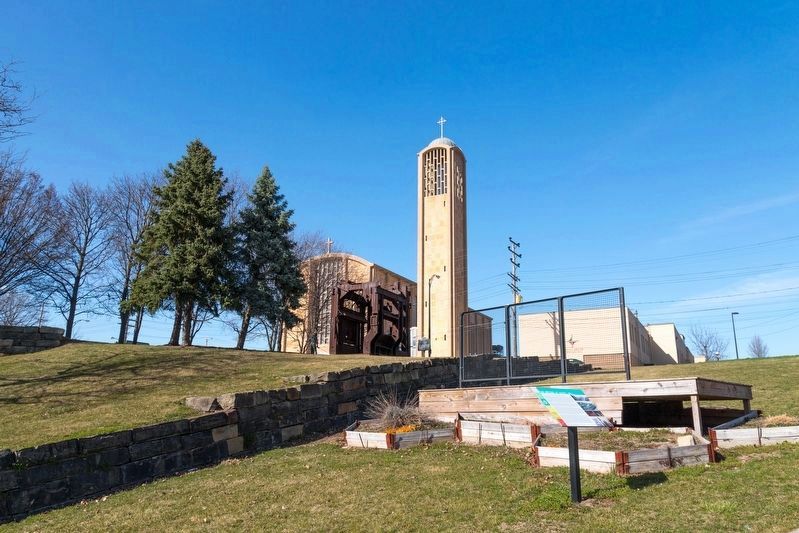
Hazel Hill. Interpretive Panel is in the Foreground.
GEOGRAPHIC SORT Title Sort Marker Number Sort Marker Number Sort for Trails Publication Order Sort Publication Order Sort A Erected Year Sort Most Viewed Sort Most Recent-Interest Sort Most Recently Changed Sort SEE FAQ #33 FOR DESCRIPTIONS
On North Hazel Street south of West Wood Street, on the left when traveling north.
On Wick Avenue at East Federal Street, on the right when traveling north on Wick Avenue.
On Market Street at West Federal Street, on the right when traveling south on Market Street.
On Market Street at Federal Plaza East, on the right when traveling north on Market Street.
On Fifth Avenue at Granada Avenue, on the left when traveling north on Fifth Avenue.
On West Federal Street / Martin Luther King Jr. Blvd at 5th Avenue / Mahoning Avenue, on the left when traveling east on West Federal Street / Martin Luther King Jr. Blvd.
On Market Street (Ohio Route 7) south of Erskine Avenue, on the right when traveling south.
Near West Federal Street 0.1 miles west of South Chestnut Street.
On Market Street at Federal Plaza East, in the median on Market Street.
On West Wood Street at North Hazel Street, on the right when traveling east on West Wood Street.
On Edwards Street near Hawthorne Street, on the right when traveling south.
On Market Street (Ohio Route 7) south of Erskine Avenue, on the right when traveling south.
On Wick Avenue at Lincoln Avenue, on the right when traveling north on Wick Avenue.
Paid Advertisement
On Belmont Avenue at Park Avenue on Belmont Avenue.
On Market Street at West Federal Street, on the right when traveling south on Market Street.
On West Federal Street / Martin Luther King Jr. Blvd near 5th Avenue / Mahoning Avenue, on the left.
On Mahoning Avenue, on the left when traveling east.
On West Federal Street east of Symphony Place, on the right when traveling west.
On Market Street north of East Front Street, on the right when traveling north.
On Wick Avenue at West Federal Street, on the right when traveling south on Wick Avenue.
On West Federal Street east of Chestnut Street, on the left when traveling east. Reported missing.
On West Wood Street at Elm Street, on the left when traveling west on West Wood Street.
On Market Street at West Federal Street, in the median on Market Street.
On South Walnut Street south of East Front Street, on the right when traveling south.
On Market Street at Emily Alley, on the right when traveling north on Market Street.
On Emily Alley at Market Street on Emily Alley.
On Emily Alley at Market Street, on the left when traveling west on Emily Alley.
On Market Street south of Emily Alley, on the right when traveling north.
On Market Street at Emily Alley, on the right when traveling north on Market Street.
Paid Advertisement
On Emily Alley at Market Street on Emily Alley.
On Market Street at Emily Alley, on the right when traveling north on Market Street.
On Warren-Meadville Road (County Route 330) at Wilson-Sharpsville Road (County Route 305), on the right when traveling west on Warren-Meadville Road.
On Warren-Meadville Road (County Route 330) at Wilson-Sharpsville Road (County Route 305), on the right when traveling west on Warren-Meadville Road.
On Warren-Meadville Road (County Route 330) at Wilson-Sharpsville Road (County Route 305), on the right when traveling west on Warren-Meadville Road.
On Warren-Meadville Road (County Route 330) at Wilson-Sharpsville Road (County Route 305), on the right when traveling west on Warren-Meadville Road.
On Warren-Meadville Road (County Route 330) at Wilson-Sharpsville Road (County Route 305), on the right when traveling west on Warren-Meadville Road.
On Warren-Meadville Road (County Route 330) at Wilson-Sharpsville Road (County Route 305), on the right when traveling west on Warren-Meadville Road.
On Braceville Cemetery Road at Newton Falls Braceville Road, on the right when traveling west on Braceville Cemetery Road.
On Saintrte 82 Southwest (Ohio Route 82) at Newton Falls-Braceville Road on Saintrte 82 Southwest.
On Herr Fieldhouse Road (County Road 124) 0.3 miles west of Barclay Messerly Road (County Road 123), on the right when traveling east.
On Painsville-Warren State Road (Ohio Route 45) at Park Drive, on the right when traveling north on Painsville-Warren State Road.
On Greenville Road NW (Ohio Route 88) 0.1 miles east of Route 45, on the right when traveling east.
On Plainville-Warren State Road (Ohio Route 45) at Park Drive, on the right when traveling north on Plainville-Warren State Road.
On Plainville-Warren State Road (Ohio Route 45) at Greenville Road Northwest ( Route 88), on the right when traveling north on Plainville-Warren State Road.
Paid Advertisement
Near Greenville Road NW (Ohio Route 88).
On Ohio Route 45 at Greenville Road NW ( Route 88), on the right when traveling north on Ohio Route 45.
On Plainville-Warren State Road (Ohio Route 45) at Park Drive, on the right when traveling north on Plainville-Warren State Road.
On Greenville Road Northwest (Ohio Route 88) 0.3 miles west of Painesvill-Warren State Road ( Route 45), on the right when traveling west.
On Grove Street near Route 7, on the right when traveling west.
Near Ohio Route 7 0.1 miles north of Grove Street. Reported permanently removed.
Near Ohio Route 7 0.1 miles north of Grove Street.
On Ohio Route 7 at Route 82, on the right when traveling north on Ohio Route 7.
On Ohio Route 7 at Route 82, on the right when traveling north on Ohio Route 7.
On Old 82 (Ohio Route 7) at Warren-Sharon Road, on the left when traveling south on Old 82. Reported missing.
On Ohio Route 7 at Grove Street, on the left when traveling south on Ohio Route 7.
Near South High Street (Ohio Route 5) 0.2 miles south of Fowler Street.
On North Mecca Street (Ohio Route 46) at Liberty Boulevard, on the right when traveling south on North Mecca Street.
On Kinsman Road Northeast at Youngstown-Kingsman Road, on the right when traveling east on Kinsman Road Northeast.
On Youngstown Kingsville Road (Ohio Route 193) at Wilson Sharpsville Road ( Route 305), on the right when traveling south on Youngstown Kingsville Road.
On Youngstown Kingsville Road at Circle Drive, on the left when traveling north on Youngstown Kingsville Road.
Paid Advertisement
On Youngstown Kingsville Road at Circle Drive, on the left when traveling north on Youngstown Kingsville Road.
On North State Street (U.S. 422) at East Prospect Street, on the right when traveling north on North State Street.
On North State Street (U.S. 422) at Smithsonian Street, on the right when traveling north on North State Street.
On Kinsman Road NE (Ohio Route 87) at Route 193, on the right when traveling west on Kinsman Road NE.
On Kinsman Road Northeast, on the right when traveling east.
On Ohio Route 87 at Youngstown-Kingsman Road, on the right when traveling east on Ohio Route 87.
On Ohio Route 7 at Route 305, on the right when traveling south on Ohio Route 7.
On North River Road Northeast (County Route 142) 0.3 miles west of River Glen Road, on the right when traveling west.
On Niles Cortland Road Northeast (Ohio Route 46) at Anderson Road Northeast, on the right when traveling north on Niles Cortland Road Northeast.
On Apple Street at Everett Hull Road (County Route 193), on the right when traveling west on Apple Street.
On Apple Street at Everett Hull Road (County Route 193), on the right when traveling north on Apple Street.
On Main Street (Ohio Route 7) 0.1 miles north of Church Street, on the right when traveling south.
On Williamsfield-Kinsman Road (County Route 277) at Church Street (Route 270), on the right when traveling north on Williamsfield-Kinsman Road.
On Ohio Route 5 at Route 7, on the left when traveling east on Ohio Route 5.
On Church Street (County Route 270) at Ridge Road, on the right when traveling west on Church Street.
On Church Street (County Route 720) at Ridge Road, on the right when traveling west on Church Street.
Paid Advertisement
On Church Street (Route 270) at Williamsfield-Kinsman Road (County Route 277), on the right when traveling west on Church Street.
On Kinsman-Nickerson Road (Ohio Route 5) at Williamsfield-Kinsman Road ( Route 7), on the right when traveling west on Kinsman-Nickerson Road.
On West Market Street, on the right when traveling east.
On West Market Street, on the right when traveling east.
On West Market Street west of South Leavitt Road, on the right when traveling east.
On West Market Street, on the right when traveling east.
On Cemetery Drive (County Route 1045) at Phelps Creek Road ( Route 534), on the right when traveling east on Cemetery Drive.
On Phelps Creek Road (Ohio Route 534) at Kinsman Road ( Route 87), on the right when traveling north on Phelps Creek Road.
On Phelps Creek Road (Route 534) at Park Drive (County Route 898), on the right when traveling north on Phelps Creek Road.
On Phelps Creek Road (Ohio Route 534) at Park Drive, on the right when traveling north on Phelps Creek Road.
On Phelps Creek Road (Ohio Route 534) at Kinsman Road ( Route 87), on the right when traveling north on Phelps Creek Road.
On Phelps Creek Road (Ohio Route 534) at Kinsman Road ( Route 87), on the right when traveling south on Phelps Creek Road.
On Phelps Creek Road (Ohio Route 534) at Kinsman Road ( Route 87), on the right when traveling north on Phelps Creek Road.
Near Kinsman Road (Route 87) at Phelps Creek Road ( Route 534), on the right when traveling west.
On Phelps Creek Road (Ohio Route 534) 0.4 miles south of Kinsman Road NW ( Route 87), on the right when traveling south.
On Salt Springs Road at Meander Dam Road, on the right when traveling east on Salt Springs Road.
Paid Advertisement
On Stewart Street at South Main Street ( Route 46), on the right when traveling east on Stewart Street.
On Salt Springs Youngstown Road 0.3 miles west of South Main Street ( Route 46), on the right when traveling south.
On Arlington Road, on the right when traveling west.
On River Street at North Milton Boulevard, on the right when traveling west on River Street.
On River Street at East Jay Street on River Street.
︽
363 entries matched your criteria. Entries 201 through 300 are listed above.
⊲ Previous 100 —
The final 63 ⊳