On the Bloomington Road
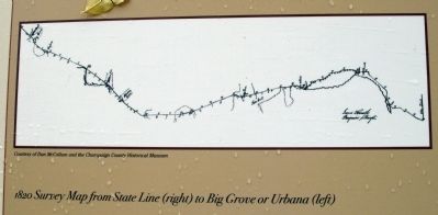
The Fort Clark Road, later known as the Bloomington or State Road, was an important artery for commerce between Danville and Urbana. The road was first approved in 1826 by the Illinois Assembly. It was the first . . . — — Map (db m23850) HM
(Top Section)
Champaign County was always on Lincoln’s circuit. Abraham Lincoln spent nearly 20 years of his life practicing law on the 8th Judicial Circuit, traveling from one county seat to another. Even as the circuit shrank while . . . — — Map (db m24340) HM
Lincoln’s Mahomet
Upper Section
The village of Middletown-Mahomet was platted by Daniel Porter in 1832 on the west bank of the Sangamon River near its headwaters. The main street of the village was actually a new road, made necessary by . . . — — Map (db m24374) HM
Kelley’s Tavern was originally called Strong’s Inn after Cyrus Strong, who built a mud-mortar log cabin here in the 1830's. The inn at Strong’s Ford was a stop on the Bloomington or State Road from Danville west to Urbana. Kelley’s Inn was a stop . . . — — Map (db m23803) HM
Abraham Lincoln made his farewell address to the people of Illinois at the Tolono Station February 11, 1861. "I am leaving you on an errand of national importance, attended as you are aware with considerable difficulties. Let us believe as some poet . . . — — Map (db m4720) HM
Abraham Lincoln traveled through Tolono by locomotive at least eighteen times. He whiled the time away for his train connections by playing horseshoes and visiting with the Tolono residents. While campaigning in Illinois, Lincoln would frequently . . . — — Map (db m23816) HM
Top Section
During the Spring term of the Circuit Court in 1858, Abraham Lincoln sat for a portrait with photographer Samuel Alschuler. Alschuler’s studio was on the second floor of the Lowenstern Building, at the southwest corner of . . . — — Map (db m31120) HM
Top Section
Murder, larceny, and even rape- - -the young circuit lawyer Abraham Lincoln, practicing in Urbana, handled cases involving all of these in the courthouse which stood on this city block. Lincoln unsuccessfully defended . . . — — Map (db m31119) HM
(front of statue, which is the last line from Lincoln's Gettysburg Address:)
That we here highly resolve that these dead shall not have died in vain, that this notion under God shall have a new birth of freedom - and that government of . . . — — Map (db m188398) HM WM
“I had pleasant accommodations at Taylorville in company with Mr. Lincoln & Mr. Thorton,” Circuit Judge David Davis once wrote from here.
He found this town–the last county seat on his circuit route–to be . . . — — Map (db m12208) HM
This structure was erected in 1841 by Col. Wm. B. Archer, founder of Marshall, and John Bartlett and has been in continuous use as a hotel. It was an important stage coach stop on the early Cumberland Road where many prominent people, including . . . — — Map (db m152564) HM
On December 25, 1830, the Illinois General Assembly created Coles County. At this time, Charleston became the county seat and was just a hamlet called "Coles Courthouse." In 1831, a log-cabin courthouse was constructed. About four years later, a . . . — — Map (db m188293) HM
Side One
Top Section
Nineteenth-century Illinois political campaigns and rallies were raucous affairs, part entertainment and part serious politics. The candidates were often accompanied or preceded by marchers, fireworks, flag . . . — — Map (db m30866) HM
Left Section
Abraham Lincoln was a frequent visitor to Cole County in the 1840's, traveling on the judicial circuit. In Charleston, according to Amanda Hanks Poorman (the daughter of Dennis Hanks), Lincoln would use the Hanks’s horse . . . — — Map (db m30847) HM
Here on January 31, 1861, President-Elect Abraham Lincoln visited his stepmother, Mrs. Sarah Bush Lincoln and her daughter Mrs. Reuben Moore (Matilda Johnston). This was his last visit to Coles County before leaving Illinois for his inauguration. . . . — — Map (db m30888) HM
In Shiloh Cemetery are the graves of Thomas and Sarah Lincoln, father and step-mother of Abraham Lincoln. On January 31, 1861, shortly before assuming the presidency, Lincoln came here from Springfield to visit his father's grave in company with his . . . — — Map (db m188284) HM
In 1837 Thomas Lincoln erected a cabin on a tract of land situated one-half mile to the east. Here he resided until his death in 1851. Abraham Lincoln visited here frequently, and after 1841 held title to forty acres of land on which his parents . . . — — Map (db m30933) HM
Left Panel: “This will certify that the foregoing plot of the town of Farmington laid by me as proprietor is correct.
Witness my hand and seal this 30th day of April 1852.”
J. J. . . . — — Map (db m30979) HM
Thomas Lincoln, father of the sixteenth President, died in 1851. He was buried in what was then called the Gordon Burial Ground, which today is known as the Thomas Lincoln Cemetery. As was common in many rural cemeteries, Thomas Lincoln's . . . — — Map (db m188289) HM
From 1831 to 1834 Thomas and Sarah Lincoln, father and stepmother of Abraham Lincoln, lived in a cabin which stood a short distance to the north. It was their first home in Coles County, and their second home in Illinois. — — Map (db m188282) HM
Side OneTop Section
Abraham Lincoln’s last visit to Cole County was indeed of a personal nature. Lincoln was described as he left Springfield by Henry C. Whitney, who accompanied him part of the way on the train: “. . . . . . — — Map (db m30840) HM
Top Section
Dr. Hiram Rutherford was a key person involved in Abraham Lincoln’s famous slave case, the only instance in his career where Lincoln represented the rights of a slave owner. Robert Matson brought slaves from Kentucky to work his . . . — — Map (db m30867) HM
William Henke was an executive at the Blue Island Ice Company and served as assessor, clerk, and road commissioner for the Township of Worth. He was also the Third Ward alderman. John Kauffman, a prominent Blue Island contractor, built the house for . . . — — Map (db m297937) HM
United States Senator Stephen Douglas, who died in 1861 at the age of forty-eight, was a firm believer in the future of Chicago. He held states offices and became nationally known for his debating skill in the Senate and in his campaign against . . . — — Map (db m120728) HM
Chicago’s Boulevards are one of the city’s most overlooked treasures, and one of the largest and oldest boulevard systems in the nation. The 28-mile system contains 540 acres of green space, and provides a link between seven inland parks and . . . — — Map (db m314155) HM
Chicago’s Boulevards are one of the city’s most overlooked treasures, and one of the largest and oldest boulevard systems in the nation. The 28-mile system contains 540 acres of green space, and provides a link between seven inland parks and . . . — — Map (db m314205) HM
Lincoln Park was created in response to concerns in the
1850's about the public health threat posed by a lakeside
cemetery. An unused section of the burial ground was
reserved as Lake Park in 186o, and renamed shortly after
President Abraham . . . — — Map (db m189175) HM
One of the oldest and most important public sculptures in Chicago, this monument to America’s sixteenth president influenced a generation of sculptors due to its innovative combination of a natural-looking Lincoln-–depicted deep in thought as . . . — — Map (db m47815) HM
Lincoln Park was created in response to concerns in the 1850's about the public health threat posed by a lakeside cemetery. An unused section of the burial ground was reserved as Lake Park in 186o, and renamed shortly after President Abraham . . . — — Map (db m261263) HM
Here began the Little Fort Road. Now Lincoln Avenue and Indian Trail which became main road to Little Fort or Waukegan the first important settlement north of Chicago
Erected by
Chicago's Charter Jubilee
Authenticated by Chicago . . . — — Map (db m261216) HM
The section of the boulevard system north of Humboldt Park dates to the late 1870s, when the park first opened. As a result, this entire portion—present-day Kedzie and Logan boulevards and Logan and Palmer squares—originally was called Humboldt . . . — — Map (db m273243) HM
Chicago’s Boulevards are one of the city’s most overlooked treasures, and one of the largest and oldest boulevard systems in the nation. The 28-mile system contains 540 acres of green space, and provides a link between seven inland parks and . . . — — Map (db m273249) HM
Douglas Park, the southernmost of the three great West Side parks, was named in honor of Chicago resident Stephen A. Douglas (1813-61), a United States Senator most remembered for his debates with Abraham Lincoln in the 1860 presidential election. . . . — — Map (db m249329) HM
From 1847 until his death in 1861, Stephen Douglas was both a powerful U.S. senator and an influential Chicago resident. Douglas moved from Vermont to southern Illinois at age 20 to begin his career in law and politics, rising quickly among the . . . — — Map (db m235224) HM
Hog Butcher for the World. Tool Maker, Stacker of Wheat, Player with Railroads and the Nation's Freight Handler; Stormy, husky, brawling. City of the Big Shoulders...
The first five lines from Sandburg's 1914 poem . . . — — Map (db m234538) HM
The seeds of the Second Presbyterian Church originated on the banks of the Chicago River under the pastoral guidance of Rev. Jeremiah Porter, in 1833. In 1835, the church was formally incorporated as the First Presbyterian Church and Society of . . . — — Map (db m267801) HM
Named for brothers Ira and James Couch, owners of the Tremont Hotel which stood at Lake & Dearborn streets from 1850 to 1871. Chicago's first brick building, the Tremont hosted President Abraham Lincoln when he visited Chicago. — — Map (db m245008) HM
Named for brothers Ira and James Couch, owners of the Tremont Hotel which stood at Lake & Dearborn streets from 1850 to 1871. Chicago's first brick building, the Tremont hosted President Abraham Lincoln when he visited Chicago. — — Map (db m245011) HM
General John S. Wilcox
Sec. 1B Lot 1 Space 12
1833-1926
&
General William Lynch
Sec. 11 Lot 133 Space 2
1839-1876
Bluff City Cemetery
Elgin, Illinois
This marker commemorates the lives and service of General's John Shuler . . . — — Map (db m299909) HM WM
[First tablet on the left:]
American Civil War
April 12, 1861 April 26, 1865
Initiating the conflict between the industrial based north and agriculturally based south was the southern bombardment of Fort Sumter on April 12, 1861. This . . . — — Map (db m245161) WM
Following a path worn by buffalo, Native Americans traveled the length of the eastern border of Illinois. French fur trapper-traders utilized the same trail. Gurdon Saltonstall Hubbard, a fur trader for John Jacob Astor’s American Fur Trading . . . — — Map (db m87082) HM
In memory of La Grange men
who served in the Civil War, the Spanish-American War and the World War. This staff is dedicated by American Legion Post No. 41 of La Grange, May 30, 1923
"The mystic chords of memory stretching from . . . — — Map (db m252075) WM
[Plaque at bottom left of south-facing side:]
Nearly 300 men from Lemont Township served in the American Civil War including John Warden who recieved the Medal of Honor for valor at Vicksburg. The Old Lemont Methodist Church was a recruiting post . . . — — Map (db m295514) HM WM
Built circa 1858 of "Athens marble" as the Chicago & Alton Railroad station. The first train passed through Lemont on March 18, 1858. In 1865, the townspeople gathered here in silent tribute to Abraham Lincoln as his funeral train passed slowly . . . — — Map (db m295500) HM
Is it possible to wave the flag too much? Provided, of course, that you wave it with integrity? Is it possible to study Lincoln or Shakespeare too much? Is it possible to read the Bible too much ★ The great, the good, the true, are . . . — — Map (db m274331) HM
May the souls of those who perished because of the events on this day rest in peace and let this monument remind all who gaze upon it of the heroism displayed by our fellow citizens, especially that of the American Fire Service.
. . . — — Map (db m274340) HM
Here stood the Dubois Tavern. Jesse K. Dubois, a close friend of Abraham Lincoln, was an official in the United States Land Office in Palestine from 1849-1853 and later became the Auditor of Public Accounts for Illinois. His son, Fred T. Dubois, . . . — — Map (db m23309) HM
A United States Land Office was located at this site in 1820 and operated until 1855. Settlers from as far as Chicago came here to file on homesteads.
Young Abraham Lincoln passing through Palestine in 1830 with his family in emigrant wagons . . . — — Map (db m23316) HM
[column 1:]
"History of The National Road"
Settlers had been moving west since the early 1700's. By 1802, so many farms and towns had been settled in the Ohio Valley that people living in the territory were calling for . . . — — Map (db m155631) HM
Twenty-one year old Abraham Lincoln, his father, Thomas, and his step-mother, Sarah Bush (Lincoln), along with various relatives, passed through here while traveling the Palestine Road in 1830. A broken wagon forced the family to stop, perhaps for . . . — — Map (db m229856) HM
Abraham Lincoln attended court in Cumberland County on several occasions. One occasion was in 1847 in the case of the People of the State of Illinois vs. Sigler H. Lester, who was accused of assault with a deadly weapon, with intent to murder. . . . — — Map (db m229858) HM
The Citizens of De Kalb erect this memorial to commemorate forever the loyalty and heroism of those of their number who answered the call of humanity in the World War
1914 – 1918
"That government of the people, by the people, . . . — — Map (db m310042) WM
[Front panel:]
DeKalb County
To the memory of the men who fought to preserve the Union: "That the nation shall under God, have a new birth of freedom, and that government of the people, by the people and for the people shall not perish from . . . — — Map (db m257950) WM
“You can fool all the people part of the time and part of the people all the time, but you can not fool all the people all the time.”
Spoken in an address in Clinton July 27, 1858 by
Abraham Lincoln
“I must stand with anybody that . . . — — Map (db m11030) HM
During the twenty years Abraham Lincoln attended the DeWitt County Court on the Eighth Judicial Circuit, he and Clifton H. Moore, Clinton’s first resident attorney, developed a deep friendship as well as a mutual law practice.
The two men . . . — — Map (db m24298) HM
Barnett Tavern, owned and operated by Alvin and Rebecca Barnett, stood at 200 South Center Street. The two-story home was a stopping-place for weary travelers, circuit lawyers, and judges journeying across the Illinois prairie. When in Clinton, . . . — — Map (db m24236) HM
During his twenty years on the Eighth Judicial Circuit, Abraham Lincoln tried numerous cases in the DeWitt County courthouses, including a slander case involving William Dungey. Dungey, “a dark skinned man of Portuguese descent,” married . . . — — Map (db m24237) HM
Top SectionDeWitt County was part of the Eighth Judicial Circuit from its beginning, and so was Abraham Lincoln, who attended the first session of DeWitt Circuit Court in Clinton on October 24, 1839. Court sessions were held each . . . — — Map (db m24321) HM
Top Section
This satirical February 1863 editorial illustration, titled “The Copperhead Party, “ depicts three Copperheads advancing on Columbia. Copperheads were Southern sympathizers who saw themselves as “Peace Democrats,” opposed to . . . — — Map (db m24235) HM
A proper Presbyterian Church was under construction in the summer of 1859. A floor was laid, walls, roof, and belfry nearly completed, when “a halt due to lack of funds” occurred. In October 1859, money was urgently needed to . . . — — Map (db m24247) HM
Top Section
Clifton H. Moore, DeWitt County’s first resident attorney, built this stately brick home in 1857-58 on an eighty-acre tract of land purchased from Judge David Davis. The original house suffered damage from a windstorm and now lacks . . . — — Map (db m24301) HM
Left Section
When Lincoln called for troops to defend the Union, the men and boys of DeWitt County heeded his urgent request. Some who volunteered were from families who had know and befriended Lincoln during his days as a prairie lawyer . . . — — Map (db m24253) HM
Warner's Memories
Top Section
Lincoln traveled the Eighth Judicial Circuit six months a year, becoming close friends with his fellow lawyers, with whom he shared, not only courtroom, but also meals, an easy camaraderie, and often a . . . — — Map (db m24325) HM
The Law and Lodging
Top Section
During his years traveling the Eighth Judicial Circuit, Abraham Lincoln was the overnight guest of many DeWitt County residents. As a frontier lawyer, he spent several months per year . . . — — Map (db m24371) HM
Israel and Avis Blodgett moved to Downers Grove in 1836. Israel Porter Blodgett, Sr. operated a blacksmith shop, and is credited with developing the self-scouring plow used to turn the Illinois prairie.
Israel & Avis Blodgett were against . . . — — Map (db m270857) HM
A few thoughts about democracy:
Democracy is "government of the people, by the people, for the people"
-Abraham Lincoln
"Man's capacity for justice makes democracy possible, but man's inclination to injustice makes democracy . . . — — Map (db m304936) HM
Abraham Lincoln was 30 years old in 1839, Storytelling and humor defined Lincoln's reputation as he grew from chopping wood, storekeeping and "riding" the Eighth Circuit, to leading a divided nation. He and Joe Naper, our city's founder, served in . . . — — Map (db m290309) HM
Paris lies in the heart of a rich farming area. Most of the land embraced in Edgar County, including Paris, remained Kickapoo hunting grounds until 1819, but the eastern quarter of the county was part of a tract ceded by the Indians in 1809 and . . . — — Map (db m188363) HM
Spoke in the oak grove of General William Pickering north of here in the presidential campaign of 1840. He was stumping southern Illinois as a Whig elector for General William Henry Harrison in the Tippecanoe and Tyler Too Campaign. In 1861 . . . — — Map (db m154578) HM
The store of Ebenezer Capps was located just north of this site at the northeast corner of Main and Fourth streets.
The location of Main street is not the same today as when Lincoln was here. Vandalia existed long before the coming of . . . — — Map (db m42486) HM
On December 1, 1834 Abraham Lincoln entered the State Capitol that stood on this site. This was his first term as a state representative and the first time he held elective office. The Abraham Lincoln that began his political career on that . . . — — Map (db m42510) HM
At the beginning of Lincoln's second term as a state representative, several southern legislatures were concerned that the Federal Government would abolish slavery in the District of Columbia. Most of the members of the Illinois Legislature . . . — — Map (db m42490) HM
Born in Hanover. Died Feb. 3, 1847. Member of Ernst Colony. Builder and operator of Vandalia Hotel. Merchant. Daughter, Olivia Whiteman, friend of the Abraham Lincoln family, unveiled Madonna of the Trail statue. — — Map (db m42384) HM
In Lincoln’s first campaign speech on March 9, 1832, he expressed support for internal improvements.
“Time and experience have verified to a demonstration, the public utility of internal improvements. That the poorest and most . . . — — Map (db m42512) HM
The delegation from Sangamon County for the 1836-1837 Session of the legislature quickly became known as the "Long Nine."
The seven representatives and two senators were all six feet or taller. Five were lawyers, three were farmers, and one . . . — — Map (db m42485) HM
On December 5, 1836 Abraham Lincoln attended the opening session of the Tenth Gereral Assembly in Vandalia. This session was held in a new building just recently completed by the citizens of Vandalia to serve as the State Capitol. It was . . . — — Map (db m42517) HM
On June 12, 1823, the Third General Assembly, meeting in the newly formed city of Vandalia, conveyed one and one-half acres of land to the city of Vandalia, with the proviso that the land be used as a burial ground. This is the location of that . . . — — Map (db m42428) HM
Abraham Lincoln traveled past this spot while he served as a state representative in Vandalia. This location marks the route of a road that ran from Vandalia to Springfield, Illinois. Traces of the roadway are still visible today. The roadway . . . — — Map (db m42527) HM
The second state capitol owned by the State was a two-story brick building erected here in 1824, using the walls of the first State Bank which burned January 28, 1823. Abraham Lincoln was a member of the House in the 1834-1835 and 1835-1836 . . . — — Map (db m42351) HM
The third capitol building owned by the state was restored as a memorial in 1933. It was the capitol from December 3, 1836 to July 4, 1839. Abraham Lincoln was a member of the House during the three sessions of the legislature held in this . . . — — Map (db m42346) HM
Not all of Lincoln’s time was dedicated to noble causes like opposing slavery and championing internal improvements. In 1833, Mrs. Bennett Abell, a New Salem neighbor of Lincoln, brought her sister Mary Owens to New Salem for an extended visit. . . . — — Map (db m42521) HM
Come inside and live the story of the Historic National Road, the road that built the nation. Just thirty years after declaring independence from the British, the young nation was feeling the growing pains of westward expansion. President Thomas . . . — — Map (db m144185) HM
As the Illinois State Capital, Vandalia provided many hotels to serve the needs of legislators and visitors. Vandalia had at least eleven hotels that served the needs of travelers. Whenever a session of the legislature was in progress, these . . . — — Map (db m144134) HM
Lincoln had come to know Lewistown residents quite well before his famous speech on August 17, 1858. Some of them he met before they became residents of Lewistown, others during his circuit riding days practicing law and pursuing a political career. . . . — — Map (db m267315) HM
Lewistown Trail, from Springfield to Galena via Lewistown, was one of the main routes to the Galena Lead Mines from 1827 to 1837. The Trail crossed the Illinois River at Havana, where Ossian M. Ross, the founder of Lewistown, operated a ferry. He . . . — — Map (db m129216) HM
1330 entries matched your criteria. Entries 201 through 300 are listed above. ⊲ Previous 100 — Next 100 ⊳