Near 2nd Street NW (Business U.S. 460) at Maple Road. Reported damaged.
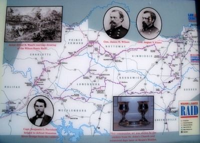
In late June 1864, Confederate Gen. Robert E. Lee and the Army of Northern Virginia were engaged in a desperate defense of the city of Petersburg. Victory for Lee depended on a steady flow of supplies, brought in by rail. To force Lee from . . . — — Map (db m263002) HM
On W Virginia Avenue (U.S. 460) at Meade Street, on the left when traveling north on W Virginia Avenue.
Originally called Robertson’s switch, near here General Grant made a cross-country night ride through enemy territory to join Generals Sheridan and Meade at Jetersville. Here, plans would be made for operations against Lee’s army the following day. . . . — — Map (db m6076) HM
Near West Courthouse Road 0.1 miles south of Old Nottoway Road. Reported permanently removed.
Following the South Side railroad, portions of the Union army passed through this village and continued through Burkeville, encountering the Confederates at Rice's Depot. General Grant spent part of the evening here before riding to Jetersville to . . . — — Map (db m18878) HM
On Cornwallis Avenue, on the right when traveling east.
Before Sunset on May 6, 1864 From this site, you would have seen Confederate Brig. Gen. John B. Gordon quietly assembled ten regiments between here and the woods, across the lake, at Madison Cir. In those woods, Union Brig. Gen. T. Seymour had . . . — — Map (db m65280) HM
On Constitution Highway (State Highway 20), on the right when traveling west.
The Battle of the Wilderness On May 5, 1864, Lee moved swiftly eastward through Orange County and struck the Federals along two roads - the Orange Plank Road and the Orange Turnpike. Two bloody, largely separate battles exploded. They would . . . — — Map (db m7392) HM
On Constitution Highway (State Highway 20), on the right when traveling west.
Collision of Giants By 1864 the war had become not just a clash of armies, but of ideas. To be resolved on the fields of Virginia and Georgia that year was not only the fate of the Union, but also the fate of Southern society. The armies on both . . . — — Map (db m6077) HM
On Germanna Highway (Virginia Route 3) at the Germanna Community College Entrance ( Route 375), on the right when traveling south on Germanna Highway. Reported permanently removed.
In March 1864, President Abraham Lincoln placed Gen. Ulysses S. Grant in charge of the Union’s overall military effort. Grant’s strategy was simple: attack the Confederates simultaneously on all fronts, overwhelming them by sheer force of numbers. . . . — — Map (db m3587) HM
On Germanna Highway (Virginia Route 3) north of the Germanna Community College Entrance ( Route 375), on the right when traveling south. Reported permanently removed.
When the 1864 Overland Campaign started, Gen. Robert E. Lee’s Army of Northern Virginia held the upper fords of the Rapidan River, blocking the Union army's route to Richmond. Rather than attack Lee head on, Grant chose to cross here at Germanna . . . — — Map (db m3588) HM
On College Drive (Virginia Route 375) 0.2 miles west of Germanna Highway ( Route 3), on the right when traveling east.
At dawn on May 4, 1864, the 3rd Indiana Cavalry splashed across the river here at Germanna Ford and scattered the handful of Confederate pickets to secure the passage. Upon engineers quickly threw down two pontoon bridges and the army began . . . — — Map (db m171388) HM
Near Constitution Highway (State Highway 20), on the right when traveling west.
Union reinforcements rushed to the sound of fighting as twilight turned to darkness in these gloomy woods. The Confederates lost direction and momentum in the smoky gloaming, and eventually the firing died away. Gordon's attack had achieved only a . . . — — Map (db m7389) HM
On College Drive (Virginia Route 375) 0.2 miles west of Germanna Highway ( Route 3), on the right when traveling west.
President Abraham Lincoln placed Lt. Gen. Ulysses S. Grant in charge of the Union's overall strategy in March 1864. The new commander brought fresh energy to the Federal war effort, and developed a strategy whereby Union armies would . . . — — Map (db m171416) HM
On Constitution Highway (Virginia Route 20) 1.7 miles west of Germanna Highway ( Route 3), on the right when traveling west.
On no American battlefield did the landscape do more to intensify the horror of combat. One soldier called the Wilderness "a wild, weird, region... [a] dense and trackless forest." For decades loggers had cut and re-cut these forests to fuel nearby . . . — — Map (db m155691) HM
On Flank Road at Crater Road (Highway 301), on the left when traveling east on Flank Road.
After four days of unsuccessful trying to capture Petersburg by direct assault on June 15-18, 1864, Gen. U.S. Grant’s Union army began siege operations against the city. Grant’s immediate objective was to cut one of Gen. Robert E. Lee’s supply . . . — — Map (db m195799) HM
On East Old Street at Rock Street, on the right when traveling east on East Old Street.
Pamplin Historical Park & The National Museum of the Civil War Soldier
“Walk along these fortifications, take the time to learn something about the story of what happened here, use the museum to understand who these men were, and the . . . — — Map (db m57351) HM
On East Old Street at Rock Street, on the right when traveling east on East Old Street.
Beginning on June 15, 1864, less than three miles east of where you are standing, 18,000 Union troops attacked the Confederate line of defensive fortifications surrounding the city. When all attempts to take the city by direct assault failed by June . . . — — Map (db m175034) HM
On East Old Street at Rock Street, on the right when traveling east on East Old Street. Reported permanently removed.
The Petersburg Area. Throughout this area you will find attractions for the entire family, from museum houses and gardens to a zoo, from fine dining to camping, from Civil War Trails and battlefields to white-water kayaking.
Charles . . . — — Map (db m57322) HM
On West Washington Street (U.S. 1) at North Market Street, on the left when traveling west on West Washington Street. Reported permanently removed.
Half a block south is the home of Major General William Mahone, famed for his gallant conduct at the Battle of the Crater, July 30, 1864. Two blocks south is the Wallace Home, where Abraham Lincoln conferred with General Grant, April 3, 1865, . . . — — Map (db m17553) HM
On West Washington Street (U.S. 1) at Sout Market Street, on the right when traveling east on West Washington Street.
South Market Street became a fashionable address for Petersburg's elite in the mid-19th century. Two blocks south of here is the Thomas Wallace house, built in 1855, which served as Lt. Gen. Ulysses S. Grant's headquarters after the fall of . . . — — Map (db m292537) HM
On North Main Street (Virginia Route 45), on the right when traveling south.
Half-starved and exhausted, the vanguard of the Army of Northern Virginia stumbled into Farmville early on the morning of April 7, 1865. Here, at last, the men found long-promised rations – everything from bread to soup and ham. While the head of . . . — — Map (db m290954) HM
On South Main Street (Business U.S. 15) at 4th Street, on the right when traveling north on South Main Street.
Main Street
Once named Bizarre in 1736, Farmville was established as a town in 1798. From the town's formation, tobacco was a major factor in its prosperity. The numerous warehouses along the Main Street corridor represent . . . — — Map (db m31352) HM
On North Main Street (State Highway 45) at East Second Street, on the right when traveling north on North Main Street.
Here stood the hotel where General U.S. Grant made his headquarters April 7, 1865, and opened correspondence with General R.E. Lee which terminated in the surrender of the Army of Northern Virginia at Appomattox Court House two days later. From the . . . — — Map (db m30252) HM
On Courthouse Road (Virginia Route 106), on the right when traveling west.
In June 1864, Gen. U.S. Grant began to confine Gen. Robert E. Lee’s Army of Northern Virginia within the Richmond and Petersburg defenses. The South Side R.R., connecting Petersburg and Lynchburg, and the Richmond and Danville R.R. supplied Lee’s . . . — — Map (db m14771) HM
On Ruffin Road (Virginia Route 106) at Old Stage Road, on the right when traveling east on Ruffin Road.
As the summer of 1864 ended with Union Gen. U.S. Grant’s army still laying siege to Petersburg, Southern sources learned of a large herd of cattle being held at nearby Coggin’s Point on the James River. The cattle were grazing at “Beechwood,” the . . . — — Map (db m14773) HM
On Centreville Road (Virginia Route 28), on the right when traveling north.
After nearly four years at Appomattox Court House, Wilmer McLean and his family returned to Prince William County in 1867. McLean still owned the 985-acre Yorkshire Plantation and lived there, but wartime devastation and the end of slavery brought . . . — — Map (db m40074) HM
On Canal Walk east of South 14th Street, on the right when traveling east.
Pres. Abraham Lincoln traveled up the James River from City Point and entered Richmond near 17th Street on 4 April 1865. Word of his arrival spread quickly, sparking a joyous celebration of newly freed African Americans surrounded him. Lincoln . . . — — Map (db m216631) HM
On Meigs Lane 0.1 miles east of John Wayland Highway ( Route 42), on the left when traveling east. Reported permanently removed.
The death of Union Lt. John R. Meigs, near the granite marker on the hill in front of you, unleashed a firestorm of retaliation. Gen. Philip H. Sheridan, erroneously told that civilian “bushwhackers” had killed Meigs, reported to Gen. U.S. Grant . . . — — Map (db m15123) HM
On Old Valley Turnpike (U.S. 11) north of New Market, on the right when traveling south.
General U.S. Grant's plan to defeat the Confederacy in 1864, called for a raid by General G. Crook into southwestern Virginia. General F. Sigel, to keep the Confederates from concentrating against Crook, was to advance down Shenandoah Valley from . . . — — Map (db m201543) HM
On Old Valley Pike (U.S. 11) south of Battlefield Road, on the right when traveling south.
General U.S. Grant's plan to defeat the Confederacy in 1864, called for a raid by General G. Crook into southwestern Virginia. General F. Sigel, to keep the Confederates from concentrating against Crook, was to advance down Shenandoah Valley from . . . — — Map (db m253892) HM
On Valley Pike (U.S. 11) 0.4 miles north of Quarry Road, in the median.
When Gen. U.S. Grant came East to assume command of all Union forces in 1864, he ordered Gen. Franz Sigel to seize control of the Valley. As Sigel moved south along the Valley Turnpike, Confederates on May 9, 1864, burned the bridge here delaying . . . — — Map (db m636) HM
Near Park Lane at Old Valley Pike (U.S. 11), on the left when traveling east. Reported missing.
During the evening of October 8, 1864, Gen. Lunsford L. Lomax reached this position with two brigades of Confederate cavalry commanded by Gen. Bradley T. Johnson and Col. William L. "Mudwall" Jackson. Gen. Wesley Merritt, in command of the Union . . . — — Map (db m249063) HM
On West Court Street at School Street, on the right when traveling east on West Court Street. Reported missing.
In the midst of the 1864 Valley Campaign, Woodstock bore witness to the horrors of war. Plagued by raiding parties of Confederate partisan rangers, guerrillas and bushwhackers, Union General Philip H. Sheridan issued orders by mid-August to execute . . . — — Map (db m214994) HM
On Massaponax Church Road (County Route 608) 0 miles west of U.S. 1, on the right when traveling west.
Two weeks of fighting at Spotsylvania had resulted in a bloody draw. On May 21, 1864, the Army of the Potomac left its trenches outside the village and began moving east and south, hoping to lure the Confederates into the open where it could attack . . . — — Map (db m1726) HM
On Patriot Highway (U.S. 1) 0.1 miles south of Massaponax Church Road (County Route 608), on the left when traveling south.
On 4 May 1863, the ambulance bearing wounded Confederate Maj. Gen. Thomas J. (“Stonewall”) Jackson from the Chancellorsville battlefield turned east here en route to Guinea Station, where he died on 10 May. A year later, Union troops of the Army of . . . — — Map (db m1717) HM
Near Old Salem Church Road near Plank Road ( Route 3).
Salem Baptist Church was one of nearly a dozen churches that dotted northern Spotsylvania County on the eve of the Civil War. Zoan, Wilderness, Massaponax, Zion, Christ, Piney Branch – They collectively served as the backbone of the Spotsylvania . . . — — Map (db m3499) HM
On Burnside Drive north of Courthouse Road ( Route 208), on the right when traveling south.
While the May 12 combat at the Bloody Angle marked the height of the Spotsylvania fighting, it was not the end of it. For nine more days, the Army of the Potomac hovered around the village, looking for opportunities to strike. Finding Lee heavily . . . — — Map (db m66237) HM
On Grant Drive 0.1 miles north of Brock Road (County Route 613), on the left when traveling north.
A Different Kind of War With the 1864 Overland Campaign, the war in Virginia changed. The old pattern of fight, retreat, and rest yielded to Ulysses S. Grant's relentless maneuvering and fighting. Attacked in superior force by an incessant foe, . . . — — Map (db m10716) HM
On Sawtooth Lane west of Catharpin Road, on the left when traveling west.
On May 4, 1864, Union Brig. Gen. Edward Ferrero, leader of the all-Black 4th Division, Ninth Army Corps, was ordered by Lt. Gen. Ulysses S. Grant to defend the supply train crossing the Rapidan River at Germanna Ford ahead of the Battle of the . . . — — Map (db m297209) HM
On Brock Road (County Route 613) at Orange Plank Road (County Route 621), on the right when traveling south on Brock Road.
Before the Wilderness, battlefield stalemate meant retreat by one side or the other - a return to the starting point to try again another day. But not here. Union General-in-Chief Ulysses S. Grant rendered stalemate in the Wilderness irrelevant. . . . — — Map (db m4967) HM
Near Catharpin Road (County Route 612) 0.9 miles Old Plank Road (County Route 610), on the right when traveling south. Reported permanently removed.
Known as The Wilderness, the land is comprised of approximately 9,000 acres of rolling fields and dense woods and was the site of what became the first stage of an epic a confrontation between the armies of Ulysses S. Grant and . . . — — Map (db m297213) HM
On Brock Road (County Route 613) at Catharpin Road (County Route 612), on the right when traveling south on Brock Road.
After two days on inconclusive fighting in the Wilderness, Union Gen. U.S. Grant determined to push on to Spotsylvania Court House, ten miles south. Possession of the roads near Spotsylvania would give the Army of the Potomac the inside track, . . . — — Map (db m3589) HM
On Brock Road (County Route 613) at Catharpin Road (County Route 612), on the right when traveling south on Brock Road.
En route to Spotsylvania, Union Gens. U.S. Grant and George Meade halted at Todd’s Tavern, a country inn that once occupied this site. Finding all the beds taken, the generals stretched out to rest on the dirt floor. In the morning, a military band . . . — — Map (db m3590) HM
Near Catharpin Road (County Route 612) 0.9 miles south of Old Plank Road (County Route 610), on the right when traveling south. Reported permanently removed.
Both politicians and the public were extremely war-weary and anxious for the Civil War to end. By summer 1862, President Abraham Lincoln knew that conditions had worsened and that new tactics were necessary to thwart Confederate advances. That . . . — — Map (db m297212) HM
On Brooke Road (County Route 608), on the right when traveling north.
Aquia Landing’s location on the Potomac River, coupled with its access to the R.F.&P. Railroad, made it an important supply base for the Union army. Food, clothing and other equipment were shipped down the Potomac River, unloaded here, and sent to . . . — — Map (db m3678) HM
On Middlebrook Avenue just west of South Augusta Street, on the left when traveling west.
You are surrounded by Staunton's 19th-century commercial heart. The warehouses and factories around you bustled with activity. Smoke belched from trains that departed from this location to Richmond and other points east with soldiers, equipment, . . . — — Map (db m298360) HM
On West Main Street (U.S. 340), on the right when traveling east. Reported permanently removed.
The Plumb House was built between 1802 and 1806 on what was then the western edge of Waynesboro. While fighting did not occur here until late in the war, the community felt its impact early on. Henry Plumb, who lived here, was mortally wounded at . . . — — Map (db m170606) HM
On Mt Hebron Drive at Confederate Cemetery Drive, on the left when traveling east on Mt Hebron Drive.
(The Battle of the Opequon) September 19, 1864 The decisive assault in the campaign set in motion by General Grant to free the Shenandoah Valley from the control of the Confederacy took place here. This high ground was part of Winchester’s . . . — — Map (db m2660) HM
On E. 5th Street near Davis Avenue, on the right when traveling west.
General U.S. Grant
when a young officer was stationed at Columbia Barracks, Vancouver, Washington.
One mile east from here he planted potatoes to reduce the expense of his officer’s mess. — — Map (db m8424) HM
On George Washington Highway (U.S. 50) at Mavis Avenue, on the right when traveling west on George Washington Highway.
Grant County. Formed in 1866 from Hardy. Named for General Grant, later President. At the northwestern corner is the Fairfax Stone, which established the limits of the lands of Lord Fairfax. The county has many mountain peaks and beautiful . . . — — Map (db m156427) HM
On U.S. 220 0.2 miles west of Rig Road (County Road 10), on the left when traveling west.
Grant County. Formed in 1866 from Hardy. Named for General Grant, later President. At the northwestern corner is the Fairfax Stone, which established the limits of the lands of Lord Fairfax. The county has many mountain peaks and beautiful . . . — — Map (db m162737) HM
In August 1864, Gen. U.S. Grant ordered Gen. Phillip Sheridan to construct earth fortifications on Bolivar Heights. These forts faced northwest to protect against Confederate movements down the Shenandoah Valley to Harpers Ferry. This Sheridan . . . — — Map (db m5863) HM
On E Washington Street (U.S. 340 Bus) at S Seminary Street, on the right when traveling east on E Washington Street.
Union General Philip Sheridan used this home as his headquarters during the Civil War. On the 17th of September, 1862 Sheridan met Gen. U.S. Grant here to plan the 1864 Shenandoah Valley Campaign. — — Map (db m41725) HM
On George Washington Highway (U.S. 50), on the right when traveling west.
Mineral County. Formed from Hampshire in 1866. Named for its great mineral deposits. In Mineral County is Fort Ashby, the only standing unit in the chain of frontier forts which were built in 1755 under Washington's orders.
Grant . . . — — Map (db m34570) HM
On South Mineral Street just south of Carskadon Lane, on the left when traveling south.
Born in Hampshire County in 1837, the son of a slave owner, he fled Virginia after secession but was elected the youngest member of the Constitutional Convention in 1861. He later served as US assessor, a presidential elector for Grant and Hayes, . . . — — Map (db m196549) HM
On West Estey Steet at South Galena Street, on the left when traveling east on West Estey Steet.
Badger Park, like our Badger State, took its name from this area where some of the miners, like badgers, “dug-in” for the winter, while others, called “suckers” moved on south. It includes 8½ acres of what was considered . . . — — Map (db m55052) HM
On West Water Steet at South Galena Street, on the right when traveling north on West Water Steet.
Badger Park, like our Badger State, took its name from this area where some of the miners, like badgers, “dug-in” for the winter, while others, called “suckers” moved on south. It includes 8½ acres of what was considered . . . — — Map (db m55053) HM
On Main Street (Wisconsin Route 50) at Cook Street, on the left when traveling west on Main Street.
A History of Lake Geneva
The Geneva Lake area has been inhabited since at least 8000 B.C., beginning with Paleo-Indians and later the Oneota culture followed by the Potawatomi Indians. The first recorded explorers included Col. John Kinzie in . . . — — Map (db m241381) HM
The Ft. Laramie treaties of 1851 & 1868 set aside the Black Hills for the Sioux, for as long as the grass shall grow and the river shall flow. Nevertheless, in 1874 Lt. Col. George Armstrong Custer was sent to investigate rumors of gold in the area . . . — — Map (db m42556) HM
Lieutenant Colonel George A. Custer's Black Hills Expedition crossed northeastern Wyoming from July 17-25, 1874, camping within three miles of this location. forged by 1000 men (cavalry, infantry, teamsters, scientists, miners, newspaper reporters, . . . — — Map (db m45381) HM
460 entries matched your criteria. Entries 401 through 460 are listed above. ⊲ Previous 100