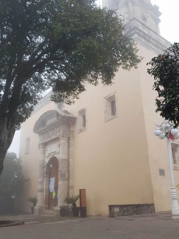
On General Alfonso Corona del Rosal at Calle Columbia Rivera, on the right when traveling north on General Alfonso Corona del Rosal.
Iglesia de la Purísima Concepción
Fue construida a mediados del siglo XVII, dedicada a la Virgen del Rosario, posteriormente fue reconstruida en 1821 y esta vez fue dedicada
a la Purísima Concepción, con su respectiva
celebración día 8 de . . . — — Map (db m162664) HM
On General Alfonso Corona del Rosal just north of Calle Gabriel Mancera, on the right when traveling north.
Gabriel Mancera García de Vicente
(1839-1925)
Empresario Minero, Ferroviario, Político y Filántropo, uno de
los más ilustres personajes hidalguenses de fines del siglo XIX y
principios del siglo XX.
Hidalguense nacido el 6 de mayo de . . . — — Map (db m162596) HM
On General Alfonso Corona del Rosal at Calle Columbia Rivera, on the right when traveling north on General Alfonso Corona del Rosal.
Para beneficio de este pueblo, el gobierno del estado adquirió la linea de electrificación, siendo gobernador constitucional del estado el C. Lic.V Gral.
Alfonso Corona del Rosal inaugurandose en esta fecha.
Mineral del Chico, . . . — — Map (db m162665) HM
On Calle Gabriel Mancera at General Alfonso Corona del Rosal, on the left when traveling east on Calle Gabriel Mancera.
Paisano, detente y admira este árbol que planto la eximia poetisa chilena Gabriela Mistral en 1924 cuando nos distinguio con su presencia Mineral del Chico, Hgo. 1999 Alianza para el Desarrollo H. Ayuntamiento Mineral del . . . — — Map (db m162548) HM
On General Alfonso Corona del Rosal, on the right when traveling north.
Maquinaria del Reloj En la época del auge minero,
a fines del siglo XIX el empresario Hidalguense Gabriel Mancera junto con la cooperación
de los mineros edificaron el anexo a la Iglesia en donde albergarían el reloj.
Este reloj . . . — — Map (db m162600) HM
[Front (South-Side) of Monument]
Erected by
Halleck Post
No. 19
G.A.R. & W.R.C.
In Memory of
Our Comrades
1861 – 1865
[Left (West-Side)]
In Honor of
The Brave Men
Who
From the First
Bore a . . . — — Map (db m29659) HM
In 1888, the State Board of Forestry established an experimental forestry station and nursery, a companion to the Santa Monica Station established in 1887. The two were the first such stations in the nation. Exotic and native trees were tested and . . . — — Map (db m100602) HM
In Memory of Our
Honored Dead of
The World War
1917 – 1918
William H. Aitken • Wyatt L. Arbuckle • Edwin W. Boggs • Russell C. Doyle • Harry A. Elliott • Elbert P. Esmond • Edward N. Fairo • Nelson Coe • Aaron S. Harris • . . . — — Map (db m29758) HM
The massive and majestic Hooker Oak, which occupied this site, was named in honor of renowned British Botanist Sir Joseph Dalton Hooker. The Hooker Oak was acclaimed to be the largest Valley Oak in the world before it fell on May 1, 1977.
Age . . . — — Map (db m100595) HM
A vast expanse covering 26,000 acres, Rancho Chico was purchased in 1849-50 by John Bidwell. In 1865 he began construction of the mansion nearby, which in time became the social and cultural center of the upper Sacramento Valley. It was through his . . . — — Map (db m230785) HM
Near South Pace Boulevard, 0.1 miles south of Cypress Street when traveling south.
Bartram wrote of the security and extent of intracoastal water ways from Virginia's Chesapeake Bay to the Mississippi, in 1774. — — Map (db m110475) HM
On South 6th Street at Grove Street, on the right when traveling south on South 6th Street.
“One of the fine new buildings in Boise,” heralded the Idaho Statesman newspaper in 1935, when the Belaustegui Hotel & Basque Boarding House was constructed by Augustin and Petra Belaustegui. A few years later, part of the hotel . . . — — Map (db m119188) HM
On Deer Creek Highway (California Route 32) at 14 Mile House Drive on Deer Creek Highway.
In June, 1864, the Chico and Humboldt Wagon Road Company began to construct a road to connect Chico with the Idaho mines. A toll station for the Chico and Humboldt Wagon Road stood nearby to the left.
A Georgian, Nick Spires, is said to have . . . — — Map (db m61766) HM
On Skyway Road near Holly Street, on the left when traveling south.
Born June 5, 1884, Santa Ana, California; Died July 15, 1913, Chico, California
Inspired by accounts of the first public flights of Wilber and Orville Wright, Chico resident Thaddeus Kerns constructed and flew a hang glider of his own . . . — — Map (db m92281) HM
On Calle Gabriel Mancera, on the left when traveling east.
Peñas Las Monjas
(Sitio de interés geológico y paisajístico)
Municipio: Mineral del Chico
Coordenadas: 20o12'35"N; 98o 45'20"W
Altitud: 2,997 metros sobre el nivel del mar
Las Peñas de Las Monjas son un . . . — — Map (db m162549) HM
On Calle de la Magdalena, on the right when traveling east.
En este lugar estuvo de 1843 a 1888 el TEATRO VARIEDADES escenario del Género Chico y de los “Bufos Madrileños”
(English translation:)
In this place was from 1843 to 1888 the Teatro Variedades scene of the . . . — — Map (db m212212) HM
Imagine! Right where you are standing one of the world's longest interurban electric railroads called the Sacramento Northern Railway once ran. Along 185 miles of track, it operated between Oakland and Chico from 1912 to 1957. Service on this line . . . — — Map (db m153763) HM
Near Old Skyway Road near Old Depot Road. Reported missing.
In 1902, Diamond Match Co., established the Butte Co. Railroad. The So PAC tracks ran between Chico, Durham, and Stirling City. Regular train service between Chico and Magalia began Nov. 2, 1903. Magalia depot was completed soon thereafter. April 8, . . . — — Map (db m61223) HM
John Bidwell was born on the east coast to a poor farming family in 1819. In spite of these modest roots, he would eventually become a key figure in California history, one famous for being a true pioneer, a statesman, politician, prohibitionist, . . . — — Map (db m29637) HM
Completed in 1868, the home featured many surprisingly modern conveniences including running water, flush toilets, an acetylene gas lighting system, eight fireplaces, and wall-to-wall carpeting. The pink stucco mansion was designed by San Francisco . . . — — Map (db m29644) HM
On East Shore Highway (California Route 147), on the left when traveling north.
The Hamilton Dairy opened in Big Meadows in 1860. In 1910 Canyon Dam was built, then filled in 1914, creating Lake Almanor. This milkhouse was then moved here out of the meadows above lake level. The Hamilton and Holmes families used the milk to . . . — — Map (db m66080) HM
On Road 82 at milepost 35, on the right when traveling east.
In this immediate vicinity, Captain Henry W. Stanton of the U.S. Army, for whom Fort Stanton was named, lost his life in 1855 in a skirmish with the Mescalero Apaches. For several weeks, soldiers commanded by Stanton and Capt. Richard S. Ewell, were . . . — — Map (db m73434) HM
On Main Street at Arcadia Street, on the right when traveling north on Main Street.
Land, Luxury and the Last Mexican Governor
When Pio Pico, California's last Mexican governor, erected the city's most elegant hotel in 1870, its indoor plumbing, dramatic gas lighting and French restaurant suited the social and . . . — — Map (db m227921) HM
Near K Street at Interstate 5, on the right when traveling east.
While a few people question Sacramento’s role in the transcontinental railroad, the larger story of Sacramento’s place in transportation history revolves around numerous transportation events such as national stagecoach lines, steamship companies, . . . — — Map (db m229917) HM
Another distinctive era in the demographic history of the southern waterfront occurred when the construction of several interurban railroad lines along Front Street revitalized the area. In the first decade of the 20th century, several interurban . . . — — Map (db m16544) HM
On State Highway 1, on the right when traveling east.
Settled by Indians,"Isle of the Chitamachas" was later owned by Francisco Caminada. Known as "Chico Isle", as "Chita", as Caminadaville. It was home to pirates, fishermen and farmers. On Oct. 1, 1893, a fast moving, late season hurricane from the . . . — — Map (db m62038) HM
On Feather River Boulevard, on the right when traveling south.
Thousands of Jewish emigrants escaping religious persecution and economic oppression in Germany and Eastern Europe joined the Gold Rush to California.
They brought with them a strong work ethic and religious conviction. These settlers were . . . — — Map (db m61497) HM
On Black Olive Drive north of Pearson Road, on the right when traveling north.
Constructed in 1903, this depot is one of three maintained along the Butte County Railroad, a 31 mile line from Chico to Stirling City, completed by Diamond Match Co. in 1904. The railroad was later acquired by Southern Pacific and operated as a . . . — — Map (db m29671) HM
This peaceful community, gateway to the remote regions of the High Lakes of Butte and Plumas Counties, owes its origin and subsequent development to the entrance of the Diamond Match Company to California. With the purchase of about 40,000 acres of . . . — — Map (db m61764) HM
Near Western Pacific Way, 0.2 miles west of Main Street.
The Sacramento Northern was a subsidiary railroad of the Western Pacific. The SN was originally an electric interurban railroad from Oakland to Chico, California, but by the late 1960s it was dieselized and its lines had been chopped into isolated . . . — — Map (db m163297) HM
On South Barracks Street at East Main Street, on the left when traveling south on South Barracks Street.
During the mid-1800s, 16 wharves reached into Pensacola Bay, along a three-mile stretch of waterfront from Bayou Texar to Bayou Chico. A few years later, around 1900, railroad companies invested in Pensacola's port facilities, improving wharves and . . . — — Map (db m91137) HM
On South King Drive, on the right when traveling south.
The Marx Brothers
Comedy team
The Marx Brothers lived here at 4512 Grand Boulevard
(now King Drive) when they moved to Chicago to tour the
vaudeville circuit in the 1910s. Their act, “The Six Musical
Mascots,” included all five . . . — — Map (db m181366) HM
On North Palafox Street at Wright Street, in the median on North Palafox Street.
As the Spanish Governor of Louisiana Territories, Bernardo de Gálvez was an important friend of American Colonists. When Spain became an ally of the American Revolutionaries in 1779, Bernardo de Gálvez led a multinational force of troops from New . . . — — Map (db m145510) HM
In the spring of 1846 pioneers settling in the western valleys of Oregon encouraged the opening of an alternate wagon route from the states to their settlements—one that avoided the perils of the Columbia River, and one free of control by . . . — — Map (db m128076) HM
On North Trinity Street (Farm to Market Road 730), on the right when traveling south.
A leading public man in Texas, 1896-1939. Born in Wise County to early (1854) settlers. After two years at Texas A. & M., read law and began practice in 1886. Served 1888-92 as Decatur City Attorney; 1892-96 as County Attorney; 1896-1901 and . . . — — Map (db m108521) HM
On Avenida Benito Juárez at De Sopena, on the left when traveling west on Avenida Benito Juárez.
Plaza de la Paz
La plaza de la Paz es un cruce obligado para quiénes
transitan esta ciudad.
En siglos pasados esta fue conocida como la "Plaza Mayor"
y en los documentos más antiguos de Guanajuato el
mencionaron cómo un punto . . . — — Map (db m199197) HM
On Centerville Road north of North Humbug Road, on the right when traveling north.
Erected in 1894 by C.H. Hintz this building was used continuously for school purposes until 1966 when due to unification, pupils were bussed into Chico. The first teacher was Miss Ada Woods. Cost of building was $600.Purchased by Centerville . . . — — Map (db m29692) HM
On this site was the Moraga Train Station of the
Sacramento Northern Railway, a 183-mile railway
that connected Oakland and Chico via Sacramento,
handling passengers and freight.
The station served Moraga Valley from 1913 to 1957. . . . — — Map (db m184241) HM
On Joliet Road west of South LaGrange Road (U.S. 45), on the right when traveling north.
Early travelers on Route 66 raced through open lands once they left Chicago. This was truly “countryside,” a rich region of farms and quarries on the outskirts of the city. Few farms remained by the time the City of Countryside was . . . — — Map (db m157673) HM
On Cesar Chavez Lane, 2.6 miles west of U.S. 99, on the right.
The Forty Acres has been designated a
National Historic Landmark.
This property possesses national significance
in commemorating the history of the
United States of America.
Forty Acres embodies and conveys multiple layers of national . . . — — Map (db m54836) HM
Near Parking Lot BIA 100 MP 0 (Route 100 Connector Road) 0.8 miles east of Route 12 N (Arizona Highway 263).
In Remembrance of Our Warriors
Who Made the Ultimate Sacrifice and/or
Missing in Action,
They will never be forgotten
and to us they will always be young in our thoughts.
Nelson Lewis • Walter Nelson • Willie A. Notah • Edie . . . — — Map (db m27911) HM
On Calle Río Lerma just north of Calle Revolución, on the left when traveling north.
ValtierrillaEste poblado es el principal de las comunidades del municipio de Salamanca. Tiene su origen desde la época prehispánica, como asentamiento de la tribu otomí. Pasa al dominio español durante la conquista en los albores el . . . — — Map (db m115282) HM
On Calle de la Revolución just east of Calle Juan de la Barrera, on the left when traveling east.
ValtierrillaEste poblado es el principal de las comunidades del municipio de Salamanca. Tiene su origen desde la época prehispánica, como asentamiento de la tribu otomí. Pasa al dominio español durante la conquista en los albores el . . . — — Map (db m117346) HM
On Friendship Street north of Alumni Drive, on the left when traveling north.
Country singer and songwriter Chris Young is a Grammy- and Academy of Country Music-nominated vocalist. His style is rooted in traditional country music, although he performs with a contemporary sensibility.
Christopher Alan Young, born in . . . — — Map (db m166467) HM
On Grand Avenue at Harrison Street on Grand Avenue.
In memory of
8th California Volunteer Infantry
Regiment
Eight Army Corps
Mustered in at Camp Barrett Oakland, California
July 6, 1898
Companies
A - Chico
B - San Jose
C - Petaluma
D - San Rafael
E - Santa Rosa
F - . . . — — Map (db m157259) WM
It is silent now, but long ago, you would hear the shrill scraping
of iron wheels along a track as a green Interurban electric train
would suddenly appear and pass along the very path on which
you are standing. From 1912 to 1957, the popular . . . — — Map (db m184320) HM
Freight railroads serviced the Moraga Rancho from 1889 to 1957.
Passenger service to the Moraga Station began in 1913.
Commuters, high school and St. Mary's College students rode
the train in the early days, as well as picnickers going . . . — — Map (db m152671) HM
On North Boyle Avenue at 1st Street, on the left when traveling north on North Boyle Avenue.
Cummings Comes To California
The stately brick building, with its projecting turret and other distinctive Victorian-era details, is one of the reminders of early Boyle Heights; and the Cummings Block, completed in 1889, represents . . . — — Map (db m174709) HM
Begun in 1933 in the depths of the Depression, the San Francisco-Oakland Bay Bridge put hundreds of men to work on two six-hour shifts, morning and night, for three years and seven months, to finish two months ahead of schedule on November 12, . . . — — Map (db m92904) HM
On State Street (State Highway 17) at Court Avenue, on the left when traveling south on State Street.
Dedicated to the Men and Women of Jeff Davis County Who Have Served Their Country to Protect Our Freedom
Frank P. Adams • Harvey Adams • Scott Adams • Anton Aggerman • Robert A. Aggerman • Robert M. Aggerman • Don Agold • Adan Aguilar • . . . — — Map (db m218538) WM
Shortly after Arkansas was admitted to the Union in 1836, the Federal government established the Little Rock Arsenal for the storage of munitions and weapons in defense of the frontier. Eventually, more than thirty buildings were constructed on . . . — — Map (db m117241) HM
Near Evergreen Street, on the right when traveling south.
James Williams
California Pioneer
James Williams, age 29 and a native of Cape Girardeau, Missouri, emigrated overland to California in 1843 along with his three brothers – John, age 25; Isaac, age 20; and Squire, age 19 – in a . . . — — Map (db m62440) HM
Near North 3rd Street, 0.1 miles north of East Indian School Road.
Killed in Action
Lee Rainbow * Wallace Antone
Honor Roll:
Charles Laws • Isaac Jese • Oliver Sneed •
Wm. T. Moore •
Joe McCarthy •
Peter Moore •
Charles Gougn •
Seth Oldman •
Harvier Adams •
George Bell •
Roy Left Hand • . . . — — Map (db m27252) WM
This memorial is dedicated to honor those special aviators who lost their lives during the Southeast Asia war while serving as Forward Air Controllers (FACs) in the 0-1, 0-2, OV-10, U-10, U-17, PC-6 and T-28 aircraft.
From 1962 through the . . . — — Map (db m100420) HM WM
* Inflectional forms of words are their plurals, singulars, and possessives as well as gramatical tenses and similar variations.