67 entries match your criteria.
Entries Containing All of the Words «portsmouth» AND «va»
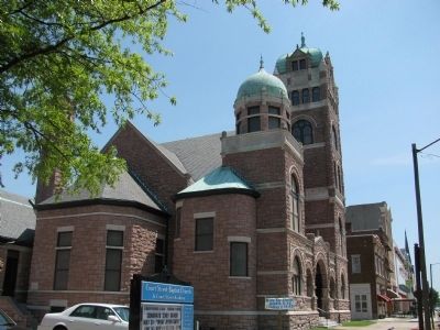
By Scott Rollins, June 1, 2009
Court Street Baptist Church
RANKED BY RELEVANCE, THEN GEOGRAPHICALLY
| 1 ► Virginia, Portsmouth, Olde Towne — Court Street Baptist Church — Path of History, Portsmouth, VA — |
| On Court Street south of London Street, on the right when traveling north. | |||
| 2 ► Virginia, Portsmouth, Olde Towne — Towne Square — Path of History, Portsmouth, VA — |
| On High Street east of Court Street, on the right when traveling west. | |||
| 3 ► Virginia, Portsmouth, Westbury — The Historic Portsmouth Community Library — Path of History, Portsmouth, VA — |
| On Elm Avennue (Virginia Route 337) at Rutter Street, on the right when traveling south on Elm Avennue. | |||
| 4 ► Virginia, Portsmouth, Hope Village — Norfolk Naval Shipyard — “The Beginning” — Path of History Portsmouth, VA — |
| Near Lincoln Street east of 3rd Street, on the left when traveling east. | |||
| 5 ► Virginia, Portsmouth, Hope Village — Norfolk Naval Shipyard — “1774-1800” — Path of History Portsmouth, VA — |
| Near Lincoln Street east of 3rd Street, on the left when traveling east. | |||
| 6 ► Virginia, Portsmouth, Hope Village — Norfolk Naval Shipyard — “Hammerhead Crane” — Path of History Portsmouth, VA — |
| Near Lincoln Street east of 3rd Street, on the left when traveling east. | |||
| 7 ► Virginia, Portsmouth, Hope Village — Norfolk Naval Shipyard — “Dry Docks Construction” — Path of History Portsmouth, VA — |
| Near Lincoln Street east of 3rd Street, on the left when traveling east. | |||
| 8 ► Virginia, Portsmouth, Hope Village — Norfolk Naval Shipyard — “1889-1904” — Path of History Portsmouth, VA — |
| Near Lincoln Street east of 3rd Street, on the left when traveling east. | |||
| 9 ► Virginia, Portsmouth, Hope Village — Norfolk Naval Shipyard — “World War I” — Path of History Portsmouth, VA — |
| Near Lincoln Street east of 3rd Street, on the left when traveling east. | |||
| 10 ► Virginia, Portsmouth, Hope Village — Norfolk Naval Shipyard — “World War II” — Path of History Portsmouth, VA — |
| Near Lincoln Street east of 3rd Street, on the left when traveling east. | |||
| 11 ► Virginia, Portsmouth, Hope Village — Norfolk Naval Shipyard — “Korea - 1965” — Path of History Portsmouth, VA — |
| Near Lincoln Street east of 3rd Street, on the left when traveling east. | |||
| 12 ► Virginia, Portsmouth, Hope Village — Norfolk Naval Shipyard — “1907-1922” — Path of History Portsmouth, VA — |
| Near Lincoln Street east of 3rd Street, on the left when traveling east. | |||
| 13 ► Virginia, Portsmouth, Hope Village — Norfolk Naval Shipyard — “Dry Dock 1” — Path of History Portsmouth, VA — |
| Near Lincoln Street east of 3rd Street, on the left when traveling east. | |||
| 14 ► Virginia, Portsmouth, Hope Village — Norfolk Naval Shipyard — “1833-1862” — Path of History Portsmouth, VA — |
| Near Lincoln Street east of 3rd Street, on the left when traveling east. | |||
| 15 ► Virginia, Portsmouth, Hope Village — Norfolk Naval Shipyard — “1812-1833” — Path of History Portsmouth, VA — |
| Near Lincoln Street east of 3rd Street, on the left when traveling east. | |||
| 16 ► Virginia, Portsmouth, Hope Village — Norfolk Naval Shipyard — “Quarters A” — Path of History Portsmouth, VA — |
| Near Lincoln Street east of 3rd Street, on the left when traveling east. | |||
| 17 ► Virginia, Portsmouth, Hope Village — Sail portion of the USS Thomas Jefferson — (SSBN 618) later SSN 618 — Path of History Portsmouth, VA — |
| Near Lincoln Street east of 3rd Street, on the left when traveling east. | |||
| 18 ► Virginia, Portsmouth, Olde Towne — Chevra T'helim Synagogue — |
| On Effingham Street (Virginia Route 141), on the right when traveling north. | |||
| 19 ► Virginia, Portsmouth, Olde Towne — Lincolnsville — |
| On North Street, on the right when traveling east. | |||
| 20 ► Virginia, Portsmouth, Olde Towne — The 1846 Courthouse — Path of History — Portsmouth, VA — |
| On Court Street north of High Street, on the right when traveling south. | |||
| 21 ► Virginia, Portsmouth, Olde Towne — The Yellow Fever of 1855 — |
| On North Street at Dinwiddie Street, on the right when traveling east on North Street. | |||
| 22 ► Virginia, Portsmouth, Park View — Cedar Grove Cemetery — |
| On Fort Lane at Blair Street, on the right when traveling north on Fort Lane. | |||
| 23 ► Virginia, Portsmouth, Swimming Point — Portsmouth Naval Hospital — "Naval Medical Center Portsmouth" — Fort Nelson Park • Path of History • Portsmouth, VA — |
| Near Effingham Street at Williamson Drive, on the right when traveling north. | |||
| 24 ► Virginia, Portsmouth, Swimming Point — Portsmouth Naval Hospital — "Charette Health Care Center 1999" — Fort Nelson Park • Path of History • Portsmouth, VA — |
| Near Effingham Street at Williamson Drive, on the right when traveling north. | |||
| 25 ► Virginia, Portsmouth, Swimming Point — Portsmouth Naval Hospital — “Civil War 1861-1865” — Fort Nelson Park — |
| Near Effingham Street at Crawford Parkway, on the right when traveling north. | |||
| 26 ► Virginia, Portsmouth, Swimming Point — Portsmouth Naval Hospital — “Spanish-American War 1898” — Fort Nelson Park — |
| Near Effingham Street at Crawford Parkway, on the right when traveling north. | |||
| 27 ► Virginia, Portsmouth, Swimming Point — Portsmouth Naval Hospital — “World War II and Korea 1937-1953” — Fort Nelson Park — |
| Near Effingham Street at Crawford Parkway, on the right when traveling north. | |||
| 28 ► Virginia, Portsmouth, Swimming Point — Portsmouth Naval Hospital — “Hospital Renovation 1907-1910” — Fort Nelson Park — |
| Near Effingham Street at Crawford Parkway, on the right when traveling north. | |||
| 29 ► Virginia, Portsmouth, Swimming Point — Portsmouth Naval Hospital — “Building 215, Portsmouth’s First Skyscraper 1960” — Fort Nelson Park — |
| Near Effingham Street at Crawford Parkway, on the right when traveling north. | |||
| 30 ► Virginia, Portsmouth, Swimming Point — Portsmouth Naval Hospital — “The Navy’s First Corps School 1902” — Fort Nelson Park — |
| Near Effingham Street at Crawford Parkway, on the right when traveling north. | |||
| 31 ► Virginia, Portsmouth, Swimming Point — Portsmouth Naval Hospital — “Yellow Fever Epidemic” — Fort Nelson Park — |
| Near Effingham Street at Crawford Parkway, on the right when traveling north. | |||
| 32 ► Virginia, Portsmouth, Swimming Point — Portsmouth Naval Hospital — “Naval Burial Ground 1838” — Fort Nelson Park — |
| Near Crawford Parkway at Effingham Street. | |||
| 33 ► Virginia, Portsmouth, Swimming Point — Portsmouth Naval Hospital — “The U.S. Navy’s First Hospital” — Fort Nelson Park — |
| Near Effingham Street at Crawford Parkway, on the right when traveling north. | |||
| 34 ► Virginia, Portsmouth, Swimming Point — Portsmouth Naval Hospital — “Hospital Point” — Fort Nelson Park — |
| Near Effingham Street at Crawford Parkway, on the right when traveling north. | |||
| 35 ► Virginia, Portsmouth, Swimming Point — Portsmouth Naval Hospital — “Hospital Fund” — Fort Nelson Park — |
| Near Effingham Street at Crawford Parkway, on the right when traveling north. | |||
| 36 ► Virginia, Portsmouth, Swimming Point — Portsmouth Naval Hospital — “Early Naval Medicine” — Fort Nelson Park — |
| Near Effingham Street at Crawford Parkway, on the right when traveling north. | |||
| 37 ► Virginia, Portsmouth, Swimming Point — Portsmouth Naval Hospital — “Navy Nurse Corps 1908” — Fort Nelson Park — |
| Near Effingham Street at Crawford Parkway, on the right when traveling north. | |||
| 38 ► Virginia, Portsmouth, Swimming Point — Portsmouth Naval Hospital — “World War I 1917-1918” — Fort Nelson Park — |
| Near Effingham Street at Crawford Parkway, on the right when traveling north. | |||
| 39 ► Virginia, Portsmouth, Olde Towne — Lightship Portsmouth — 101-WAL524 — |
| On Water Street at London Street, on the right when traveling north on Water Street. | |||
| 40 ► Virginia, Portsmouth, Olde Towne — Lightship Portsmouth — 101-WAL524 — |
| On Water Street at London Street, on the right when traveling north on Water Street. | |||
| 41 ► Virginia, Portsmouth, Olde Towne — Seaboard Air Line Railroad — |
| Near Water Street at High Street, on the right when traveling north. | |||
| 42 ► Virginia, Portsmouth, Olde Towne — The Coast Guard — |
| On Water Street at London Street, on the left when traveling south on Water Street. | |||
| 43 ► North Carolina, Mecklenburg County, Charlotte, Charlotte center city — L-56 — Confederate Navy Yard — |
| On E. Trade Street, 0.2 miles east of Tryon Street, on the right when traveling west. | |||
| 44 ► New York, Delaware County, Sidney — Sheldon Hobert Barnes, MD — |
| On River Street at New York State Route 8, on the left when traveling east on River Street. | |||
| 45 ► Connecticut, New Haven County, Meriden — Meriden Soldiers Memorial — |
| On East Main Street at Catlin Street, on the right when traveling west on East Main Street. | |||
| 46 ► New York, Delaware County, Sidney — Ralph Elwin Rice — |
| On River Street at New York State Route 8, on the left when traveling east on River Street. | |||
| 47 ► North Carolina, New Hanover County, Wilmington, Historic District — Vollers-Hardin-Walker House — 1896 — |
| On South 4th Street at Dock Street, on the right when traveling south on South 4th Street. | |||
| 48 ► Maryland, Frederick County, Burkittsville — Chew’s Ashby Artillery — |
| On Gapland Road, on the right when traveling south. | |||
| 49 ► Maryland, Frederick County, Burkittsville — The Stage is Set — |
| On Gapland Raod near Arnoldstown Road, on the left when traveling west. | |||
| 50 ► Virginia, Virginia Beach, Princess Anne — KV 32 — Sgt. Miles James — (ca. 1829-ca. 1871) — |
| On Princess Anne Road (Virginia Route 165) west of North Landing Road, on the right when traveling east. | |||
| 51 ► Maryland, Frederick County, Burkittsville — C.P. 5 — Confederate Forces — Munford’s Brigade and Mahone’s Brigade — |
| On Gapland Road / West Main Street at Mountain Church Road, on the right when traveling west on Gapland Road / West Main Street. | |||
| 52 ► Maryland, Frederick County, Burkittsville — C.P. 3 — Crampton’s Pass Tablet C.P. 3 — |
| On Gapland Road at Arnoldstown Road, on the right when traveling west on Gapland Road. | |||
| 53 ► Maryland, Frederick County, Burkittsville — “Sealed With Their Lives” — |
| On Gapland Road, on the right when traveling south. | |||
| 54 ► Maryland, Frederick County, Burkittsville — Brownsville Pass: Semmes’ Gamble — |
| On Gapland Road at Arnoldstown Road, on the left when traveling west on Gapland Road. | |||
| 55 ► Virginia, Amelia County, Amelia Court House — Pvt James Milton Parrish — |
| Near Pridesville Road (Virginia Route 681) 1.1 miles north of Amelia Avenue (Virginia Route 656), on the left when traveling north. | |||
| 56 ► Maryland, Frederick County, Burkittsville — Bartlett Leads the Way — |
| On Gapland Raod at Arnoldstown Road, on the left when traveling west on Gapland Raod. | |||
| 57 ► Virginia, James City County, Jamestown — Remembering Ancestors — |
| Near Colonial Parkway, 1.2 miles east of Jamestown Road (Virginia Route 31), on the right when traveling west. | |||
| 58 ► Virginia, Suffolk — Civil War Militia of Suffolk and Nansemond County — |
| Near Mahan Street east of North Main Street (Virginia Route 32). | |||
| 59 ► New York, Ontario County, Bloomfield — East Bloomfield to the Memory of her Sons — |
| On South Avenue at State Street (New York State Route 5), on the right when traveling south on South Avenue. | |||
| 60 ► Virginia, Poquoson — Veterans Memorial — |
| On City Hall Avenue, 0.1 miles south of Victory Boulevard (Virginia Route 171), in the median. | |||
| 61 ► Virginia, Norfolk, Fort Norfolk — Historical Points of Interest — |
| Near Riverview Avenue at Southampton Avenue, on the left when traveling west. | |||
| 62 ► Virginia, Portsmouth, Olde Towne — Virginia Ship Repair Association — |
| Near Water Street, 0.1 miles east of Bill Deal Street. | |||
| 63 ► West Virginia, Kanawha County, Standard — Mary Ingles — Captive Journey! — America’s Byways — Paint Creek Scenic Trail — |
| On Paint Creek Road (Local Route 83) at Exit 74 (Interstate 77) on Paint Creek Road. | |||
| 64 ► West Virginia, Raleigh County, Beckley — The Indian Path — |
| 65 ► Pennsylvania, Blair County, Altoona — Soldiers' and Sailors' Monument — Fairview Cemetery — |
| Near 18th Avenue at 8th Street, on the left when traveling south. | |||
| 66 ► Rhode Island, Washington County, Narragansett, Point Judith — The S.S. Black Point — |
| On Ocean Road. | |||
| 67 ► Delaware, New Castle County, Wilmington, Brandywine Park — African American Medal of Honor Recipients Memorial — |
| On West 18th Street at Baynard Boulevard on West 18th Street. | |||
* Inflectional forms of words are their plurals, singulars, and possessives as well as gramatical tenses and similar variations.