"He burned the House of the Lord, the king's palace, and all the houses of Jerusalem; he burned down the house of every notable person." (II Kings 25: 9)
This residential quarter went up in flames with the rest of . . . — — Map (db m63933) HM
Then delivered he him therefore unto them to be crucified
and they took Jesus, and led him away.
And he bearing the cross went forth into a place called Golgatha
where they crucified him and two other with him, on either
side one, and Jesus in . . . — — Map (db m95071) HM
The Ottoman Sultan Suleiman the Magnificent appointed Sheikh Ahmad Al-Dajani as the guardian of Nabi Daud Tomb (King David). For 400 years, the family have been responsible for the tomb and its surroundings. Many family members are buried in the . . . — — Map (db m220110) HM
The enigma of QORBAN
The lintel placed above the door of the store was discovered on September 18, 1890. He was found near a large silo, in 1892 became burial vault.
The measure of the lintel is: 2.40 m long; Its height: 40 cm and its . . . — — Map (db m220200) HM
Here Dwells Ahiel in a Four Room House
"He (David) had houses made for himself in the City of David..." (1 Chronicles15: 1)
The name 'Ahiel' appears on potsherds found among the ruins of this house. The House . . . — — Map (db m65296) HM
"And Hiram king of Tyre sent messengers to David, and cedar - trees, and carpenters, and masons; and they built David a house" (II Samuel 5: 11)
Excavations in progress at this site since May 2005 conducted by Eilat Mazar, . . . — — Map (db m64064) HM
At the end of War of Independence (1948) access to Mount Zion became dangerous due to Jordanian sniper fire directed at the area. In order to ensure the smooth passage of troops, supplies and equipment, a trench was dug from the neighborhood of . . . — — Map (db m219055) HM
"The other events of Hezekiah's reign, and all his exploits, and all his exploits, and how he made the pool and the conduit and brought the water into the city, are recorded in the Annals of the Kings of Judah" (II Kings 20:20) . . . — — Map (db m63905) HM
English Text:
Two smaller silver objets were discovered in the bone repository, rolled up like tiny scrolls, to be worn as amulets. After the scrolls were unrolled, it emerged that they were made of pure silver, measured 27 x 97 . . . — — Map (db m141591) HM
"...the city shall be rebuilt on its mound, and the fortress in its proper place" (Jeremiah 30:18)
The inhabitants of ancient Jerusalem once built their homes on this hillside. The earliest structure unearthed here . . . — — Map (db m63928) HM
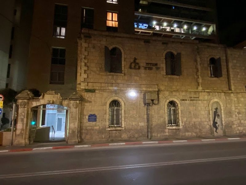
Built in 1906 for the elders of Jerusalem as a magnificent courtyard building on the main Jaffa Road, with stone details and a wide external staircase leading to the building's entrance. Evacuated in the 1970s, in 2014 the building underwent a . . . — — Map (db m220102) HM
The Shrine of the Book is home to the Dead Sea Scrolls, among them, the world's oldest copies of biblical books. It is also home to rare biblical manuscripts from later periods, such as the Aleppo Codex. Besides the two-thousand year old scrolls, . . . — — Map (db m199103) HM
"And David said on that day: 'Whosoever smiteth the Jebusites, and getteth up to the gutter...'" (II Samuel 5:8)
We are standing at the entrance to a subterranean water system. The Gihon Spring was Jerusalem's . . . — — Map (db m63947) HM
This vault was built in 1892 in an old silo of 8m. long, 10m. wide, and 5m. high. Here, are waiting for the resurrection, 24 pilgrims, 25 nuns, and 24 Assumptionists.
Ce caveau a été aménagé en 1892 dans un ancien
silo . . . — — Map (db m220189) HM
English Text:
Seven burial caves from the late First Temple period were found at the site. The caves, which were hewn into the cliff above which the Scottish Church of St. Andrew was built, were found partially destroyed by later . . . — — Map (db m141978) HM
They were founded in Nimes, France, by Fr. Emmanuel d'Alzon (1810-1880)
The Assumptionist Fathers, in 1845
They are present in thirty countries around the world, where they devote themselves to teaching, social and . . . — — Map (db m220194) HM
The Divine presence never moves from the Western Wall.
Jewish tradition teaches that the Temple Mount is the focal point of Creation. In the center of the mountain lies the “Foundation Stone” of the world. Here Adam came . . . — — Map (db m44722) HM
Two ancient synagogues reside in this complex. Ha-Ari Synagogue, by tradition the birthplace in 1534 of Kabbalist Ha-Ari Ha-Kadosh, and Or Ha-Haim Synagogue, which is named for Rabbi Haim ben-Atar of Morocco, who founded Knesset Yisrael Yeshiva here . . . — — Map (db m220142) HM
Remains of a magnificent main road from the Roman-Byzantine period serving throughout time until today as a major thoroughfare for shopping. — — Map (db m220140) HM
Built in the time of Sultan Suleiman the Magnificent in the 16th century. In Arabic: Bab al-Nabi Daoud, due to its proximity to King David's Tomb.
(Hebrew and Arabic text not transcribed) — — Map (db m219060) HM
This typical Jerusalem courtyard building, with three wings, was erected in 1895 by Solomon Feingold. In 1908 it housed the city's first movie theater. In the early British Mandate period the offices of "Do-Ar Hayom" newspaper were located here, as . . . — — Map (db m220089) HM
This trade and business building was designed by Italian architect Marcello Piacentini in 1934 in a combined classic and international style. The façades of the shops on the ground floor are convex built of coarse stone. The building outline . . . — — Map (db m220086) HM
During the British Mandate period, this was the site of the clinic of the orthopaedic surgeon Dr. Treu. On June 7, 1946, Dr. Yisrael Sheib "Eldad", one of the Lehi leaders imprisoned in the Latrun detention camp, was brought here for treatment. A . . . — — Map (db m220171) HM
Pediatrician Helena Kagan (1889-1978) founded pediatrics in Jerusalem, including mother and child care clinics and day-care centers for Jews and Arabs alike. Active in the Jewish women organization that joined later WIZO. Israel PrizeLauriate, 1975. . . . — — Map (db m220156) HM
Designed by architect Re'uven Trostler and built in 1996 for the Israeli Medical Association, a three-floor building with a rounded entrance. Jerusalem municipality bought the building and turned it to a cultural center.
(Hebrew and Arabic . . . — — Map (db m220151) HM
Built in 1882 by the architect and archaeologist Conrad Schick for his family. The central building is typical to rich Palestinian homes of the time, with thick stone walls, niches and vaulted ceilings, with archaeological items attached to the . . . — — Map (db m220163) HM
The Syrian-Orthodox community built this house in 1868 and leased it in 1895 to the US Consulate, that moved to what was known at the time the street of the consulates. Changes they made included the removal of the tile-roof and opening the ground . . . — — Map (db m220173) HM
Military leader and Israeli Government Minister. Was born in the capital of Israel, Jerusalem.
From early on in life, he defended his people like the emblematic two sheaves of wheat and a sword, a symbol which has accompanied generations of . . . — — Map (db m220147) HM
Typical Jewish neighborhood, founded in 1875, the row houses are built around a square courtyard in the center of which are cisterns. The neighborhood, which has two entry gates, was intended for Ashkenazim and Sephardim, and each community had . . . — — Map (db m220098) HM
A courtyard neighborhood built In 1911 by the Bukharan Jew Yitzhak Saidoff, in 1911. In the common style at the time of a two-story building and a backyard with two water pits. Shops housed the first floor while flats in the second floor with an . . . — — Map (db m220099) HM
Shaare Zedek Hospital was named after its founder Dr. Moshe Wallach, who was born in 1866 in Germany and immigrated to the land of Israel in 1891. The hospital was built thanks to his initiative, am perseverance, and the donations of German and' . . . — — Map (db m220100) HM
Mameluke mosque, formerly a place of prayer and residence for Sufi Dervishes, named after its founder, Salah al-Din (Saladin). During 1099-1187 the Patriarch's palace was in this site. — — Map (db m219019) HM
An arch decorated with "pillows" which demarcated the opening of the Western entrance into the Church of the Holy Sepulchre in the Crusaders period.
(Hebrew and Arabic not transcribed) — — Map (db m222064) HM
One of the most beautiful and important gates within the Ottoman City walls, dating from the 16th century. The Gate led to Jaffa and to Hebron, and hence the origin of its name (in Arabic Bab al-Khalil-Hebron Gate).
(Hebrew and Arabic text . . . — — Map (db m219032) HM
The paving stones in this section are part of the street pavement dating from the end of the Roman Period, 3rd-4th century C.E.
The street paved with these stones was discovered underneath the existing level in the course of development works . . . — — Map (db m222065) HM
A public water fountain built in the 16th century, also named in Arabic: "Sebil Sit Mariam", due to its proximity to the place where Virgin Mary was born according to Christian tradition.
(Hebrew and Arabic texts not transcribed) — — Map (db m220236) HM
A Catholic Convent whose construction was completed in 1860. The site contains the remains of a water cistern (Struthion Pool) and the pavement (Lithostrotos) from the Antonio Fortress dating from the second Temple period.
(Hebrew and Arabic . . . — — Map (db m220146) HM
In Memory of Yig'al Shahaf (Masrufi) Hy''d who was murdered at this very spot on 18 (Yud Het) Tishre 5748 11 October, 1987 in a shooting attack
(Hebrew text not transcribed) — — Map (db m219013) HM
The Russian Compound housed the offices of the Palestine Police and the British Criminal Investigation Department (CID). On March 23, 1944, Etzel attacked and blew up the CID section. In the course of the attack, fighter Asher Benziman was killed. . . . — — Map (db m220087) HM
Around the compound was a perimeter wall with two formal gates at north and south. This is one of the two gate houses, built in 1890. The other was pulled down in the 70s. On the facade is the emblem of the "Imperial Russian Orthodox Palestine . . . — — Map (db m220003) HM
On the morning of May 14th 1948, units of the Haganah and the Irgun Zvai Leumi began an operation to take over the positions held by the British, including the central "Russian Compound". The Haganah succeeded in gaining control of all of the . . . — — Map (db m220088) HM
The Roman Catholic Salesian Congregation built in 1928-1938 this two-story tile-roof school. Half of the pupils were of Jewish families who preferred high quality European education for their children. Houses currently the Ministry of Education . . . — — Map (db m219969) HM
Built in 1886-1890, the Sergei compound was named after Prince Sergei, brother of Tsar Alexander III, as a hotel for noble Russian pilgrims. Designed by architect George Franghia as a two-story building of mixed styles. The centered entrance . . . — — Map (db m219993) HM
The Evangelical Lutheran Church of Finland educational and cultural center was until 1968 a boarding school for Jewish children. Serves today mainly as a pilgrim hostel. Built in 1875 with an English-colonial facade, with a red-and-white arcade on . . . — — Map (db m219971) HM
Among the collapsed stones was one (its replica displayed here), which bore a Hebrew inscription: "to the place of trumpeting to...". In the Second Temple days this stone probably marked the place - at the top of the southwest corner of the Temple . . . — — Map (db m219238) HM
During the Roman and Byzantine periods alongside the continued use of local limestone the use of marble in construction became widespread, particularly in public buildings. The display contains architectural elements that decorated public buildings . . . — — Map (db m219114) HM
Sons of the 'Old Yishuv' in Jerusalem typically studied Torah from a young age. Following many years of study, as adult men, they would train to become either a scholar or a professional.
Daughters were destined to be wives and mothers, and . . . — — Map (db m219121) HM
"And Eternal Life He has implanted within us" (blessing on reading the Torah).
This is the original site of Old Jerusalem's largest yeshiva. All age groups - from young children to the elderly - have studied here since 1876.
The yeshiva . . . — — Map (db m220117) HM
On November 29, 1947, the War of Independence broke out and the battle for the Old City of Jerusalem lasted 180 days. The early stages of the war were characterized by localized Arab attacks in full view of the unresponsive British Army. When the . . . — — Map (db m219151) HM
This was one of the most important Sephardic yeshivot in Jerusalem. The cornerstone was laid in 1914. Its grand inauguration took place in 1923.
During the War of Independence (1948), the building served as a frontline position for the besieged . . . — — Map (db m219155) HM
Remains of Jerusalem's main street, running the length of the Western Wall along about one kilometer, in the late Second Temple period. The street was paved with flagstones and edged with curbstones. It had two large drainage channels running . . . — — Map (db m219237) HM
The Order of the Teutonic Knights settled here during the Crusader Period (12th-13th centuries CE). The Order built the Church of St. Mary and a hospital, which were destroyed; and St. Mary's Hospice of the German Knights, whose ruins you see before . . . — — Map (db m220119) HM
Until the sixteenth century, the "Ramban" was the main synagogue, where members of all denominations prayed together. Its closure at the end of that century is probably the point at which the various streams dispersed. The Sephardi Jews organized in . . . — — Map (db m219150) HM
The Crusaders built a roofed market on the remnants of the Byzantine Cardo. In the ensuing years, the vaulted ceilings became the cellars of buildings above. The market was renovated after the Six Day War (1967).
Photo caption: Capital of a . . . — — Map (db m220120) HM
In the mid-19th century, the waves of Jewish immigration increased, and the Ashkenazi community grew rapidly. On September 25, 1864, the great Hurva synagogue was inaugurated in an inspiring ceremony Just in time for the High Holidays. Ceremony . . . — — Map (db m219118) HM
You are facing the remains of a lower aqueduct originally built in the Hasmonean period. During the second temple period the need to bring water to Jerusalem increased. This serpentine aqueduct was 21 km (13.5 miles) long; it began, at Solomon's . . . — — Map (db m219171) HM
Remains of a magnificent main road from the Roman-Byzantine period serving throughout time until today as a major thoroughfare for shopping.
(Arabic and Hebrew text not transcribed) — — Map (db m219069) HM
165 entries matched your criteria. Entries 101 through 165 are listed above. ⊲ Previous 100