Pennsylvania, The Harrisburg History Project Historical Markers
A visually interactive experience comparing the “then and now” appearance of Harrisburg using old photographs taken, in most instances, from the marker's current location.
At 341 feet in height, 333 Market Street represents the pinnacle of Harrisburg's robust skyline and is not only the city's tallest building, but also the tallest of any building located between Philadelphia and Pittsburgh. Built in 1977 as part of . . . — — Map (db m6686) HM
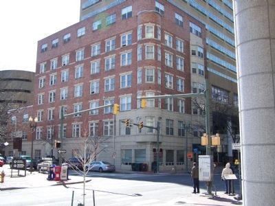
This stately Georgian Revival-styled edifice at 333. S. Thirteenth Street was completed in 1909 as the home of prominent Harrisburg attorney A. Carson Stamm (1863-1939); The building is unique both in location as a single home nestled within the . . . — — Map (db m31292) HM
The centerpiece of improvements to Harrisburg's marvelous park system, launched in 1902, was the "Crown Jewel" of Reservoir Park situated at the city's summit. Adjacent to this summit, flowing to the south, were the open fields of an old farm named . . . — — Map (db m6889) HM
Standing picturesquely upon a slope rising to the summit of Reservoir Park and at the apex of Market Street's climb from Center City is Bishop McDevitt High School, primary parochial secondary school serving the City of Harrisburg and the Harrisburg . . . — — Map (db m6888) HM
Quietly nestled at the corner of 21st Street and Bellevue Road is a true historic landmark: the home of the internationally recognized founder of the American Civic Association and modern-day American Rose Society, J. Horace McFarland (1859-1948). . . . — — Map (db m6893) HM
In the home at 329 S. Front Street between 1866 and 1880 resided Brigadier General Joseph Farmer Knipe (1823-1901), accomplished Union commander during the Civil War. It was Knipe who named Camp Curtin, the largest Civil War troop deployment camp . . . — — Map (db m121988) HM
The Broad Street Market consists of the oldest continuously operated market houses in the United States. By the advent of the Civil War, Harrisburg began to develop north of North Street onto the newly subdivided lands of William Verbeke, John . . . — — Map (db m106002) HM
Harrisburg's Civil War importance as a transportation center and state capital became strikingly clear upon the fall of Fort Sumter in Charleston Harbor, South Carolina, in April of 1861 when President Abraham Lincoln and Pennsylvania Governor . . . — — Map (db m202196) HM
The deliberations during the first decade of the 19th Century through which Harrisburg prevailed in achieving State Capital status were in part spawned by the donation by John Harris, Jr., in 1785, of four acres of the oldest portion of Capitol Park . . . — — Map (db m6696) HM
This 63-acre Susquehanna River jewel and major tourism and recreational destination has lured human occupations not just since Harrisburg was founded and throughout the ensuing centuries but also by prehistoric native Americans beginning at least . . . — — Map (db m7098) HM
As the City of Harrisburg grew northward during the latter part of the 19th Century, N. Front Street had not yet attained its distinction as a prime residential boulevard. The riverbank, which was littered with sewage and debris, and adjacent low . . . — — Map (db m137432) HM
The coming of the railroad to Harrisburg in 1836 led to the construction of the first bridges to span the Susquehanna, since the building of the Camelback Bridge in 1817, which planted the seed for what would become the city's trademark of . . . — — Map (db m44405) HM
The structure across the street is the oldest bank building in the Harrisburg Metropolitan Area and stands as an icon to the financial institution that helped to fuel the City's growth since the 1830's. Survivor of several Economic Panics, the Civil . . . — — Map (db m6632) HM
On the site directly across the street stood the Eagle Hotel, a three-story brick structure opened by George Buehler in January of 1812. It was here that Charles Dickens stayed when touring America in 1842 during which time he authored "American . . . — — Map (db m6750) HM
By the end of the 19th Century, Harrisburg's distinction as State Capital, transportation center and nucleus of industry unleashed development energy to keep pace with the pressing need for housing in the rapidly growing city. Builders emerged to . . . — — Map (db m6254) HM
Harrisburg's distinction as the Susquehanna River's trademark is garnered through both its stunning riverfront setting and its ever-growing skyline, presenting a panorama of urban vitality and economic health. Since 1822 when the Federal-styled dome . . . — — Map (db m137435) HM
One block northeast of Harrisburg's Market Square is located a place that became known by the end of the 19th century as Federal Square, the block bounded by N. Third, Locust, Court and Walnut Streets. Since 1877, this block has been the site of the . . . — — Map (db m6695) HM
The simultaneous completion of Harrisburg's two state-of-the-art high schools in September of 1926 represented a milestone in the deliverance of quality public education to a city which had grown so rapidly in the first quarter of the 20th Century . . . — — Map (db m137430) HM
In the building at the northwest corner of N. Second and Walnut Streets lived George J. Heisely (1789-1880) who was a Harrisburg mathematical instrument and clockmaker. Heisely had joined the First Regiment of the Pennsylvania Militia's First . . . — — Map (db m106004) HM
This fine collection of historic Front Street townhouses is the single most important row of homes that can be associated with the lives of early Pennsylvania Governors. The original houses on the block; Federal in style and dating to 1812 were . . . — — Map (db m6374) HM
This church, built between 1873 and 1878, can be said to have saved Harrisburg from losing its status as the Capital of Pennsylvania. Since 1809, efforts were made to return the Capital from its temporary location at Lancaster to Philadelphia . . . — — Map (db m202206) HM
On the southeast corner of N. Third and Walnut Streets stood the Grand Opera House, erected in 1873 at a cost of $160,000, by the Masonic Fraternity and designed by architect Frank E. Davis. Serving also as the Harrisburg Masonic Temple, lodge rooms . . . — — Map (db m6748) HM
By 1929, Harrisburg's growth as a freight and passenger rail hub in the eastern United States necessitated the introduction of new rail interlocking technologies to guide the convergence of high volume locomotive traffic through the city. At that . . . — — Map (db m6849) HM
Here is established Harrisburg's oldest and largest Cemetery and final resting place of many noted individuals of national, state and local importance in all walks of life. Chartered in 1845, the Cemetery was created just outside the limits of the . . . — — Map (db m6851) HM
Harrisburg Hospital, the city's first public hospital, opened in the former South Ward School building in 1873, beginning a course that today makes Harrisburg a major health and research center. The school faced Mulberry Street (now vacated) which . . . — — Map (db m6600) HM
Founded in 1889, the Harrisburg Public Library became a national model of 19th Century efforts to bring the world's information to community residents, a role that continues today. Its first home was at 125 Locust Street in a building erected by . . . — — Map (db m6346) HM
First known as the "City on the Hill,” the Harrisburg State Hospital was opened in 1851 as Pennsylvania's first institution built tor the care and treatment of the mentally ill, and one of the first such facilities in the United States. By the . . . — — Map (db m224203) HM
When it opened amidst regalia and fanfare in the fall of 1990, the Hilton Harrisburg and Towers reclaimed Harrisburg's traditional role as Central Pennsylvania's primary destination for the lodging and conference industry. Although plans for a . . . — — Map (db m6556) HM
Just prior to the Civil War, Harrisburg's northern development reached only as far as North Street, although its northern boundary extended to Herr Street under an annexation to the original Borough in 1838. In 1860, Harrisburg was incorporated as a . . . — — Map (db m6794) HM
Directly across this street stands the Hope Fire Station, oldest fire station in Harrisburg and one of the oldest in the U.S. It was originally owned by the Hope Fire Company, which was organized in 1814, and which built this building in 1871. . . . — — Map (db m6740) HM
As early as 1903, reference was made to a strip of ground at the "head of Second Street" above Division Street which would become part of the comprehensive parks improvement plan advanced by landscape architect Warren Manning of Boston at the start . . . — — Map (db m6485) HM
U.S. Senator, 1877-97. Secretary of War under Ulysses Grant, 1876-77. President, Northern Central R.R., 1863-74. Son of Simon Cameron. His mansion here, acquired 1870, had many visitors and was the scene of major political and business decisions. — — Map (db m6299) HM
During the midst of the Civil War fury in 1863 would rise this magnificent residence, situated directly across this street, which was purchased in 1870 by J. Donald Cameron (1833-1918), son of Simon Cameron. The elder Cameron had served as President . . . — — Map (db m6297) HM
This house was built in 1869 by James McCormick, Jr. (1832-1917), a noted banker, industrialist, community leader and member of one of Harrisburg's oldest families. His father, James McCormick Sr., was one of the early Presidents of Dauphin Deposit . . . — — Map (db m6344) HM
Here is situated the stone residence of John Harris, Jr. (1727-1791), the founder of Harrisburg, which he erected at the end of the French and Indian War in 1766. In 1785, the Borough of Harrisburg was laid out in the house's front parlor by Harris . . . — — Map (db m6594) HM
Here lies John Harris, Sr., father of the founder of the City of Harrisburg, who emigrated from Yorkshire England in the early 18th Century to share in the opportunities of William Penn's new world. First locating in Philadelphia, Harris made his . . . — — Map (db m6596) HM
Although Harrisburg was designated State Capital in 1810 and has had a State Capitol Building since 1822, it was not until just prior to the Civil War in 1858 that an official Governor's residence was procured. Prior to that time, Pennsylvania . . . — — Map (db m6289) HM
This building was erected in 1914 as the home of the Mechanics Trust Company, a Harrisburg bank that later went "bust" during the Depression. the Bank was one of many of the era that made Harrisburg the region's financial center, a role the city has . . . — — Map (db m6657) HM
This building was erected in 1835 in the Greek Revival architectural style and was originally known as the Wilson Hotel. Such notables as Daniel Webster and singer Jenny Lind stayed here. It was a nationally known favorite of 19th Century political . . . — — Map (db m6656) HM
Perched prominently on Reservoir Park's western slope is the picturesque Mansion at Reservoir Park, a fitting completion to the natural and cultivated beauty of this stunning hilltop retreat and vantage point for views and vistas of the Harrisburg . . . — — Map (db m137420) HM
Here is situated the nationally renowned historic and contemporary urban hub of the City of Harrisburg and the Greater Harrisburg Metropolitan Area. Laid out as the center focus of John Harris, Jr.'s plan in 1785 when Harrisburg was a launching . . . — — Map (db m6592) HM
With its roots dating to 1794 and having evolved from the earlier Paxton Presbyterian Church east of the city in what would become Paxtang, the Presbyterian Church of Harrisburg originally met in rooms of the old jail, on Walnut Street, and in the . . . — — Map (db m6576) HM
Perhaps the single-most important event that would trigger the public's embrace of Harrisburg's City Beautiful movement was the speech given on the evening of December 20, 1900, to the Harrisburg Board of Trade by social reformer and . . . — — Map (db m6257) HM
Located in this building at Mulberry and Crescent Streets was what became known as the "Switchboard of America," the printing business and national clearinghouse operation of J. Horace McFarland (1859-1948), one of Harrisburg's most famous national . . . — — Map (db m6850) HM
The linkage of downtown Harrisburg with the emerging Allsion Hill at this location was established in 1891 with the opening of the original Mulberry Street Bridge. Hailed at that time by Harrisburg civic leader J. Horace McFarland as "the day . . . — — Map (db m6659) HM
Two Dauphin County Courthouses occupied this site at the intersection of Market St. and what was originally known as Raspberry Street, later appropriately renamed Court Street. John Harris, Jr.'s original plan for Harrisburg set aside this land for . . . — — Map (db m6652) HM
The second Dauphin County Prison stood on the southeast corner of Walnut and Court Streets. Completed in 1841, it replaced a log structure erected circa 1792 at the time that the first Dauphin County Courthouse was built directly behind this . . . — — Map (db m6749) HM
Founded in 1784 by John Harris Jr., through profits generated by his Ferry across the Susquehanna, the Harrisburg Academy erected this riverside campus in 1908. The school was officially incorporated through an Act of the State Legislature in 1809 . . . — — Map (db m6479) HM
Harrisburg grew from its earliest days due to its strategic location as a gateway to western expansion, becoming one of the most important inland centers of U.S. transportation and trade. The development of rail lines along the same routes as the . . . — — Map (db m6687) HM
On the site of the present Market Street Post Office Building stood until the early 1960’s the old Philadelphia & Reading Railroad Station, Harrisburg’s second passenger terminal that exemplified the City’s prominence and traditional role as . . . — — Map (db m102271) HM
The church which stands at S. Third and Chestnut Streets is the oldest standing church building in Harrisburg, erected in 1822. It however represents the second building on this lot granted by John Harris, Jr. for religious purposed when the Borough . . . — — Map (db m102334) HM
This marvelous Tudor Revival-styled facility is one of the oldest buildings in Harrisburg still standing that was originally erected for use as a school and is the oldest schoolhouse on Allsion Hill. Prior to the industrialization of eastern . . . — — Map (db m31293) HM
The prominence of Harrisburg's State Street, between the Capitol and the Susquehanna River, is enhanced by the presence of two Roman Catholic edifices. While the Cathedral of St. Patrick, closer to the Capitol, helps to capture the grandeur of the . . . — — Map (db m6731) HM
Although the original Borough of Harrisburg and its oldest neighborhoods comprise the area now occupied by the Central Business District, the city's oldest structure is ironically located at its eastern end amidst 20th Century development. This . . . — — Map (db m6887) HM
The rise of Harrisburg's importance and distinction as one of the major transportation centers in the eastern United States was launched on March 14, 1827, by the laying of the cornerstone at the eastern end of Walnut Street downtown for the . . . — — Map (db m6831) HM
The Pennsylvania Governor's Residence is located at a spot so stunning that it captures the essence of the Commonwealth's beauty through sweeping vistas of the Susquehanna at a point where the state's piedmont greets the blue mountains of the great . . . — — Map (db m6249) HM
Established in 1903, the Pennsylvania State Archives was originally a division of the Pennsylvania State Library which was housed in the Old Executive Office Building (now the Matthew J. Ryan Legislative Office Building) located just south of the . . . — — Map (db m102274) HM
With 24 acres under one roof, this sprawling complex of buildings was erected for what has become the largest indoor agricultural event in North America, the Pennsylvania State Farm Show. In 1851, the first statewide agricultural exhibition was held . . . — — Map (db m137386) HM
Upon the destruction of the Old Capitol Building in 1897, the sense of loss was quickly replaced by a new spirit of community advancement for which the construction of a new Capitol Building would act as catalyst. In order to continue the operations . . . — — Map (db m154747) HM
The explosion in the growth of Uptown Harrisburg in the last two decades of the 19th Century required the construction of a new fire station, the first to be located north of Reily Street. On July 11, 1885, the Reily Hose Company was organized and . . . — — Map (db m6797) HM
This land, the largest park in south-central Pennsylvania, and which crowns the city's summit, contrastingly complements Harrisburg's magnificent riverfront. Originally known as Prospect Hill because of its lofty vantage points, the name was changed . . . — — Map (db m6853) HM
This building, the only municipal headquarters building in the world to be named after the civil rights leader, was built for and has served as Harrisburg's City Hall since June, 1982. As part of its efforts to revitalize Center City Harrisburg, . . . — — Map (db m6605) HM
Harrisburg's distinction of having one of the most beautiful inland waterfronts in America is attributed to the growth and conservation of Riverfront Park. Through the foresight of John Harris, Jr., the founder of Harrisburg, 6.2 linear acres along . . . — — Map (db m6401) HM
The magnificent Renaissance Revival-styled Seat of the Roman Catholic Diocese of Harrisburg is the second to rise from this prominent State Street property. Completed in 1907, Saint Patrick's Cathedral replaced its more modest predecessor, which was . . . — — Map (db m245591) HM
Although Harrisburg's northern boundary when incorporated as a city in 1860 reached as far as Maclay Street, it would not be until the early 1890's that development widely occurred above Reily Street. Local homebuilder Benjamin Engle launched the . . . — — Map (db m6796) HM
The master plan for the development of the Pennsylvania Capitol Complex was expanded at the close of World War I to include the erection of a colossal bridge which would memorialize those who fought in that War. Such a bridge would punctuate the . . . — — Map (db m6829) HM
The evolution of the English and German-speaking Lutheran congregations in Harrisburg resulted in the establishment of a number of churches that has helped to enhance the city's fabric of sacred architecture and history. From the oldest site at . . . — — Map (db m6730) HM
As early as the days of John Harris in the mid-18th Century, Harrisburg has well provided for the storage and distribution of military munitions and supplies. Even prior to the completion of the first state capitol building in 1822, an arsenal was . . . — — Map (db m6852) HM
Phase I of Strawberry Square represents the birth of downtown Harrisburg's revitalization and renewal activity that commenced in the mid 1970's and was pursued with fervor in the 1980's and since. The demolition of the renowned Penn-Harris Hotel at . . . — — Map (db m6747) HM
This block of historic buildings traces a glimpse of Harrisburg's 19th and 20th Century retail development. Restored as Phase II of the Strawberry Square shopping complex in the late 1980's and part of the Old Downtown Harrisburg Commercial Historic . . . — — Map (db m6655) HM
Throughout the 19th Century, lumbering on the Susquehanna River was a major industry. Logs were cut from the forests in the northern part of the state and floated down river to sawmills at Harrisburg and points further south. A popular place where . . . — — Map (db m159640) HM
"The Acropolis of Harrisburg" is a way in which to describe this Greek Revival, temple-like edifice that rests on a mound of retaining walls jutting from Allison Hill. Although these walls are relatively recent, built when the structure was . . . — — Map (db m6830) HM
Erected in 1910 and designed by noted Harrisburg architect Charles Howard Lloyd, this building served as the main boy's high school of the City of Harrisburg. Known as the Technical High School, the building replaced, on the same site, the . . . — — Map (db m6691) HM
The origins of the mansion at 105 N. Front Street can be attributed to William Calder, Jr. (1821-1880), Simon Cameron's business partner, banker and manufacturer. Calder's father had been a preeminent Harrisburg stage coach operator and helped to . . . — — Map (db m6341) HM
This building, one of only two to survive on the west side of Front Street and ensconced within the idyllic setting of Riverfront Park, was erected between 1901 and 1903 by William Reynolds Fleming as a single family home which he named "Overlook." . . . — — Map (db m6329) HM
This building was erected in 1920 for the offices of the Pennsylvania Public Services Commission and was one of the first buildings in downtown Harrisburg intended to be leased for state offices. Originally known as the Claster Building, having been . . . — — Map (db m6604) HM
The current era of hostelries in Harrisburg can be defined as having begun in 1965 with the construction of the Holiday Inn Town, now The Crowne Plaza. Prior to that time, the Harrisburger and Penn-Harris Hotels, at Third and Locust and Third and . . . — — Map (db m6561) HM
Although the Founder of Harrisburg, John Harris, Jr., was a member of the Church of England, it was not until 1826 that a permanent Episcopal church building was erected here. Consecrated on St. John's Day, 1827, by Bishop William White, who was . . . — — Map (db m6333) HM
Founded in 1844 in London, England, by George Williams, the Young Men's Christian Association quickly grew in the United States with Harrisburg, in 1854, being one of the first eight cities in the nation to establish a chapter. Located at various . . . — — Map (db m6732) HM
1906 was a banner year in Harrisburg for the construction of major buildings. The new State Capitol Building was completed that year and two "book-end" office structures were developed on Market Square. One was the eight-story Union Trust Building . . . — — Map (db m6560) HM
On this site, the southeast corner of Second and Market Streets on Market Square, stood the Jones House, a mid-Nineteenth Century Hotel, which later evolved into the larger Commonwealth Hotel and later, the Dauphin Building. It was here that Abraham . . . — — Map (db m6550) HM
In the house at 223 N. Front Street lived two 19th Century Pennsylvania Governors, William Bigler (1852-1855) and James Pollock (1855-1858). Also here resided U.S. Army Major Marcus Reno, the controversial survivor of the Battle of Little Big Horn, . . . — — Map (db m6330) HM
The soldiers and sailors of Harrisburg and Dauphin County who gave their lives during the Civil War were commemorated with the 1866 start-up of construction of the Obelisk in the center of the downtown intersection of N. Second and State Streets. . . . — — Map (db m6729) HM
By the late 1880's, the Old Capitol Building erected in 1822 was becoming limited in space due to the inevitable expansion of state government. A public debate ensued as to whether a new Capitol should be erected, although many had a sentimental . . . — — Map (db m6746) HM
The development and evolution of Harrisburg's early public works infrastructure is captured through the unique Riverfront Park setting of the Old Waterworks, the original stone portion of which was constructed in 1841. At that time water was pumped . . . — — Map (db m6736) HM
On this site for nearly 180 years stood a two and a-half story brick building with ties to local, state and national history. Initially the home of early settler John Frey, the house was sold in 1817 to a noted clockmaker, Frederick Heisley, whose . . . — — Map (db m6574) HM
The notable Tudor Revival-styled edifice situated at the southeast corner of N. Front and Muench Streets well exemplifies the grand Front Street mansions of the early 20th Century that would rise north of Forster Street. The house was built in 1917 . . . — — Map (db m6250) HM
Harrisburg's prominent role in the advance of the Union cause leading to the Civil War was particularly evident by its sympathy in harboring former slaves who had escaped servitude from the South. As early as 1836, the Harrisburg Anti-Slavery . . . — — Map (db m168922) HM
Touted as "Harrisburg's First Skyscraper," the Union Trust Building was completed in 1906 and exemplified the beginning of Center City's 20th Century upward growth, particularly as spawned by the completion of the new State Capitol Building that . . . — — Map (db m6607) HM
Located just across N. Fourth Street from Strawberry Square is Walnut Place, a slice of old downtown Harrisburg comprised of a series of late 19th and early 20th Century restored buildings and storefronts. Pictured here is the Rodearmel/German . . . — — Map (db m6694) HM
This bridge, completed in 1890, is the oldest surviving structure to have spanned the Susquehanna River and is one of the largest multi-span, truss bridges ever fabricated by the nationally significant Phoenix Bridge Company. It is also the oldest . . . — — Map (db m6372) HM
Whitaker Center for Science and the Arts, which opened September 9, 1999, is the successful culmination of decades worth of community effort to develop a major performing arts and science center in downtown Harrisburg. The resources which were . . . — — Map (db m6654) HM
Here at the base of Blue Mountain and within the City of Harrisburg's northern tier lies the 212-acre Wildwood Lake Sanctuary, the last vestige and magnificent preserve of the Susquehanna flood-plain wetlands which at one time were common prior to . . . — — Map (db m7101) HM
Situated across this street is the home of William Maclay (1737-1804); statesman, surveyor, lawyer, the Country's first U.S. Senator and son-in-law of John Harris Jr., the founder of Harrisburg. It was Maclay and Harris who laid out the plan of . . . — — Map (db m6291) HM
The growth in the activities and membership of the Harrisburg Masonic Shriners had by the end of the 1920's, resulted in the demand for a grand new facility. The emergence of Italian Lake Park, William Penn High School and the establishment of . . . — — Map (db m6482) HM
"Tippecanoe and Tyler Too" was the familiar political slogan of the 1839 Presidential Campaign. The Campaign began when William Henry Harrison and John Tyler were nominated as the Whig candidates for U.S. President and Vice President in this church, . . . — — Map (db m6662) HM