138 entries match your criteria. The first 100 are listed. ⊳
Former U.S. Presidents: #17 Andrew Johnson Historical Markers
By Sandra Hughes
Mooresville Marker
| 1 ► Alabama, Limestone County, Mooresville — Cottonport / Mooresville — |
| On Old Highway 20 at Mooresville Road on Old Highway 20. | |||
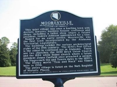
| 2 ► Alabama, Limestone County, Mooresville — Mooresville — Incorporated in 1818 — |
| On Old Highway 20 at Mooresville Road on Old Highway 20. | |||
| 3 ► Arkansas, Benton County, Bella Vista — United States Commanders in Chief — |
| 4 ► Arkansas, Sebastian County, Fort Smith — Meeting of Nations — Fort Smith National Historic Site — National Park Service, U.S. Department of the Interior — |
| On Park Avenue, on the left when traveling north. | |||
| 5 ► California, Monterey County, Big Sur — 951 — Point Sur Light Station — |
| Near Cabrillo Highway (California Route 1), on the right when traveling south. | |||
| 6 ► California, Napa County, Yountville — Flags over California in 1870 — |
| Near Washington Street near Yount Street, on the left when traveling north. | |||
| 7 ► California, Santa Cruz County, Davenport — Swanton Pacific Ranch — The History of Swanton — As told by Al Smith, July, 1990 — |
| Near Stanton Road near Big Creek Road, on the left when traveling north. | |||
| 8 ► California, Solano County, Vallejo — 16 — D.C. Madam's House — |
| On Capitol Street near Napa Street, on the right when traveling east. | |||
| 9 ► District of Columbia, Washington, Northwest Washington, Capitol Hill — Acacia Life Insurance Building – 1936 — |
| On Louisiana Avenue Northwest west of North Capitol Street Northwest, on the right when traveling west. | |||
| 10 ► District of Columbia, Washington, Northwest Washington, Chinatown — e.5 — Mary Surratt's Boarding House — Civil War to Civil Rights — Downtown Heritage Trail |
| On H Street Northwest just west of 6th Street Northwest (U.S. 1/50), on the right when traveling east. Reported permanently removed. | |||
| 11 ► District of Columbia, Washington, Northwest Washington, Downtown — A Fortress of Finance: The US Treasury Building — The White House — National Park Service, U.S. Department of the Interior — |
| Near Pennsylvania Avenue Northwest west of 15th Street Northwest, on the left when traveling west. | |||
| 12 ► District of Columbia, Washington, Northwest Washington, Dupont Circle — After the Civil War — Dupont Circle — Diverse Visions | One Neighborhood |
| On P Street Northwest at 17th Street Northwest, on the left when traveling west on P Street Northwest. Reported unreadable. | |||
| 13 ► District of Columbia, Washington, Northwest Washington, Georgetown — The Colonial — Erected 1820 · Restored 1953 — |
| On 30th Street Northwest north of N Street Northwest, on the right when traveling north. | |||
| 14 ► District of Columbia, Washington, Northwest Washington, Penn Quarter — .2 — Ceremony at the Crossroads — Civil War to Civil Rights — Downtown Heritage Trail |
| On 7th Street Northwest at Indiana Avenue Northwest, on the right when traveling north on 7th Street Northwest. Reported permanently removed. | |||
| 15 ► District of Columbia, Washington, Northwest Washington, Penn Quarter — .2 — Ceremony at the Crossroads — Civil War to Civil Rights — Downtown Heritage Trail — |
| On 7th Street Northwest at Indiana Avenue Northwest, on the right when traveling north on 7th Street Northwest. | |||
| 16 ► District of Columbia, Washington, Northwest Washington, Penn Quarter — .6 — John Wilkes Booth’s Escape — Civil War to Civil Rights — Downtown Heritage Trail |
| On F Street Northwest west of 9th Street Northwest, on the right when traveling east. Reported permanently removed. | |||
| 17 ► Florida, Monroe County, Key West — In Memory of Dr. Samuel A. Mudd — 1833 - 1883 — Imprisoned Fort Jefferson, Florida (July 24, 1865) — |
| 18 ► Florida, Nassau County, Fernandina Beach — F-376 — The Lesesne House — |
| On Centre Street near N 5th Street, on the right when traveling west. | |||
| 19 ► Georgia, Baldwin County, Milledgeville — L14 — The Old Governor's Mansion — "Utmost Disorder and Confusion" — March to the Sea Heritage Trail — |
| On South Clarke Street (Business U.S. 441) south of East Hancock Street, on the left when traveling south. | |||
| 20 ► Georgia, Chatham County, Savannah, Historic District - North — 25-37 — History Of Emancipation: Special Field Orders No. 15 — |
| On Bull Street at Harris Street, on the left when traveling south on Bull Street. | |||
| 21 ► Illinois, Adams County, Quincy — The Browning House — |
| On Hampshire Street at 7th Street, on the right when traveling east on Hampshire Street. | |||
| 22 ► Kansas, Leavenworth County, Leavenworth — Law Offices of Sherman, Ewing, and McCook — 60 Main Street — 1858 - 1859 — |
| On Esplanade Street at Delaware Street, on the right when traveling south on Esplanade Street. | |||
| 23 ► Kentucky, Campbell County, Fort Thomas — 1059 — Hon. Henry Stanbery |
| On North Fort Thomas Avenue, 0.1 miles south of Stanbery Ridge, on the left when traveling south. Reported unreadable. | |||
| 24 ► Kentucky, Knox County, Barbourville — The Battle of Barbourville — September 19, 1861 — First Kiosk — |
| On Daniel Boone Drive (State Highway 11) at Cumberland Avenue (State Highway 2421), on the right when traveling west on Daniel Boone Drive. | |||
| 25 ► Maine, Kennebec County, Augusta — 12 — Maine's Voice Against Slavery / Le Maine Proteste Contre l'Esclavage — |
| On Winthrop Street at Wyman Street, on the right on Winthrop Street. | |||
| 26 ► Maine, York County, Kennebunk — 21 — Hugh McCulloch Home / La demeure Hugh McCulloch — Kennebunk, Maine — The Museum in the Streets® — |
| On Summer Street (Maine Route 9A/35) just west of Durrell's Bridge Road, on the left when traveling west. | |||
| 27 ► Maine, York County, Kennebunk — The McCulloch House — Built in 1782 Birthplace of Hugh McCulloch — 1808 - 1895 — |
| On Summer Street (Maine Route 9A/35) at Durrell's Bridge Road, on the right when traveling west on Summer Street. | |||
| 28 ► Maryland, Charles County, Port Tobacco — Port Tobacco: Conspiracy & the Plot to Assassinate President Lincoln — |
| Near Commerce Street west of Chapel Point Road when traveling west. | |||
| 29 ► Maryland, Charles County, St. Charles — Dr. Samuel A. Mudd — Treating an Assassin — John Wilkes Booth – Escape of An Assassin — |
| On Dr. Samuel Mudd Road (Maryland Route 232) near Poplar Hill Road (Maryland Route 382). | |||
| 30 ► Maryland, Kent County, Chestertown — Senator George Vickers — Helped Acquit President Andrew Johnson — |
| Near High Street (Maryland Route 20) 0.2 miles west of Flatland Road (Maryland Route 514). | |||
| 31 ► Maryland, St. Mary's County, Leonardtown — The Mural Story — |
| On Washington Street (Business Maryland Route 5) near Leonardtown Road (Business Maryland Route 5), on the right when traveling north. | |||
| 32 ► Maryland, Washington County, Sharpsburg — Not For Themselves, But For Their Country — Inscription from the Private Soldier Monument in the center of the Cemetery — Antietam National Battlefield, National Park Service, U.S. Department of the Interior — |
| On East Main Street (Maryland Route 34) 0.1 miles east of Truman Lane, on the right when traveling east. | |||
| 33 ► Missouri, Pike County, Louisiana — John Brooks Henderson — Nov. 16, 1826 - April 12, 1913 — |
| On North Main Street at Jackson Street, on the right when traveling north on North Main Street. | |||
| 34 ► Montana, Gallatin County, Bozeman — Fort Ellis — |
| On Old Route 191 at Fort Ellis Road when traveling east on Old Route 191. | |||
| 35 ► New York, Cayuga County, Auburn — William H. Seward — Born 1801 — Died 1872 — Resided in This House 1824-1872 — |
| On South Street (New York State Route 34) at Grover Street, on the right when traveling south on South Street. | |||
| 36 ► New York, Erie County, Buffalo, Black Rock — The Fenian Invasion of 1866 — |
| On Hertel Avenue, 0.3 miles west of Niagara Street (New York State Route 266), on the right when traveling west. | |||
| 37 ► New York, Monroe County, Rochester, Highland — Frederick Douglass Home Site — |
| On South Avenue, 0.2 miles north of Rockingham Street, on the left when traveling north. | |||
| 38 ► New York, New York County, Manhattan, Morningside Heights — Carl Schurz Monument — Morningside Park — |
| On Morningside Drive at West 116th Street, on the left when traveling south on Morningside Drive. | |||
| 39 ► North Carolina, Durham County, Durham, Bennett Place — Unity — |
| On Bennett Memorial Road, on the right when traveling east. | |||
| 40 ► North Carolina, Macon County, Franklin — Thomas's Legion — A Unique Command — |
| On West Main Street (Business U.S. 441) east of Macon Avenue. | |||
| 41 ► North Carolina, Wake County, Raleigh, Downtown — H-6 — Andrew Johnson — 1808 - 1875 — |
| On East Morgan Street at S Wilmington Street, on the right when traveling east on East Morgan Street. | |||
| 42 ► North Carolina, Wake County, Raleigh, Downtown — Andrew Johnson Birth Site — |
| On Fayetteville Street north of W Hargett Street, on the right when traveling north. | |||
| 43 ► North Carolina, Wake County, Raleigh, Downtown — Presidents North Carolina Gave The Nation — |
| Near North Wilmington Street near New Bern Avenue. | |||
| 44 ► North Carolina, Wake County, Raleigh, Mordecai — H-11 — Andrew Johnson — 1808 - 1875 — |
| On Wake Forrest Road at Cedar Street, on the right when traveling south on Wake Forrest Road. | |||
| 45 ► North Carolina, Wake County, Raleigh, Mordecai — Birthplace of Andrew Johnson — |
| On Cedar Street at Wake Forrest Road, on the left when traveling west on Cedar Street. | |||
| 46 ► Ohio, Columbiana County, Wellsville — The Whitacre House Site — |
| On Main Street at 4th Street, on the right when traveling north on Main Street. | |||
| 47 ► Ohio, Franklin County, Columbus, Hilltop — Camp Chase — The Historic National Road in Ohio — |
| On West Broad Street (Old National Road) (U.S. 40) west of South Roys Avenue, on the left when traveling west. | |||
| 48 ► Ohio, Hamilton County, Cincinnati, Central Business District — 61-31 — Salmon Portland Chase — |
| On East 3rd Street at Main Street, on the left when traveling west on East 3rd Street. | |||
| 49 ► Ohio, Jefferson County, Steubenville — 7-41 — Secretary of War Edwin M. Stanton — |
| On Market Street at North 3rd Street, on the left when traveling east on Market Street. | |||
| 50 ► Ohio, Warren County, Franklin — 11-83 — Lewis Davis Campbell / Robert Cumming Schenck — |
| On 254 South River Street. | |||
| 51 ► Pennsylvania, Dauphin County, Harrisburg — Harrisburg's Grand Review of Black Troops |
| On South Front Street at Mary Street, on the left when traveling south on South Front Street. Reported damaged. | |||
| 52 ► Pennsylvania, Dauphin County, Harrisburg — Market Square During The Civil War — |
| On North 2nd Street at Market Street, on the left when traveling west on North 2nd Street. | |||
| 53 ► Pennsylvania, Lancaster County, Lancaster — Stevens Grave & Memorial — Shreiner-Concord Cemetery — |
| On West Chestnut Street east of North Mulberry Street, on the right when traveling east. | |||
| 54 ► Pennsylvania, Lancaster County, Lancaster — Thaddeus Stevens — |
| On Stevens Drive south of East King Street (Pennsylvania Route 462), on the left when traveling south. | |||
| 55 ► South Carolina, Greenville County, Greenville — 23-37 — Sans Souci — |
| On West Blue Ridge Drive (State Highway 253) at North Franklin Road, on the right when traveling east on West Blue Ridge Drive. | |||
| 56 ► South Carolina, Laurens County, Laurens — 30-6 — Laurens County / Laurens Historic District — |
| On West Laurens Street near Laurel Street. | |||
| 57 ► South Dakota, Custer County, Custer — An Agreement Between Cultures — The Fort Laramie Treaty Created the Great Sioux Reservation — |
| Near U.S. 16A east of Lower French Creek Road, on the right when traveling east. | |||
| 58 ► Tennessee, Benton County, Eva — Battle of Johnsonville — |
| Near Pilot Knob Road (Tennessee Route 191) 0.2 miles east of Cherry Ridge Road. | |||
| 59 ► Tennessee, Benton County, Holladay — Fort Johnson — Controlling the Tennessee River — |
| Near Interstate 40 at milepost 130, on the right when traveling east. | |||
| 60 ► Tennessee, Carter County, Elizabethton — 1A 20 — Andrew Johnson — |
| On State Highway 91 at Broad Street, on the right when traveling east on State Highway 91. | |||
| 61 ► Tennessee, Carter County, Elizabethton — Samuel P. Carter — Admiral and General — |
| On North Main Street at East Elk Avenue, on the right when traveling north on North Main Street. | |||
| 62 ► Tennessee, Cocke County, Parrottsville — Johnson's Parrottsville Slaves — Origin of Tennessee Emancipation Day — |
| On Tennessee Route 340 at Old Hwy 321, on the right when traveling north on State Route 340. | |||
| 63 ► Tennessee, Coffee County, Tullahoma — Tullahoma Campaign — June 24-July 4, 1863 — From Contraband to United States Colored Troops — |
| On South Jackson Street (U.S. 41A) at West Volney Street, on the right when traveling south on South Jackson Street. | |||
| 64 ► Tennessee, Davidson County, Nashville — War on the Home Front — Belle Meade and Union Occupation — |
| Near Harding Pike (U.S. 70S) 0.2 miles north of Leake Avenue, on the right when traveling north. | |||
| 65 ► Tennessee, Davidson County, Nashville, Downtown — 3A 77 — Maxwell House Hotel — |
| On Church Street, 0.1 miles west of 4th Avenue North, on the left when traveling east. | |||
| 66 ► Tennessee, Davidson County, Nashville, North Capitol — Andrew Johnson — 1808-1875 — |
| On Charlotte Avenue. | |||
| 67 ► Tennessee, Davidson County, Nashville, North Capitol — First General Assembly to meet in new Capitol — |
| On 7th Avenue North, on the left when traveling south. | |||
| 68 ► Tennessee, Davidson County, Nashville, North Capitol — Lincoln Assassinated — |
| On 7th Avenue North, on the left when traveling south. | |||
| 69 ► Tennessee, Davidson County, Nashville, North Capitol — 3A 38 — Nashville Inn — |
| On James Robertson Parkway (U.S. 431) just east of 2nd Avenue North, on the right when traveling west. | |||
| 70 ► Tennessee, Davidson County, Nashville, North Capitol — President Lincoln and Vice President Andrew Johnson — |
| On 7th Avenue North, on the left when traveling south. | |||
| 71 ► Tennessee, Davidson County, Nashville, North Capitol — Two Governors, Two Governments — The Capitol in the Civil War — |
| On 6th Avenue North, on the left when traveling east. | |||
| 72 ► Tennessee, Davidson County, Nashville, South Nashville — Fort Negley — Defending the Capital — Hood's Campaign — |
| On Fort Negley Boulevard north of Chestnut Street, on the right when traveling north. | |||
| 73 ► Tennessee, Davidson County, Nashville, Whites Creek — White’s Creek and the War — Fighting for Tennessee — |
| Near 4125 Whites Creek Pike. | |||
| 74 ► Tennessee, Dickson County, Charlotte — Civil War In Charlotte — "Marauding gangs of Freebooters" — |
| On Court Square east of Clark Street, on the left when traveling east. | |||
| 75 ► Tennessee, Gibson County, Trenton — 4B 35 — Gibson County Courthouse — |
| On Eaton Street (Tennessee Route 104, 77) at South College Street (Tennessee Route 367), on the left when traveling east on Eaton Street. | |||
| 76 ► Tennessee, Giles County, Pulaski — Thomas McKissack Jones — (1816-1892) — Mayor-Judge Representative to Confederate Congress — |
| Near South Rhodes Street north of East Cemetery Street, on the right when traveling north. | |||
| 77 ► Tennessee, Grainger County, Bean Station — Bean Station — |
| On Bean Station Cemetery Road south of Old Lee Hwy (US 11W), on the left when traveling south. | |||
| 78 ► Tennessee, Grainger County, Bean Station — Bean Station — |
| Near U.S. 25E, on the right when traveling south. | |||
| 79 ► Tennessee, Greene County, Greeneville — "I Have Wrestled With Poverty" — |
| On E. Depot Street. | |||
| 80 ► Tennessee, Greene County, Greeneville — An Early Home — Andrew Johnson National Historic Park — |
| On E Depot Street at N College Street, on the left when traveling east on E Depot Street. | |||
| 81 ► Tennessee, Greene County, Greeneville — Andrew Johnson — National Historic Site — Andrew Johnson National Cemetery — |
| On Monument Avenue. | |||
| 82 ► Tennessee, Greene County, Greeneville — Andrew Johnson — 1808 - 1875 — |
| On E Depot Street at S College Street, on the right when traveling east on E Depot Street. | |||
| 83 ► Tennessee, Greene County, Greeneville — Andrew Johnson — |
| On West Summer Street at South Main Street, on the right when traveling west on West Summer Street. | |||
| 84 ► Tennessee, Greene County, Greeneville — 1C 91 — Andrew Johnson — |
| On E Church Street at N College Street, on the left when traveling east on E Church Street. | |||
| 85 ► Tennessee, Greene County, Greeneville — Andrew Johnson and Eliza Johnson Grave Marker — Andrew Johnson National Cemetery — |
| On Monument Avenue. | |||
| 86 ► Tennessee, Greene County, Greeneville — Andrew Johnson and Family — |
| On West Summer Street, on the right when traveling west. | |||
| 87 ► Tennessee, Greene County, Greeneville — Andrew Johnson Homestead — |
| On South Main Street. | |||
| 88 ► Tennessee, Greene County, Greeneville — Andrew Johnson National Cemetery — Andrew Johnson National Historic Site — National Park Service, U.S. Department of the Interior — |
| On Monument Avenue, on the left when traveling south. | |||
| 89 ► Tennessee, Greene County, Greeneville — Andrew Johnson National Historic Site — |
| On South Main Street. | |||
| 90 ► Tennessee, Greene County, Greeneville — 1C 50 — Andrew Johnson National Historic Site — |
| On Andrew Johnson Highway (U.S. 321), on the right when traveling east. | |||
| 91 ► Tennessee, Greene County, Greeneville — Bridge Burners — Hangings at the Depot — |
| On W Depot Street at Loretta Street, on the left when traveling west on W Depot Street. | |||
| 92 ► Tennessee, Greene County, Greeneville — 1C 93 — Ellen “Nelly” VanVactor — Free Black Female Landowner — |
| On N. Main Street (U.S. 321), on the left when traveling south. | |||
| 93 ► Tennessee, Greene County, Greeneville — 1C 54 — Greeneville Union Convention — |
| On South Main Street (U.S. 11/321) at Depot Street, on the right when traveling south on South Main Street. | |||
| 94 ► Tennessee, Greene County, Greeneville — Greeneville, Tennessee — |
| On South Main Street (U.S. 321) at E Depot Street, on the right when traveling north on South Main Street. | |||
| 95 ► Tennessee, Greene County, Greeneville — Greeneville, Tennessee — |
| On N College Street at E Church Street, on the right when traveling north on N College Street. | |||
| 96 ► Tennessee, Greene County, Greeneville — Greenville Cumberland Presbyterian Church — Founded 1841 — |
| On North Main Street (U.S. 321) at W Church Street on North Main Street. | |||
| 97 ► Tennessee, Greene County, Greeneville — Home of Andrew Johnson — |
| On S Main Street (U.S. 321), on the left when traveling south. | |||
| 98 ► Tennessee, Greene County, Greeneville — Margaret Johnson Patterson Bartlett / Andrew Johnson — |
| On E Depot Street at S College Street, on the right when traveling east on E Depot Street. | |||
| 99 ► Tennessee, Greene County, Greeneville — Preserving the President’s Legacy — Andrew Johnson National Historic Site — |
| On S Main Street (U.S. 321), on the left when traveling south. | |||
| 100 ► Tennessee, Greene County, Greeneville — The Dickson - Williams Mansion — A House Divided — |
| On West Church Street. | |||
138 entries matched your criteria. The first 100 are listed above. The final 38 ⊳